Page 1 of 3
[Abandoned] - Denmark

Posted:
Tue Mar 06, 2007 7:19 pmby Mr Tumbler
Mod Note: Similar Map developed --> viewtopic.php?f=64&t=151728Request for anyone to take over 2008-03-12Stopped playing for good now (at least I think so

). So if anyone likes this idea just take it over and continue.
If you need the maps already produced, email me at: mrtumbler at gmail dot com
New map 2007-03-19I will address the issues in this thread later. Just want to post the new map right away. The most interesting aspects are:
- The change that Hovedstaden was removed, and Storstrom was introduced
- The connection from Sjaelland to Norhtern Jutland
- The removal of a small map outside Middle Jutland.
- The new graphic design.

Posted:
Tue Mar 06, 2007 7:22 pmby Guiscard
Could work.

Posted:
Tue Mar 06, 2007 7:33 pmby Ruben Cassar
I think it would be nice to have a Denmark map.
Posted:
Tue Mar 06, 2007 8:44 pmby Loki557
I like the idea.
Posted:
Tue Mar 06, 2007 9:05 pmby Danbemp
whats denmark?
kidding.
yeah man, that is a good idea, definitely go for it.
Posted:
Tue Mar 06, 2007 9:14 pmby Samus
Well, here's my initial reactions.
I noticed your image is 700px wide. Since the small map needs to be 600px wide (the large one 800px wide), I would suggest slightly moving the outlying island to the left so that you can crop off 100px and make this your small map.
I'm not quite certain what are territories and what are not. I count around 28, and in my opinion (other disagree) no map should be fewer than 32 territories. Try to add some more territories and label them so we can give you more specific advice on that.
Posted:
Tue Mar 06, 2007 10:13 pmby Bad Speler
Denmark is a great idea.
Here is a map to help you out:
http://en.wikipedia.org/wiki/Image:Dk_adm_regions_2007.png
Couldnt find the territory names though

Posted:
Wed Mar 07, 2007 4:48 pmby Mr Tumbler
Ok, will increase the number of territories and give them names etc. Will take a few days though. Will be back.
Posted:
Wed Mar 07, 2007 5:05 pmby Nukora
I agree, Denmark has a very interesting geography for a small map. I say go for it. Twenty-seven countries however, is a small number. If you can, I suggest splitting some of them up and shoot for 36+
Six continents seems like a very reasonable number. The original Risk map has six continents. However, you have 3-5 countries in each continent. That is an okay number for one of them, but for all six to have that many is a little too few.
I'd suggest making a ferry line from that orange island (on the east side of the mainland) to the nearest blue country.
My suggestion for cotinent worth (on the current map. On a different map, the number may vary):
Yellow - 2
Purple - 3
Brown - 2
Green - 3
Blue - 4
Orange - 3
Posted:
Wed Mar 07, 2007 5:11 pmby Wisse
found this:

also this:
http://www.maps.com/map.aspx?pid=8936
You can zoom in to it

this is a perfect map (made my china map the same way:
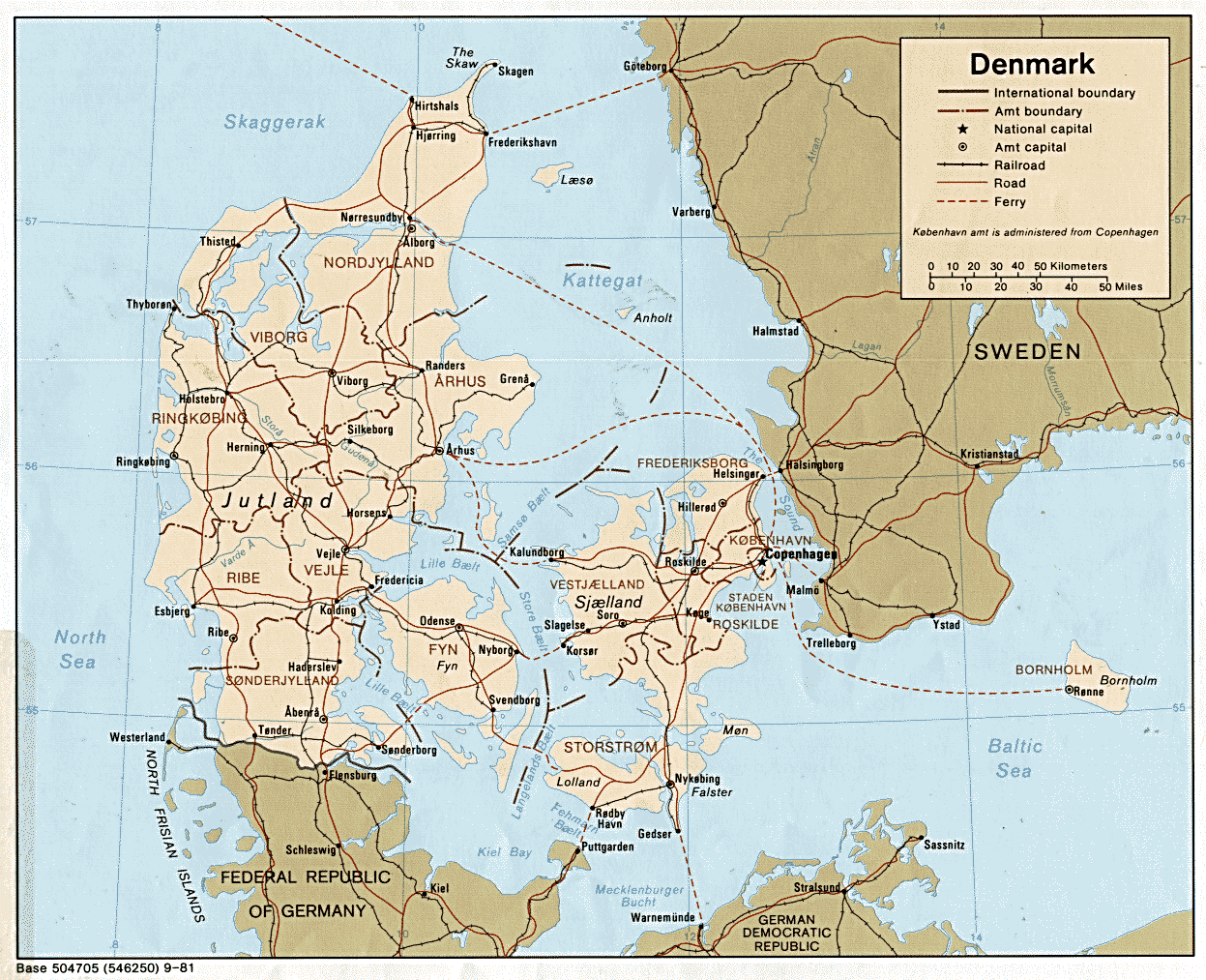
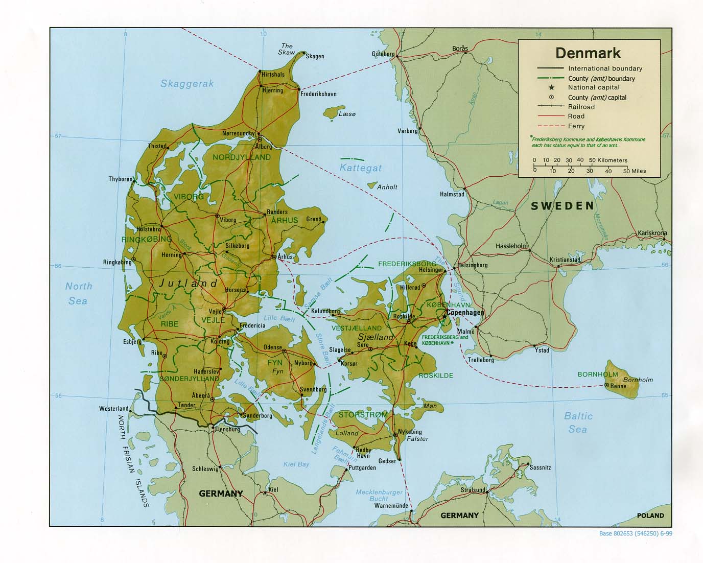
http://www.lib.utexas.edu/maps/europe/denmark.gif
^are the real borders
or this:
http://www.lib.utexas.edu/maps/europe/denmark_rel99.jpg
i hope its enough
Posted:
Wed Mar 07, 2007 5:15 pmby Qwert
Of course, we have Nederland, Germany,England map, and my opinion its to have all European country map, if these posible.
Posted:
Wed Mar 07, 2007 5:18 pmby Wisse
yeah if rev kyle does something about france we have that one
bad speler is nearly finisht with liberia then we have already much european countrys
Posted:
Wed Mar 07, 2007 9:03 pmby Mr Tumbler
2 concrete suggestions!
Suggestion 1:

Regions:
NORDJYLLAND (Orange) - 2
MIDTJYLLAND (Blue) - 7
SYDDANMARK (Green) - 3
FYN (Brown) - 5
SJAELLAND (Purple) - 5
HOVEDSTADEN (Yellow) - 2
Suggestion 2:

NORDJYLLAND (Orange) - 2
MIDTJYLLAND (Blue) - 7
SYDDANMARK (Green) - 3
FYN (Brown) - 5
SJAELLAND (Purple) - 5
STORSTROM (Yellow) - 2
Please any danes! What about the naming of the regions, the divisions, the connections etc? I'm doing my very best, but I might do mistakes.
Also, I have used the danish names for everything, but replaced all danish ø's to simple o, and all danish æ's to ae. Is this a good replacement strategy.
Notes:
There are now 36 "countries"
There is an error in the map. Falster is connected to Vordingborg, missed a re-coloring of that connection.
The suggested bonuses by Nokura I think are too small. I think we need rather big bonuses, at the level suggested here, or only slightly less.
Posted:
Thu Mar 08, 2007 4:01 amby boberz
i like this idea a lot the whole map need to be lighter though
edit: (to the below post) yes thats exactly what i mean more appealing that way, could also consider the flag, title and other generally pretty stuff
Posted:
Thu Mar 08, 2007 10:26 amby Mr Tumbler
What do you mean with lighter? Lighter colors on the sea, the countries etc?
Posted:
Thu Mar 08, 2007 10:58 amby santon836
whole this stuff, so everything.
I don't like the yellow you used.
You can't read the text well on it.
Posted:
Thu Mar 08, 2007 11:16 amby Molacole
you might want to move bornholm over to the rest of the map so it isn't isolated so much. It'll give you a lot more room to work with.
change the colors too please.
Posted:
Thu Mar 08, 2007 1:03 pmby Samus
Okay, here's what I see:
Orange: 6 territories, 3 borders all to 1 region
Blue: 9 territories, 8 borders to 3 regions
Green: 6 territories, 3 borders to 2 regions
Brown: 5 territories, 5 borders to 2-3 regions
Suggestion 1 Purple: 7 territories, 4 borders to 3 regions
Suggestion 2 Purple: 7 territories, 3 borders to 3 regions
Suggestion 1 Yellow: 3 territories, 3 borders to 1 region
Suggestion 2 Yellow: 3 territories, 3 borders to 2 regions
Orange needs a bonus of +3.
Blue is just totally indefensible. It has 9 territories and you have to defend 8 of them! If you've got that many armies you should have won the game already. You need to eliminate the connections from Holbaek to Arhus and Randers, and put up some sort of mountain range or something dividing Ringkjobing and Ribe. Blue still has 6 borders and almost certainly can't be held on its own, but if you own Orange or Green it is now possible to expand out in that direction without leaving yourself totally exposed.
Green is fine, bonus of +3 is fine.
Brown needs one connection removed from Als (I think that's right, can't really read it), either from Svendborg or Aero, one of the two. I think it's still hard to defend, but bonus of +5 is a lot for only 5 territories.
Suggestion 1 Purple is fine, bonus of +5 is fine.
Suggestion 2 Purple has 1 less border, so it needs a bonus of +4.
Suggestion 1 Yellow needs the connection between Bornholm and Roskilde removed so it only has 2 borders, bonus of +2 is fine.
Suggestion 2 Yellow needs the connection between Falster and Vordingborg removed (this one is blue, maybe you intended to remove it?), bonus of +2 is fine.
Posted:
Thu Mar 08, 2007 5:18 pmby Mr Tumbler
Ok, tried to remove some connections. To be true to the Danish country, I have kept more connections than was suggested. I move Bornholm closer. I made it more clear where there are connections, and where there aren't.

Suggestion:
Orange - 3
Blue - 7
Green - 3
Grey - 5
Purple - 5
Yellow - 2
Posted:
Thu Mar 08, 2007 7:27 pmby AndyDufresne
Right now, the gameplay looks very basic, and very much like this +.
It looks like you can attack up and down or side to side. It doesn't seem to offer so much with the current number of attack routes and such.
--Andy
Posted:
Thu Mar 08, 2007 8:04 pmby KEYOGI
Is there much point in a Denmark map? The country's already being represented as part of the Scandinavia map?
Posted:
Thu Mar 08, 2007 11:04 pmby Pro_Snowboarder
the scandinavia map is SCANDINAVIA, not DENMARK. Thats like saying there is no point to have Europe as a map, its being represented in the classic map, and the World 2.0 map. Or a Germany map, because its being represented in the Europe map.
Posted:
Fri Mar 09, 2007 5:43 amby boberz
wow one extreme to the other super dark to super light, night sky to babies cradle. Somewher ein between i think
to try and solve gameplay isue remove a few more connections and make the brown continent more easy to hold allowing armies to be built up near the centre possibly add a new connection between yellow continent and orange make gameplay more rounded
make it smaller
Posted:
Fri Mar 09, 2007 12:51 pmby KEYOGI
Pro_Snowboarder wrote:the scandinavia map is SCANDINAVIA, not DENMARK. Thats like saying there is no point to have Europe as a map, its being represented in the classic map, and the World 2.0 map. Or a Germany map, because its being represented in the Europe map.
That's taking it a bit far. I'm just not sure Denmark is the most appealing place for a map all on it's own. It's kind of stuck in the middle there though and would be hard to incorporate into another map of a larger area. Perhaps if it's given some sort of Viking twist to spice it up it would help?
Posted:
Fri Mar 09, 2007 5:17 pmby Mr Tumbler
boberz wrote:wow one extreme to the other super dark to super light, night sky to babies cradle. Somewher ein between i think
to try and solve gameplay isue remove a few more connections and make the brown continent more easy to hold allowing armies to be built up near the centre possibly add a new connection between yellow continent and orange make gameplay more rounded
make it smaller
He, will try solve the color issues.

I will definitely not connect yellow with orange, that will destroy those 2 "ends" of the game, which is an interesting and unique part of the map.
What should I make smaller? The picture of course will become smaller, will post lo-res versions hence forth and not the hi-res working map.
KEYOGI wrote:That's taking it a bit far. I'm just not sure Denmark is the most appealing place for a map all on it's own. It's kind of stuck in the middle there though and would be hard to incorporate into another map of a larger area. Perhaps if it's given some sort of Viking twist to spice it up it would help?
A Viking twist, or a danish happy red twist will make things more interesting, good idea.
Some are concerned about the amount of borders. But if you look at many maps: British Isles, Ireland, Australia, Indochina etc, they have even more borders. But it is interesting in itself. I don't wish to change the real danish geography, maybe remove some ferry connections.
The real problem is the blue area. It's almost as bad as the central part of the European map. It doesn't help to split it in west and east either.