Vic?
I have to do what Vic says or he'll go on a tirade against me...
Waiting patiently.
[Abandoned] Mississippi Magnolia St
Moderator: Cartographers
Re: Mississippi Magnolia State Map - [June 7, '12] - Page 14
![]() by vaughn03 on Tue Jun 12, 2012 11:08 pm
by vaughn03 on Tue Jun 12, 2012 11:08 pm
-

 vaughn03
- Posts: 145
- Joined: Thu Mar 17, 2011 8:25 pm
- Location: Kalifornia


Re: Mississippi Magnolia State Map - [June 7, '12] - Page 14
![]() by VicFontaine on Wed Jun 13, 2012 8:44 am
by VicFontaine on Wed Jun 13, 2012 8:44 am
vaughn03 wrote:Vic?
I have to do what Vic says or he'll go on a tirade against me...
Waiting patiently.
You tell me when we can get to work by emailing me. We don't need to decide that on the forum thread.
"It is a good day to die."
-

VicFontaine
- Posts: 372
- Joined: Sat Oct 02, 2010 7:34 pm
- Location: The Dominion


Re: Mississippi Magnolia State Map - [June 7, '12] - Page 14
![]() by WILLIAMS5232 on Wed Jun 13, 2012 9:52 pm
by WILLIAMS5232 on Wed Jun 13, 2012 9:52 pm
nolefan5311 wrote:
- Click image to enlarge.
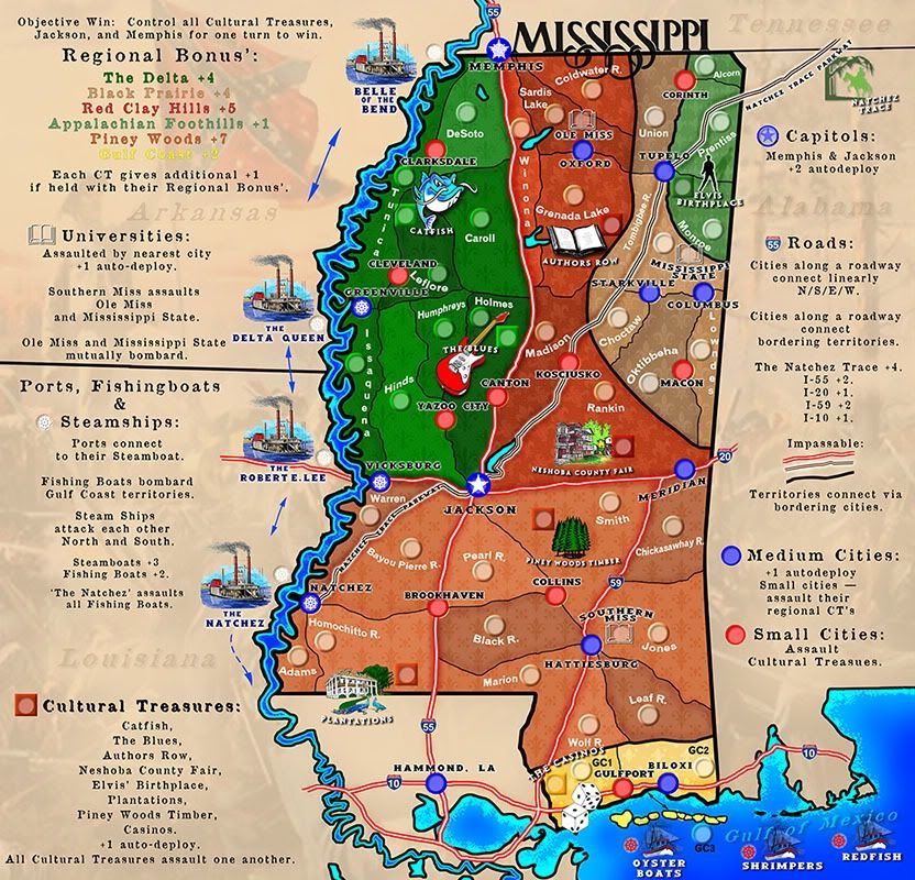
- And again, I have to suggest to get rid of the road bonuses outside of the Natchez Trace completely. Like I said previously, nothing about them is unique to Mississippi and the only serve to add an unnecessary complication.
vic, i got to go along with this, i know you may not like it now, but when the map is done and complete i think even you can appreciate this change.
i'm basically in agreement with everything nolefan says, but to me, if you were going to do anything this is the big one that i would do.
no, we're not in cahoots, in case you were wondering.

-

WILLIAMS5232
- Posts: 1838
- Joined: Sun Aug 16, 2009 4:22 pm
- Location: houston texas


Re: Mississippi Magnolia State Map
![]() by isaiah40 on Thu Jun 14, 2012 8:44 am
by isaiah40 on Thu Jun 14, 2012 8:44 am
Vic in response to this:
I said this back on Mar 4:
Please notice that I didn't say that I would approve your "supersize" application, i said that I would take another loo and go from there. That being said, you still have plenty of room on the sides to make the gameplay instructions clear and concise. So your "supersize " application is denied and you will need to keep this at the standard sizes of 800x840 for the large and 630x600 for the small.
VicFontaine wrote:Please make this supersized. You have no real quality objections not to and had already told us you would. We continue to get complaints about how "crowded" this looks. We've continued to say, "Make it supersize and it won't be crowded."
I said this back on Mar 4:
isaiah40 wrote:I've looked over this a few times now to figure out the best way to rearrange things so you won't need to go so big. Right now you can crop the height down from the 1024 to 1000. So if you can do that and update your supersize application with what sizes you are looking - both small and large- then I will take another look and go from there.
Please notice that I didn't say that I would approve your "supersize" application, i said that I would take another loo and go from there. That being said, you still have plenty of room on the sides to make the gameplay instructions clear and concise. So your "supersize " application is denied and you will need to keep this at the standard sizes of 800x840 for the large and 630x600 for the small.
-
isaiah40
- Posts: 3990
- Joined: Mon Aug 27, 2007 7:14 pm


Re: Mississippi Magnolia State Map - [June 7, '12] - Page 14
![]() by vaughn03 on Thu Jun 14, 2012 10:53 am
by vaughn03 on Thu Jun 14, 2012 10:53 am
Why aren't the dimensions proportional? We will need to adjust for the second size?
Who's the Big Cheese on sizes again? I'd like to find the answers to this... The whole thing makes no sense to me - the difference between 840 and 630 isn't worth doing - (the computer can zoom it just as effectively). CC should have LARGE map for desktops and small map for laptops and smaller... This is really a much bigger issue than the Miss Map, IMHO.
Who's the Big Cheese on sizes again? I'd like to find the answers to this... The whole thing makes no sense to me - the difference between 840 and 630 isn't worth doing - (the computer can zoom it just as effectively). CC should have LARGE map for desktops and small map for laptops and smaller... This is really a much bigger issue than the Miss Map, IMHO.
-
vaughn03
- Posts: 145
- Joined: Thu Mar 17, 2011 8:25 pm
- Location: Kalifornia
Re: Mississippi Magnolia State Map - [June 7, '12] - Page 14
![]() by koontz1973 on Thu Jun 14, 2012 1:29 pm
by koontz1973 on Thu Jun 14, 2012 1:29 pm
vaughn03 wrote:Why aren't the dimensions proportional?
They are. A scaled down layer of 840/800 comes to 630/600.
We will need to adjust for the second size?
No you will not.
Who's the Big Cheese on sizes again? I'd like to find the answers to this... The whole thing makes no sense to me - the difference between 840 and 630 isn't worth doing - (the computer can zoom it just as effectively). CC should have LARGE map for desktops and small map for laptops and smaller... This is really a much bigger issue than the Miss Map, IMHO.
The big boss man lack.
This issue with size is not a major issue with this map. Right now, the issue that needs to be dealt with is game play. A lot of what is on the map (has already been pointed out so will out go there again) may not even end up in the final map. You have already proven that the map can come down to 840/800 so scaling it down further is not a big deal. Just look at the left and right side of the map, a lot of space has been completely wasted. Look at some of the other maps on the site. Made before SS came around. A lot have more territs with complicated GP (Stalingrad, Rorke's Drift) and they have managed to fit it all in.
VicFontaine wrote:We continue to get complaints about how "crowded" this looks.
Where are these complaints?
If the map is too crowded, then some of the GP elements may need to come out or change. This is your choice now Vic and Vaughn. This map has elements that could make for a great map so please do not stop, but please cut out the "let us have supersize" talk. It is getting you no where.
Give yourself some more room to play with.
Catfish, blues guitar, plantations etc are all very large. Nice graphics but large. Make these half the size they are. Same goes for the steam boats and oyster boats.
You have a lot of roads that are impassable. Why not use one type instead of 3 for these. That gets more space.
These 3 things will not only give you more space but take out the cluttered look you have. You do not need to go larger, if anything, you need to make things smaller.
Hope you continue with it.

-

koontz1973
- Posts: 6960
- Joined: Thu Jan 01, 2009 10:57 am


Re: Mississippi Magnolia State Map - [June 7, '12] - Page 14
![]() by thenobodies80 on Thu Jun 14, 2012 6:12 pm
by thenobodies80 on Thu Jun 14, 2012 6:12 pm
Ok, this is the official final say on the size of this map.
Like isaiah has said the map should stay easily within the standard size limits, so the large must be max 840x800 px (wxh) and the small must be max 630x600 (wxh).
To do that, you need first to use the space more wisely, if you need to cut something, cut something...then draw your large map within the standard size limits, when you will reach the graphics stage scale down your image to a size that is within the small map limits, both images don't have to be exactly those sizes, just those are the limits you have to consider and respect.
I know that big/small sizes are not consistent, those sizes were decided in past and probably we will change them in the next future to create more consistence, but for now please follow the guidelines and develop a map that respect "the bold/underlined part" of the above quoted text
Thanks
Nobodies
Like isaiah has said the map should stay easily within the standard size limits, so the large must be max 840x800 px (wxh) and the small must be max 630x600 (wxh).
To do that, you need first to use the space more wisely, if you need to cut something, cut something...then draw your large map within the standard size limits, when you will reach the graphics stage scale down your image to a size that is within the small map limits, both images don't have to be exactly those sizes, just those are the limits you have to consider and respect.
guidelines wrote:Map Sizes - Each map must eventually be submitted in two sizes. The 'large' map may be up to 840px wide and 800px high. The small map may be up to 630px wide and 600px high. Mapmakers are encouraged to make their 'large' maps smaller than the maximum size limits when possible. The 'large' map must be noticeably larger than the 'small' map; 9% larger is required but 33.3% (1/3) is recommended. The majority of mapmakers begin working on their large image; although it is worth ensuring that everything will remain clear and legible on the small image relatively early during development.
I know that big/small sizes are not consistent, those sizes were decided in past and probably we will change them in the next future to create more consistence, but for now please follow the guidelines and develop a map that respect "the bold/underlined part" of the above quoted text
Thanks
Nobodies
-

thenobodies80
- Posts: 5400
- Joined: Wed Sep 05, 2007 4:30 am
- Location: Milan


Re: Mississippi Magnolia State Map - [June 7, '12] - Page 14
![]() by DoomYoshi on Thu Jun 14, 2012 6:42 pm
by DoomYoshi on Thu Jun 14, 2012 6:42 pm
The road bonuses do suck. They don't all suck, but the I-10 does, it makes the gulf so much more valuable. Since you can't just get rid of the I-10 though, you should just get rid of all the road bonuses.
░▒▒▓▓▓▒▒░
-

DoomYoshi
- Posts: 10715
- Joined: Tue Nov 16, 2010 9:30 pm
- Location: Niu York, Ukraine


Re: Mississippi Magnolia State Map - [June 7, '12] - Page 14
![]() by vaughn03 on Thu Jun 14, 2012 8:45 pm
by vaughn03 on Thu Jun 14, 2012 8:45 pm
Sorry for confusion. You wrote:
'So your "supersize " application is denied and you will need to keep this at the standard sizes of 800x840 for the large and 630x600 for the small.'
Not proportioned... (numbers switched)
This is Vic's map - I merely offered to help. Will move/reduce/eliminate as instructed when you come to a consensus.
Thanks.
-
vaughn03
- Posts: 145
- Joined: Thu Mar 17, 2011 8:25 pm
- Location: Kalifornia
Re: Mississippi Magnolia State Map - [June 7, '12] - Page 14
![]() by isaiah40 on Fri Jun 15, 2012 12:44 am
by isaiah40 on Fri Jun 15, 2012 12:44 am
vaughn03 wrote:Sorry for confusion. You wrote:
'So your "supersize " application is denied and you will need to keep this at the standard sizes of 800x840 for the large and 630x600 for the small.'
Not proportioned... (numbers switched)
This is Vic's map - I merely offered to help. Will move/reduce/eliminate as instructed when you come to a consensus.
Thanks.
Yes sorry I meant 840x800 for the large. Now they are proportional!
-
isaiah40
- Posts: 3990
- Joined: Mon Aug 27, 2007 7:14 pm
Re: Mississippi Magnolia State Map - [June 7, '12] - Page 14
![]() by nolefan5311 on Sat Jul 07, 2012 7:40 pm
by nolefan5311 on Sat Jul 07, 2012 7:40 pm
Moved to the Recycling Bin
It would appear that development of this map has stalled. If the mapmaker wants to continue with the map, then one of the Foundry Moderators will be able to help put the thread back into the Foundry system, after an update has been made.
It would appear that development of this map has stalled. If the mapmaker wants to continue with the map, then one of the Foundry Moderators will be able to help put the thread back into the Foundry system, after an update has been made.
-

nolefan5311
- Posts: 1768
- Joined: Mon Nov 22, 2010 11:51 am
- Location: Florida


Who is online
Users browsing this forum: No registered users
|
|||||||
| Conquer Club is not associated with RISK online in any way. Copyright © 2006-2024 by Big Wham LLC | |||||||