Page 2 of 9

Re: Mississippi Magnolia State Map

PostPosted: Thu Feb 16, 2012 9:46 pm
by WILLIAMS5232
VicFontaine wrote:
WILLIAMS5232 wrote:dang vic, i love this map. it helps too that i'm from mississippi. a great state too i might add. although i deserted it when i turned 18, i know i'll be back one day to die there. and nice touch on all the histories.

do you have an image shack account?


I do have an IS account. I think it's VicFontaine, still. Or Vicfontaine80 or something like that.


well load your image to there and you can put it in the OP like normal. it'd be so much easier to read.

Re: Mississippi Magnolia State Map

PostPosted: Thu Feb 23, 2012 7:31 pm
by VicFontaine
All you guys who have expressed interest in this map:

The "Design Team" is so close to being done with it—it looks fantastic. We are within weeks or days (if we roll dem sixes) of posting the image and asking it to be moved to the "Draft" stage.

Can't wait to share what we've been working on and getting feedback, defending gameplay, making slight alterations as per your instructions. We're doing a "rush" job just to get it up, so the graphics aren't finalized or perfect, but we're laying the groundwork as best we can to ensure no major changes would be necessary to play as is. Major changes COULD be made, but they wouldn't be necessary.

KEEP WATCHING GUYS!

Re: Mississippi Magnolia State Map

PostPosted: Fri Feb 24, 2012 7:55 am
by DiM
VicFontaine wrote:The "Design Team" is so close to being done with it—it looks fantastic.


i don't want to be a party pooper but is this map really happening? i have no major interest in mississippi but i do have one on your start trek map. what i'm worried about is that on each map it's the same story. months after months you keep saying you're working and working and yet you don't have even a crude draft. nothing.
you're getting the hopes up for many people and you're building hype with words like "it looks fantastic" and yet nobody has seen anything in months.

if you say you're working on it just show us your work regardless of what stage it is.
there's nothing to lose if you do this. you have only advantages by posting here. if your draft looks bad or if it has flaws then people will promptly tell you what to change and how to change. there's no point in working for months on an image only to post it and get trashed as soon as you do and waste all that work.

Re: Mississippi Magnolia State Map

PostPosted: Fri Feb 24, 2012 9:26 am
by VicFontaine
DiM wrote:
VicFontaine wrote:The "Design Team" is so close to being done with it—it looks fantastic.


i don't want to be a party pooper but is this map really happening? i have no major interest in mississippi but i do have one on your start trek map. what i'm worried about is that on each map it's the same story. months after months you keep saying you're working and working and yet you don't have even a crude draft. nothing.
you're getting the hopes up for many people and you're building hype with words like "it looks fantastic" and yet nobody has seen anything in months.

if you say you're working on it just show us your work regardless of what stage it is.
there's nothing to lose if you do this. you have only advantages by posting here. if your draft looks bad or if it has flaws then people will promptly tell you what to change and how to change. there's no point in working for months on an image only to post it and get trashed as soon as you do and waste all that work.


I quit with the Star Trek map because I was told, while working on this map, that hand-drawn submissions were a waste of my time. I don't know graphic design on computers.

This one's coming. I'm not going to post it until we've gotten the graphics done. This isn't an issue of "tweaking" per se, but in making sure all the graphics needed for it to be a complete map are there.

As for "each map"...there's only been two prior. One was Hiroshima, which is (still) a great map. Unfortunately, it was vetoed. The other is Trek, and until I find someone willing to use GIMP or some other program for me, since I can't do it, it's going no where. If you want to start the process, DIM, that's great. Send me a PM in my inbox and we can get to work on it. I can send you, today, my hand-drawn rough drafts and you can get started.

If anyone wants to see the MS Mag map AS IT CURRENTLY STANDS IN DEVELOPMENT, go here:

http://s1154.photobucket.com/albums/p537/vicfontaine1/?action=view&current=Draft.jpg

I'm not posting that image on the first posting of this thread, however, because we don't have all the necessary elements of the map even on the board yet, as I mentioned previously. Anywhere from 40-100 emails are sent each week between me (acting as Art Director, I guess) and the Designer. He's doing everything he can, as fast as he can, and is doing a fantastic job. Please be patient folks. The map will be worth it for its gameplay alone, much less its graphics.

Re: Mississippi Magnolia State Map

PostPosted: Fri Feb 24, 2012 10:03 am
by natty dread
DiM wrote:if you say you're working on it just show us your work regardless of what stage it is.
there's nothing to lose if you do this. you have only advantages by posting here.


This. Is entirely correct, is what I'm saying.

As a first time mapmaker, it's best to post whatever you have as soon as you have a working draft. You're not going to get your map completed in 1, 2, 5 or 10 versions. Feedback is critical to success, for new and old mapmakers alike, and if you never post your map image you won't get feedback.

Furthermore, the longer your thread is without updates, the less interest people will have in it - you need to keep posting updates to keep people interested in your map project.

Re: Mississippi Magnolia State Map

PostPosted: Fri Feb 24, 2012 10:41 am
by VicFontaine
Even if the map doesn't even have all the gameplay elements? In other words: if only 80% of the gameplay elements—not talking about graphics here—are there, I should post it anyway? Okie dokie.

Lemme see how I can remember to do that here...eh....uh...

Re: Mississippi Magnolia State Map

PostPosted: Fri Feb 24, 2012 10:55 am
by DiM
VicFontaine wrote:Even if the map doesn't even have all the gameplay elements? In other words: if only 80% of the gameplay elements—not talking about graphics here—are there, I should post it anyway? Okie dokie.

Lemme see how I can remember to do that here...eh....uh...


i've posted anywhere from hand drawn horrible looking drafts with no names or bonuses to almost 99% done maps. either time i received feedback and this is what counts.
no matter what stage you're in, feedback will help you improve the map.

Re: Mississippi Magnolia State Map

PostPosted: Fri Feb 24, 2012 11:01 am
by VicFontaine
POSTED THE UPDATED IMAGE!

PLEASE SEE THE FIRST POST OF THIS THREAD ON PAGE 1, then return for comments.

Re: Mississippi Magnolia State Map

PostPosted: Fri Feb 24, 2012 11:15 am
by Oneyed
VicFontaine wrote:POSTED THE UPDATED IMAGE!

PLEASE SEE THE FIRST POST OF THIS THREAD ON PAGE 1, then return for comments.


I like it, it loose hand draw look, but I like it.

what more can I say? everything what must be done you have in your first post... ;)

VicFontaine wrote:WHAT STILL MUST BE DONE:
1) Some fonts are hard to read.
2) Some cultural treasures' images are not on the map next to their names, which are on the map.
3) Some cities are in the wrong place.
4) There is no legend/explanation of gameplay, nor are the connecting dotted lines showing attack paths that are needed in some areas (e.g., Steamboats, cities connecting to their universities)
5) The universities are not on the map, though Ole Miss is represented by a Cap (which will change)
6) There is one missing highway around the Oxford/Ole Miss area. It's absence joins two named territories that need to be divided (highways are all the black lines that act as territory dividers. Interstates are obvious and not the same as highways.)
7) Some of the coloring is still a tad off.
8) I'd still like one more Cultural Treasure, "Hunting," on the map. It has neither name nor image at present.
9) The possibility of an objective win: I like this. Don't know what it would be, but perhaps holding the Universities or all the Cultural treasures, plus the Capitol of Jackson.


Oneyed

Re: Mississippi Magnolia State Map

PostPosted: Fri Feb 24, 2012 12:09 pm
by natty dread
Ok, not bad.

But you can (and should) post the image in both ends of the thread, that way people who're following the thread won't have to scroll all the way back to page 1...

Re: Mississippi Magnolia State Map

PostPosted: Sun Feb 26, 2012 8:49 am
by WILLIAMS5232
the font under the steamboats are hard to read. and being a red/green color blind person i can say the ones on the coast are near impossible to do so. it would help to change the color on those, and maybe make the flared edges a bit bigger on all of them.

edit; also it looks as though Florida is gone. not sure if that's intentional but Mississippians and Floridians are pretty good friends. you may want to include them as well. :lol:

what is black r. ?

Re: Mississippi Magnolia State Map

PostPosted: Sun Feb 26, 2012 11:07 am
by natty dread
Winona is also a really uncomfortable shape for a territory... I think you should make it slightly larger so it's at least clearer what it borders.

Re: Mississippi Magnolia State Map

PostPosted: Sun Feb 26, 2012 3:27 pm
by VicFontaine
WILLIAMS5232 wrote:the font under the steamboats are hard to read. and being a red/green color blind person i can say the ones on the coast are near impossible to do so. it would help to change the color on those, and maybe make the flared edges a bit bigger on all of them.

edit; also it looks as though Florida is gone. not sure if that's intentional but Mississippians and Floridians are pretty good friends. you may want to include them as well. :lol:

what is black r. ?


This is one reason I didn't want to post anything yet. The rules of the Foundry stipulate that I have to respond to everything. Williams is 100% right on everything except the Florida comment. Dem Floridians is just fake-southerners lol

But seriously: the day I posted that image, we already were addressing, via Skype, all the issues he raised. We're adding "textures" for the colorblind, and we're making gameplay better on terts like "Winona" so it is, yes, more playable.

"Black R.," and all terts labeled with a "R.," next to it, are RIVER terts. Because Mississippi has great rivers and great counties, I blended both for naming purposes. Some terts, like my own County of "Rankin," are, more-or-less relative to that counties' location in reality. Same with the rivers. "Black R.," is "Black River" rather than a county name. That is, the actual waterway "Black River" flows through that general location in Mississippi.

Re: Mississippi Magnolia State Map

PostPosted: Sun Feb 26, 2012 3:30 pm
by VicFontaine
natty dread wrote:Winona is also a really uncomfortable shape for a territory... I think you should make it slightly larger so it's at least clearer what it borders.


Answered in my immediately preceding comment about Williams' great suggestions. We've already corrected it. It is still elongated (perhaps your "uncomfortable shape" but we have made it clearer where it is and what it borders.

Thanks, ND! We noticed this problem, too. Glad to see that problems, so far, are noticeable by all. Makes things easier.

Re: Mississippi Magnolia State Map

PostPosted: Sun Feb 26, 2012 5:30 pm
by WILLIAMS5232
VicFontaine wrote:"Black R.," and all terts labeled with a "R.," next to it, are RIVER terts. Because Mississippi has great rivers and great counties, I blended both for naming purposes. Some terts, like my own County of "Rankin," are, more-or-less relative to that counties' location in reality. Same with the rivers. "Black R.," is "Black River" rather than a county name. That is, the actual waterway "Black River" flows through that general location in Mississippi.


oh, i was assuming you were talking about "black creek" and was going to be a stickler and suggest you make it that. after further research though, i've learned there is actually a "black river" in ms as well. :oops:

Re: Mississippi Magnolia State Map

PostPosted: Sun Feb 26, 2012 9:30 pm
by VicFontaine
WILLIAMS5232 wrote:
VicFontaine wrote:"Black R.," and all terts labeled with a "R.," next to it, are RIVER terts. Because Mississippi has great rivers and great counties, I blended both for naming purposes. Some terts, like my own County of "Rankin," are, more-or-less relative to that counties' location in reality. Same with the rivers. "Black R.," is "Black River" rather than a county name. That is, the actual waterway "Black River" flows through that general location in Mississippi.


oh, i was assuming you were talking about "black creek" and was going to be a stickler and suggest you make it that. after further research though, i've learned there is actually a "black river" in ms as well. :oops:


You're one of the ones Haley Barbour booted from the state, no doubt. SHEESH. :)

Yes, there is a Black River.

Re: Mississippi Magnolia State Map

PostPosted: Sun Feb 26, 2012 10:51 pm
by VicFontaine
UPDATE AS OF FEBRUARY 26, 2012.

Image

STILL TO DO: (probably in order of importance):

1) Textures for the colorblind in keeping with the theme, which we're still deciding. I'm leaning towards "history," i.e., Civil War images, Indian images (that would be, depending on how "PC" you are: "First-Peoples" or "Native Americans"), etc. Will discuss with the Designer before we make that certain.
2) A few things moved around and clarified, such as the Steamboats' attack routes clarified (they go north and south both, not just south, in attack)
3) Some graphics are only there until we decide something better (again, like the Steamboats' attack routes)
4) We're considering another Cultural Treasure that has to do with the Indians, or with "hunting," the latter being listed in the legend under "Cultural Treasures" but found no where on the map.
5) Some graphics aren't there yet, but aren't necessary for gameplay.

Re: Mississippi Magnolia State Map

PostPosted: Sun Feb 26, 2012 11:13 pm
by WILLIAMS5232
VicFontaine wrote:
WILLIAMS5232 wrote:
VicFontaine wrote:"Black R.," and all terts labeled with a "R.," next to it, are RIVER terts. Because Mississippi has great rivers and great counties, I blended both for naming purposes. Some terts, like my own County of "Rankin," are, more-or-less relative to that counties' location in reality. Same with the rivers. "Black R.," is "Black River" rather than a county name. That is, the actual waterway "Black River" flows through that general location in Mississippi.


oh, i was assuming you were talking about "black creek" and was going to be a stickler and suggest you make it that. after further research though, i've learned there is actually a "black river" in ms as well. :oops:


You're one of the ones Haley Barbour booted from the state, no doubt. SHEESH. :)

Yes, there is a Black River.


easy there vic, if you want to get technical the black river runs into the mississippi at vicksburg. so for me to think that you put black river in black creeks general location is not too far off. and also since we're on topic, you may also note that the although the leaf river and the pascagula river are the same, where you have it placed would be more of the pascagula rivers location. it's just that's the areas i'm from. when i go home i still float the black and red creeks and fish in the pascagula river swamp. it's all the same vicinity. i'm from mchenry area. near wiggins. i know they have tvs and all in jackson, so i would have figured you knew that. and dang, you got biloxi set up in moss point. biloxi and gulfport actually border each other. :roll:

you must be one of the ones haley barbour kept and educated. :lol: =D>

i'm just kidding. i was educated there too. don't take it so hard :evil:

Re: Mississippi Magnolia State Map

PostPosted: Sun Feb 26, 2012 11:21 pm
by VicFontaine
WILLIAMS5232 wrote:
VicFontaine wrote:
WILLIAMS5232 wrote:
VicFontaine wrote:"Black R.," and all terts labeled with a "R.," next to it, are RIVER terts. Because Mississippi has great rivers and great counties, I blended both for naming purposes. Some terts, like my own County of "Rankin," are, more-or-less relative to that counties' location in reality. Same with the rivers. "Black R.," is "Black River" rather than a county name. That is, the actual waterway "Black River" flows through that general location in Mississippi.


oh, i was assuming you were talking about "black creek" and was going to be a stickler and suggest you make it that. after further research though, i've learned there is actually a "black river" in ms as well. :oops:


You're one of the ones Haley Barbour booted from the state, no doubt. SHEESH. :)

Yes, there is a Black River.


easy there vic, if you want to get technical the black river runs into the mississippi at vicksburg. so for me to think that you put black river in black creeks general location is not too far off. and also since we're on topic, you may also note that the although the leaf river and the pascagula river are the same, where you have it placed would be more of the pascagula rivers location. it's just that's the areas i'm from. when i go home i still float the black and red creeks and fish in the pascagula river swamp. it's all the same vicinity. i'm from mchenry area. near wiggins. i know they have tvs and all in jackson, so i would have figured you knew that. and dang, you got biloxi set up in moss point. biloxi and gulfport actually border each other. :roll:

you must be one of the ones haley barbour kept and educated. :lol: =D>

i'm just kidding. i was educated there too. don't take it so hard :evil:


:lol: :lol: :lol:

Tru Dat! Naw mayun I jis gwine fer gameplaysall.

Translation: For sure, man. I've taken liberties with the landscape in a few places (Madison and Rankin counties are not at all like the map has them, but are smaller) for the sake of gameplay. As the foundry says, function beats form every time when designing a map. Had I put Biloxi and Gulfport where they really are, it'd be very hard to play the map. There are several instances of this.

Also, look at Winona. That still needs some tweaking...for gameplay's sake! Thanks SlickWilly!

Re: Mississippi Magnolia State Map

PostPosted: Mon Feb 27, 2012 3:08 am
by macbone
You know, for a Native America cultural treasure, you could use an Indian Mound, as in Faulkner's short story.

The Legend has a lot of text. It looks a bit cluttered there, but if I were playing the map, I'd want to know how everything worked. Could you make the information more concise?

I'm not sure which territories attack which other territories.

At first glance, it's difficult to tell which territories are the Cultural treasures (although the icons are helpful). Could you move the territory locations a bit so that they're closer to the treasures?

Re: Mississippi Magnolia State Map

PostPosted: Mon Feb 27, 2012 5:23 am
by Flapcake
macbone wrote:You know, for a Native America cultural treasure, you could use an Indian Mound, as in Faulkner's short story.

The Legend has a lot of text. It looks a bit cluttered there, but if I were playing the map, I'd want to know how everything worked. Could you make the information more concise?

I'm not sure which territories attack which other territories.

At first glance, it's difficult to tell which territories are the Cultural treasures (although the icons are helpful). Could you move the territory locations a bit so that they're closer to the treasures?


I need to add to this: you got some 4 way borders aswell, you will have to slice them apart to tell who can atack who.

Graphics looks uber ;)

Re: Mississippi Magnolia State Map

PostPosted: Mon Feb 27, 2012 9:08 am
by VicFontaine
macbone wrote:You know, for a Native America cultural treasure, you could use an Indian Mound, as in Faulkner's short story.


My thoughts exactly, but we can't find a good enough picture of an Indian Mound. It's still possible. The largest mound complex in North America were in Mississippi....

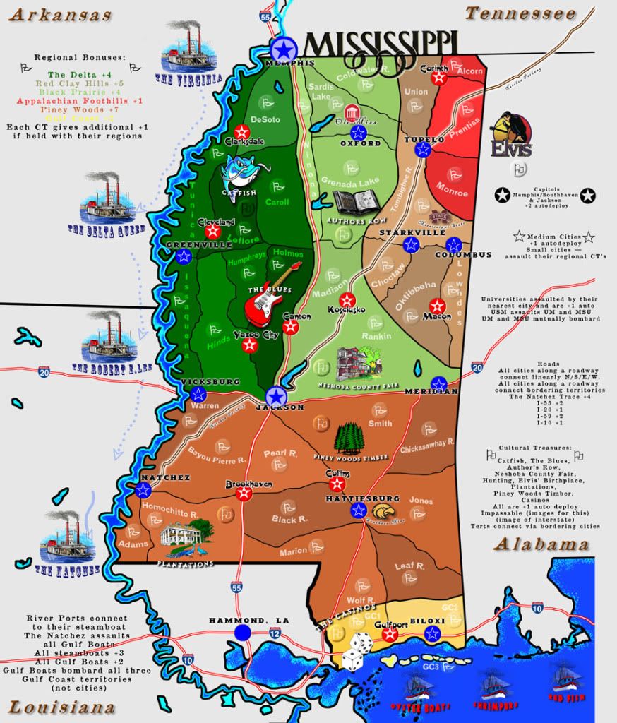
macbone wrote:The Legend has a lot of text. It looks a bit cluttered there, but if I were playing the map, I'd want to know how everything worked. Could you make the information more concise?


The grammar and presentation will be cleaned up, but since we're not trying to make a simple map (think more like Stalingrad), we won't sacrifice the diverse gameplay for simplicity. HOWEVER, we will endeavor to make it as simple, concise, and cogent as possible. Thanks, Mac!

macbone wrote:I'm not sure which territories attack which other territories.


Correct. I'll list this out for you, but we weren't trying to do that here as much, especially since the graphics can't support how the attacks work right now anyway. Gist is this:
1) All adjacent terts attack.
2) Terts are adjacent that are not separated by impassables (which include: interstates, regional bonus divisions)
3) Where impassables block access, cities provide access. So, cities that sit on an Interstate may, if you look, connect several territories (Memphis/Southhaven & Jackson are prime examples of this).
4) Other than this, all terts touch and attack one another.

macbone wrote:At first glance, it's difficult to tell which territories are the Cultural treasures (although the icons are helpful). Could you move the territory locations a bit so that they're closer to the treasures?


Definitely. We have hardly fine-tuned the placement of the army-markers.

Re: Mississippi Magnolia State Map

PostPosted: Mon Feb 27, 2012 9:12 am
by VicFontaine
Flapcake wrote:I need to add to this: you got some 4 way borders as well, you will have to slice them apart to tell who can attack whom.


I don't think this is necessary, actually. If they touch, they attack. If there are "four touching," even at the corners, they attack. Just as in reality: if you were standing at Four Corners in the US, you could attack any of the three spots upon which you do not stand.

Flapcake wrote:Graphics looks uber ;)


Thank you! We are trying very hard to make an aesthetically pleasing map that non-Mississippians will appreciate and want to play. The goal is have a blast of a game with varied, diverse, and multi-layered attack and defense structures while showcasing Mississippi. I think we're accomplishing that.

I just hope this map will soon be moved to the Draft folder where the real work may begin.

Re: Mississippi Magnolia State Map

PostPosted: Mon Feb 27, 2012 11:15 am
by natty dread
VicFontaine wrote:I don't think this is necessary, actually.


Actually, it is. 4-way borders are forbidden, as they are ambiguous to players. It's just not good gameplay design.

VicFontaine wrote:Just as in reality: if you were standing at Four Corners in the US, you could attack any of the three spots upon which you do not stand.


But, CC is not reality. It's a game. In reality battles are not decided by dice either, but in CC they are. You can't think of making CC maps in real world terms, gameplay clarity needs to come first always.

Re: Mississippi Magnolia State Map

PostPosted: Mon Feb 27, 2012 11:53 am
by VicFontaine
natty dread wrote:
VicFontaine wrote:I don't think this is necessary, actually.


Actually, it is. 4-way borders are forbidden, as they are ambiguous to players. It's just not good gameplay design.

VicFontaine wrote:Just as in reality: if you were standing at Four Corners in the US, you could attack any of the three spots upon which you do not stand.


But, CC is not reality. It's a game. In reality battles are not decided by dice either, but in CC they are. You can't think of making CC maps in real world terms, gameplay clarity needs to come first always.


Gotcha. Will do.