[Abandoned] - Scandinavia
Mod Note:Abandoned - If resurrected, this one must be checked again.

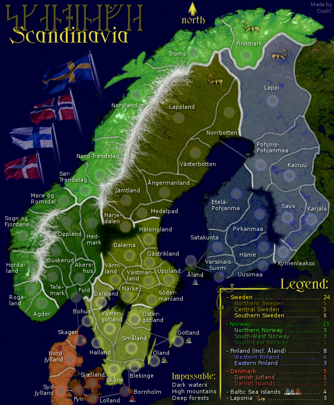
Hello everyone, I have created a map over the Nordics, what most people outside the region call Scandinavia (scandinavia is really just the mountain range). It was originally intended to be a pretty small map but instead went the opposite way since I wanted to include real regions and not made up fake ones. If you are wondering why Iceland is not included please see the discussion in the thread. I plan to finish this map myself (both graphics and XML) unless someone offer help.
Description:
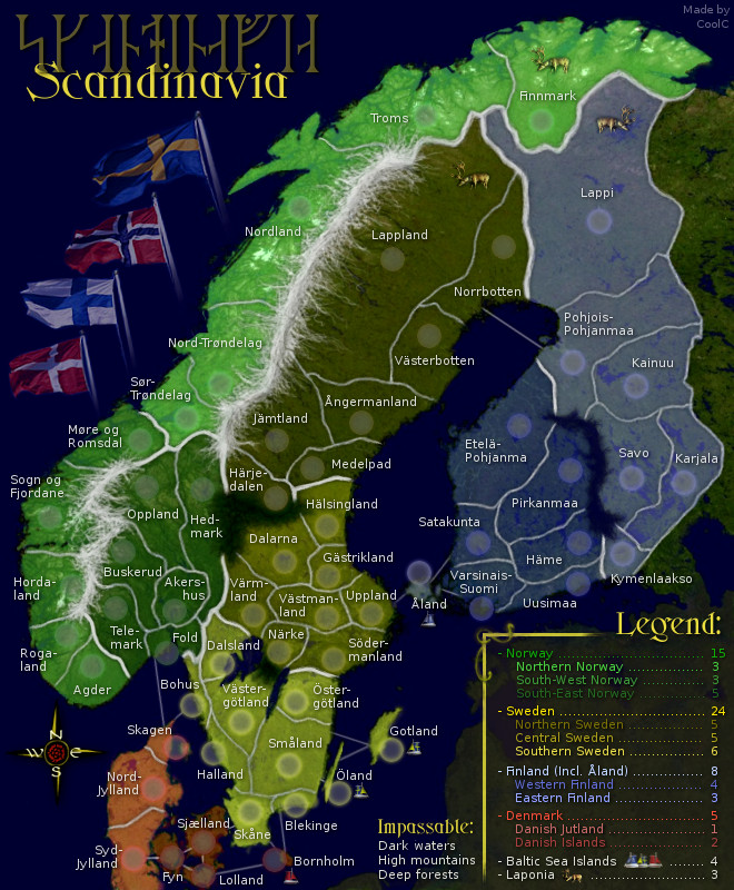
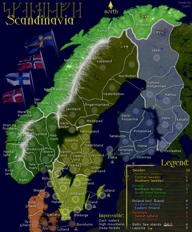
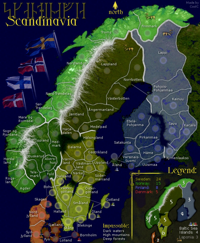
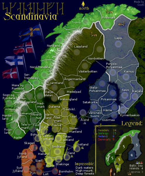
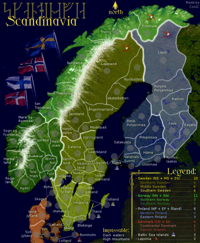
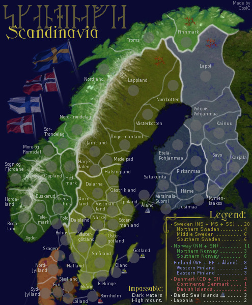
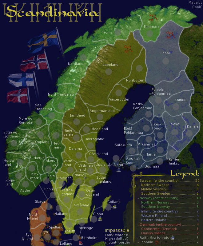
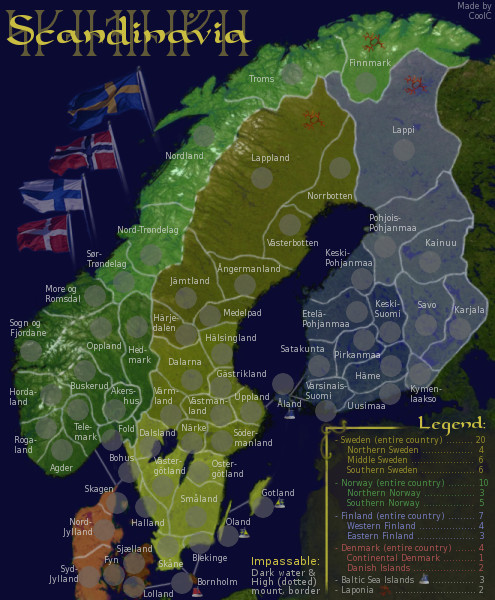
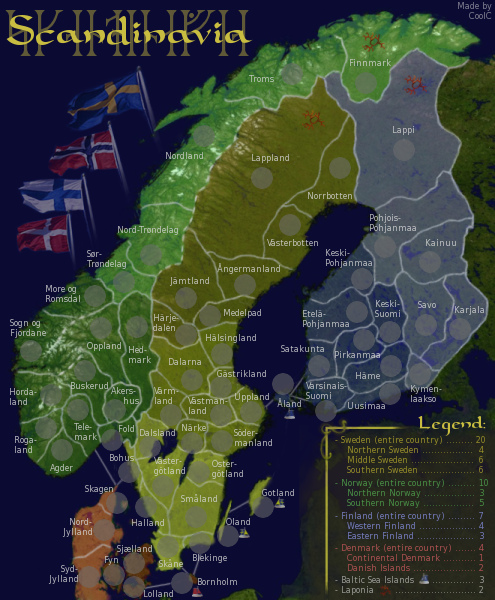
Currently we have 4 main "continents" which is the Scandinavian countries:
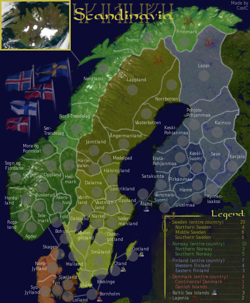
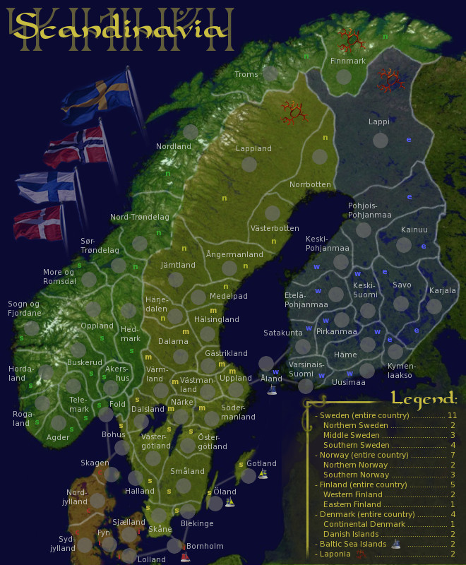
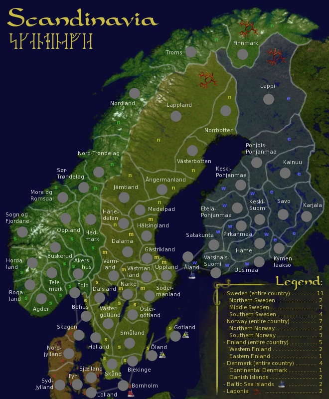
- Sweden, with 3 subcontinents of 10, 8 and 7 countries (25 total)
- Norway, with 3 subcontinents of 6, 5 and 5 countries (16 total)
- Finland, with 2 subcontinents of 6 countries each, plus neutral Åland (13 total)
- Denmark, with 2 subcontinents of 4 and 3 countries (7 total)
- Grand Total: 61 countries, 10 subcontinents, 4 continents
Two countries are designated to always start neutral: Åland + Bornholm
Bonuses are per subcontinent and continent. The continent bonus is including the subcontinent ones so it's -not- the continent + subcontinent.... in other words it's working exactly the same as in World 2.1. There is also two competitive bonuses which include countries from several different continents (Baltic Sea Islands and Laponia).
Impassables are dark water (ocean and the large lakes in Sweden and Finland), high mountains (in South Norway and the northern border between Norway and Sweden) and deep forests (in Sweden only).
There are no special features besides mentioned neutrals, bonus areas and impassables.
Time plan:
This map was on hold for a very long time for different reasons. Now it's back in active development for the last spurt and my goal is to see it forged as soon as possible.
Future plans:
- Final visual improvements
- XML
Latest revision changes:
- Added compass rose instead of north-arrow
- redone/fixed some sea borders + minor stuff
- swapped norway/sweden in legend
Latest Revision 21
LARGE map
SMALL map
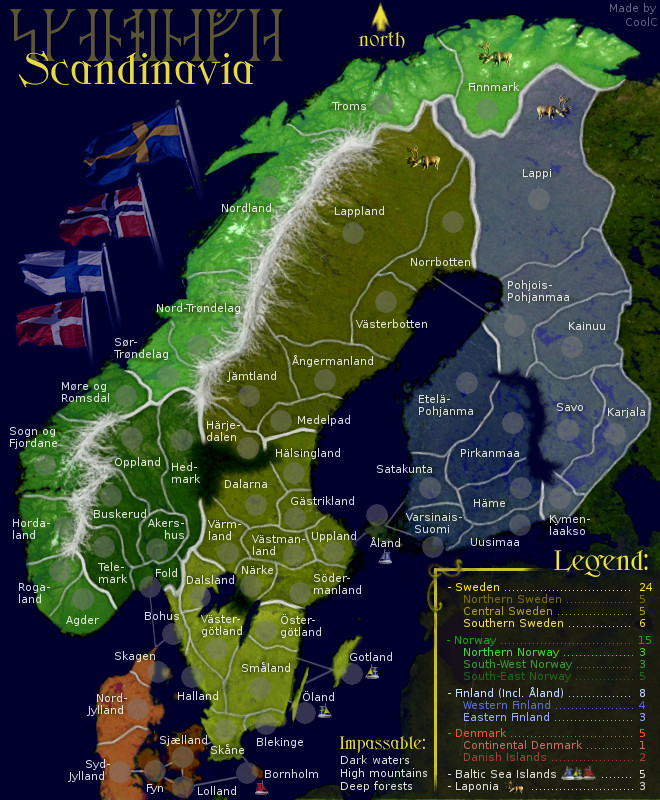
Previous revision changes:
- Reverted back to legend instead of mini-map
- Changed coloring of Åland again, making it more similar to Finland
- Minor change to contrast
Previous Revision 20
LARGE map
SMALL map
Even older versions:
Revision 19 - Large
Revision 19 - Small
Revision 18 - Large
Revision 18 - Small
Revision 17 - Large
Revision 17 - Small
Revision 16 - Large
Revision 16 - Small
Revision 15 - Large
Revision 15 - Small
Revision 14 - Large
Revision 14 - Small
Revision 13 - Large
Revision 13 - Small
Revision 12 - Large
Revision 12 - Small
Revision 11 - Large
Revision 11 - Small
Revision 10 - Large
Revision 10 - Small
Revision 9 - Large
Revision 9 - Small
Revision 8 - Large
Revision 8 - Small
Revision 7 - Large w. brighter light
Revision 7 - Small w. brighter light
Revision 7 - Large w. traditional light
Revision 7 - Small w. traditional light
Revision 6 - Large
Revision 6 - Small
Revision 5 - Large
Revision 5 - Small
Revision 4 - Without Iceland
Revision 4 - With Iceland
Revision 3 - Large
Revision 3 - Small
Revision 2 - Large
Revision 1 - Large
Original version - Large
Original version - Small
Possible later winter version
Extras:
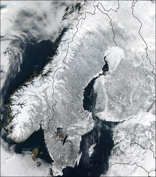
- The images used as a base are public domain satellite photos.
- The runes spell the same word as the latin letters.
- The areas used are real existing ones with only a few exceptions: I have mashed together some east/west, south/north "double areas" like for example West Fold and East Fold. I have removed Oslo area because of space limitations. I also added Skagen as an area to raise the number in Denmark a bit. The areas used for Norway are in use today as secondary communes also known as "Fylken" while the areas selected for Sweden and Finland are the historic "Landskap" because that's what most swedes associate themselves with, rather then the new areas called "Län". In Finland the Landskap still have some official use. For Denmark I had to use just the main islands, again because of space limitations.
Hello everyone, I have created a map over the Nordics, what most people outside the region call Scandinavia (scandinavia is really just the mountain range). It was originally intended to be a pretty small map but instead went the opposite way since I wanted to include real regions and not made up fake ones. If you are wondering why Iceland is not included please see the discussion in the thread. I plan to finish this map myself (both graphics and XML) unless someone offer help.
Description:
Currently we have 4 main "continents" which is the Scandinavian countries:
- Sweden, with 3 subcontinents of 10, 8 and 7 countries (25 total)
- Norway, with 3 subcontinents of 6, 5 and 5 countries (16 total)
- Finland, with 2 subcontinents of 6 countries each, plus neutral Åland (13 total)
- Denmark, with 2 subcontinents of 4 and 3 countries (7 total)
- Grand Total: 61 countries, 10 subcontinents, 4 continents
Two countries are designated to always start neutral: Åland + Bornholm
Bonuses are per subcontinent and continent. The continent bonus is including the subcontinent ones so it's -not- the continent + subcontinent.... in other words it's working exactly the same as in World 2.1. There is also two competitive bonuses which include countries from several different continents (Baltic Sea Islands and Laponia).
Impassables are dark water (ocean and the large lakes in Sweden and Finland), high mountains (in South Norway and the northern border between Norway and Sweden) and deep forests (in Sweden only).
There are no special features besides mentioned neutrals, bonus areas and impassables.
Time plan:
This map was on hold for a very long time for different reasons. Now it's back in active development for the last spurt and my goal is to see it forged as soon as possible.
Future plans:
- Final visual improvements
- XML
Latest revision changes:
- Added compass rose instead of north-arrow
- redone/fixed some sea borders + minor stuff
- swapped norway/sweden in legend
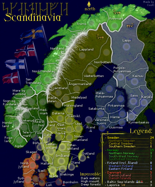
Latest Revision 21
LARGE map
- Click image to enlarge.
SMALL map
- Click image to enlarge.

Previous revision changes:
- Reverted back to legend instead of mini-map
- Changed coloring of Åland again, making it more similar to Finland
- Minor change to contrast
Previous Revision 20
LARGE map
- Click image to enlarge.
SMALL map
- Click image to enlarge.

Even older versions:
Revision 19 - Large
Revision 19 - Small
Revision 18 - Large
Revision 18 - Small
Revision 17 - Large
Revision 17 - Small
Revision 16 - Large
Revision 16 - Small
Revision 15 - Large
Revision 15 - Small
Revision 14 - Large
Revision 14 - Small
Revision 13 - Large
Revision 13 - Small
Revision 12 - Large
Revision 12 - Small
Revision 11 - Large
Revision 11 - Small
Revision 10 - Large
Revision 10 - Small
Revision 9 - Large
Revision 9 - Small
Revision 8 - Large
Revision 8 - Small
Revision 7 - Large w. brighter light
Revision 7 - Small w. brighter light
Revision 7 - Large w. traditional light
Revision 7 - Small w. traditional light
Revision 6 - Large
Revision 6 - Small
Revision 5 - Large
Revision 5 - Small
Revision 4 - Without Iceland
Revision 4 - With Iceland
Revision 3 - Large
Revision 3 - Small
Revision 2 - Large
Revision 1 - Large
Original version - Large
Original version - Small
Possible later winter version
Extras:
- The images used as a base are public domain satellite photos.
- The runes spell the same word as the latin letters.
- The areas used are real existing ones with only a few exceptions: I have mashed together some east/west, south/north "double areas" like for example West Fold and East Fold. I have removed Oslo area because of space limitations. I also added Skagen as an area to raise the number in Denmark a bit. The areas used for Norway are in use today as secondary communes also known as "Fylken" while the areas selected for Sweden and Finland are the historic "Landskap" because that's what most swedes associate themselves with, rather then the new areas called "Län". In Finland the Landskap still have some official use. For Denmark I had to use just the main islands, again because of space limitations.
