Page 2 of 9
Re: Northwest Passage [May 5]

Posted:
Thu May 06, 2010 1:31 amby shakeycat
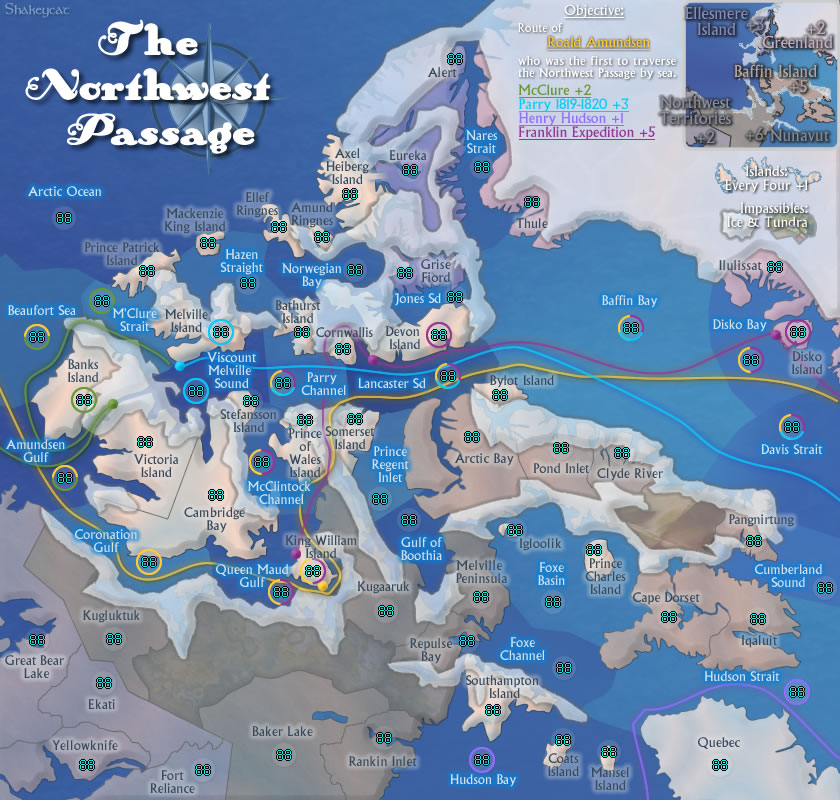
- Click image to enlarge.

I'm not a fan of the text over the minimap, but overall I feel that area is clearer. Need to find subtle way to make yellow Parry bonus not disappear into Greenland's ice.
Stopped mixing fonts so much. The other was cool, but this is clear.
Re: Northwest Passage [May 5]
Posted:
Thu May 06, 2010 1:37 amby natty dread
Orange on blue is not a good combination. They are opposite colours, which creates a really bright contrast, which also does not translate well into JPG (looks very fuzzy).
I suggest changing the colour of the franklin expedition.
Re: Northwest Passage [May 5]
Posted:
Thu May 06, 2010 8:43 amby Industrial Helix
I wonder if bringing back the clearer ice might be better because I'm having trouble identifying islands as two islands seem to me to be connected under the ice.
And personally, I still have a hard time reading this map. I think its connecting the numbers with the territories and the names. Perhaps reduce the opacity on the army circles or get rid of them all together.
Perhaps stretching the map a bit at the expense of the lower left corner would alleviate some congestion in the center. It's already pretty cramped in the middle as it is... do you know for sure that the small map is going to work?
Re: Northwest Passage [May 5]
Posted:
Thu May 06, 2010 8:34 pmby Industrial Helix
Either way, these are graphics and gameplay nitpicks better resolved in the proper forums. Onward and upward!
Re: Northwest Passage [May 7]
Posted:
Fri May 07, 2010 7:48 pmby shakeycat
Thanks for the bump up to Gameplay!

natty_dread wrote:Orange on blue is not a good combination. They are opposite colours, which creates a really bright contrast, which also does not translate well into JPG (looks very fuzzy).
Done: and decided to make the objective route the yellow one.
Industrial Helix wrote:I wonder if bringing back the clearer ice might be better because I'm having trouble identifying islands as two islands seem to me to be connected under the ice.
Let's try 75%, does this work?
Industrial Helix wrote:And personally, I still have a hard time reading this map. I think its connecting the numbers with the territories and the names. Perhaps reduce the opacity on the army circles or get rid of them all together.
Dropped to a mere 10%, better? Nix them?
Industrial Helix wrote:Perhaps stretching the map a bit at the expense of the lower left corner would alleviate some congestion in the center. It's already pretty cramped in the middle as it is... do you know for sure that the small map is going to work?
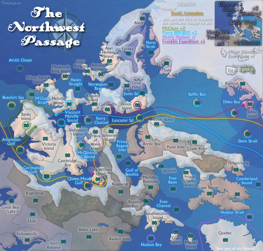
Shrunk left (NWT/ Nunavut), shrunk Victoria island and Baffin, enlarged some smaller islands (Igloolik), messed with some routes (will smooth later). Coronation, Parry, and Lancaster have improved, but not all areas look better. Messy around King William Island. And the water feels patchy again.
And no, I don't think the small map will work as it is right now. I just need to sit down and make it look really smart.
I seem to have forgot this the first time through:
- Click image to enlarge.
Re: Northwest Passage [May 7]
Posted:
Fri May 07, 2010 7:53 pmby army of nobunaga
im a hard sell... trust me... people call me "jerk" and "asshole" a lot here.
this is a winner.
please see it through.
Re: Northwest Passage [May 7]
Posted:
Fri May 07, 2010 10:59 pmby MarshalNey
This last version seems much clearer. The middle area doesn't look cramped to me. Also, by reducing the map circle opacity, the expedition circles stand out much more too. Very nice

I wouldn't reduce the ice opacity any further; the map will end up with confusion over impassibles all over again. I think it's okay as it stands at 75%, where one can just barely see the land underneath.
The tundra might stand to have a bit more texture or color added to distguish itself as impassible, but I might be alone on this thought.
Finally, I think the legend should make the color coding for the various bonus regions clear- it's quite clear on the map itself, but not so much in the legend (the text coloring is pretty slight). This is especially important for the islands- it's very important to know that they are the light pink-ish lands. The legend has an example of the islands, but I just have a feeling people won't pay attention to the color (which is a key to reading the map) unless it's spelled out.
And the two-territory island thing might not work; there's no way to know that from the info on the map.
I have to say I really love the hues and overall look, as well as the gameplay... kinda like Route 66 with open deployment (well, starting positions anyway). I'd keep the victory objective non-neutral if possible.
Excellent work!

Re: Northwest Passage [May 7]
Posted:
Fri May 07, 2010 11:04 pmby MarshalNey
army of nobunaga wrote:im a hard sell... trust me... people call me "jerk" and "asshole" a lot here.
Vocal and demanding perhaps, but 'jerk'? I don't think you can hold a candle to a few I've read, you're way too constructive in your criticism. Have you ever seen mibi's posts?
Re: Northwest Passage [May 7]
Posted:
Sun May 16, 2010 2:08 amby MarshalNey
Oof, did I kill this thread? Seriously, everything I said in the last couple of posts were nitpicks, this really is a good map gameplay-wise... do the cartographers out there agree?
Re: Northwest Passage [May 7]
Posted:
Sun May 16, 2010 11:08 pmby shakeycat
Marshal, Nobunaga, thanks for your responses. I've just been taking my time on this one.
I don't like the legend as it is. The ice makes it a bit funny in some places. Maybe with a larger version I can tie in the islands or something. I'll play with it.
I'm also going to mark Quebec as not having a bonus, so it is not assumed to be an island. The colour may not be enough?
The tundra is going to be better in the next version too, more even.
Do I really have to say what is and isn't an island? How do I say this, "Islands are peach-coloured pieces of land, and do not include Ellesmere or Baffin and especially not Quebec" ?
And is there anything at all troubling about the gameplay? I drew in the impassibles based on where ice naturally is, and which territories had too many borders (ie. Baffin Bay), so it may not be well thought-out in all areas. Are there any crazy bottlenecks? Territories with too much power? Any issues moving left/right or top/bottom, diagonally?
Re: Northwest Passage [May 7]
Posted:
Mon May 17, 2010 11:41 amby AndyDufresne
There may be some initial confusion in regards to which areas can assault where---maybe push the water differentiation a little further. And no doubt people will wonder how Islands assault (I.E. "Does one Island assault through water to the other like in Land & Sea?" or "Can Islands assault each other in the same body of water?") No doubt those will be the types of initial questions I think.
--Andy
Re: Northwest Passage [May 7]
Posted:
Thu May 20, 2010 10:20 amby Evil DIMwit
1.
shakeycat wrote:Do I really have to say what is and isn't an island? How do I say this, "Islands are peach-coloured pieces of land, and do not include Ellesmere or Baffin and especially not Quebec" ?
I suggest you at least rename that bonus "minor islands" just to be clear.
2. Could you describe the starting position configuration you have in mind?
3. Also, a couple of clarification points:
Is there a connection between Clyde River and Pangnirtung? Or is that an impassable smudge in the middle?
Does Ilulissat border Disko Bay?
It's also a little difficult to see if Somerset Island borders Lancaster Sd, due to the army circle and the poor JPEG quality.
Overall, I really like the passagewayishness of this map and how it captures the spirit of the Northwest Passage endeavor. Good work!
Re: Northwest Passage [May 25]
Posted:
Tue May 25, 2010 3:29 pmby shakeycat
Hopefully Clyde River/Pangnirtung are clearer now with their non-connection.
Do you mean Illusiat and Davis Strait? Because I would think the Disko Bay connection is obvious. I moved the Davis connection to make it a little easier to notice, as well as connecting the pink and fibbing on the land a bit. Does it help?
- Click image to enlarge.
Shifted the ice between Somerset and Lancaster: is it better? Still difficult?
Starting Positions. Good question.
- Click image to enlarge.
Quebec and Gulf of Boothia are the dummy territories for red and blue, to make up for the extra territory yellow gets. If there is a better territory than Boothia, please point it out. I wanted something that was not part of any bonus, and didn't border any islands.
I tried to split evenly territories that bordered the same water (Arctic, Hudson). The number of borders on territories are not as even as I would like, since red gets more with only 1 border.
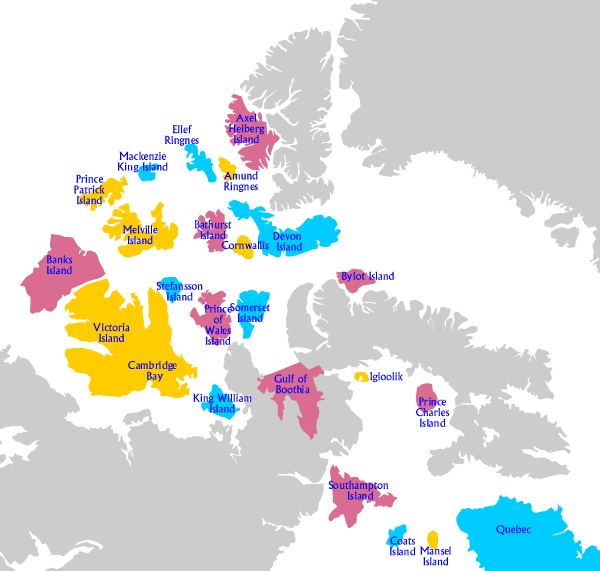
RED:
Southampton 1
Axel Heiberg 2
Bathurst 3
Bylot 1
Prince of Wales 1
Banks 2
Prince Charles 1
(Gulf of Boothia 4)
BLUE:
Coats 1
Ellef Ringnes 3
Mackenzie King 2
Devon 2
Somerset 2
King William 1
Stefansson 2
(Quebec 2)
YELLOW:
Mansel 1
Amund Ringnes 1
Prince Patrick 3
Cornwallis 2
Igloolik 1
Melville 2
[Victoria 2
Cambridge Bay 4]
Re: Northwest Passage [May 25]
Posted:
Tue May 25, 2010 10:43 pmby Evil DIMwit
shakeycat wrote:Hopefully Clyde River/Pangnirtung are clearer now with their non-connection.
Yep.
Do you mean Illusiat and Davis Strait? Because I would think the Disko Bay connection is obvious.
Yep, that's the one. Looks good.
Shifted the ice between Somerset and Lancaster: is it better? Still difficult?
Better.
As for the starting positions...
Hmm...
Hmmmm.....
Yeah, I don't know if you can do much better. It might be a bit awkward for 4 players since there's still a 20-or-so percent chance that someone will start with +2 from islands and someone will start with +0. But then dividing the islands into four starting positions would bring its own problems for 3p games, and I guess 3p games give less opportunity for the inequity to be corrected by diplomacy.
Re: Northwest Passage [May 25]
Posted:
Thu Jun 03, 2010 1:37 pmby shakeycat
Evil DIMwit, thank you for your response. I didn't consider 4 player games, but I think you're right that it would not be too much of an issue. Even if the person goes first, with a +2 bonus, three other people each with a decent starting bonus - 5 armies each (~17 territs) - would be able to even things out. It also takes a significant blow to pull the starting bonus down.
Maybe in 4 player doubles it could be a little harder if one team starts off so well. And there's a chance in Freestyle that the game could be cinched in round 1 like this, if one team is so lucky. I haven't followed the Pearl Harbour thread, but I'm sure they had similar issues.
Are we okay with the following bonuses being a random drop?:
Ellesmere Island (3 regions, unattached)
Greenland (3 regions, unattached)
Hudson (2 regions, with one holding 3 internal islands)
I figure Ellesmere and Greenland are okay, since none of the territories touch, and would be hard to hold. By that measure, they should both have the same bonus: either +2 or +3. Which is more appropriate?
Hudson's route concerns me because if I give Hudson Bay to one person, he can quickly sweep out the other two islands which are waterlocked. Should Hudson Bay start neutral, considering this and the bonus it is a part of? Consider also that Hudson Bay is a critical access point for southern Nunavut and NWT.
Re: Northwest Passage [May 25]
Posted:
Sun Jun 06, 2010 4:23 pmby Evil DIMwit
Isn't McClure 4 regions, counting Banks Island?
Re: Northwest Passage [May 25]
Posted:
Sun Jun 06, 2010 9:54 pmby shakeycat
Evil DIMwit wrote:Isn't McClure 4 regions, counting Banks Island?
You're right! Forget I ever mentioned it :}
And here I was going to respond with "this is why I outlined the army circles, so we wouldn't have people assuming that just because the line came close that it included that territory... " I understand now that the map absolutely would not function without them!
Re: Northwest Passage [May 25]
Posted:
Sun Jun 06, 2010 10:34 pmby Evil DIMwit
Hah! Okay, well, I think that Hudson is all right for the drop, since it's only a 1 troop bonus, it's surrounded by a lot of territories, and this is a big map. As for Greenland and Ellesmere, even a +2 bonus from either could make more of a dent in the game balance; my suggestion is that you pick a territory from each one to start with a 2-count neutral. You can afford to bring the deployable territory count to 66 and still be at a Safe Number. I also think it's appropriate for Ellesmere to be worth more than Greenland since the former's territories are topologically so far apart and so out of the way, while the latter's are close together.
Re: Northwest Passage [May 25]
Posted:
Fri Jun 18, 2010 4:36 pmby shakeycat
So in that case: Ellesmere bonus is +3, Greenland +2, nothing changes there.
Ilulissat and Alert will drop with 2 neutrals each. Easy to kill, but nobody starts with a bonus from them. I like that. Would any of the other territories be better for the 2 neutrals?
Re: Northwest Passage [May 25]
Posted:
Thu Jun 24, 2010 2:58 amby iancanton
not only does the minor islands bonus cause some difficulties during the drop (some players will have a bonus and others won't), but it also draws the focus away from the explorer routes to the point where only hudson and mcclure are realistic targets. try removing the minor islands bonus and replacing it with a +1 build-ur-own bonus for every explorer troop circle held (separate from the existing explorer route bonuses) - the 19 explorer regions obviously have to start neutral, perhaps with 2 troops. conceptually, this represents the fact of there initially being no northwest passage and one having to be discovered by breaking the ice. this will surely bring back the focus to where it ought to be.
ian.
Re: Northwest Passage [May 25]
Posted:
Sat Jun 26, 2010 2:13 amby shakeycat
Ian,
Good idea. I like it. There really was no reason to make islands important.
I suppose bisecting the map with a line of neutrals isn't a problem, since Route 66 does it. Build-a-bonus would be +1 for how many?, and need they be touching or no?
2 or 3 neutral start, I'm not sure which is better. If it's breaking-the-ice, 2 would imply that it is easy. yet it doesn't make the passage a barrier either. And if there's a build-a-bonus to be had, a 3 neutral start sounds more reasonable. If it's "ice breaking", should some be easier and some harder? Though the picture no longer shows it, Coronation Gulf is much harder than something like Davis Strait. I think Queen Maud is very shallow in some places too. Of course, if it ISN'T either all 2 or all 3, then it would have to be somewhat logical and improve the gameplay in some way.
Should land that is part of the route (Banks, Disko, Devon, King William, Melville) have a +1 autodeploy? Reason being, they are places where the ship harbours and recharges. Just an idea, maybe too much complication if we add that.
I wonder, would players go straight for the routes or would they try to take advantage of either the top or the bottom? I'm sure there's too many total territories to make it easy to kick someone out of the top or bottom.
Re: Northwest Passage [May 25]
Posted:
Sun Jun 27, 2010 5:16 amby iancanton
shakeycat wrote:I suppose bisecting the map with a line of neutrals isn't a problem, since Route 66 does it.
the idea came from route 66!
shakeycat wrote:Build-a-bonus would be +1 for how many?, and need they be touching or no?
my initial thought was +1 for each 1, though we could specify that only chains of 2 or more adjacent circles will count.
ian.
Re: Northwest Passage [May 25]
Posted:
Wed Jul 21, 2010 5:37 pmby MrBenn
[
Moved]
It would appear that development of this map has stalled. If the mapmaker wants to continue with the map, then one of the Foundry Moderators will be able to help put the thread back into the Foundry system,
after an update has been made.
Re: Northwest Passage [May 25]
Posted:
Thu Jul 22, 2010 7:34 amby ender516
MrBenn wrote:[
Moved]
It would appear that development of this map has stalled. If the mapmaker wants to continue with the map, then one of the Foundry Moderators will be able to help put the thread back into the Foundry system,
after an update has been made.
Oh, this is a shame. I have been looking forward to this map. I hope it is resurrected.
Re: Northwest Passage [May 25]
Posted:
Thu Jul 22, 2010 7:12 pmby MarshalNey

I feel that somehow I've let this map down. The first draft of this map was so very good, and it looked so elegant that I thought it was a clinch for the Final Forge.