It's better than nothing and it helps balance out the map imo.
What kind of file is this... I want to make more accurate regions but I really don't want to type them out. It might be better, if you were willing, to just send me the file, make the name changes and send it back.
Dark Continent (Colonial Africa) [Quenched]
Moderator: Cartographers
Re: Colonial Africa 1.1
![]() by Industrial Helix on Sun Jan 30, 2011 10:45 pm
by Industrial Helix on Sun Jan 30, 2011 10:45 pm
Sketchblog [Update 07/25/11]: http://indyhelixsketch.blogspot.com/
Living in Japan [Update 07/17/11]: http://mirrorcountryih.blogspot.com/
Russian Revolution map for ConquerClub [07/20/11]: viewtopic.php?f=241&t=116575
Living in Japan [Update 07/17/11]: http://mirrorcountryih.blogspot.com/
Russian Revolution map for ConquerClub [07/20/11]: viewtopic.php?f=241&t=116575
-

 Industrial Helix
- Posts: 3462
- Joined: Mon Jul 14, 2008 6:49 pm
- Location: Ohio


Re: Colonial Africa 1.1
![]() by The Bison King on Sun Jan 30, 2011 11:12 pm
by The Bison King on Sun Jan 30, 2011 11:12 pm
Industrial Helix wrote:It's better than nothing and it helps balance out the map imo.
What kind of file is this... I want to make more accurate regions but I really don't want to type them out. It might be better, if you were willing, to just send me the file, make the name changes and send it back.
what I post are Jpg's if you Pm me your email I could send you the PSD.

-

The Bison King
- Posts: 1957
- Joined: Thu Aug 27, 2009 5:06 pm
- Location: the Mid-Westeros


Re: Colonial Africa 1.2
![]() by The Bison King on Fri Feb 11, 2011 1:01 pm
by The Bison King on Fri Feb 11, 2011 1:01 pm
- Click image to enlarge.

Ok I've made some changes to how the Navies work. Not only can they be attacked by Any Colonial power OR SOUTH AFRICA they can attack any colonial power OR SOUTH AFRICA back. The can still 1 way assualt territories along the African coast as well. I think this will give the map a much greater mobility. Now, you can move from the far south to any European territory with in a couple moves. I think this will go a long way in keeping Europe from being monopolized by a single player since now you would have to defend every single Colonial power instead of just Germany Italy and France.
I made it so that single territory west African territories like Gold, and Ivory coast only reap a +1 bonus with the European power. With out that they aren't worth anything.
I'm also considering making all European powers +1 auto deploys. This would help it so that players don't have to waste all their troops defending their European claims.
-
The Bison King
- Posts: 1957
- Joined: Thu Aug 27, 2009 5:06 pm
- Location: the Mid-Westeros
Re: Colonial Africa 1.2
![]() by The Bison King on Sat Feb 12, 2011 9:57 am
by The Bison King on Sat Feb 12, 2011 9:57 am
To whom ever is in charge of advancing this map:
Could I please see some activity here? This was stickied and now it's not. I've made all the changes that IH had requested, and all those changes have been gameplay concerns any way. I really feel like this should be in gameplay at this point.
Thank you
Could I please see some activity here? This was stickied and now it's not. I've made all the changes that IH had requested, and all those changes have been gameplay concerns any way. I really feel like this should be in gameplay at this point.
Thank you
-
The Bison King
- Posts: 1957
- Joined: Thu Aug 27, 2009 5:06 pm
- Location: the Mid-Westeros
Re: Colonial Africa 1.2
![]() by natty dread on Sat Feb 12, 2011 10:04 am
by natty dread on Sat Feb 12, 2011 10:04 am
The unstickyness is probably due to the restructuring of foundry - as you can see, there are no more stickies in the drafting room, at all...

-

natty dread
- Posts: 12877
- Joined: Fri Feb 08, 2008 8:58 pm
- Location: just plain fucked


Re: Colonial Africa 1.2
![]() by Victor Sullivan on Sat Feb 12, 2011 10:07 am
by Victor Sullivan on Sat Feb 12, 2011 10:07 am
Let's get this thing redded, I say it's been done concept-wise for a while.
Beckytheblondie: "Don't give us the dispatch, give us a mustache ride."
Scaling back on my CC involvement...
Scaling back on my CC involvement...
-

Victor Sullivan
- Posts: 6010
- Joined: Mon Feb 08, 2010 8:17 pm
- Location: Columbus, OH


Re: Colonial Africa 1.2
![]() by The Bison King on Wed Mar 02, 2011 12:50 pm
by The Bison King on Wed Mar 02, 2011 12:50 pm
- Click image to enlarge.

I'm throwing out a little preview of the new graphics I'm working on, to help regain interest.
-
The Bison King
- Posts: 1957
- Joined: Thu Aug 27, 2009 5:06 pm
- Location: the Mid-Westeros
Re: Colonial Africa 1.2
![]() by natty dread on Wed Mar 02, 2011 12:55 pm
by natty dread on Wed Mar 02, 2011 12:55 pm
Nice! Do I see influence from RjBeals' style there?
-
natty dread
- Posts: 12877
- Joined: Fri Feb 08, 2008 8:58 pm
- Location: just plain fucked
Re: Colonial Africa 1.2
![]() by Victor Sullivan on Wed Mar 02, 2011 11:45 pm
by Victor Sullivan on Wed Mar 02, 2011 11:45 pm
That's gorgeous, TBK! I look forward to discussing gameplay in the Gameplay Workshop 
Beckytheblondie: "Don't give us the dispatch, give us a mustache ride."
Scaling back on my CC involvement...
Scaling back on my CC involvement...
-
Victor Sullivan
- Posts: 6010
- Joined: Mon Feb 08, 2010 8:17 pm
- Location: Columbus, OH
Re: Colonial Africa 1.2
![]() by natty dread on Thu Mar 03, 2011 2:10 am
by natty dread on Thu Mar 03, 2011 2:10 am
One thing is the dashed stripes... they look pasted on, since the shading lines don't go over the dashes like they do on the other colours...
-
natty dread
- Posts: 12877
- Joined: Fri Feb 08, 2008 8:58 pm
- Location: just plain fucked
Re: Colonial Africa 1.2
![]() by Victor Sullivan on Thu Mar 03, 2011 9:10 pm
by Victor Sullivan on Thu Mar 03, 2011 9:10 pm
natty_dread wrote:One thing is the dashed stripes... they look pasted on, since the shading lines don't go over the dashes like they do on the other colours...
True, but one step at a time
Beckytheblondie: "Don't give us the dispatch, give us a mustache ride."
Scaling back on my CC involvement...
Scaling back on my CC involvement...
-
Victor Sullivan
- Posts: 6010
- Joined: Mon Feb 08, 2010 8:17 pm
- Location: Columbus, OH
Re: Colonial Africa 1.2
![]() by thenobodies80 on Sat Mar 05, 2011 6:53 pm
by thenobodies80 on Sat Mar 05, 2011 6:53 pm
Considering the technique you're going to use on this map and the effort/time you're going to put onto it, I have to warn you about the color you're going to use.
See how it looks for colorblind people:
Let me say that if it was my map I would focus more on the African continent without the Ottoman and Russian part, but probably it's just a personal preference.
Could you please update your first post so everyone can have a clear idea of your current gameplay? (I ask because the artistic version shows some difference from the computer image in the OP)
Thanks in advance
Nobodies
-

thenobodies80
- Posts: 5400
- Joined: Wed Sep 05, 2007 4:30 am
- Location: Milan


Re: Colonial Africa 1.2
![]() by RjBeals on Sat Mar 05, 2011 7:32 pm
by RjBeals on Sat Mar 05, 2011 7:32 pm
natty_dread wrote:Nice! Do I see influence from RjBeals' style there?
hah.. i think it looks nice so far.

-

RjBeals
- Posts: 2506
- Joined: Mon Nov 20, 2006 5:17 pm
- Location: South Carolina, USA


Re: Colonial Africa 1.2
![]() by The Bison King on Mon Mar 07, 2011 5:55 pm
by The Bison King on Mon Mar 07, 2011 5:55 pm
One thing is the dashed stripes... they look pasted on, since the shading lines don't go over the dashes like they do on the other colours...
Working on it.
Could you please update your first post so everyone can have a clear idea of your current gameplay? (I ask because the artistic version shows some difference from the computer image in the OP)
Working on it. I'll have a full new version up soon.
Considering the technique you're going to use on this map and the effort/time you're going to put onto it, I have to warn you about the color you're going to use.
See how it looks for colorblind people:
I can always mess with the color's later. BTW this has all been on the computer so far, I haven't touched paint or paper. Even if I had though modifying color's is still very easy to do on a traditionally colored map, in the computer.
-
The Bison King
- Posts: 1957
- Joined: Thu Aug 27, 2009 5:06 pm
- Location: the Mid-Westeros
Re: Colonial Africa 1.3
![]() by The Bison King on Tue Mar 08, 2011 12:32 am
by The Bison King on Tue Mar 08, 2011 12:32 am
- Click image to enlarge.

- Click image to enlarge.

Here's the new version. How are we liking this. I think I made the legend a lot more concise by adding the bonus add on's onto the mini map.
-
The Bison King
- Posts: 1957
- Joined: Thu Aug 27, 2009 5:06 pm
- Location: the Mid-Westeros

Re: Colonial Africa 1.3
![]() by The Bison King on Wed Mar 09, 2011 3:48 pm
by The Bison King on Wed Mar 09, 2011 3:48 pm
Yay!
First things to be worked on:
Territory names
adding Impassable's
Bonus Values
First things to be worked on:
Territory names
adding Impassable's
Bonus Values
-
The Bison King
- Posts: 1957
- Joined: Thu Aug 27, 2009 5:06 pm
- Location: the Mid-Westeros
Re: Colonial Africa 1.3
![]() by Industrial Helix on Wed Mar 09, 2011 10:45 pm
by Industrial Helix on Wed Mar 09, 2011 10:45 pm
I've got a good knowledge of African geography... if you like, send me the psd file and I'll swap the names out for you. I think it would be too much to just list them all.
Sketchblog [Update 07/25/11]: http://indyhelixsketch.blogspot.com/
Living in Japan [Update 07/17/11]: http://mirrorcountryih.blogspot.com/
Russian Revolution map for ConquerClub [07/20/11]: viewtopic.php?f=241&t=116575
Living in Japan [Update 07/17/11]: http://mirrorcountryih.blogspot.com/
Russian Revolution map for ConquerClub [07/20/11]: viewtopic.php?f=241&t=116575
-
Industrial Helix
- Posts: 3462
- Joined: Mon Jul 14, 2008 6:49 pm
- Location: Ohio
Re: Colonial Africa 1.3
![]() by The Bison King on Thu Mar 10, 2011 12:40 am
by The Bison King on Thu Mar 10, 2011 12:40 am
Industrial Helix wrote:I've got a good knowledge of African geography... if you like, send me the psd file and I'll swap the names out for you. I think it would be too much to just list them all.
Sounds good to me, go ahead and PM me your email address and I can pass that along to you.
-
The Bison King
- Posts: 1957
- Joined: Thu Aug 27, 2009 5:06 pm
- Location: the Mid-Westeros
Re: Colonial Africa 1.3
![]() by The Bison King on Mon Mar 14, 2011 11:01 pm
by The Bison King on Mon Mar 14, 2011 11:01 pm
- Click image to enlarge.

- Click image to enlarge.

Ok here's where I'm at at this moment. I'm currently waiting on IH to send me a version with revised territory names. In the mean time I made a few small changes here that can be easily dropped into the IH's new Version. I added a big Impassable Sand Dune over present day Camaroon and Nigeria, and I've also made all European Colonial power territories +1 auto deploys. I did this because I don't want players to waste all their troops defending their European territories rather than dukeing it out in Africa. I figure if it's a +1 auto deploy most of the work is done for them.
-
The Bison King
- Posts: 1957
- Joined: Thu Aug 27, 2009 5:06 pm
- Location: the Mid-Westeros
Re: Colonial Africa 1.4
![]() by natty dread on Tue Mar 15, 2011 3:18 am
by natty dread on Tue Mar 15, 2011 3:18 am
You must be in love with this font... 
-
natty dread
- Posts: 12877
- Joined: Fri Feb 08, 2008 8:58 pm
- Location: just plain fucked
Re: Colonial Africa 1.4
![]() by The Bison King on Wed Mar 16, 2011 5:26 pm
by The Bison King on Wed Mar 16, 2011 5:26 pm
natty_dread wrote:You must be in love with this font...
Yeah I do, but I'll probably end up changing it at some point.
Here's the version IH revised:
- Click image to enlarge.

-
The Bison King
- Posts: 1957
- Joined: Thu Aug 27, 2009 5:06 pm
- Location: the Mid-Westeros
Re: Colonial Africa 1.4
![]() by Industrial Helix on Thu Mar 17, 2011 8:17 am
by Industrial Helix on Thu Mar 17, 2011 8:17 am
Hmm yeah... hope you don't mind my hack job over in the Ottoman Empire.
Sketchblog [Update 07/25/11]: http://indyhelixsketch.blogspot.com/
Living in Japan [Update 07/17/11]: http://mirrorcountryih.blogspot.com/
Russian Revolution map for ConquerClub [07/20/11]: viewtopic.php?f=241&t=116575
Living in Japan [Update 07/17/11]: http://mirrorcountryih.blogspot.com/
Russian Revolution map for ConquerClub [07/20/11]: viewtopic.php?f=241&t=116575
-
Industrial Helix
- Posts: 3462
- Joined: Mon Jul 14, 2008 6:49 pm
- Location: Ohio
Re: Colonial Africa 1.4
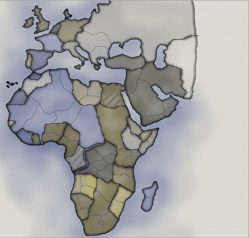
![]() by The Bison King on Fri Mar 18, 2011 12:42 am
by The Bison King on Fri Mar 18, 2011 12:42 am
- Click image to enlarge.

Ok here's my restructure based on IH's Revisions. Arabia is now it's own independant non-bonus region. I also went ahead and made a few more name changes. Also I added another Immpassable in the Ethiopia area. Maybe I'm going mad with immpassable's what do you guys think?
-
The Bison King
- Posts: 1957
- Joined: Thu Aug 27, 2009 5:06 pm
- Location: the Mid-Westeros
Re: Colonial Africa 1.4
![]() by Teflon Kris on Fri Mar 18, 2011 6:16 pm
by Teflon Kris on Fri Mar 18, 2011 6:16 pm
The Bison King wrote:
- Click image to enlarge.
Ok here's my restructure based on IH's Revisions. Arabia is now it's own independant non-bonus region. I also went ahead and made a few more name changes. Also I added another Immpassable in the Ethiopia area. Maybe I'm going mad with immpassable's what do you guys think?
I'm an impassables fan - you could always use the River Niger too .
-

Teflon Kris
- Posts: 4236
- Joined: Sun Jul 13, 2008 4:39 pm
- Location: Lancashire, United Kingdom


Who is online
Users browsing this forum: No registered users
|
|||||||
| Conquer Club is not associated with RISK online in any way. Copyright © 2006-2024 by Big Wham LLC | |||||||