Very nice map -- however, there are some pretty significant mountains along the western, southern, and eastern edges of the "Bakersfield" territory, not unlike the "coastal range" mountains shown farther north. You could put brown mountains between Bakersfield & Santa Barbara, between Bakersfield and 2 of the 3 "L.A." territories, and between Bakersfield and Mojave. One thing that defines the Central (San Joaquin) Valley geographically is that it's bounded by mountains all around -- Coastal Range on the west, Sierra Nevada on the east, and San Gabriels/Tehachapis/etc. around the southern end (Bakersfield/Kern County).
Of course, that would make Central Valley easier to defend, so maybe its bonus could be reduced to 5 (especially since it has FIVE cities!).
Also I would prefer "Imperial" over "Palm Springs"... and could you show a little bit of blue for the California portion of Lake Tahoe in the territory of that name?
(From a former resident of San Diego; living in Bakersfield since 1980).
California [Quenched]
Moderator: Cartographers
Re: California 1.6
![]() by Vlasov on Thu Oct 28, 2010 12:48 pm
by Vlasov on Thu Oct 28, 2010 12:48 pm
-

 Vlasov
- Posts: 234
- Joined: Sun Apr 16, 2006 2:45 pm
- Location: Baker's Field


Re: California 1.6
![]() by The Bison King on Fri Oct 29, 2010 12:22 am
by The Bison King on Fri Oct 29, 2010 12:22 am
Very nice map -- however, there are some pretty significant mountains along the western, southern, and eastern edges of the "Bakersfield" territory, not unlike the "coastal range" mountains shown farther north. You could put brown mountains between Bakersfield & Santa Barbara, between Bakersfield and 2 of the 3 "L.A." territories, and between Bakersfield and Mojave. One thing that defines the Central (San Joaquin) Valley geographically is that it's bounded by mountains all around -- Coastal Range on the west, Sierra Nevada on the east, and San Gabriels/Tehachapis/etc. around the southern end (Bakersfield/Kern County).
I know what you are saying but I have to leave a lot of those territories open to keep things from becoming too easy to hole. Specifically what I'm thinking about is that Central coast bonus. However, I could extend the mountains down just a little to cover all of Sierra Madre, while leaving Morro bay attack-able by Bakersfield. I also might consider adding mountains between Bakersfield and the top of the LA bonus, if L.A. proves to be too hard to hold.
Also I would prefer "Imperial" over "Palm Springs
That does sound good.

-

The Bison King
- Posts: 1957
- Joined: Thu Aug 27, 2009 5:06 pm
- Location: the Mid-Westeros


Re: California 1.6
![]() by Vlasov on Mon Nov 01, 2010 2:34 pm
by Vlasov on Mon Nov 01, 2010 2:34 pm
I think I said: Add two mountain boundaries between Bakersfield and L.A., out of the three you have now. The two actual mountain highway passes are Tejon/I-5 (to San Fernando Valley; AKA the Grapevine) and Cajon/I-15 (80 miles east, into Riverside).
Also, it should be El Dorado, not "Elderado".
Also, it should be El Dorado, not "Elderado".
-
Vlasov
- Posts: 234
- Joined: Sun Apr 16, 2006 2:45 pm
- Location: Baker's Field
Re: California 1.6
![]() by Industrial Helix on Mon Nov 01, 2010 8:44 pm
by Industrial Helix on Mon Nov 01, 2010 8:44 pm
Not digging the photo background but the greens over to the right are a nice balance to the overall color scheme.
Sketchblog [Update 07/25/11]: http://indyhelixsketch.blogspot.com/
Living in Japan [Update 07/17/11]: http://mirrorcountryih.blogspot.com/
Russian Revolution map for ConquerClub [07/20/11]: viewtopic.php?f=241&t=116575
Living in Japan [Update 07/17/11]: http://mirrorcountryih.blogspot.com/
Russian Revolution map for ConquerClub [07/20/11]: viewtopic.php?f=241&t=116575
-

Industrial Helix
- Posts: 3462
- Joined: Mon Jul 14, 2008 6:49 pm
- Location: Ohio


Re: California 1.1
![]() by MrBenn on Wed Nov 03, 2010 1:11 pm
by MrBenn on Wed Nov 03, 2010 1:11 pm
The Bison King wrote:Victor Sullivan wrote:MrBenn wrote:I hate to say it, but I really don;t think the visual style fits the theme of the map at all... while it worked for Thyseneal, I don't know how well it works here.
I agree, but does it matter at this stage? I feel like we still need to figure out some of the gameplay concepts, bonus areas, etc.
-Sulls
We're not in graphics yet. One thing at a time.
Now that we're in graphics, I'm going to bring this back up.
I really don't think the watercolour style works on this map. You could probably get away with it if you were doing something like this (below), but I don't know here
 Part of me thinks a complete graphical overhaul may be in order?

PB: 2661 | He's blue... If he were green he would die | No mod would be stupid enough to do that
-

MrBenn
- Posts: 6880
- Joined: Wed Nov 21, 2007 9:32 am
- Location: Off Duty


Re: California 1.6
![]() by The Bison King on Wed Nov 03, 2010 5:26 pm
by The Bison King on Wed Nov 03, 2010 5:26 pm
- Click image to enlarge.

Well here's a slight update. I've taken out all the things that I wasn't so sure about' like the banner and the background to the legend. I replaced the Cities with stars which I rather like.
MrBenn wrote:The Bison King wrote:Victor Sullivan wrote:MrBenn wrote:I hate to say it, but I really don;t think the visual style fits the theme of the map at all... while it worked for Thyseneal, I don't know how well it works here.
I agree, but does it matter at this stage? I feel like we still need to figure out some of the gameplay concepts, bonus areas, etc.
-Sulls
We're not in graphics yet. One thing at a time.
Now that we're in graphics, I'm going to bring this back up.
I really don't think the watercolour style works on this map. You could probably get away with it if you were doing something like this (below), but I don't know here
I rather like this little map you have posted here. While I agree that the same old water color treatment for the background and legend may not work I think on the map it's self it works fine. But then again I might still be able to pull it off. I think I really need to reel it back, and make it a little easier to look at.
-
The Bison King
- Posts: 1957
- Joined: Thu Aug 27, 2009 5:06 pm
- Location: the Mid-Westeros
Re: California 1.6
![]() by The Bison King on Wed Nov 03, 2010 6:34 pm
by The Bison King on Wed Nov 03, 2010 6:34 pm
- Click image to enlarge.

- Click image to enlarge.

Ok using that little tourist map as reference this is the direction I think I want to go. OBVIOUSLY, some elements are just representational right now and are not final renderings, like the Palm tree, which will be done in a more painterly fashion. I'm also thinking I need to zoom out a tad on everything and give this thing a border or edge.
I posted 2 versions with different versions of the water. What I want to know is which is a better fit? Should I use photographs at all or should I keep them out of here?
-
The Bison King
- Posts: 1957
- Joined: Thu Aug 27, 2009 5:06 pm
- Location: the Mid-Westeros
Re: California 1.6
![]() by Victor Sullivan on Wed Nov 03, 2010 8:40 pm
by Victor Sullivan on Wed Nov 03, 2010 8:40 pm
I like the second one better; it adds more dimension to the map, I think. A border and zoom-out would be good, I think.
Beckytheblondie: "Don't give us the dispatch, give us a mustache ride."
Scaling back on my CC involvement...
Scaling back on my CC involvement...
-

Victor Sullivan
- Posts: 6010
- Joined: Mon Feb 08, 2010 8:17 pm
- Location: Columbus, OH


Re: California 1.9
![]() by The Bison King on Thu Nov 11, 2010 4:05 pm
by The Bison King on Thu Nov 11, 2010 4:05 pm
- Click image to enlarge.

- Click image to enlarge.

-
The Bison King
- Posts: 1957
- Joined: Thu Aug 27, 2009 5:06 pm
- Location: the Mid-Westeros
Re: California 1.9
![]() by Victor Sullivan on Thu Nov 11, 2010 4:17 pm
by Victor Sullivan on Thu Nov 11, 2010 4:17 pm
Certainly an improvement. I hope you'll be fixing your signature though...
Beckytheblondie: "Don't give us the dispatch, give us a mustache ride."
Scaling back on my CC involvement...
Scaling back on my CC involvement...
-
Victor Sullivan
- Posts: 6010
- Joined: Mon Feb 08, 2010 8:17 pm
- Location: Columbus, OH
Re: California 1.9
![]() by The Bison King on Thu Nov 11, 2010 4:30 pm
by The Bison King on Thu Nov 11, 2010 4:30 pm
Victor Sullivan wrote:Certainly an improvement. I hope you'll be fixing your signature though...
Yeah I will.
-
The Bison King
- Posts: 1957
- Joined: Thu Aug 27, 2009 5:06 pm
- Location: the Mid-Westeros
Re: California 1.9
![]() by The Bison King on Thu Nov 11, 2010 4:31 pm
by The Bison King on Thu Nov 11, 2010 4:31 pm
The Bison King wrote:
- Click image to enlarge.
- Click image to enlarge.
Bumping, from last page
-
The Bison King
- Posts: 1957
- Joined: Thu Aug 27, 2009 5:06 pm
- Location: the Mid-Westeros
Re: California 2.0
![]() by The Bison King on Tue Nov 16, 2010 3:05 pm
by The Bison King on Tue Nov 16, 2010 3:05 pm
- Click image to enlarge.

- Click image to enlarge.

Ok with this upload you can pretty much see how it's going to be. All the temporary images have been removed and we can start ironing out all the little nitpicks.
-
The Bison King
- Posts: 1957
- Joined: Thu Aug 27, 2009 5:06 pm
- Location: the Mid-Westeros
Re: California 2.0
![]() by Bruceswar on Tue Nov 16, 2010 3:26 pm
by Bruceswar on Tue Nov 16, 2010 3:26 pm
I like where this is going, but also I am not liking the floating land mass idea. Connect it into the US somehow.
Highest Rank: 26 Highest Score: 3480

-

Bruceswar
- Posts: 9713
- Joined: Sun Dec 23, 2007 12:36 am
- Location: Cow Pastures


Re: California 2.0
![]() by Victor Sullivan on Tue Nov 16, 2010 4:37 pm
by Victor Sullivan on Tue Nov 16, 2010 4:37 pm
Ack! Yosemite needs to be capitalized!!
Beckytheblondie: "Don't give us the dispatch, give us a mustache ride."
Scaling back on my CC involvement...
Scaling back on my CC involvement...
-
Victor Sullivan
- Posts: 6010
- Joined: Mon Feb 08, 2010 8:17 pm
- Location: Columbus, OH
Re: California 2.0
![]() by The Bison King on Tue Nov 16, 2010 5:25 pm
by The Bison King on Tue Nov 16, 2010 5:25 pm
Bruceswar wrote:I like where this is going, but also I am not liking the floating land mass idea. Connect it into the US somehow.
I had it that way earlier and visually it really didn't do it for me. Also I think it works as disconnected conceptually as well. This is about California as it's own place, not a small part of a larger whole.
Victor Sullivan wrote:Ack! Yosemite needs to be capitalized!!
uh... yeah I think you're right. Good catch.
-
The Bison King
- Posts: 1957
- Joined: Thu Aug 27, 2009 5:06 pm
- Location: the Mid-Westeros
Re: California 2.0
![]() by lostatlimbo on Wed Nov 17, 2010 11:42 pm
by lostatlimbo on Wed Nov 17, 2010 11:42 pm
I really like where this map is headed and have a few suggestions:
The stunning Channel Islands would be a nice island territory connecting from Santa Barbara.
You've left out the infamous Napa Valley - the most renowned region for growing wine in the US. I think Napa Valley deserves its own territory - set snuggly between Santa Rosa and Sacremento.
Fresno and Inyo Forest should not connect. There are no roads over the Sierras. Instead, I would recommend connecting Modesto and Yosemite (which is actually further West than Inyo Forest).
Death Valley is also in an odd spot and rather small. I can understand the tight fit here, but in reality, the southern border of Death Valley's 3,000 square miles lies north of Bakersfield proper.
Lone Pine is a tiny highway village that only serves as a Portal to Mt. Whitney. Since that area is shown on the map where the northern half of Death Valley should be, I would drop it and just make Death Valley a taller territory. And yes, if you haven't seen it, Death Valley comes right up to the edge of the Sierras. Its one of the most amazing sights I've ever seen.
No Name could be China Lake or China Lake NWC.
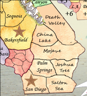
Being a border town (with Arizona) Needles seems abnormally large here and Palm Springs is out of place. You're also lacking the infamous Salton Sea and the one of a kind Joshua Tree NP. I would suggest rearranging this area as such:
Some territory names confuse me. I think:
Morro Bay should be named San Luis Obispo
Solano should be named Richmond
San Luis (near Stockton) should be Contra Costa
I don't think B.K. really works as a stand in for Berkeley. Perhaps you could use the full name and let the end of it bleed into Oakland a little.
As to the graphics, I like the overall look, but feel that a place as flashy as California should have a little more "pop" to it. Something with stronger colors and less of a watercolored look. I like the idea of the coastline background, but maybe something more like this?
Google Image Search for "california sunset" for more inspiration.
 .
.
Also - definitely need the Californian flag (and bear)

Despite all my criticisms, I think you have the start of a very solid map here and I look forward to the next update!
The stunning Channel Islands would be a nice island territory connecting from Santa Barbara.
You've left out the infamous Napa Valley - the most renowned region for growing wine in the US. I think Napa Valley deserves its own territory - set snuggly between Santa Rosa and Sacremento.
Fresno and Inyo Forest should not connect. There are no roads over the Sierras. Instead, I would recommend connecting Modesto and Yosemite (which is actually further West than Inyo Forest).
Death Valley is also in an odd spot and rather small. I can understand the tight fit here, but in reality, the southern border of Death Valley's 3,000 square miles lies north of Bakersfield proper.
Lone Pine is a tiny highway village that only serves as a Portal to Mt. Whitney. Since that area is shown on the map where the northern half of Death Valley should be, I would drop it and just make Death Valley a taller territory. And yes, if you haven't seen it, Death Valley comes right up to the edge of the Sierras. Its one of the most amazing sights I've ever seen.
No Name could be China Lake or China Lake NWC.
Being a border town (with Arizona) Needles seems abnormally large here and Palm Springs is out of place. You're also lacking the infamous Salton Sea and the one of a kind Joshua Tree NP. I would suggest rearranging this area as such:
Some territory names confuse me. I think:
Morro Bay should be named San Luis Obispo
Solano should be named Richmond
San Luis (near Stockton) should be Contra Costa
I don't think B.K. really works as a stand in for Berkeley. Perhaps you could use the full name and let the end of it bleed into Oakland a little.
As to the graphics, I like the overall look, but feel that a place as flashy as California should have a little more "pop" to it. Something with stronger colors and less of a watercolored look. I like the idea of the coastline background, but maybe something more like this?
Google Image Search for "california sunset" for more inspiration.
. Also - definitely need the Californian flag (and bear)
Despite all my criticisms, I think you have the start of a very solid map here and I look forward to the next update!
-

lostatlimbo
- Posts: 1386
- Joined: Wed Mar 28, 2007 3:56 pm
- Location: Portland, OR


Re: California 2.0
![]() by Vlasov on Thu Nov 18, 2010 1:54 am
by Vlasov on Thu Nov 18, 2010 1:54 am
I agree with almost everything in the previous post.
The Channel Islands lie closer to the LA/San Diego coast areas...maybe they could connect to San Diego and/or Malibu/South Bay?
Beverly Hills is actually located south and mostly east of "S.F.V." (San Fernando Valley) -- why not switch their names?
Also, some minor spelling/capitalization issues:
Redwood, not Red Wood
Yosemite, not yosemite
Big Sur, not Big sur
El Dorado, not El Derado
Santa Cruz, not Sant Cruz
-
Vlasov
- Posts: 234
- Joined: Sun Apr 16, 2006 2:45 pm
- Location: Baker's Field
Re: California 2.0
![]() by natty dread on Thu Nov 18, 2010 6:26 pm
by natty dread on Thu Nov 18, 2010 6:26 pm
This is looking quite nice. Some crits:
- the insets look blurry. Quite frankly they look like you just copypasted a part of the map and enlargened it for the insets... I think they are going to need some work.
- not a big fan of the colour scheme. Particularly, northern california looks kinda dirty.
- the title could use some work. It seems a bit too simplistic. Also the inset frames, as well as the brown frame around the map could use some ornamentation. They seem a bit boring now.
Good work otherwise.

-

natty dread
- Posts: 12877
- Joined: Fri Feb 08, 2008 8:58 pm
- Location: just plain fucked


Re: California 2.0
![]() by The Bison King on Fri Nov 19, 2010 5:47 pm
by The Bison King on Fri Nov 19, 2010 5:47 pm
Ok A lot of good feed back It's going to take a bit to address it all. As for the gameplay suggestions that were brought up, I'll be considering some of them but I can't make any promises. Also remember that when it comes to adding territories there are specific start numbers I have to adhere to. Right now I'm at 42 start locations, I can add 2 more territories with out drastically changing the gameplay, but I can't guarantee that I will.
-
The Bison King
- Posts: 1957
- Joined: Thu Aug 27, 2009 5:06 pm
- Location: the Mid-Westeros
Re: California 2.0
![]() by The Bison King on Fri Nov 19, 2010 6:15 pm
by The Bison King on Fri Nov 19, 2010 6:15 pm
The stunning Channel Islands would be a nice island territory connecting from Santa Barbara.
You've left out the infamous Napa Valley - the most renowned region for growing wine in the US. I think Napa Valley deserves its own territory - set snuggly between Santa Rosa and Sacremento.
If I am going to add any territories These would be the two. You'll need to really sell me on why I should add them, not just on a "Because they're there" policy but with some evidence on how it will improve the game play.
Fresno and Inyo Forest should not connect. There are no roads over the Sierras. Instead, I would recommend connecting Modesto and Yosemite (which is actually further West than Inyo Forest).
Where they connect is of little consequence, nor are where the roads are since this isn't a road map. I can definitely switch Yosemite to the hug the mountains on the west though.
Lone Pine is a tiny highway village that only serves as a Portal to Mt. Whitney. Since that area is shown on the map where the northern half of Death Valley should be, I would drop it and just make Death Valley a taller territory. And yes, if you haven't seen it, Death Valley comes right up to the edge of the Sierras. Its one of the most amazing sights I've ever seen.
I don't want to drop Lone pine because I don't want the Sierra Nevada's to be that short on Territories. I have seen that view actually. In fact we sort of have a joke about that. When we were coming up on Death Valley we woke are friend up who was sleeping in the back so that he could see the view. When he checked it out in totally amazement he said "WOW! ... what a shithole!" Ever since then that's kind of been an inside joke between us.
No Name could be China Lake or China Lake NWC.
I actually rather like the name "No Name"
Being a border town (with Arizona) Needles seems abnormally large here and Palm Springs is out of place. You're also lacking the infamous Salton Sea and the one of a kind Joshua Tree NP. I would suggest rearranging this area as such:
I'm not so sure about that re-arrange. It add's both territories and border. I don't want the desert to be that hard to hold.
Also - definitely need the Californian flag (and bear)
I've been trying to ind a way to squeeze it in. I'd like to find a way to add it with out making things too crowded. We'll see.
The Channel Islands lie closer to the LA/San Diego coast areas...maybe they could connect to San Diego and/or Malibu/South Bay?
If I add them maybe they could connect Santa Barbara to Malibu.
Beverly Hills is actually located south and mostly east of "S.F.V." (San Fernando Valley) -- why not switch their names?
With what?
Also, some minor spelling/capitalization issues:
Redwood, not Red Wood
Yosemite, not yosemite
Big Sur, not Big sur
El Dorado, not El Derado
Santa Cruz, not Sant Cruz
Thank you, all incredibly useful.
the insets look blurry. Quite frankly they look like you just copypasted a part of the map and enlargened it for the insets... I think they are going to need some work.
... uh well I did just copy and paste them. There might be a way to make them look sharper in the program. If not I guess I'll just have to re-do them.
not a big fan of the colour scheme. Particularly, northern california looks kinda dirty.
That's more or less an issue of personal preference.
the title could use some work. It seems a bit too simplistic. Also the inset frames, as well as the brown frame around the map could use some ornamentation. They seem a bit boring now.
I completely Agree.
-
The Bison King
- Posts: 1957
- Joined: Thu Aug 27, 2009 5:06 pm
- Location: the Mid-Westeros
Re: California 2.0
![]() by natty dread on Fri Nov 19, 2010 7:39 pm
by natty dread on Fri Nov 19, 2010 7:39 pm
... uh well I did just copy and paste them. There might be a way to make them look sharper in the program. If not I guess I'll just have to re-do them.
See that's not good. You can't just enlarge raster graphics. You will lose detail. Pixels are square, and if you enlargen a bitmap an algorithm is used to resample the pixels into a larger grid - now this may work for simple patterns or gradients, but anything even slightly more detailed and you're going to end up with blurriness and artifacts.
Thus, the general rule with scaling bitmap graphics: downwards = ok, upwards = no-no.
I recommend just redoing them. If you start trying to enhance what you have now, chances are you'll end up doing more work for it...
-
natty dread
- Posts: 12877
- Joined: Fri Feb 08, 2008 8:58 pm
- Location: just plain fucked
Re: California 2.0
![]() by The Bison King on Fri Nov 19, 2010 7:42 pm
by The Bison King on Fri Nov 19, 2010 7:42 pm
natty_dread wrote:... uh well I did just copy and paste them. There might be a way to make them look sharper in the program. If not I guess I'll just have to re-do them.
See that's not good. You can't just enlarge raster graphics. You will lose detail. Pixels are square, and if you enlargen a bitmap an algorithm is used to resample the pixels into a larger grid - now this may work for simple patterns or gradients, but anything even slightly more detailed and you're going to end up with blurriness and artifacts.
Thus, the general rule with scaling bitmap graphics: downwards = ok, upwards = no-no.
I recommend just redoing them. If you start trying to enhance what you have now, chances are you'll end up doing more work for it...
Well... I think If I pull over the inset from the source image it will be large enough. The problem is I scaled it back up from an image I had already shrunk.
-
The Bison King
- Posts: 1957
- Joined: Thu Aug 27, 2009 5:06 pm
- Location: the Mid-Westeros
Re: California 2.0
![]() by natty dread on Fri Nov 19, 2010 8:02 pm
by natty dread on Fri Nov 19, 2010 8:02 pm
The Bison King wrote:Well... I think If I pull over the inset from the source image it will be large enough. The problem is I scaled it back up from an image I had already shrunk.
Yes, try that. And if that fails you can always rescan your painting with a larger dpi.
-
natty dread
- Posts: 12877
- Joined: Fri Feb 08, 2008 8:58 pm
- Location: just plain fucked
Re: California 2.0
![]() by lostatlimbo on Sat Nov 20, 2010 7:57 pm
by lostatlimbo on Sat Nov 20, 2010 7:57 pm
The Bison King wrote:If I am going to add any territories These would be the two. You'll need to really sell me on why I should add them, not just on a "Because they're there" policy but with some evidence on how it will improve the game play.
Its not just because they exist, but because these two places are part of California's identity. People all over the world are familiar with wines from the Napa Valley. The Channel Islands are somewhat less famous, but represent the marine diversity and scenic beauty that the golden state is known for.
If you are reluctant to add territories, you could skip the Islands and just rename Santa Rosa to "Napa Valley" instead.
The Bison King wrote:I don't want to drop Lone pine because I don't want the Sierra Nevada's to be that short on Territories.
That's a fair point. If you are going to leave that territory as is, may I suggest you name it "Mt. Whitney" or "Whitney Portal" instead? Its the tallest peak in the contiguous US and Lone Pine wouldn't exist without it.
The Bison King wrote:Where they connect is of little consequence, nor are where the roads are since this isn't a road map. I can definitely switch Yosemite to the hug the mountains on the west though.
It may not be a road map, but it looks odd to have a giant gap in the Sierra mountains, especially there. If you're trying to represent the state, it just doesn't make sense to me to have passage through the most impassable part of the Sierra range.
If you look at the Europa map you don't see unexplained holes in the Alps. Nor with the Himalayas in Asia.
Modesto <> Yosemite just makes more sense and I don't think it would alter gameplay much.
$.02
-
lostatlimbo
- Posts: 1386
- Joined: Wed Mar 28, 2007 3:56 pm
- Location: Portland, OR
Who is online
Users browsing this forum: LittleMao
|
|||||||
| Conquer Club is not associated with RISK online in any way. Copyright © 2006-2024 by Big Wham LLC | |||||||