Conquer Club

First Nations Americas.

Care to peruse completed maps? Take a stroll through the Atlas.

Moderator: Cartographers

Forum rules
Please read the Community Guidelines before posting.

Re: First Nations combined

Postby Tisha on Sun Jan 30, 2011 2:21 pm

isaiah40 wrote:
Tisha wrote:I changes the title, and the names of the ships.

what else?

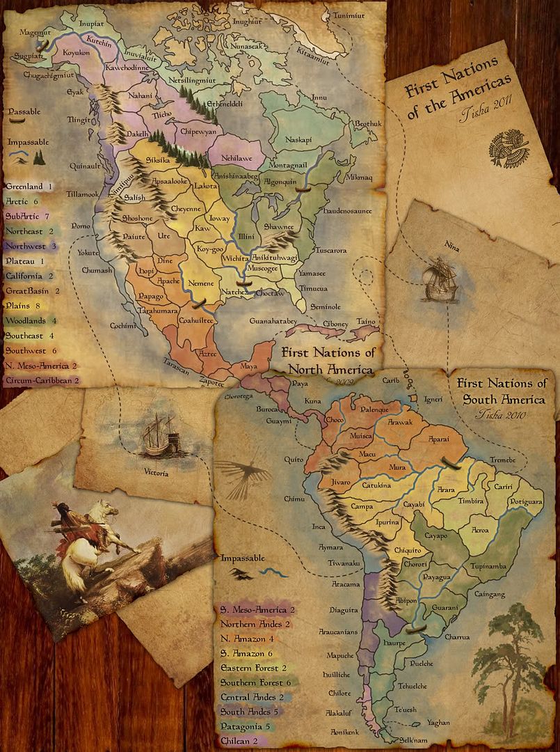
1)Make South Meso-America 3?
2)what about where the two meso americas meet? draw a border right on the edge of the paper?

3)connect the Victoria to Tarascan?

4)neutrals on the boats and Nimiipuu?


1) I would be more inclined to increase North Meso America by 1 - see point 3 ;)


2)I'd say draw the line on the edge of the paper to divide the two meso americas to avoid any confusion.

3)Yes connect the Victoria to Tarascan.

4)2 neutrals on the boats and 3 on Nimiipuu.

well then I would wanna increase south by one also, since they both have three borders, and the south has one more territory than the north.
User avatar
Major Tisha
 
Posts: 1065
Joined: Sat Dec 23, 2006 12:41 am

Re: First Nations combined

Postby neanderpaul14 on Sun Jan 30, 2011 4:26 pm

=D> =D> =D>

Looks awesome.....can't wait to play it.
Image
High score: 2724
/#163 on scoreboard/COLONEL
User avatar
Cook neanderpaul14
 
Posts: 1216
Joined: Wed Aug 06, 2008 3:52 pm
Location: "Always mystify, mislead and surprise the enemy if possible." - Thomas J. Jackson

Re: First Nations combined

Postby Industrial Helix on Sun Jan 30, 2011 4:51 pm

MrBenn wrote:"On August 3, 1492, Christopher Columbus set sail from Spain with three small Spanish sailing ships, the Pinta, the Niña, and the Santa María"


Yes, but the Niña was his favorite.

So i still vote call it the Niña or find an image with 3 ships and call it the Niña, the Pinta and the Santa María.
Sketchblog [Update 07/25/11]: http://indyhelixsketch.blogspot.com/
Living in Japan [Update 07/17/11]: http://mirrorcountryih.blogspot.com/
Russian Revolution map for ConquerClub [07/20/11]: viewtopic.php?f=241&t=116575
User avatar
Cook Industrial Helix
 
Posts: 3462
Joined: Mon Jul 14, 2008 6:49 pm
Location: Ohio

Re: First Nations combined

Postby benga on Sun Jan 30, 2011 5:08 pm

Go for it, looks beautiful!

Can't wait!!
User avatar
Sergeant benga
 
Posts: 6925
Joined: Tue Nov 17, 2009 4:15 pm

Re: First Nations combined

Postby Tisha on Sun Jan 30, 2011 6:44 pm

Industrial Helix wrote:
MrBenn wrote:"On August 3, 1492, Christopher Columbus set sail from Spain with three small Spanish sailing ships, the Pinta, the Niña, and the Santa María"


Yes, but the Niña was his favorite.

So i still vote call it the Niña or find an image with 3 ships and call it the Niña, the Pinta and the Santa María.

the Nina is the only one that made the complete trip.. he started out on the Santa Maria..

same as the Victoria, the guy started out on the Trinidad.. but it didn't work out so well..


I picked Victoria and Nina.
User avatar
Major Tisha
 
Posts: 1065
Joined: Sat Dec 23, 2006 12:41 am

Re: First Nations combined

Postby lostatlimbo on Sun Jan 30, 2011 6:55 pm

This looks awesome. Hope it makes it through foundry quickly, since the maps are already established.
User avatar
Sergeant 1st Class lostatlimbo
 
Posts: 1386
Joined: Wed Mar 28, 2007 3:56 pm
Location: Portland, OR

Re: First Nations combined

Postby natty dread on Sun Jan 30, 2011 7:03 pm

Did you seriously use the words "foundry" and "quickly" in the same sentence?
Image
User avatar
Sergeant 1st Class natty dread
 
Posts: 12877
Joined: Fri Feb 08, 2008 8:58 pm
Location: just plain fucked

Re: First Nations combined

Postby MrBenn on Sun Jan 30, 2011 7:24 pm

Tisha wrote:what about where the two meso americas meet? draw a border right on the edge of the paper?

You shouldn;t need to draw a border at all; if you want to enhance it, just add slightly more shadow where the pages overlap. This should be more than sufficient.

isaiah40 wrote:
Tisha wrote:3)connect the Victoria to Tarascan?

4)neutrals on the boats and Nimiipuu?

3)Yes connect the Victoria to Tarascan.

Actually, I would suggest reverting back to something almost like you had originally for the connections on the Pacific ocean side of the map. With the proximity of the connections across both sides of the map, the Meso-Americas become even more of a bottle neck; having the cross-map connections converging in the middle sort-of defeats the point of adding them in the first place?

If the path across the sea is redrawn to go beneath the bird and around it to the left, then it would be a better approximation of actual established sea trading routes. I'd take the path from Diaguita to Romo to reflect actual sailing routes:
Image
Image
PB: 2661 | He's blue... If he were green he would die | No mod would be stupid enough to do that
User avatar
Lieutenant MrBenn
 
Posts: 6880
Joined: Wed Nov 21, 2007 9:32 am
Location: Off Duty

Re: First Nations combined

Postby Tisha on Sun Jan 30, 2011 7:50 pm

MrBenn wrote:Actually, I would suggest reverting back to something almost like you had originally for the connections on the Pacific ocean side of the map. With the proximity of the connections across both sides of the map, the Meso-Americas become even more of a bottle neck; having the cross-map connections converging in the middle sort-of defeats the point of adding them in the first place?

If the path across the sea is redrawn to go beneath the bird and around it to the left, then it would be a better approximation of actual established sea trading routes. I'd take the path from Diaguita to Romo to reflect actual sailing routes:
Image


I don't understand? :oops:

the left of the bird, I got.

two connections from Victoria? Maybe just Chumash and Chimu?
User avatar
Major Tisha
 
Posts: 1065
Joined: Sat Dec 23, 2006 12:41 am

Re: First Nations combined

Postby Victor Sullivan on Mon Jan 31, 2011 6:10 am

Victor Sullivan wrote:3. For the title, might I suggest "First Nations of the Americas"? That way it will be next to the other two First Nations maps in the game finder.

Industrial Helix wrote:Also... the title seems strange to me. What about simply "First Nations of the Americas."

Thanks, IH, just in case she didn't get it the first time, lol...

Would you mind posting your updated map so far, Tisha? It sounds like you've been making the changes, but it'd be nice to see them as you go.

-Sully
User avatar
Corporal Victor Sullivan
 
Posts: 6010
Joined: Mon Feb 08, 2010 8:17 pm
Location: Columbus, OH

Re: First Nations combined

Postby Tisha on Mon Jan 31, 2011 11:32 am

Click image to enlarge.
image
User avatar
Major Tisha
 
Posts: 1065
Joined: Sat Dec 23, 2006 12:41 am

Re: First Nations combined

Postby isaiah40 on Mon Jan 31, 2011 12:47 pm

MrBenn wrote:Actually, I would suggest reverting back to something almost like you had originally for the connections on the Pacific ocean side of the map. With the proximity of the connections across both sides of the map, the Meso-Americas become even more of a bottle neck; having the cross-map connections converging in the middle sort-of defeats the point of adding them in the first place?


Okay I see what Mr.Benn is talking about now.

You shouldn;t need to draw a border at all; if you want to enhance it, just add slightly more shadow where the pages overlap. This should be more than sufficient.


Or you can do what he said :D

This is just a nit pick - do you need your name on both halves? Doesn't matter either way.
Lieutenant isaiah40
 
Posts: 3990
Joined: Mon Aug 27, 2007 7:14 pm

Re: First Nations combined

Postby Tisha on Mon Jan 31, 2011 2:27 pm

isaiah40 wrote:
MrBenn wrote:Actually, I would suggest reverting back to something almost like you had originally for the connections on the Pacific ocean side of the map. With the proximity of the connections across both sides of the map, the Meso-Americas become even more of a bottle neck; having the cross-map connections converging in the middle sort-of defeats the point of adding them in the first place?


Okay I see what Mr.Benn is talking about now.

You shouldn;t need to draw a border at all; if you want to enhance it, just add slightly more shadow where the pages overlap. This should be more than sufficient.


Or you can do what he said :D

This is just a nit pick - do you need your name on both halves? Doesn't matter either way.


yes, I do
Image
User avatar
Major Tisha
 
Posts: 1065
Joined: Sat Dec 23, 2006 12:41 am

Re: First Nations combined

Postby MrBenn on Mon Jan 31, 2011 3:56 pm

Tisha wrote:two connections from Victoria? Maybe just Chumash and Chimu?

MrBenn wrote: I'd take the path from Diaguita to Romo to reflect actual sailing routes:

Having the connecting territories further apart makes the Meso-Americas slightly more defensible, and a better place to start. Diaguita in the South and Pomo in the North would be suitable ;-)
Image
PB: 2661 | He's blue... If he were green he would die | No mod would be stupid enough to do that
User avatar
Lieutenant MrBenn
 
Posts: 6880
Joined: Wed Nov 21, 2007 9:32 am
Location: Off Duty

Re: First Nations combined. Update pg. 3

Postby Tisha on Mon Jan 31, 2011 6:19 pm

good connections?

Click image to enlarge.
image
User avatar
Major Tisha
 
Posts: 1065
Joined: Sat Dec 23, 2006 12:41 am

Re: First Nations combined. Update pg. 3

Postby MrBenn on Tue Feb 01, 2011 6:52 am

Yes, that looks better.

Part of me wonders whether Carib. and Ignerri on the Southern map should be absorbed into the Circum-Caribbean bonus on the Northern map, but I think that would be difficult to represent (even if it were a more natural grouping).

On a graphical note, I wonder if the two ships should be rotated to align properly with the paper (like you've done with their names)?
Image
PB: 2661 | He's blue... If he were green he would die | No mod would be stupid enough to do that
User avatar
Lieutenant MrBenn
 
Posts: 6880
Joined: Wed Nov 21, 2007 9:32 am
Location: Off Duty

Re: First Nations combined. Update pg. 3

Postby Ace Rimmer on Tue Feb 01, 2011 10:16 am

I came.
User avatar
Lieutenant Ace Rimmer
 
Posts: 1911
Joined: Mon Dec 01, 2008 1:22 pm

Re: First Nations combined. Update pg. 3

Postby Bruceswar on Tue Feb 01, 2011 10:35 am

jakewilliams wrote:I came.


:lol: :lol: :lol: :lol: =D> =D> =D> =D>

I cannot wait for this one to be out!
Highest Rank: 26 Highest Score: 3480
Image
User avatar
Corporal Bruceswar
 
Posts: 9713
Joined: Sun Dec 23, 2007 12:36 am
Location: Cow Pastures

Re: First Nations combined. Update pg. 3

Postby sdh on Tue Feb 01, 2011 10:40 am

looks fantastic
Major sdh
 
Posts: 1650
Joined: Sun Apr 05, 2009 7:43 am
234

Re: First Nations combined. Update pg. 3

Postby phantomzero on Tue Feb 01, 2011 1:09 pm

Fantastic! QUENCH!!!
Image
User avatar
Sergeant 1st Class phantomzero
 
Posts: 827
Joined: Fri Dec 28, 2007 7:13 pm
Location: 2742 high score 122710

Re: First Nations combined. Update pg. 3

Postby Industrial Helix on Tue Feb 01, 2011 2:45 pm

Can we get Niña and Victoria right under the ships?

And the second n in Niña ought to have a tilde.
Sketchblog [Update 07/25/11]: http://indyhelixsketch.blogspot.com/
Living in Japan [Update 07/17/11]: http://mirrorcountryih.blogspot.com/
Russian Revolution map for ConquerClub [07/20/11]: viewtopic.php?f=241&t=116575
User avatar
Cook Industrial Helix
 
Posts: 3462
Joined: Mon Jul 14, 2008 6:49 pm
Location: Ohio

Re: First Nations combined. Update pg. 3

Postby Peter Gibbons on Tue Feb 01, 2011 3:01 pm

Beautiful combination. Will be a wonderful addition. Great idea to combine two beautiful existing maps to use under the new size allowances (I wonder... would the USA Interstate pack be next?).

Anyway only one gameplay suggestion/question right now...

Would a +1 bonus for holding both ships be in order? Or possibly a +1 auto-deploy on either? If neither suggestion ends up being in favor, should there be a place on the map that says the ships are "not part of any bonus" like the Sea of Japan territory on the Japan map?
User avatar
Major Peter Gibbons
 
Posts: 1077
Joined: Wed Sep 10, 2008 9:21 am
Location: Washington, DC

Re: First Nations combined. Update pg. 3

Postby Tisha on Tue Feb 01, 2011 4:28 pm

I moved the names a little closer, tilted the ships.

what are we doing with Neutrals? ship ship and Nimiipuu?

MrBenn wrote:
Part of me wonders whether Carib. and Ignerri on the Southern map should be absorbed into the Circum-Caribbean bonus on the Northern map, but I think that would be difficult to represent (even if it were a more natural grouping).


I would like to add those to the other bonus MrBenn, but now sure how that would work..
User avatar
Major Tisha
 
Posts: 1065
Joined: Sat Dec 23, 2006 12:41 am

Re: First Nations combined. Update pg. 3

Postby Industrial Helix on Tue Feb 01, 2011 5:48 pm

I don't see why the ships ought to be neutrals. Let them deploy like every other territory. Nimiipuu should remain a neutral, as it is on FNoNA.

Where there any other starting neutrals on the other maps?
Sketchblog [Update 07/25/11]: http://indyhelixsketch.blogspot.com/
Living in Japan [Update 07/17/11]: http://mirrorcountryih.blogspot.com/
Russian Revolution map for ConquerClub [07/20/11]: viewtopic.php?f=241&t=116575
User avatar
Cook Industrial Helix
 
Posts: 3462
Joined: Mon Jul 14, 2008 6:49 pm
Location: Ohio

Re: First Nations combined. Update pg. 3

Postby theBastard on Tue Feb 01, 2011 7:43 pm

I agree to add ships as neutral. and also Nimiipuu and Salish.
User avatar
Corporal 1st Class theBastard
 
Posts: 994
Joined: Sat Jan 09, 2010 9:05 am

PreviousNext

Return to The Atlas

Who is online

Users browsing this forum: No registered users

cron