Re: Ethiopia: [27.12.12] V06-P3 Gameplay?
x-raider wrote:cairnswk wrote:How many extra bonuses were you thinking of it the extras were kept?
I'm talking about the ones you got there already.
Suggestions?
Conquer Club, a free online multiplayer variation of a popular world domination board game.
https://www.conquerclub.com/forum/
https://www.conquerclub.com/forum/viewtopic.php?f=358&t=174289
x-raider wrote:cairnswk wrote:How many extra bonuses were you thinking of it the extras were kept?
I'm talking about the ones you got there already.
ManBungalow wrote:Right, I wouldn't bother with the cattle or the faith bonuses. The coffee you could have, I suppose. Maybe adapted slightly.
And I see that you have already worked out the number of starting regions, but I think it would be cool if the neighbouring countries started neutral.
cairnswk wrote:ManBungalow wrote:Right, I wouldn't bother with the cattle or the faith bonuses. The coffee you could have, I suppose. Maybe adapted slightly.
Well all three are very typically Ethiopian....how would adapt the coffee bonus...idea?
cairnswk wrote:And I see that you have already worked out the number of starting regions, but I think it would be cool if the neighbouring countries started neutral.
Cool...why...what are your reasons here please?
ManBungalow wrote:cairnswk wrote:ManBungalow wrote:Right, I wouldn't bother with the cattle or the faith bonuses. The coffee you could have, I suppose. Maybe adapted slightly.
Well all three are very typically Ethiopian....how would adapt the coffee bonus...idea?
You could spread them over the map. But see if anybody else can offer any ideas here.cairnswk wrote:And I see that you have already worked out the number of starting regions, but I think it would be cool if the neighbouring countries started neutral.
Cool...why...what are your reasons here please?
For one thing, they're not actually Ethiopia. And they offer quick links to bonuses on the other side of the map...really powerful borders.
nolefan5311 wrote:I just got back from a long vacation and still trying to get my bearings back, so bear with me, but I don't like the new bonuses at all. They clutter the space up and are going to require a lot more neutrals to be placed around the map.
Good to see this one back into production though
cairnswk wrote:nolefan5311 wrote:I just got back from a long vacation and still trying to get my bearings back, so bear with me
Good to see this one back into production though
OK, are any of them useful? or should they be excised completely and leave the map as simple as possible.
x-raider wrote:cairnswk wrote:x-raider wrote:Aw, why'd you have to go ruin it like that.
Either make it a small-size map or give it a bunch of extra bonuses.
You needn't do both.
Well, x-raider, i haven't exactly ruined it...yet!
It is reversible if people don't like it.
So thanks for you feedback on that.
Sure.
But I can't ask people to support my opinion if I don't voice it now, can I?
nolefan5311 wrote:cairnswk wrote:nolefan5311 wrote:I just got back from a long vacation and still trying to get my bearings back, so bear with me
Good to see this one back into production though
OK, are any of them useful? or should they be excised completely and leave the map as simple as possible.
That is probably what I would do.
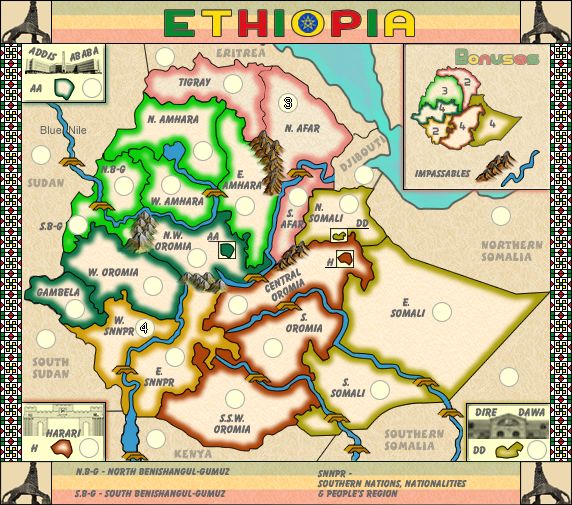
x-raider wrote:You still need to include the impassable legend.
I suggest putting it above the bonus legend.
As can be seen in N.W.Oromia, the mountains could do with a touch up so they blend with the map and the colours better.
And the rivers are largely inconsistent...
Good luck
Sorry your previous changes didn't go down well.
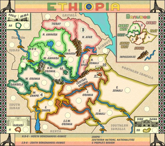
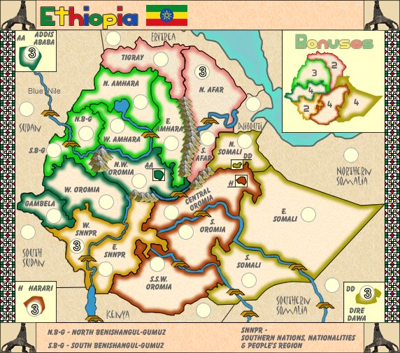
nolefan5311 wrote:cairns, I will go ahead and sticky this one for the stamp, but I suggest removing the neutral starts from all the capitals since they don't have any significance (that I can see) other than increasing some of the 3 region bonuses to 4. 27 starting regions is also a golden number and in 1v1 games increases the amount of starting regions per player from 8 to 9 which I prefer on a map this small. Also, in the continents the capitals are in, you don't need to worry about bonus dropping since all those continents are 4 regions. As long as N. Afar and W. Snnpr start neutrals, there's no need for any other to.
...
cairnswk wrote:nolefan5311 wrote:cairns, I will go ahead and sticky this one for the stamp, but I suggest removing the neutral starts from all the capitals since they don't have any significance (that I can see) other than increasing some of the 3 region bonuses to 4. 27 starting regions is also a golden number and in 1v1 games increases the amount of starting regions per player from 8 to 9 which I prefer on a map this small. Also, in the continents the capitals are in, you don't need to worry about bonus dropping since all those continents are 4 regions. As long as N. Afar and W. Snnpr start neutrals, there's no need for any other to.
...
OK, but is there any need to increase the amount of each neutral in those territories i.e. once SNNPR is taken it's an easy +2 to add to any player's army.
nolefan5311 wrote:cairnswk wrote:nolefan5311 wrote:cairns, I will go ahead and sticky this one for the stamp, but I suggest removing the neutral starts from all the capitals since they don't have any significance (that I can see) other than increasing some of the 3 region bonuses to 4. 27 starting regions is also a golden number and in 1v1 games increases the amount of starting regions per player from 8 to 9 which I prefer on a map this small. Also, in the continents the capitals are in, you don't need to worry about bonus dropping since all those continents are 4 regions. As long as N. Afar and W. Snnpr start neutrals, there's no need for any other to.
...
OK, but is there any need to increase the amount of each neutral in those territories i.e. once SNNPR is taken it's an easy +2 to add to any player's army.
You could increase it to a n4 if you'd like. ian and I discussed this and came to the conclusion that if there are not starting neutrals in the larger continents, players my focus on grabbing one of those and not dedicate troops to the smaller bonus. But making it a n4 won't hurt anything.
nolefan5311 wrote:cairns, I will go ahead and sticky this one for the stamp, but I suggest removing the neutral starts from all the capitals since they don't have any significance (that I can see) other than increasing some of the 3 region bonuses to 4. 27 starting regions is also a golden number and in 1v1 games increases the amount of starting regions per player from 8 to 9 which I prefer on a map this small. Also, in the continents the capitals are in, you don't need to worry about bonus dropping since all those continents are 4 regions. As long as N. Afar and W. Snnpr start neutrals, there's no need for any other to.
If anybody else has any suggestions, now is the time to speak up. Otherwise, this map will receive the gameplay stamp in 48-72 hours.

nolefan5311 wrote:
Onwards and upwards cairns. Congrats.
RedBaron0 wrote:First impressions: The map colors are kinda bright for me, especially for a desert country. Some more earthy tones would be quite good for me, personally, but the rest of the community will likely have a say as well.
Question, where is the border between Sudan and South Sudan?
Also I assume Kenya and South Sudan are adjacent, yes? There is a border line from the box from H Harari to W. Snnpr that oddly separates nothing and calls into question what connects to what exactly.
There is an odd blank patch near the mountains in S.B-G
The word "bonuses" in the legend minimap seems kinda redundant to me, do correct me if I'm wrong here community!
Also a question to that, are the cities within regions a part of their respective bonus? if necessary a pit of explination to that may be required.
Oh, and do the bonuses have names themselves?