[Official] Germany Revamp
Subject: Germany Revamp
WidowMakers wrote:Updates:1) Carto Sigs (Hoff, Pepe, WM)
2) Fix mini map Yellow/Brown Border
3) Tweak mini map text outer glows
Large V3
- Click image to enlarge.
Small V3
- Click image to enlarge.
---------
LARGE V2
http://img695.imageshack.us/img695/7417 ... mpv09l.png
SMALL V2
http://img96.imageshack.us/img96/6797/g ... mpv09s.png


pepperonibread wrote:Latest Update (see pg. 21 for more info):
- Click image to enlarge.
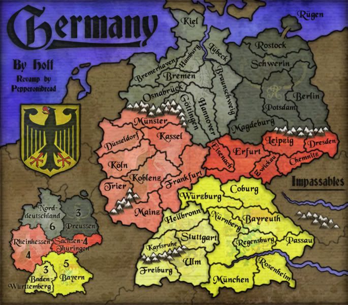
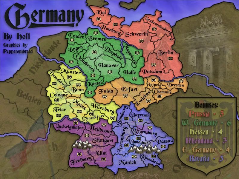
About the Revamp:Hey everybody. More than other maps, revamps like this have certain restrictions on how they are developed. One of the most important of these is that a revamp cannot change the "gameplay" of the map being revamped. Basically, which territories border which other territories and which continents they are contained in must remain the same as in the original map.
Take the dark gray continent Preussen (the red continent Prussia in the old map). If you take a look at the two maps, you can see that each territory on the old map directly corresponds to one territory on the new map. For example, Potsdam on the old map, bordering three territories of other continents and two in its own, is equivalent to Magdeburg on the new map, which has the same border configuration. Dresden on the old map, which borders three territories in its own continent, corresponds to Potsdam on the new map, which also has these borders.
Here are a few more examples to clarify:
Old map's Donrath = New map's Koblenz
Old map's Erfurt = New map's Zwickau
Old map's Augsburg = New map's Bayreuth
Old map's Niedersachsen = New map's Bremen
etc.
In this way, while names have been changed and border shapes have been altered, the gameplay of the map remains identical. So if I want to make the map more accurate, I have to make sure that there are no gameplay changes while I edit it.
If everyone could try and make sure that their suggestions don't break any of these "rules", that would be great
Map Stats:
-# of territories: 42
-# of continents: 6
-Features: Rivers and mountains are impassable, bridges allow attacks over rivers.
Previous Versions:
June 30, Page 20
April 6, Page 20
January 24, Page 18
December 22, Page 16
December 20, Page 15
October 10, Page 15
August 13, Page 13
August 10, Page 12
July 10, Page 10
July 4, Page 9
June 22, Page 8
Stamps:
Current XML (link - http://h1.ripway.com/pepperonibread/Germany.xml):
- Code: Select all
<?xml version="1.0" ?>
<map>
<title>Germany</title>
<smallwidth>580</smallwidth>
<smallheight>508</smallheight>
<largewidth>685</largewidth>
<largeheight>600</largeheight>
<filetype>jpg</filetype>
<continent>
<name>Bayern</name>
<bonus>5</bonus>
<components>
<territory>Coburg</territory>
<territory>Würzburg</territory>
<territory>Bayreuth</territory>
<territory>Nürnberg</territory>
<territory>Regensburg</territory>
<territory>Passau</territory>
<territory>München</territory>
<territory>Rosenheim</territory>
</components>
</continent>
<continent>
<name>Sachsen-Thüringen</name>
<bonus>4</bonus>
<components>
<territory>Eisenach</territory>
<territory>Erfurt</territory>
<territory>Leipzig</territory>
<territory>Zwickau</territory>
<territory>Dresden</territory>
<territory>Chemnitz</territory>
</components>
</continent>
<continent>
<name>Preussen</name>
<bonus>3</bonus>
<components>
<territory>Magdeburg</territory>
<territory>Potsdam</territory>
<territory>Schwerin</territory>
<territory>Berlin</territory>
<territory>Rostock</territory>
<territory>Rügen</territory>
</components>
</continent>
<continent>
<name>Norddeutschland</name>
<bonus>6</bonus>
<components>
<territory>Braunschweig</territory>
<territory>Hannover</territory>
<territory>Gottingen</territory>
<territory>Osnabrück</territory>
<territory>Bremen</territory>
<territory>Lübeck</territory>
<territory>Hamburg</territory>
<territory>Bremerhaven</territory>
<territory>Kiel</territory>
</components>
</continent>
<continent>
<name>Baden-Württemberg</name>
<bonus>3</bonus>
<components>
<territory>Heilbronn</territory>
<territory>Stuttgart</territory>
<territory>Karlsruhe</territory>
<territory>Ulm</territory>
<territory>Freiburg</territory>
</components>
</continent>
<continent>
<name>Rheinhessen</name>
<bonus>4</bonus>
<components>
<territory>Frankfurt</territory>
<territory>Mainz</territory>
<territory>Koblenz</territory>
<territory>Kassel</territory>
<territory>Münster</territory>
<territory>Düsseldorf</territory>
<territory>Köln</territory>
<territory>Trier</territory>
</components>
</continent>
<territory>
<name>Rügen</name>
<borders>
<border>Rostock</border>
</borders>
<coordinates>
<smallx>479</smallx>
<smally>59</smally>
<largex>568</largex>
<largey>66</largey>
</coordinates>
</territory>
<territory>
<name>Rostock</name>
<borders>
<border>Rügen</border>
<border>Schwerin</border>
</borders>
<coordinates>
<smallx>447</smallx>
<smally>83</smally>
<largex>528</largex>
<largey>95</largey>
</coordinates>
</territory>
<territory>
<name>Schwerin</name>
<borders>
<border>Rostock</border>
<border>Lübeck</border>
<border>Braunschweig</border>
<border>Berlin</border>
<border>Potsdam</border>
<border>Magdeburg</border>
</borders>
<coordinates>
<smallx>399</smallx>
<smally>122</smally>
<largex>472</largex>
<largey>140</largey>
</coordinates>
</territory>
<territory>
<name>Berlin</name>
<borders>
<border>Schwerin</border>
<border>Potsdam</border>
</borders>
<coordinates>
<smallx>516</smallx>
<smally>204</smally>
<largex>611</largex>
<largey>236</largey>
</coordinates>
</territory>
<territory>
<name>Potsdam</name>
<borders>
<border>Berlin</border>
<border>Schwerin</border>
<border>Magdeburg</border>
</borders>
<coordinates>
<smallx>455</smallx>
<smally>172</smally>
<largex>539</largex>
<largey>199</largey>
</coordinates>
</territory>
<territory>
<name>Magdeburg</name>
<borders>
<border>Schwerin</border>
<border>Potsdam</border>
<border>Leipzig</border>
<border>Erfurt</border>
<border>Braunschweig</border>
</borders>
<coordinates>
<smallx>412</smallx>
<smally>201</smally>
<largex>488</largex>
<largey>231</largey>
</coordinates>
</territory>
<territory>
<name>Dresden</name>
<borders>
<border>Chemnitz</border>
<border>Leipzig</border>
</borders>
<coordinates>
<smallx>547</smallx>
<smally>269</smally>
<largex>647</largex>
<largey>313</largey>
</coordinates>
</territory>
<territory>
<name>Chemnitz</name>
<borders>
<border>Dresden</border>
<border>Zwickau</border>
<border>Leipzig</border>
</borders>
<coordinates>
<smallx>469</smallx>
<smally>296</smally>
<largex>555</largex>
<largey>349</largey>
</coordinates>
</territory>
<territory>
<name>Leipzig</name>
<borders>
<border>Dresden</border>
<border>Zwickau</border>
<border>Erfurt</border>
<border>Magdeburg</border>
<border>Chemnitz</border>
</borders>
<coordinates>
<smallx>471</smallx>
<smally>270</smally>
<largex>557</largex>
<largey>315</largey>
</coordinates>
</territory>
<territory>
<name>Zwickau</name>
<borders>
<border>Erfurt</border>
<border>Leipzig</border>
<border>Chemnitz</border>
<border>Coburg</border>
</borders>
<coordinates>
<smallx>448</smallx>
<smally>307</smally>
<largex>530</largex>
<largey>360</largey>
</coordinates>
</territory>
<territory>
<name>Erfurt</name>
<borders>
<border>Leipzig</border>
<border>Zwickau</border>
<border>Coburg</border>
<border>Würzburg</border>
<border>Frankfurt</border>
<border>Eisenach</border>
<border>Hannover</border>
<border>Braunschweig</border>
<border>Magdeburg</border>
</borders>
<coordinates>
<smallx>403</smallx>
<smally>296</smally>
<largex>478</largex>
<largey>345</largey>
</coordinates>
</territory>
<territory>
<name>Eisenach</name>
<borders>
<border>Gottingen</border>
<border>Hannover</border>
<border>Erfurt</border>
<border>Frankfurt</border>
</borders>
<coordinates>
<smallx>352</smallx>
<smally>291</smally>
<largex>416</largex>
<largey>341</largey>
</coordinates>
</territory>
<territory>
<name>Kiel</name>
<borders>
<border>Hamburg</border>
<border>Bremerhaven</border>
</borders>
<coordinates>
<smallx>311</smallx>
<smally>77</smally>
<largex>371</largex>
<largey>87</largey>
</coordinates>
</territory>
<territory>
<name>Bremerhaven</name>
<borders>
<border>Kiel</border>
<border>Bremen</border>
<border>Osnabrück</border>
<border>Hamburg</border>
</borders>
<coordinates>
<smallx>237</smallx>
<smally>127</smally>
<largex>281</largex>
<largey>148</largey>
</coordinates>
</territory>
<territory>
<name>Gottingen</name>
<borders>
<border>Osnabrück</border>
<border>Hannover</border>
<border>Eisenach</border>
<border>Frankfurt</border>
<border>Kassel</border>
</borders>
<coordinates>
<smallx>329</smallx>
<smally>251</smally>
<largex>388</largex>
<largey>290</largey>
</coordinates>
</territory>
<territory>
<name>Hannover</name>
<borders>
<border>Gottingen</border>
<border>Osnabrück</border>
<border>Bremen</border>
<border>Braunschweig</border>
<border>Erfurt</border>
<border>Eisenach</border>
</borders>
<coordinates>
<smallx>328</smallx>
<smally>177</smally>
<largex>387</largex>
<largey>204</largey>
</coordinates>
</territory>
<territory>
<name>Braunschweig</name>
<borders>
<border>Hannover</border>
<border>Bremen</border>
<border>Lübeck</border>
<border>Schwerin</border>
<border>Magdeburg</border>
<border>Erfurt</border>
</borders>
<coordinates>
<smallx>383</smallx>
<smally>154</smally>
<largex>434</largex>
<largey>234</largey>
</coordinates>
</territory>
<territory>
<name>Lübeck</name>
<borders>
<border>Schwerin</border>
<border>Braunschweig</border>
</borders>
<coordinates>
<smallx>356</smallx>
<smally>85</smally>
<largex>422</largex>
<largey>96</largey>
</coordinates>
</territory>
<territory>
<name>Bremen</name>
<borders>
<border>Braunschweig</border>
<border>Hannover</border>
<border>Osnabrück</border>
<border>Bremerhaven</border>
<border>Hamburg</border>
</borders>
<coordinates>
<smallx>336</smallx>
<smally>151</smally>
<largex>397</largex>
<largey>175</largey>
</coordinates>
</territory>
<territory>
<name>Hamburg</name>
<borders>
<border>Bremen</border>
<border>Kiel</border>
<border>Bremerhaven</border>
</borders>
<coordinates>
<smallx>323</smallx>
<smally>123</smally>
<largex>382</largex>
<largey>143</largey>
</coordinates>
</territory>
<territory>
<name>Münster</name>
<borders>
<border>Düsseldorf</border>
<border>Kassel</border>
</borders>
<coordinates>
<smallx>210</smallx>
<smally>216</smally>
<largex>248</largex>
<largey>252</largey>
</coordinates>
</territory>
<territory>
<name>Düsseldorf</name>
<borders>
<border>Münster</border>
<border>Kassel</border>
<border>Köln</border>
</borders>
<coordinates>
<smallx>184</smallx>
<smally>244</smally>
<largex>219</largex>
<largey>285</largey>
</coordinates>
</territory>
<territory>
<name>Köln</name>
<borders>
<border>Düsseldorf</border>
<border>Kassel</border>
<border>Koblenz</border>
<border>Trier</border>
</borders>
<coordinates>
<smallx>224</smallx>
<smally>283</smally>
<largex>264</largex>
<largey>331</largey>
</coordinates>
</territory>
<territory>
<name>Trier</name>
<borders>
<border>Köln</border>
<border>Koblenz</border>
</borders>
<coordinates>
<smallx>190</smallx>
<smally>346</smally>
<largex>224</largex>
<largey>405</largey>
</coordinates>
</territory>
<territory>
<name>Koblenz</name>
<borders>
<border>Trier</border>
<border>Köln</border>
<border>Kassel</border>
<border>Frankfurt</border>
<border>Mainz</border>
</borders>
<coordinates>
<smallx>260</smallx>
<smally>300</smally>
<largex>307</largex>
<largey>352</largey>
</coordinates>
</territory>
<territory>
<name>Mainz</name>
<borders>
<border>Koblenz</border>
<border>Frankfurt</border>
<border>Heilbronn</border>
</borders>
<coordinates>
<smallx>247</smallx>
<smally>392</smally>
<largex>293</largex>
<largey>457</largey>
</coordinates>
</territory>
<territory>
<name>Heilbronn</name>
<borders>
<border>Mainz</border>
<border>Frankfurt</border>
<border>Würzburg</border>
<border>Nürnberg</border>
<border>Stuttgart</border>
<border>Karlsruhe</border>
</borders>
<coordinates>
<smallx>308</smallx>
<smally>394</smally>
<largex>361</largex>
<largey>462</largey>
</coordinates>
</territory>
<territory>
<name>Karlsruhe</name>
<borders>
<border>Heilbronn</border>
<border>Stuttgart</border>
</borders>
<coordinates>
<smallx>278</smallx>
<smally>418</smally>
<largex>329</largex>
<largey>489</largey>
</coordinates>
</territory>
<territory>
<name>Stuttgart</name>
<borders>
<border>Karlsruhe</border>
<border>Heilbronn</border>
<border>Nürnberg</border>
<border>Ulm</border>
</borders>
<coordinates>
<smallx>337</smallx>
<smally>404</smally>
<largex>398</largex>
<largey>472</largey>
</coordinates>
</territory>
<territory>
<name>Ulm</name>
<borders>
<border>Freiburg</border>
<border>München</border>
<border>Stuttgart</border>
<border>Nürnberg</border>
</borders>
<coordinates>
<smallx>321</smallx>
<smally>478</smally>
<largex>380</largex>
<largey>559</largey>
</coordinates>
</territory>
<territory>
<name>Rosenheim</name>
<borders>
<border>München</border>
</borders>
<coordinates>
<smallx>433</smallx>
<smally>485</smally>
<largex>512</largex>
<largey>569</largey>
</coordinates>
</territory>
<territory>
<name>München</name>
<borders>
<border>Rosenheim</border>
<border>Ulm</border>
<border>Nürnberg</border>
</borders>
<coordinates>
<smallx>403</smallx>
<smally>470</smally>
<largex>479</largex>
<largey>550</largey>
</coordinates>
</territory>
<territory>
<name>Nürnberg</name>
<borders>
<border>Ulm</border>
<border>Stuttgart</border>
<border>Heilbronn</border>
<border>Würzburg</border>
<border>Bayreuth</border>
<border>Regensburg</border>
<border>München</border>
</borders>
<coordinates>
<smallx>370</smallx>
<smally>444</smally>
<largex>438</largex>
<largey>522</largey>
</coordinates>
</territory>
<territory>
<name>Würzburg</name>
<borders>
<border>Heilbronn</border>
<border>Frankfurt</border>
<border>Erfurt</border>
<border>Coburg</border>
<border>Bayreuth</border>
<border>Nürnberg</border>
</borders>
<coordinates>
<smallx>342</smallx>
<smally>332</smally>
<largex>405</largex>
<largey>389</largey>
</coordinates>
</territory>
<territory>
<name>Coburg</name>
<borders>
<border>Erfurt</border>
<border>Zwickau</border>
<border>Bayreuth</border>
<border>Würzburg</border>
</borders>
<coordinates>
<smallx>426</smallx>
<smally>355</smally>
<largex>488</largex>
<largey>414</largey>
</coordinates>
</territory>
<territory>
<name>Bayreuth</name>
<borders>
<border>Coburg</border>
<border>Passau</border>
<border>Regensburg</border>
<border>Nürnberg</border>
<border>Würzburg</border>
</borders>
<coordinates>
<smallx>462</smallx>
<smally>402</smally>
<largex>547</largex>
<largey>472</largey>
</coordinates>
</territory>
<territory>
<name>Passau</name>
<borders>
<border>Regensburg</border>
<border>Bayreuth</border>
</borders>
<coordinates>
<smallx>486</smallx>
<smally>438</smally>
<largex>575</largex>
<largey>513</largey>
</coordinates>
</territory>
<territory>
<name>Regensburg</name>
<borders>
<border>Nürnberg</border>
<border>Bayreuth</border>
<border>Passau</border>
</borders>
<coordinates>
<smallx>425</smallx>
<smally>435</smally>
<largex>503</largex>
<largey>509</largey>
</coordinates>
</territory>
<territory>
<name>Osnabrück</name>
<borders>
<border>Bremerhaven</border>
<border>Bremen</border>
<border>Hannover</border>
<border>Gottingen</border>
</borders>
<coordinates>
<smallx>223</smallx>
<smally>179</smally>
<largex>263</largex>
<largey>207</largey>
</coordinates>
</territory>
<territory>
<name>Freiburg</name>
<borders>
<border>Ulm</border>
</borders>
<coordinates>
<smallx>244</smallx>
<smally>486</smally>
<largex>292</largex>
<largey>569</largey>
</coordinates>
</territory>
<territory>
<name>Frankfurt</name>
<borders>
<border>Gottingen</border>
<border>Eisenach</border>
<border>Erfurt</border>
<border>Würzburg</border>
<border>Heilbronn</border>
<border>Mainz</border>
<border>Koblenz</border>
<border>Kassel</border>
</borders>
<coordinates>
<smallx>319</smallx>
<smally>288</smally>
<largex>376</largex>
<largey>337</largey>
</coordinates>
</territory>
<territory>
<name>Kassel</name>
<borders>
<border>Münster</border>
<border>Düsseldorf</border>
<border>Köln</border>
<border>Koblenz</border>
<border>Frankfurt</border>
<border>Gottingen</border>
</borders>
<coordinates>
<smallx>285</smallx>
<smally>270</smally>
<largex>338</largex>
<largey>314</largey>
</coordinates>
</territory>
</map>
-----------------------------------------------------------------------------------------------------------
Original Post:
Happy Easter everybody
Like gimil said in the revamps thread, I'm going to be doing the revamp of the Germany map. There are a few main things I've changed (the gameplay is still the same, of course):
-Terit. name changes. Doing some research, I came up with names I think are more accurate for the regions they represent. I'm not German, though, so any suggestions for better names are welcome.
-Border changes. To leave the gameplay unchanged, which countries attack which other countries remain the same, but the shapes of many borders have changed to better fit with the new names and the districts of Germany, shown in this map. Again, suggestions by Germans or anybody more knowledgeable than me are appreciated.
-The graphics, of course, and whatever I've forgotten to mention.
So, here it is:
- Click image to enlarge.
And with possible army number placement:
- Click image to enlarge.
Last, here's the permission that Hoff, the original mapmaker, gave me:Hey thanks for contacting me. Glad CC is still going strong. I try to come back every now and then but I can't get in the habit of playing like I once did. Whatever you wish to do with the Germany map is fine with me, always for improvements. Just make it good! haha, ok good luck.
-Hoff
Hope you guys like it


