Page 2 of 20

PostPosted: Mon Mar 24, 2008 11:24 am
by daydream
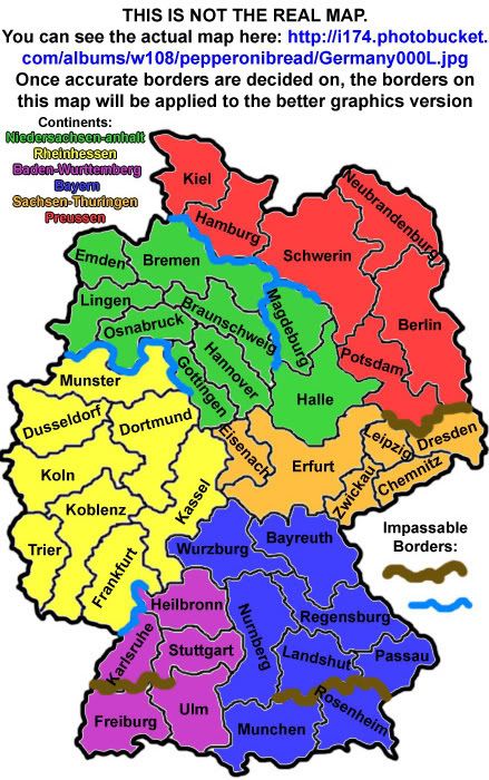
as a german i feel it is my duty to respond to this :P

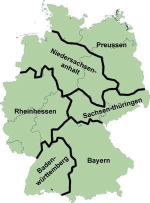
the map as it is is nice, no question. however, the bundesländer (states) are... well... not quite correct. you might wan to think of broader names for most of them. also all territs are named after cities on this map... why not go for the regions they actually represent? mainz for example could be changed to rheinhessen. and my last complaint is that most territories have the german name... and then a few random ones still have the english one. why? here are the translations:

Nuremburg: Nürnberg
Munich: München
Cologne: Köln
Prussia: Preussen
Dusseldorf: Düsseldorf

and Hannover is missing an N i believe (not 100% sure :P)

also, since it says Niederlande, Belgien and Frankreich, you might want to change the bits that say Germany to Deutschland... East would then be Ost and West stays West.

PostPosted: Mon Mar 24, 2008 11:28 am
by Wisse
daydream wrote:also, since it says Niederlande, Belgien and Frankreich, you might want to change the bits that say Germany to Deutschland... East would then be Ost and West stays West.


daydream, is "Niederlande" correct spelled? i thought it should be "Die Niederlanden" ?

PostPosted: Mon Mar 24, 2008 11:36 am
by Silvanus
Hello everyone!

pepperonibread wrote:I'm going to be going with a current map, as I think that's what the original author was going for.


That's the core of the problem. The geography of the current map is already weird and simply terribly wrong as MeDeFe said above. I don't know what the intention of the creator of the current map was, but he just put together some areas. He doesn't seem to know much about the different regions, that's why all the Germans say: whoa, you can't do that! (putting Düsseldorf into Hessen is something like to place New York somewhere in the countryside of west virginia)

Since it's a revamp, I'm not allowed to actually change how many territories the continents have or how they border other continents (no gameplay changes).


Hmm, so it's not possible to fix the chaos. I don't see a possibility to get a reasonable map based on the current one. Too much areas are cut by the borders and others are united wich don't belong to each other.
Maybe it would be the best to create a new map.

A compromise might be if you drop the unlucky names of the regions completely and use terms like "West" or "Southeast" in the USA map.

I can't believe I've forgotten my umlauts! These will all be fixed in the revision.


hehe, thanks

PostPosted: Mon Mar 24, 2008 12:40 pm
by cairnswk
my two bobs worth...since my great grandfather came from Elmshorn...i'd definitely like to see all names in German

PostPosted: Mon Mar 24, 2008 1:46 pm
by Silvanus
Wisse wrote:daydream, is "Niederlande" correct spelled? i thought it should be "Die Niederlanden" ?


Niederlande is perfect. Though the full name of this country is "Die Niederlande" on every map it's written short "Niederlande". This might be better on a map because it takes less space and is commonly used on maps, so "Niederlande" is ok here.

PostPosted: Tue Mar 25, 2008 5:54 am
by pepperonibread
Silvanus wrote:
pepperonibread wrote:Since it's a revamp, I'm not allowed to actually change how many territories the continents have or how they border other continents (no gameplay changes).


Hmm, so it's not possible to fix the chaos. I don't see a possibility to get a reasonable map based on the current one. Too much areas are cut by the borders and others are united wich don't belong to each other.
Maybe it would be the best to create a new map.

A compromise might be if you drop the unlucky names of the regions completely and use terms like "West" or "Southeast" in the USA map.


It looks like the bolded is what I'll be doing. Except for Bavaria. If I'm correct, that is an accurate German state.
So, more than anything, it seems like this is going to be a mainly graphical update.
Sorry for the late response :)

PostPosted: Tue Mar 25, 2008 8:35 am
by gimil
Since this is a revamp:

ImageImage

Pep you still have a few things missing thou. For example the page number of the latest update in the title and the information required in the first post :)

Information Requirements on the first post of a maps thread
1. The number of territories currently on the map.
2. The number of continents. (If this makes sense for your map)
3. Descriptions of any unique features or areas.

PostPosted: Tue Mar 25, 2008 9:10 am
by JerryB
mistake:

it should be Bamberg not Bamburg

PostPosted: Tue Mar 25, 2008 10:12 am
by Silvanus
pepperonibread wrote:
A compromise might be if you drop the unlucky names of the regions completely and use terms like "West" or "Southeast" in the USA map.

It looks like the bolded is what I'll be doing. Except for Bavaria. If I'm correct, that is an accurate German state.
So, more than anything, it seems like this is going to be a mainly graphical update.
Sorry for the late response :)


ok, much better like this :)
two things remain:
- we have to find another name for the yellow territory whis is named "Würzburg" right now, because Würzburg is a city in bavaria.
- and also: the German name is Bayern, not Bavaria.

cheers,
Slvanus

PostPosted: Tue Mar 25, 2008 4:09 pm
by pepperonibread
gimil wrote:Pep you still have a few things missing thou...

Thanks gimil. Fixed it.

JerryB wrote:mistake:
it should be Bamberg not Bamburg

Good catch :) It'll be in the next update.

Silvanus wrote:ok, much better like this
two things remain:
- we have to find another name for the yellow territory whis is named "Würzburg" right now, because Würzburg is a city in bavaria.
- and also: the German name is Bayern, not Bavaria.

cheers,
Silvanus

Thanks, this stuff will be fixed as well.

PostPosted: Tue Mar 25, 2008 10:43 pm
by oaktown
my least favorite aspect of this revamp is seeing the words tilted in any which way that they will fit. Can I suggest making the overall image size bigger, and zooming in a bit more on the playable area? You've got a lot of pixels to play with.

PostPosted: Wed Mar 26, 2008 6:45 am
by pepperonibread
oaktown wrote:my least favorite aspect of this revamp is seeing the words tilted in any which way that they will fit. Can I suggest making the overall image size bigger, and zooming in a bit more on the playable area? You've got a lot of pixels to play with.


Alright... I'll see what I can do when I adjust the width.

PostPosted: Wed Mar 26, 2008 6:48 am
by Seulessliathan
i totally agree with Silvanus ..... please change the "continents"

Re: [Official] Germany REVAMP - Images pg. 1

PostPosted: Thu Mar 27, 2008 9:09 am
by iancanton
this map is looking nice. i like the colours, with the emblems incorporated into the continent backgrounds.

Silvanus wrote:two things remain:
- we have to find another name for the yellow territory whis is named "Würzburg" right now, because Würzburg is a city in bavaria.
- and also: the German name is Bayern, not Bavaria.


we can align the continents completely with the länder boundaries by renaming some more territories. this lets us avoid using artificial directional names for the continents.

rename hanover as braunschweig (west germany continent becomes niedersachsen or maybe niedersachsen-anhalt - does this last name make sense to our german players?).
make kassel bigger and braunschweig smaller, then rename kassel as hannover.
rename würzburg as kassel (hessen continent becomes rheinhessen - this, suggested by daydream, is a well-known wine-producing region).
rheinland continent becomes baden-württemberg.
rename bamburg as würzburg (bavaria continent becomes bayern).
rename erfurt as jena.
make kassel (the old würzburg) bigger and fulda smaller, then rename fulda as erfurt (east germany continent becomes sachsen-thüringen).
rename prussia as preussen (suggested by daydream), unless we can think of a better name for this continent.

after renaming as above, will borders for unchanged gameplay be maintained if we use the correct political boundaries for the six continents (niedersachsen-anhalt, rheinhessen, baden-württemberg, bayern, sachsen-thüringen and preussen), based on the map below? i know that we can't use the actual political boundaries for each individual territory.

Silvanus wrote:http://www.acu.edu/academics/cas/fl/german/bundeslaender/bundeslaender.htm


can u erase the part of the river that forms the border between dresden and both berlin and potsdam and replace it with mountains, since the river doesn't go that way (see below)?

add the oder river along the eastern edges of neubrandenburg and most of berlin, then veer it south-east into poland to join up with the existing river. add the neisse river along the eastern edges of dresden and berlin to flow into the oder river. below is a link to the preussens gloria website, which has a map of these two rivers, that together form the border between germany and poland.

http://www.nccg.org/preussen/preussen8.html

ian. :)

Re: [Official] Germany REVAMP - Images pg. 1

PostPosted: Thu Mar 27, 2008 10:10 am
by guinniboy
i like the revamp most of the time i dont play this map because it lacks color, it somehow seems more interesting!

Re: [Official] Germany REVAMP - Images pg. 1

PostPosted: Thu Mar 27, 2008 3:43 pm
by pepperonibread
iancanton wrote:we can align the continents completely with the länder boundaries by renaming some more territories. this lets us avoid using artificial directional names for the continents.

rename hanover as braunschweig (west germany continent becomes niedersachsen or maybe niedersachsen-anhalt - does this last name make sense to our german players?).
make kassel bigger and braunschweig smaller, then rename kassel as hannover.
rename würzburg as kassel (hessen continent becomes rheinhessen - this, suggested by daydream, is a well-known wine-producing region).
rheinland continent becomes baden-württemberg.
rename bamburg as würzburg (bavaria continent becomes bayern).
rename erfurt as jena.
make kassel (the old würzburg) bigger and fulda smaller, then rename fulda as erfurt (east germany continent becomes sachsen-thüringen).
rename prussia as preussen (suggested by daydream), unless we can think of a better name for this continent.

after renaming as above, will borders for unchanged gameplay be maintained if we use the correct political boundaries for the six continents (niedersachsen-anhalt, rheinhessen, baden-württemberg, bayern, sachsen-thüringen and preussen), based on the map below? i know that we can't use the actual political boundaries for each individual territory.

Silvanus wrote:http://www.acu.edu/academics/cas/fl/german/bundeslaender/bundeslaender.htm


ian. :)


Okay. So, you're suggesting continents like this, right: Quick Draft
Just wanted to clarify.
Like you said, the problem isn't going to be the continent (state) borders, but the individual territories. So I'll get a draft of territories within these new state boundaries hopefully soon, and allow everybody some time to give suggestions on it. I should be able to use the territory names you suggested, but I'll see how it pans out.
Thanks for the suggestions :) Everything else you posted I agreed with.

Re: [Official] Germany REVAMP - Images pg. 1

PostPosted: Thu Mar 27, 2008 4:24 pm
by iancanton
pepperonibread wrote:Okay. So, you're suggesting continents like this, right: Quick Draft


that's exactly right!

ian. :)

Re: [Official] Germany REVAMP - Images pg. 1

PostPosted: Sat Mar 29, 2008 4:09 am
by Lone.prophet
i think that holland or niederlande should be a bit more its real shape

Re: [Official] Germany REVAMP - Images pg. 1

PostPosted: Sat Mar 29, 2008 5:00 am
by Skittles!
Lone.prophet wrote:i think that holland or niederlande should be a bit more its real shape

I think that this is a Germany Revamp, not the shape of Netherlands topic.

Looking good Pep! Keep it going. Way better than the original, in my thoughts.

Re: [Official] Germany REVAMP - Images pg. 1

PostPosted: Sat Mar 29, 2008 8:05 am
by mibi
this map looks great and is a real improvement but I would like to see the black/red/gold reintroduced. The current Germany map sucks in terms of graphics but with such bold and present colors it was undeniably German. Aside from the type, there isn't a whole lot German about it.

Re: [Official] Germany REVAMP - Images pg. 1

PostPosted: Sat Mar 29, 2008 11:02 am
by pepperonibread
mibi wrote:this map looks great and is a real improvement but I would like to see the black/red/gold reintroduced. The current Germany map sucks in terms of graphics but with such bold and present colors it was undeniably German. Aside from the type, there isn't a whole lot German about it.


Alright, sounds good. Because of the width change and the major border changes, basically this whole map is going to be redone. So I'll have a lot of time to add in some more german flavor.

Re: [Official] Germany REVAMP - Images pg. 1

PostPosted: Sat Mar 29, 2008 6:43 pm
by pepperonibread
Alright guys, after doing some more research, here's the draft I came up with:

Image

Like it was suggested, the "continents" now all align with the state borders of Germany. But because the borders were changed so much (the shape of the borders only, no gameplay changes), I needed to change the names of some of the territories. This is what I'd like comments on (from Germans, if possible). I need as accurate names as possible. Once all this stuff is ironed out, I'll begin working on applying these changes to the "graphically enhanced" version.
Also, no umlauts yet, so don't mind that.

PostPosted: Sat Mar 29, 2008 7:08 pm
by Unit_2
With a revamp you can only make differnt graphic changes not gameplay.

Re: [Official] Germany REVAMP - Draft of New Borders Pg. 4

PostPosted: Sat Mar 29, 2008 7:13 pm
by Kaplowitz
It it plays the same way then its fine.

Re:

PostPosted: Sat Mar 29, 2008 7:21 pm
by pepperonibread
Unit_2 wrote:With a revamp you can only make differnt graphic changes not gameplay.


Kaplowitz wrote:It it plays the same way then its fine.


Sorry guys, guess I didn't explain well enough. The shape of the borders has changed, but the gameplay is all the same. Just like my first draft and the original map. I'll edit my previous post.