Re: [Official] Germany REVAMP - Draft of New Borders Pg. 4
okay, now i understand, 
Conquer Club, a free online multiplayer variation of a popular world domination board game.
https://www.conquerclub.com/forum/
https://www.conquerclub.com/forum/viewtopic.php?f=358&t=47140
Arachnophobia wrote:some suggestions:
The mountains in bavaria - replace them with river and try to put it a lil more north. That would be awesome for realism (and wouldnt change gameplay).
Visually extend Braunschweig til the river and shorten Bremen.
Rename Neubrandenburg to Vorpommern. Better name imo. Rename Schwerin to Mecklemburg
some things that would affect gameplay:
- add Magdeburg and Halle to prussia continent and Kiel and Hamburg to Niedersachsen-Anhalt. Add a bridge between Hamburg and Bremen. Rename Niedersachen-Anhalt to North Germany and Prussia to East Germany. Maybe you can put Hamburg ON the river and kill a bit of Bremen for that.
- Shorten Schwerin in the south. Extend Potsdam to were Schwerin was. Revamp the whole Potsdam Berlin to something like this: Berlin gets an autodeploy for 1 army and is surrounded by Brandenburg (old Potsdam) or by Potsdam in West and a new territory, Cottbus in east.
- kill the northeastern part of Erfurt for more territory of Leipzig (Halle-Leipzig are REALLY close to eachother in reality and that should be represented).
- to make East Germany less easily defended, shorten the river left of magdeburg to create a new frontier
Thats it for now, south and western germany come next when I got more time :p
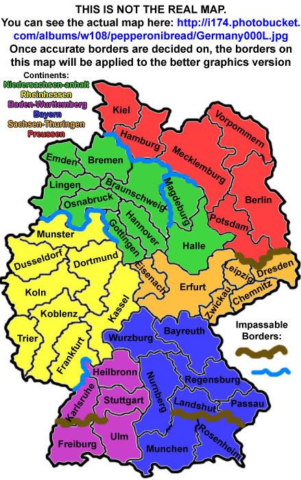
pepperonibread wrote:Like it was suggested, the "continents" now all align with the state borders of Germany. But because the borders were changed so much (the shape of the borders only, no gameplay changes), I needed to change the names of some of the territories. This is what I'd like comments on (from Germans, if possible). I need as accurate names as possible. Once all this stuff is ironed out, I'll begin working on applying these changes to the "graphically enhanced" version.
Also, no umlauts yet, so don't mind that.
Splash_x wrote:I don't know if its just me.. but the font for the title and the authors... are a bit werid... maybe put them elsewhere? or make it seem like its not going from BIGGER tooooooooooooo smaller

Ogrecrusher wrote:3 comments to add to the above map.
Missing bridges:
Mechlemburg <-> Halle
Köln <-> Koblenz
Missing Connection:
Passau <-> Landshut
As far as I can see, these are the only issues.


Arachnophobia wrote:After change
I corrected the continents "Niedersachsen-Anhalt" and "Preussen" so that they resemble more of a historic and cultural unity. Niedersachsen-Anhalt -> Norddeutschland and Preussen could stay that name. As you can look up with the numbering of the green territories, there are no gameplay changes. I had to introduce a new river though, the "Weser", which should have been included anyways (like 4th longest river in germany...). I also added a new territory "Rügen", which was not previously on the map. Its germany's biggest island and only a lil offshore from the rostock territory. Ofc the territories are rather scetchy and unnamed yet, they definately need to be reshaped a bit better and get some good names, but I dont want to do that with this scetch yet. Need opinions first ^^
pepperonibread wrote:The one thing I might be hesistant to do is make that river through Rheinhessen. Normally on maps, rivers and mountains and other impassables are used to create better gameplay (and in this case preserve it). As CC maps are rarely perfectly accurate, I think the middle section with bridges could be cut out without to much trouble. I just have a feeling that with bridges spanning across every section of the river, it will only clutter the map and leave less room for names/army numbers. Same could go for the northeastern river (will mountains not work there?), but I'll need more comments on that.
Also, like you said, I'll need to get more comments on the "Norddeutschland" name and shape change before I can go ahead.
Besides that, looks great! Sorry for the late response. Thanks for taking an interest in the map
EDIT: I see you also mentioned a swamp. That could work, depending on how good I am at drawing swamps
iancanton wrote:below is a link to the preussens gloria website, which has a map of these two rivers, that together form the border between germany and poland.
http://www.nccg.org/preussen/preussen8.html
ian.
iancanton wrote:between dresden and berlin, a swamp is much better than a river, especially as there is a well-known river system running all the way along the eastern border of germany from the czech republic to the baltic sea, the famous oder-neisse line that stalin imposed as the border with poland. the neisse does not join up with any river in sachsen. although gameplay doesn't demand it, perhaps the oder-neisse line can be shown as a visual marker.iancanton wrote:below is a link to the preussens gloria website, which has a map of these two rivers, that together form the border between germany and poland.
http://www.nccg.org/preussen/preussen8.html
ian.
there are some low hills between dresden and berlin so, in the absence of a swamp symbol, a brown impassable is more appropriate than a blue one for the time being.
the new schwerin boundaries don't work, since berlin needs to border three territories.
münchen is now in a better place than before. ulm is in baden-württemberg, not bayern (the thick blue line on the map below shows the boundary), so augsburg is a more suitable name than ulm for the territory in south-west bayern, with tübingen perhaps being replaced by ulm (i think ulm is more famous, but is tübingen more important? i'm unsure about this).
http://www.welt-atlas.de/map_of_schwaebische_alb_1-667
ian.
iancanton wrote:there are some low hills between dresden and berlin so, in the absence of a swamp symbol, a brown impassable is more appropriate than a blue one for the time being.
the new schwerin boundaries don't work, since berlin needs to border three territories.
münchen is now in a better place than before. ulm is in baden-württemberg, not bayern (the thick blue line on the map below shows the boundary), so augsburg is a more suitable name than ulm for the territory in south-west bayern, with tübingen perhaps being replaced by ulm (i think ulm is more famous, but is tübingen more important? i'm unsure about this).
Looks good. Any comments on Niedersachsen-Anhalt (now "Norddeutschland")? The "continents" would know longer align with the german state borders, though it looks like it could be more accurate than before.
Arachnophobia wrote:Looks good. Any comments on Niedersachsen-Anhalt (now "Norddeutschland")? The "continents" would know longer align with the german state borders, though it looks like it could be more accurate than before.
Actually, they still do, but now in a better cultural unity