Re: [Official] Germany REVAMP - DRAFT of New Borders Pg. 5
Yes! thank you, I hate the old graphics
Conquer Club, a free online multiplayer variation of a popular world domination board game.
https://www.conquerclub.com/forum/
https://www.conquerclub.com/forum/viewtopic.php?f=358&t=47140
Arachnophobia wrote:After change
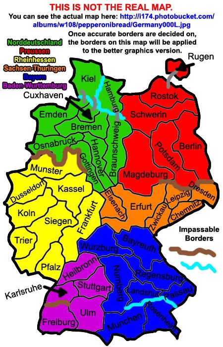
I corrected the continents "Niedersachsen-Anhalt" and "Preussen" so that they resemble more of a historic and cultural unity. Niedersachsen-Anhalt -> Norddeutschland and Preussen could stay that name. As you can look up with the numbering of the green territories, there are no gameplay changes. I had to introduce a new river though, the "Weser", which should have been included anyways (like 4th longest river in germany...). I also added a new territory "Rügen", which was not previously on the map. Its germany's biggest island and only a lil offshore from the rostock territory. Ofc the territories are rather scetchy and unnamed yet, they definately need to be reshaped a bit better and get some good names, but I dont want to do that with this scetch yet. Need opinions first ^^
pepperonibread wrote:The one thing I might be hesistant to do is make that river through Rheinhessen. Normally on maps, rivers and mountains and other impassables are used to create better gameplay (and in this case preserve it). As CC maps are rarely perfectly accurate, I think the middle section with bridges could be cut out without to much trouble. I just have a feeling that with bridges spanning across every section of the river, it will only clutter the map and leave less room for names/army numbers. Same could go for the northeastern river (will mountains not work there?), but I'll need more comments on that.
Also, like you said, I'll need to get more comments on the "Norddeutschland" name and shape change before I can go ahead.
Besides that, looks great! Sorry for the late response. Thanks for taking an interest in the map
EDIT: I see you also mentioned a swamp. That could work, depending on how good I am at drawing swamps
iancanton wrote:below is a link to the preussens gloria website, which has a map of these two rivers, that together form the border between germany and poland.
http://www.nccg.org/preussen/preussen8.html
ian.
iancanton wrote:between dresden and berlin, a swamp is much better than a river, especially as there is a well-known river system running all the way along the eastern border of germany from the czech republic to the baltic sea, the famous oder-neisse line that stalin imposed as the border with poland. the neisse does not join up with any river in sachsen. although gameplay doesn't demand it, perhaps the oder-neisse line can be shown as a visual marker.iancanton wrote:below is a link to the preussens gloria website, which has a map of these two rivers, that together form the border between germany and poland.
http://www.nccg.org/preussen/preussen8.html
ian.
there are some low hills between dresden and berlin so, in the absence of a swamp symbol, a brown impassable is more appropriate than a blue one for the time being.
the new schwerin boundaries don't work, since berlin needs to border three territories.
münchen is now in a better place than before. ulm is in baden-württemberg, not bayern (the thick blue line on the map below shows the boundary), so augsburg is a more suitable name than ulm for the territory in south-west bayern, with tübingen perhaps being replaced by ulm (i think ulm is more famous, but is tübingen more important? i'm unsure about this).
http://www.welt-atlas.de/map_of_schwaebische_alb_1-667
ian.
iancanton wrote:there are some low hills between dresden and berlin so, in the absence of a swamp symbol, a brown impassable is more appropriate than a blue one for the time being.
the new schwerin boundaries don't work, since berlin needs to border three territories.
münchen is now in a better place than before. ulm is in baden-württemberg, not bayern (the thick blue line on the map below shows the boundary), so augsburg is a more suitable name than ulm for the territory in south-west bayern, with tübingen perhaps being replaced by ulm (i think ulm is more famous, but is tübingen more important? i'm unsure about this).
Looks good. Any comments on Niedersachsen-Anhalt (now "Norddeutschland")? The "continents" would know longer align with the german state borders, though it looks like it could be more accurate than before.
Arachnophobia wrote:Looks good. Any comments on Niedersachsen-Anhalt (now "Norddeutschland")? The "continents" would know longer align with the german state borders, though it looks like it could be more accurate than before.
Actually, they still do, but now in a better cultural unity
Arachnophobia wrote:any updates on this one?
gimil wrote:Pep whats the latest mate?
true, but we're stuck with having an impassable there!Arachnophobia wrote:Not really, 200m high hills are a really weak argument for a boundaryiancanton wrote:there are some low hills between dresden and berlin so, in the absence of a swamp symbol, a brown impassable is more appropriate than a blue one for the time being.
agreed. the lack of territory numbers in preussen confused me a bit. imaginatively done!Arachnophobia wrote:I dont quite understand that one. I'll explain what happened:iancanton wrote:the new schwerin boundaries don't work, since berlin needs to border three territories.
The new "Rügen" territory is the former Kiel. The Rostock territory is the former Hamburg. The Berlin territory is the former Rostock, Potsdam was the former Berlin and the former Potsdam is the new territory combined from former Halle and Magdeburg. If you compare, no border changes were made
pepperonibread wrote:Like it was suggested, the "continents" now all align with the state borders of Germany. But because the borders were changed so much (the shape of the borders only, no gameplay changes), I needed to change the names of some of the territories. This is what I'd like comments on (from Germans, if possible). I need as accurate names as possible. Once all this stuff is ironed out, I'll begin working on applying these changes to the "graphically enhanced" version.
Also, no umlauts yet, so don't mind that.
Ruben Cassar wrote:Nice to see this map getting a revamp. It badly needed one.
1. The images of the coat of arms for every region is a nice idea but it just doesn't work. It makes the regions less clear.
2. The various angles used for the territory names give the map an untidy look. Can you make the territory names smaller and all horizontal? Personally I don't like the font used either.
3. The eagle background used in the legend makes it less legible. The Östereich name just showing underneath it makes it look disorderly as well. The map is already busy enough.
4. The map seems unnecessarily wide. There's a lot of unused space currently occupied by neighbouring states which could be eliminated.
5. I suggest sticking to German names like Bayern instead of Bavaria and München instead of Munich.
Keep up the good work guys. Looking forward to the next update.
pepperonibread wrote:Ruben Cassar wrote:Nice to see this map getting a revamp. It badly needed one.
1. The images of the coat of arms for every region is a nice idea but it just doesn't work. It makes the regions less clear.
2. The various angles used for the territory names give the map an untidy look. Can you make the territory names smaller and all horizontal? Personally I don't like the font used either.
3. The eagle background used in the legend makes it less legible. The Östereich name just showing underneath it makes it look disorderly as well. The map is already busy enough.
4. The map seems unnecessarily wide. There's a lot of unused space currently occupied by neighbouring states which could be eliminated.
5. I suggest sticking to German names like Bayern instead of Bavaria and München instead of Munich.
Keep up the good work guys. Looking forward to the next update.
1. I'll need more comments on this, as many posted about liking the coats of arms in previous pages (though many did the opposite). I'll tone them somewhat in the next update, but this may be similar to the debate about flags in the Great Lakes thread prior to quench; split about 50-50. In that case, I'll try to compromise as best I can.
2. I personally like the angles, but one thing that maybe could help is to curve some of the names slightly. I'll see what others think about this.
3. You can see Östereich through that?Anyway, the legend will definitely be moved and resized considerably when I rework the map; I'll keep this in mind when I do.
4. Agreed, this has been brought up by others as well, when I rework the high-graphics version I'll certainly be rearranging some things to better fit.
5. Fixed in the current draft, I'll be sure to have this in the final version.
Thanks
gimil wrote:When are the super cool, shit hot graphics coming back into action?
pepperonibread wrote:-River through Rheinhessen: I think I've fixed this by extending Heilbronn across the entire northern border of Baden Wurttemburg. I call this a fix because I think it clears up the map, without the river and bridges. As for the small part of this river that formed the northern border of Dusseldorf, I think simply extend the adjacent mountain range slightly won't be too bad for the map's accuracy.
pepperonibread wrote:-The territory Siegen: This city and the city of Kolbenz have virtually equal populations, so it's up to our German CCer's which should be used as the territory name (which one is more well known?)
pepperonibread wrote:-I took Arachnophobia's changes to the Norddeutschland continent, and changed a few things so fewer rivers are needed. Specifically, I added the Kiel Canal to allow for two territories above the now-shortened Elbe river. I then adjusted the other territories accordingly, so gameplay was not changed.
pepperonibread wrote:-To Arachnophobia specifically: What was the rationale for adding Coburg to the Bayern continent? From the research I've done, it seems like a smaller city than Landshut and the other territories. I kept these territories the same until this and the deal with Ulm is resolved.
pepperonibread wrote:-I'm not sure what the verdict was on the impassable between Preussen and Sachsen-Thuringen, so I kept that as a mountain/swamp for the time being.
[/quote][/quote]pepperonibread wrote:-Because I still dislike the tight territories and rivers with many bridges it the continent Norddeutschland, (...)
Admittedly, the second one has not existed for a long time, but could this still work as a sort of cultural unity? Any German natives who could comment on this part would be great.
pepperonibread wrote:-River through Rheinhessen: I think I've fixed this by extending Heilbronn across the entire northern border of Baden Wurttemburg. I call this a fix because I think it clears up the map, without the river and bridges. As for the small part of this river that formed the northern border of Dusseldorf, I think simply extend the adjacent mountain range slightly won't be too bad for the map's accuracy.
Its ok that way, although I dont like the look of the Siegen territory :p
pepperonibread wrote:-The territory Siegen: This city and the city of Kolbenz have virtually equal populations, so it's up to our German CCer's which should be used as the territory name (which one is more well known?)
Both are about the same level of reputation I would say, maybe someone from the region can decide this (im from berlin...)
pepperonibread wrote:-I took Arachnophobia's changes to the Norddeutschland continent, and changed a few things so fewer rivers are needed. Specifically, I added the Kiel Canal to allow for two territories above the now-shortened Elbe river. I then adjusted the other territories accordingly, so gameplay was not changed.
Euhg, that arrow country solution is awful :p (and the name of it is even more awful as Cuxhafen is a city at the ocean :p )
What we could do is:
Hamburg -> Lübeck
Cuxhaven -> Hamburg
That way its more realistic :p
pepperonibread wrote:-To Arachnophobia specifically: What was the rationale for adding Coburg to the Bayern continent? From the research I've done, it seems like a smaller city than Landshut and the other territories. I kept these territories the same until this and the deal with Ulm is resolved.
Landshut is south of the river we added (quite a lot at that), so having it north of it wasnt realistic. Thatswhy I moved the territories around a bit to find a viable solution :p
Also the Regensburg territory needs to be at the river, as the city of regensburg lies at the river...).
pepperonibread wrote:-I'm not sure what the verdict was on the impassable between Preussen and Sachsen-Thuringen, so I kept that as a mountain/swamp for the time being.
Swamp sounds fine
pepperonibread wrote:-Because I still dislike the tight territories and rivers with many bridges it the continent Norddeutschland, (...)
Admittedly, the second one has not existed for a long time, but could this still work as a sort of cultural unity? Any German natives who could comment on this part would be great.
Most of the current names for the states are somewhat arbitrary, but the saxony-anhalt territory was a former part of the german democratic republic, while lower saxony was part of the federal german republic. As I understand it, we're making a map of modern germany so the new continents represent the cultural and historical bounds more precisely...
One corrections:
Rostok -> Rostock
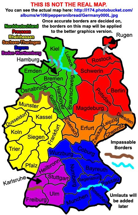
pepperonibread wrote:Like it was suggested, the "continents" now all align with the state borders of Germany. But because the borders were changed so much (the shape of the borders only, no gameplay changes), I needed to change the names of some of the territories. This is what I'd like comments on (from Germans, if possible). I need as accurate names as possible. Once all this stuff is ironed out, I'll begin working on applying these changes to the "graphically enhanced" version.
Also, no umlauts yet, so don't mind that.
Lone.prophet wrote:i think the flags of the regions look kinda a shitty i think they dont really look nice in there
pepperonibread wrote:The territory Siegen: This city and the city of Kolbenz have virtually equal populations, so it's up to our German CCer's which should be used as the territory name (which one is more well known?)
iancanton wrote:pepperonibread wrote:The territory Siegen: This city and the city of Kolbenz have virtually equal populations, so it's up to our German CCer's which should be used as the territory name (which one is more well known?)
although i'm not german, my cousin lives in koblenz. very nice city it is too. my vote goes firmly to koblenz. according to wikipedia, siegen used to be part of koblenz region, so koblenz has history on its side. koblenz is a third-level administrative division (under country and state), while siegen is fourth-level (beneath country, state and region).
Siegen was assigned to the Siegen district, first in the Koblenz region, and as of 1817 in the Arnsberg region within the Prussian Province of Westphalia.
http://en.wikipedia.org/wiki/Siegen
if u're looking for a city that is between frankfurt and münster, then i think dortmund fits better than kassel. it is also a much bigger city and more famous to industrialists and football (soccer) fans. i don't object strongly to kassel, but simply favour dortmund slightly.
pfalz looks out of place: all other territories are cities, but pfalz (palatinate) is not. one good name for that territory is mainz, the capital city of rheinland-pfalz state. another, especially for football fans, is kaiserslautern.
to make the long, narrow territories in norddeutschland less of a problem, would anyone mind if germany was stretched horizontally into a squarer shape (like a wide-screen monitor does to photographs)? is this easy to do? would the result look good?
i'm happy with the old arrangement of territories if the new one makes it difficult to position names and army circles in norddeutschland.
keep up the good work!
ian.
