Page 2 of 28

Re: Hemisphere: the world at war

PostPosted: Sun Apr 20, 2008 1:53 pm
by greenoaks
this doesn't grab me. i feel ripped off playing for half the world.

i can understand playing for a city, country, continent or the entire world.
i can understand playing a region that has been involved a war.

but right now this just seems to fall between those two.

Re: Hemisphere: the world at war

PostPosted: Sun Apr 20, 2008 1:55 pm
by InkL0sed
oaktown wrote:
TaCktiX wrote:I say keep it geographic, but use some older political boundaries than present day. I'm liking the look you've got right now, and if you want to age the boundaries to WWI era, more power to you, just don't make WWI proper the focus.

right... it doesn't haveto be WWI per se, but i like having the 1914 theme to push the graphics.


Right... so don't mention WWI. Call it "The Old World in 1913" or something like that.

Re: Hemisphere: the world at war

PostPosted: Sun Apr 20, 2008 3:54 pm
by edbeard
I know it's an early draft, but you've got some darn small countries on there. What'll happen with the small map?

Are you splitting up these areas more for bonuses? Almost every one has ten territories. Maybe it's not a bad thing. Just a different style for the map.


I think you've chosen the colours quite well btw.

Re: Hemisphere: the world at war

PostPosted: Sun Apr 20, 2008 4:24 pm
by CatfishJohnson
Well man, it called a hemisphere for a reason, its half, i mean why would u be ripped off, it allows u to go into more detail on that half of the earth, then u can do the other half with NA and SA on it fo sho

Re: Hemisphere: the world at war

PostPosted: Sun Apr 20, 2008 4:44 pm
by oaktown
edbeard wrote:I know it's an early draft, but you've got some darn small countries on there. What'll happen with the small map?

Are you splitting up these areas more for bonuses? Almost every one has ten territories. Maybe it's not a bad thing. Just a different style for the map.

Everything is up for discussion... I just like the overall footprint of the Eastern Hemisphere as a map. We could do big regions, more small regions, or sub-regions within continents like World 2.1. I'd like to hear what you all think works.

Going back a bit in time offers two things to the project:
1. a bit more flexibility in terms of how we draw borders. A contemporary map runs into all sorts of problems about what we call Israel, including Kosovo, etc.
2. visual direction.

As for exactly how far back we go, that is also up for discussion. The 1910s present a particularly violent period for the Eastern Hemisphere, with fighting in Europe, the Middle East, Africa, India, the Pacific Islands, and Colonial regions of China. New Zealand and Australia were involved in the great war, ancient empires in Asia and Europe collapsed, new nations were forged, revolutions were begun.

Re: Hemisphere: the world at war

PostPosted: Sun Apr 20, 2008 4:48 pm
by Kaplowitz
I think some of the countries are too big, while others are too small. I think you should do only a geographical map with geographical borders. Maybe for gfx you could try to recreate a satellite image. That would look really cool (and IMO cooler than the actual satellite image!)

Re: Hemisphere: the world at war (w. new poll)

PostPosted: Sun Apr 20, 2008 11:01 pm
by Incandenza
I don't think the eastern hemisphere is a bad idea, but I voted for the L.A. map, for obvious reasons. 8-)

Re: Hemisphere: the world at war (w. new poll)

PostPosted: Mon Apr 21, 2008 8:28 am
by ZeakCytho
I love the idea of an eastern hemisphere map, but not the current graphics or the 1914 theme. The satelite idea suggested by Kaplowitz sounds very promising.

Re: Hemisphere: the world at war (w. new poll)

PostPosted: Mon Apr 28, 2008 12:42 am
by oaktown
Click image to enlarge.
image

Still haven't had the time I'd like to attack this map, but I thought I'd at least post what I have before I forget about it.

I hear the comments about going satellite image, but that's not really something I get excited about... I prefer the historical aspect of maps, as some of you may have gathered from my past work. Anyway, I'm going to try to lay out an early 19th century eastern hemisphere with territories and regions, and then we can worry about what it will look like.

Re: Eastern Hemisphere

PostPosted: Mon Apr 28, 2008 10:07 am
by t-o-m
like it...
the russian terit looks impossible to hold - maybe instead of having sub-conts have a bonus for collecting things inside it -(like the stars on WWII map)??
and there is a lil bit of orange on thailand/burma-that region anyway - its probably just a mistake
but over all the conts really do look hard to hold - but youre going to put immpassables on it right?
also is it too big or ok?

Re: Eastern Hemisphere

PostPosted: Mon Apr 28, 2008 2:39 pm
by ZeakCytho
I think 1910 is a much better year than 1914, simply because you can put Germany, France, and GB in the same continent (Europe) now.

You seem to be using different font/styles for different territories? Turkestan, Siberia, Taymyr, and other territories in that region don't have a glow on them, but others in Russia ( Moscow, Ukraine, Finland) do. Personally, I like the glow better.

I think you need to change the background to something slightly more water-like.

The territory of Afghanistan isn't where Afghanistan is at all, or was at the time. Could that be named something else?

Are Korea and Japan part of the SE Asia bonus? You might want to consider making them a continent of their own. I'm not a big fan of split continents.

So far, so good, though. :)

Re: Eastern Hemisphere

PostPosted: Mon Apr 28, 2008 2:51 pm
by t-o-m
is kinda all over the place, but as you said youve not had the time to do it,
t-o-m wrote:and there is a lil bit of orange on thailand/burma-that region anyway - its probably just a mistake

also on persia and the ottoman empire (but thats red)
and some red on the right hand side of persia
and soem brown on S. Afirca (the 1st yellow terit at the top left of that cont)
and blue in russia
lack of red colour in amur
green in Tumerikstan
the territ boarders arnt complete
basically you need to just spend some time on this when youve got some ;)

Re: Eastern Hemisphere

PostPosted: Mon Apr 28, 2008 9:52 pm
by oaktown
I'm not even worried about the fonts, color over-lapping, etc. The map isn't at the point where I'm at all worried about how it looks.

Gameplay wise everything region is going to a bitch to hold as it stands right now. I'll throw in some impassables at some point - alps, himalayas, etc. Perhaps auto-deploys on major cities or key natural resources? Partial bonuses for holding part of a region?

Re: Eastern Hemisphere

PostPosted: Tue Apr 29, 2008 12:01 pm
by t-o-m
oaktown wrote:I'm not even worried about the fonts, color over-lapping, etc. The map isn't at the point where I'm at all worried about how it looks.

Gameplay wise everything region is going to a bitch to hold as it stands right now. I'll throw in some impassables at some point - alps, himalayas, etc. Perhaps auto-deploys on major cities or key natural resources? Partial bonuses for holding part of a region?

yea sub-conts and things (but make the bonuses small so it makes the people go for the whole cont),
you dont want it to be like 2.1 but just chopped off at the side

Re: Eastern Hemisphere

PostPosted: Tue Apr 29, 2008 2:55 pm
by sam_levi_11
looks great! i like the idea of it, but i bet becuase america isnt on here some people wont play it :roll: :lol:

Re: Eastern Hemisphere

PostPosted: Tue Apr 29, 2008 8:13 pm
by Ruben Cassar
You've got the Russian Empire in there and the Chinese Empire (which I am not sure existed at that time) but what happened to the French and British Empires? Most of Africa as well as parts of Asia like India and even Burma were part of those empires. Most of the Balkans region was part of the Austro-Hungarian Empire as far as I know, which is also the origin of World War I.

Note as well the spelling mistakes in these regions: Sevastopol and Afghanistan.

Re: Eastern Hemisphere

PostPosted: Tue Apr 29, 2008 8:21 pm
by ZeakCytho
Ruben Cassar wrote:You've got the Russian Empire in there and the Chinese Empire (which I am not sure existed at that time) but what happened to the French and British Empires? Most of Africa as well as parts of Asia like India and even Burma were part of those empires. Most of the Balkans region was part of the Austro-Hungarian Empire as far as I know, which is also the origin of World War I.

Note as well the spelling mistakes in these regions: Sevastopol and Afghanistan.


A fair amount of the Balkans was ruled by the Ottoman Empire until the First Balkan War (1912-13).

I think having the colonial empires present would create an interesting map, however, I strongly advise against having the bonuses done on political divisions. Since many colonies were non-contiguous, this would splinter so many continents that it would be an absolute mess to sort things out.

I'd much prefer to see a map not set in a particular time, or, at least one that has geographic boundaries for bonuses instead of political ones.

On an unrelated note, I don't like the idea of having auto-deploys on major cities or of having natural resources. I could live with partial bonuses for regions of continents, but would prefer purely classic gameplay.

Re: Eastern Hemisphere

PostPosted: Thu May 01, 2008 11:27 am
by AndyDufresne
I like the look of this map...look forward to seeing it progress.


--Andy

Re: Eastern Hemisphere

PostPosted: Fri May 02, 2008 6:49 pm
by Emperor_Metalman
Some of the larger countries should be split up

Re: Eastern Hemisphere

PostPosted: Wed May 07, 2008 6:13 am
by jasnostj
Technically, the Eastern Hemisphere starts east of Greenwich, cutting of large chunks of Europe (Spain!) and Africa. But the term sounds odd to me: I have never heard a European (I happen to be one) use it to refer to the place they live, as opposed to Americans frequently describing their part of the world as the Western Hemisphere. We generally consider ourselves on the western side too.

Besides, I think this map is pretty useless, like the New Europe map. I think cartographers of your talent better occupy themselves in making more interesting detail maps. Lots has been suggested in the Map Ideas forum, also by me.

Re: Eastern Hemisphere

PostPosted: Wed May 07, 2008 11:05 am
by bryguy
I like the look, but it could use alot of work


1) The white territory lines bug me, maybe put them on overlay?
2) The thing that bugs me the most is the yellow lettering behind the white lines, i think u should either get rid of them or put them OVER the white lines and more transparent
3) Also, the territory lines look.... bad
4) The colors for africa/middle east bug me, but fit the areas
5) The colors for areas that i cant stand are the colors for

Europe, S.E. Asia, Chinese Empire, Oceania

hopefully more when this gets further along :)

p.s., i like the "A World on the Brink of War", its a nice touch

Re: Eastern Hemisphere

PostPosted: Wed May 07, 2008 9:43 pm
by TaCktiX
Major bone I've got with the map as you (incompletely, I know) posted it: the territory lines do not look convincing at all. On Fukien, for example, you've got this double arc ending in a single point. That looks contrived instead of accurate. In general, the lines are too perfectly straight for me to think "hey, cool, power influences in 1910!" Before you get too far along, could you make them more believable?

Re: Eastern Hemisphere

PostPosted: Wed May 07, 2008 10:41 pm
by rocky mountain
pardon my laziness to read the whole thread, but has anyone mentioned that turkestan is not a country? or was it in 1910... sry if i'm wrong, but i thought it was worth mentioning...

Re: Eastern Hemisphere

PostPosted: Thu May 08, 2008 3:08 pm
by pepperonibread
rocky mountain wrote:pardon my laziness to read the whole thread, but has anyone mentioned that turkestan is not a country? or was it in 1910... sry if i'm wrong, but i thought it was worth mentioning...


http://en.wikipedia.org/wiki/Turkestan

A region, not a country... though it could have been in 1910.

Re: Eastern Hemisphere

PostPosted: Sun Jun 01, 2008 2:37 am
by oaktown
Click image to enlarge.
image

No, this map isn't entirely dead... I just tend to get distracted.

What's new/where I would like feedback:
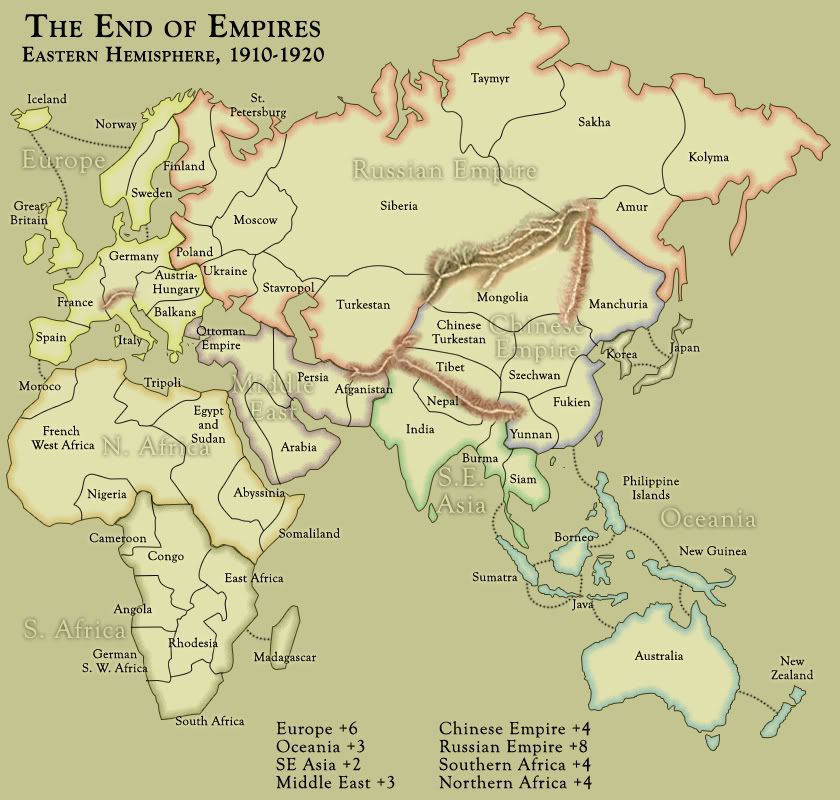
• I've totaled up the regions and territories and discovered that I have 61 territories... this isn't good, as it means four player games start with 15 terits each and 5 player games start with 12 each, meaning whoever goes first gets more armies in their first drop than somebody who goes later. The remedy will either be dropping two territories to get us under 60, or adding four to bring the map to 65. Suggestions??
• Plugged the regions into my excel spreadsheet and came up with the bonuses shown... they seem a bit low considering how hard everything will be to hold, but I always prefer to err low rather than high. Feedback appreciated.
• I made mountains, because it was important to determine which region borders would be protected, and I didn't want to do it half-ass. I kinda like these mountains, and hope that they reflect the look I'd like to achieve for the overall map. (I also made them because mountains always present a challenge!) Question: should the Caucasus range be made impassable? I don't know the region or how much they would have effected warfare in the early 20th century. For that matter, is there any other range or river that would be a barrier to 1910 technology? And I will not be adding the Great Wall of China, so don't even ask.
• Added some attack routes so we can get a handle on how this might play.

What I would NOT like feedback on yet:
• just about anything visual... colors, borders, fonts, etc. all have yet to be worked on. I'm still trying to think out whether or not this map will be playable before I knock myself out trying to make it pretty.

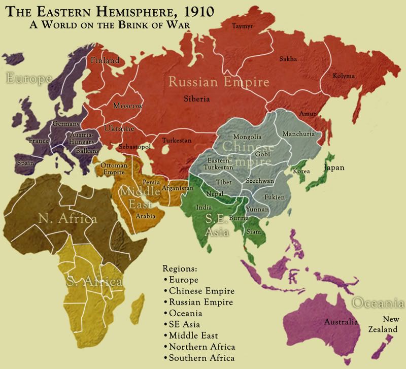
As for Turkestan, no it wasn't a country. Nor was anything else that is in the "Russian Empire" - they are all regions of the larger political body.