Re: Indian Empire (D, GP) page 11
Actually, it is Empress Victoria, the first ever empress of India. Although she did reign as Queen of the British Empire. I'm picky like that,  .
.
Conquer Club, a free online multiplayer variation of a popular world domination board game.
https://www.conquerclub.com/forum/
https://www.conquerclub.com/forum/viewtopic.php?f=358&t=58715

porkenbeans wrote:I agree with sam, I can NOT find anything to pick at.
You are in my opinion, CCs' best asset, when it comes to maps.
I like all of your maps, and this one looks to be one of your best.
You will always have a standing invitation to come work with us at "The Mapmakers Guild".
To anyone out there that is in to organizing tournaments, I would suggest an Oaktown turny, with all the oaktown maps.
WidowMakers wrote:Hey oak. How did you do the RR tracks?
cairnswk wrote:oaktown
if you're using PS3, there is railway line brush available at
http://www.adobe.com/cfusion/exchange/i ... id=1044414
porkenbeans wrote:To anyone out there that is in to organizing tournaments, I would suggest an Oaktown turny, with all the oaktown maps.
the.killing.44 wrote:Is "Afghanistan" purposely "Afganistan" (minus the h)?
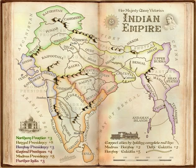
<?xml version="1.0"?>
<map>
<title>Indian Empire</title>
<smallwidth>630</smallwidth>
<smallheight>542</smallheight>
<largewidth>840</largewidth>
<largeheight>723</largeheight>
<filetype>jpg</filetype>
<continent>
<name>Northern Frontier</name>
<bonus>3</bonus>
<components>
<territory>Kafiristan</territory>
<territory>Cashmere</territory>
<territory>Punjab</territory>
<territory>Multan</territory>
<territory>Sirhind</territory>
</components>
</continent>
<continent>
<name>Bengal Presidency</name>
<bonus>8</bonus>
<components>
<territory>Garhwal</territory>
<territory>Delhi</territory>
<territory>Rajpootana</territory>
<territory>Malwa</territory>
<territory>Oude</territory>
<territory>Doab</territory>
<territory>Behar</territory>
<territory>Calcutta</territory>
<territory>Bengal</territory>
<territory>Assam</territory>
<territory>Sikkim</territory>
</components>
</continent>
<continent>
<name>Bombay Presidency</name>
<bonus>3</bonus>
<components>
<territory>Sindh</territory>
<territory>Cutch</territory>
<territory>Kathiawar</territory>
<territory>Ahmedabad</territory>
<territory>Konkan</territory>
</components>
</continent>
<continent>
<name>Central Provinces</name>
<bonus>4</bonus>
<components>
<territory>Central Indian Agency</territory>
<territory>Nagpur</territory>
<territory>Bustar</territory>
<territory>Raipur</territory>
<territory>Orissa</territory>
</components>
</continent>
<continent>
<name>Madras Presidency</name>
<bonus>5</bonus>
<components>
<territory>Kandeish</territory>
<territory>Bejapoor</territory>
<territory>Hyderabad</territory>
<territory>Mysore</territory>
<territory>Carnatic</territory>
<territory>Malabar Coast</territory>
<territory>Ceylon</territory>
<territory>Coromandel Coast</territory>
<territory>Circars</territory>
</components>
</continent>
<continent>
<name>Farther India</name>
<bonus>3</bonus>
<components>
<territory>Upper Burma</territory>
<territory>Shan States</territory>
<territory>Mandalay</territory>
<territory>Arracan</territory>
<territory>Pegu</territory>
<territory>Tenasserim</territory>
<territory>Andaman Islands</territory>
</components>
</continent>
<continent>
<name>Madras - Bombay Railway</name>
<bonus>2</bonus>
<components>
<territory>Coromandel Coast</territory>
<territory>Mysore</territory>
<territory>Bejapoor</territory>
<territory>Konkan</territory>
</components>
</continent>
<continent>
<name>Bombay - Calcutta Railway</name>
<bonus>5</bonus>
<components>
<territory>Konkan</territory>
<territory>Kandeish</territory>
<territory>Nagpur</territory>
<territory>Central Indian Agency</territory>
<territory>Behar</territory>
<territory>Calcutta</territory>
</components>
</continent>
<continent>
<name>Delhi - Calcutta Railway</name>
<bonus>2</bonus>
<components>
<territory>Delhi</territory>
<territory>Doab</territory>
<territory>Behar</territory>
<territory>Calcutta</territory>
</components>
</continent>
<territory>
<name>Kafiristan</name>
<borders>
<border>Cashmere</border>
<border>Punjab</border>
</borders>
<coordinates>
<smallx>172</smallx>
<smally>69</smally>
<largex>230</largex>
<largey>85</largey>
</coordinates>
</territory>
<territory>
<name>Cashmere</name>
<borders>
<border>Kafiristan</border>
<border>Punjab</border>
</borders>
<coordinates>
<smallx>233</smallx>
<smally>98</smally>
<largex>311</largex>
<largey>122</largey>
</coordinates>
</territory>
<territory>
<name>Punjab</name>
<borders>
<border>Kafiristan</border>
<border>Cashmere</border>
<border>Sirhind</border>
<border>Multan</border>
<border>Rajpootana</border>
<border>Garhwal</border>
</borders>
<coordinates>
<smallx>139</smallx>
<smally>138</smally>
<largex>187</largex>
<largey>177</largey>
</coordinates>
</territory>
<territory>
<name>Multan</name>
<borders>
<border>Sindh</border>
<border>Punjab</border>
</borders>
<coordinates>
<smallx>97</smallx>
<smally>171</smally>
<largex>130</largex>
<largey>221</largey>
</coordinates>
</territory>
<territory>
<name>Sirhind</name>
<borders>
<border>Punjab</border>
<border>Garhwal</border>
<border>Delhi</border>
<border>Rajpootana</border>
</borders>
<coordinates>
<smallx>175</smallx>
<smally>142</smally>
<largex>235</largex>
<largey>182</largey>
</coordinates>
</territory>
<territory>
<name>Garhwal</name>
<borders>
<border>Punjab</border>
<border>Delhi</border>
<border>Oude</border>
<border>Sirhind</border>
</borders>
<coordinates>
<smallx>247</smallx>
<smally>139</smally>
<largex>330</largex>
<largey>178</largey>
</coordinates>
</territory>
<territory>
<name>Delhi</name>
<borders>
<border>Garhwal</border>
<border>Sirhind</border>
<border>Rajpootana</border>
<border>Oude</border>
<border>Doab</border>
</borders>
<coordinates>
<smallx>208</smallx>
<smally>161</smally>
<largex>278</largex>
<largey>207</largey>
</coordinates>
</territory>
<territory>
<name>Rajpootana</name>
<borders>
<border>Delhi</border>
<border>Doab</border>
<border>Malwa</border>
<border>Sindh</border>
<border>Punjab</border>
<border>Sirhind</border>
<border>Ahmedabad</border>
</borders>
<coordinates>
<smallx>157</smallx>
<smally>219</smally>
<largex>210</largex>
<largey>284</largey>
</coordinates>
</territory>
<territory>
<name>Malwa</name>
<borders>
<border>Rajpootana</border>
<border>Doab</border>
</borders>
<coordinates>
<smallx>229</smallx>
<smally>251</smally>
<largex>307</largex>
<largey>327</largey>
</coordinates>
</territory>
<territory>
<name>Doab</name>
<borders>
<border>Delhi</border>
<border>Malwa</border>
<border>Rajpootana</border>
<border>Oude</border>
<border>Behar</border>
<border>Central Indian Agency</border>
</borders>
<coordinates>
<smallx>262</smallx>
<smally>217</smally>
<largex>350</largex>
<largey>282</largey>
</coordinates>
</territory>
<territory>
<name>Oude</name>
<borders>
<border>Garhwal</border>
<border>Delhi</border>
<border>Doab</border>
<border>Behar</border>
</borders>
<coordinates>
<smallx>282</smallx>
<smally>172</smally>
<largex>377</largex>
<largey>222</largey>
</coordinates>
</territory>
<territory>
<name>Behar</name>
<borders>
<border>Oude</border>
<border>Doab</border>
<border>Sikkim</border>
<border>Bengal</border>
<border>Assam</border>
<border>Calcutta</border>
<border>Central Indian Agency</border>
</borders>
<coordinates>
<smallx>379</smallx>
<smally>211</smally>
<largex>507</largex>
<largey>274</largey>
</coordinates>
</territory>
<territory>
<name>Sikkim</name>
<borders>
<border>Behar</border>
</borders>
<coordinates>
<smallx>404</smallx>
<smally>180</smally>
<largex>539</largex>
<largey>233</largey>
</coordinates>
</territory>
<territory>
<name>Calcutta</name>
<borders>
<border>Arracan</border>
<border>Behar</border>
<border>Central Indian Agency</border>
<border>Orissa</border>
</borders>
<coordinates>
<smallx>376</smallx>
<smally>273</smally>
<largex>502</largex>
<largey>357</largey>
</coordinates>
</territory>
<territory>
<name>Bengal</name>
<borders>
<border>Assam</border>
<border>Upper Burma</border>
<border>Arracan</border>
<border>Behar</border>
</borders>
<coordinates>
<smallx>448</smallx>
<smally>242</smally>
<largex>599</largex>
<largey>315</largey>
</coordinates>
</territory>
<territory>
<name>Assam</name>
<borders>
<border>Behar</border>
<border>Bengal</border>
<border>Upper Burma</border>
</borders>
<coordinates>
<smallx>469</smallx>
<smally>203</smally>
<largex>626</largex>
<largey>264</largey>
</coordinates>
</territory>
<territory>
<name>Sindh</name>
<borders>
<border>Multan</border>
<border>Rajpootana</border>
<border>Cutch</border>
</borders>
<coordinates>
<smallx>82</smallx>
<smally>233</smally>
<largex>111</largex>
<largey>304</largey>
</coordinates>
</territory>
<territory>
<name>Cutch</name>
<borders>
<border>Sindh</border>
<border>Kathiawar</border>
</borders>
<coordinates>
<smallx>91</smallx>
<smally>254</smally>
<largex>123</largex>
<largey>332</largey>
</coordinates>
</territory>
<territory>
<name>Kathiawar</name>
<borders>
<border>Ahmedabad</border>
<border>Cutch</border>
</borders>
<coordinates>
<smallx>117</smallx>
<smally>289</smally>
<largex>158</largex>
<largey>376</largey>
</coordinates>
</territory>
<territory>
<name>Ahmedabad</name>
<borders>
<border>Kathiawar</border>
<border>Konkan</border>
<border>Rajpootana</border>
</borders>
<coordinates>
<smallx>143</smallx>
<smally>270</smally>
<largex>192</largex>
<largey>352</largey>
</coordinates>
</territory>
<territory>
<name>Konkan</name>
<borders>
<border>Ahmedabad</border>
<border>Malabar Coast</border>
<border>Kandeish</border>
<border>Bejapoor</border>
</borders>
<coordinates>
<smallx>157</smallx>
<smally>323</smally>
<largex>211</largex>
<largey>423</largey>
</coordinates>
</territory>
<territory>
<name>Central Indian Agency</name>
<borders>
<border>Nagpur</border>
<border>Raipur</border>
<border>Orissa</border>
<border>Doab</border>
<border>Behar</border>
<border>Calcutta</border>
</borders>
<coordinates>
<smallx>342</smallx>
<smally>278</smally>
<largex>457</largex>
<largey>363</largey>
</coordinates>
</territory>
<territory>
<name>Nagpur</name>
<borders>
<border>Central Indian Agency</border>
<border>Raipur</border>
<border>Bustar</border>
<border>Kandeish</border>
<border>Hyderabad</border>
</borders>
<coordinates>
<smallx>263</smallx>
<smally>300</smally>
<largex>352</largex>
<largey>393</largey>
</coordinates>
</territory>
<territory>
<name>Raipur</name>
<borders>
<border>Central Indian Agency</border>
<border>Nagpur</border>
<border>Orissa</border>
<border>Bustar</border>
</borders>
<coordinates>
<smallx>307</smallx>
<smally>286</smally>
<largex>412</largex>
<largey>374</largey>
</coordinates>
</territory>
<territory>
<name>Orissa</name>
<borders>
<border>Calcutta</border>
<border>Central Indian Agency</border>
<border>Bustar</border>
<border>Circars</border>
<border>Raipur</border>
</borders>
<coordinates>
<smallx>339</smallx>
<smally>299</smally>
<largex>454</largex>
<largey>391</largey>
</coordinates>
</territory>
<territory>
<name>Bustar</name>
<borders>
<border>Nagpur</border>
<border>Raipur</border>
<border>Circars</border>
<border>Hyderabad</border>
<border>Orissa</border>
</borders>
<coordinates>
<smallx>282</smallx>
<smally>322</smally>
<largex>378</largex>
<largey>422</largey>
</coordinates>
</territory>
<territory>
<name>Kandeish</name>
<borders>
<border>Konkan</border>
<border>Bejapoor</border>
<border>Hyderabad</border>
<border>Nagpur</border>
</borders>
<coordinates>
<smallx>201</smallx>
<smally>293</smally>
<largex>269</largex>
<largey>384</largey>
</coordinates>
</territory>
<territory>
<name>Hyderabad</name>
<borders>
<border>Kandeish</border>
<border>Bejapoor</border>
<border>Coromandel Coast</border>
<border>Bustar</border>
<border>Nagpur</border>
</borders>
<coordinates>
<smallx>229</smallx>
<smally>344</smally>
<largex>307</largex>
<largey>452</largey>
</coordinates>
</territory>
<territory>
<name>Circars</name>
<borders>
<border>Coromandel Coast</border>
<border>Bustar</border>
<border>Orissa</border>
</borders>
<coordinates>
<smallx>324</smallx>
<smally>329</smally>
<largex>433</largex>
<largey>431</largey>
</coordinates>
</territory>
<territory>
<name>Coromandel Coast</name>
<borders>
<border>Circars</border>
<border>Mysore</border>
<border>Carnatic</border>
<border>Ceylon</border>
<border>Hyderabad</border>
</borders>
<coordinates>
<smallx>257</smallx>
<smally>411</smally>
<largex>342</largex>
<largey>543</largey>
</coordinates>
</territory>
<territory>
<name>Ceylon</name>
<borders>
<border>Coromandel Coast</border>
<border>Carnatic</border>
</borders>
<coordinates>
<smallx>276</smallx>
<smally>530</smally>
<largex>369</largex>
<largey>699</largey>
</coordinates>
</territory>
<territory>
<name>Carnatic</name>
<borders>
<border>Ceylon</border>
<border>Coromandel Coast</border>
<border>Malabar Coast</border>
<border>Mysore</border>
</borders>
<coordinates>
<smallx>219</smallx>
<smally>485</smally>
<largex>286</largex>
<largey>644</largey>
</coordinates>
</territory>
<territory>
<name>Malabar Coast</name>
<borders>
<border>Mysore</border>
<border>Carnatic</border>
<border>Konkan</border>
</borders>
<coordinates>
<smallx>180</smallx>
<smally>414</smally>
<largex>241</largex>
<largey>543</largey>
</coordinates>
</territory>
<territory>
<name>Mysore</name>
<borders>
<border>Bejapoor</border>
<border>Coromandel Coast</border>
<border>Carnatic</border>
<border>Malabar Coast</border>
</borders>
<coordinates>
<smallx>227</smallx>
<smally>434</smally>
<largex>300</largex>
<largey>573</largey>
</coordinates>
</territory>
<territory>
<name>Bejapoor</name>
<borders>
<border>Mysore</border>
<border>Konkan</border>
<border>Kandeish</border>
<border>Hyderabad</border>
</borders>
<coordinates>
<smallx>214</smallx>
<smally>372</smally>
<largex>283</largex>
<largey>488</largey>
</coordinates>
</territory>
<territory>
<name>Upper Burma</name>
<borders>
<border>Shan States</border>
<border>Mandalay</border>
<border>Assam</border>
<border>Bengal</border>
</borders>
<coordinates>
<smallx>504</smallx>
<smally>234</smally>
<largex>673</largex>
<largey>304</largey>
</coordinates>
</territory>
<territory>
<name>Shan States</name>
<borders>
<border>Upper Burma</border>
<border>Mandalay</border>
</borders>
<coordinates>
<smallx>547</smallx>
<smally>261</smally>
<largex>731</largex>
<largey>341</largey>
</coordinates>
</territory>
<territory>
<name>Mandalay</name>
<borders>
<border>Upper Burma</border>
<border>Shan States</border>
<border>Tenasserim</border>
<border>Pegu</border>
<border>Arracan</border>
</borders>
<coordinates>
<smallx>500</smallx>
<smally>296</smally>
<largex>668</largex>
<largey>388</largey>
</coordinates>
</territory>
<territory>
<name>Arracan</name>
<borders>
<border>Calcutta</border>
<border>Pegu</border>
<border>Mandalay</border>
<border>Bengal</border>
</borders>
<coordinates>
<smallx>460</smallx>
<smally>285</smally>
<largex>614</largex>
<largey>374</largey>
</coordinates>
</territory>
<territory>
<name>Pegu</name>
<borders>
<border>Andaman Islands</border>
<border>Tenasserim</border>
<border>Arracan</border>
<border>Mandalay</border>
</borders>
<coordinates>
<smallx>503</smallx>
<smally>354</smally>
<largex>672</largex>
<largey>465</largey>
</coordinates>
</territory>
<territory>
<name>Tenasserim</name>
<borders>
<border>Mandalay</border>
<border>Pegu</border>
<border>Andaman Islands</border>
</borders>
<coordinates>
<smallx>541</smallx>
<smally>376</smally>
<largex>723</largex>
<largey>494</largey>
</coordinates>
</territory>
<territory>
<name>Andaman Islands</name>
<borders>
<border>Pegu</border>
<border>Tenasserim</border>
</borders>
<coordinates>
<smallx>445</smallx>
<smally>423</smally>
<largex>595</largex>
<largey>557</largey>
</coordinates>
</territory>
</map>
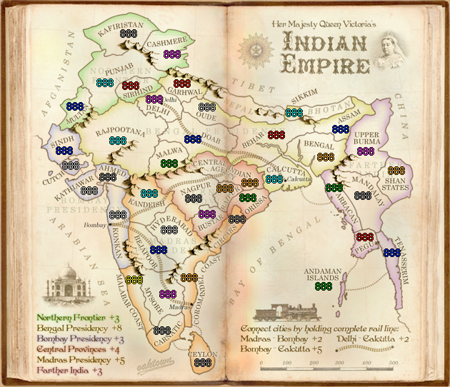
barterer2002 wrote:Oak, I've been thinking about this one for a day now. Most of my concerns have already been discussed but the big one that just bugs me is the ability to fortify 4 terts and get both a continent and a railroad (Madras Presidency and Madras-Bombay). As I think about it, I'm led to a previous discussion about the bonuses of Calcutta-Delhi and I'm less and less convinced that the railroads are a positive on this map-at least from a gameplay perspective. Essentially what we've got is 3 railroad bonuses-2 of which will essentially add to a continent bonus and do little else.
tlane wrote:Hey Oak, this map looks great!
can't really see anything wrong with it, looks very final forge ready.
If you want a nit-pic the only thing I can think of is the border between Pegu and Tenasserim. There is some fat dot or something on the border, you could get rid of that if you want.
Great map,
tlane
barterer2002 wrote:The British fort at Madras was there from (I think) the seventeenth century or so and was well expanded by the time period of this map. I'm interested in your idea of a sea line from Madras over to Calcutta. Doing this would bring you back up to 5 terts that you have to hold to get the bonuses without making this particular railroad a 1 which almost makes it worthless except as part of the continent bonus. If you want to stay with the idea of having the railroads worth something from a starting and game play idea then it needs to stay at +2 IMO.
a.sub wrote:ur utter stunning amazingness ceases to amaze me