Kabanellas wrote:Thanks Incandenza for the critics.
Though I don’t entirely agree (in the essence) with what you said, I think you’ve pointed out some issues that do concern me as well.
Okay, now we're talking. For the record, I really like your Third Crusade map, and hope I can help this map meet that lofty standard. Plus you've already proved that you have the discipline to see the long foundry process through to its conclusion... this process can be a bitch.
The new draft certainly addresses many of my comments, and nobodies already made a head start on bringing to your attention some of the problems that the color-blind will face.
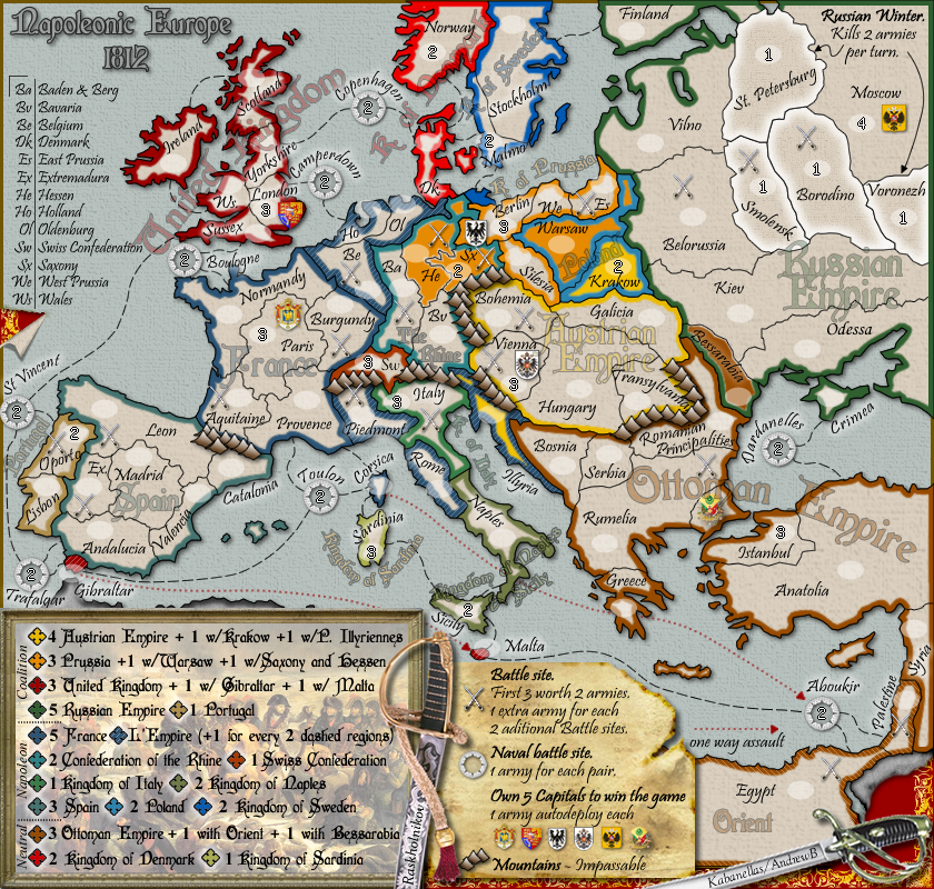
The bonus legend could be cleaned up... I mentioned perhaps sorting the legend alphabetically (within the existing three-way split you have). You could also maybe start thinking about removing some of the "Kingdoms", much the same way that The Rhine lost "Confederacy". Obv the UK is the UK, but the various kingdoms of Sweden, Sardinia, Italy, etc. could just be labeled as "Sweden", etc. The places where this might cause some confusion, i.e. "Kingdom of Denmark" and "Kingdom of Naples" (where the bonus name is also the name of one of the terits within the kingdom) could be alleviated by potentially renaming the Denmark and Naples terits... tho at that point, with the other names cleaned up, you might be able to get away with leaving them as is...
Also within the bonus, sometimes you write out the word "with", sometimes it's a "w/"... you might want to change all of the former to the latter, and maybe make more use of ampersands.
Some of the terit names need to be reconciled: i.e. on the abbreviation legend He is "Hessen & Westphalia", but the bonus legend speaks only of "Hessen". I also maintain that you should consider changing Aboukir to The Nile, but that's small potatoes.
The overall problem, weirdly, is that the large map looks great. All the legibility issues and what not simply don't apply. But you have to have a small map, and a substantial portion of CC (including yours truly, rocking my MacBook) plays exclusively on the small map. And, well, the small map at this point (brace yourself, bad joke coming) is your waterloo. I assume that the small map is at the maximum dimensions according to the CC guidelines (if it's not, you might want to consider growing it a touch, a little bit might go a long way).
The question is how to make the small map more legible: the terit bonus colors could be bolder (especially in the Rhine and Eastern Europe areas), the terit labels could certainly be bolder... but of course those two aims work at cross-purposes, especially where you look at terits like Oldernburg and Holland, where the brighter the terit names, the more difficult it will be to see the dashed bonus indicators. Some of the gameplay elements (the one-way attacks in particular) certainly need to be more prominent. As to the question of how you'll make the bonus colors more amenable to the color-blind... I think more input might be required, but some small palette swaps could be done now (esp. changing either UK or Denmark to something other than reddish, and Poland and the Rhine are pretty close as well). I know the small map thing sucks, but until lack deems otherwise, a legible small map is a requirement.
I'm not sure what the solution for the small map is going to be, graphics aren't my metier. But I like complex maps, and this one shows promise. I'd just like to be able to play it without having to pop some preemptive Tylenol.