Page 4 of 4

Posted:
Mon Oct 16, 2006 5:46 amby gavin_sidhu
mightyal wrote:I'd forgotten about all countries in The Troubled North being able to attack each other. That's a great idea; you should have a symbol (suicide bomber IMO) on each country to emphasize that and state on the legend what the symbol means.
Was thinking about using something like this in the key, but its too small and im pretty sure its copy-writed.

Posted:
Mon Oct 16, 2006 5:59 amby mightyal
Posted:
Mon Oct 16, 2006 8:15 amby reverend_kyle
I find appeal to this map.. attractiveness. no. The first one was best but it seems to get worse each update..
Posted:
Mon Oct 16, 2006 8:39 amby mightyal
I agree that the original version looked best. The rivers are really ugly at the moment. Tamriel has nice rivers (the water texture is good too). I think the shadows really help, as does the narrowing as the rivers near their source.
Posted:
Mon Oct 16, 2006 8:43 amby reverend_kyle
nah his latest update has good rivers.. very north america esque.. although I maintain that for aesthetic things you get photoshop.. alot more options.. drawing borders gimp is a must.
Posted:
Mon Oct 16, 2006 1:23 pmby happysadfun
you could take away some of burma. because not all of it's subcontinental, and since it's a region map and not a country map, you don't have to be totally accurate. it would even work if you just made it a view, like this view:
http://www.meteotest.ch/img/am/gh_indiansubcont.png
Posted:
Tue Oct 17, 2006 2:38 amby gavin_sidhu
I think ill keep burma as is.
To Happysadfun: Could u plz edit ur picture out, it being so large makes it so annoying to read any other posts.
U sure reverend_kyle, i tried using photoshop (albeit only for 5 minutes without reading the instructions) nd found it had pretty much the same things as GIMP.
Posted:
Tue Oct 17, 2006 2:53 amby reverend_kyle
gavin_sidhu wrote:I think ill keep burma as is.
To Happysadfun: Could u plz edit ur picture out, it being so large makes it so annoying to read any other posts.
U sure reverend_kyle, i tried using photoshop (albeit only for 5 minutes without reading the instructions) nd found it had pretty much the same things as GIMP.
have you tried layer effects? maybe its because I know photoshop like the back of my hand but drop shadow bevel and emboss all much improved on photoshop.
Posted:
Tue Oct 17, 2006 3:21 pmby happysadfun
Inkscape has good transparency and good layers. That's all that's good about it. My computer can't install GIMP, eventho it's w2000. So I'm currently using inkscape. it sucks.
Posted:
Thu Oct 19, 2006 12:57 amby AndrewLC
gavin_sidhu wrote: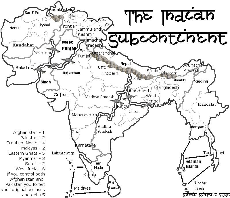
Pick a font. Used happysadfun's mountains, thanks.
It needs colour.
Posted:
Thu Oct 19, 2006 2:38 amby gavin_sidhu
AndrewLC wrote:It needs colour.
I know, wanted to have fonts before i put in the colour.

Posted:
Thu Oct 19, 2006 2:52 amby reverend_kyle
gavin_sidhu wrote:AndrewLC wrote:It needs colour.
I know, wanted to have fonts before i put in the colour.
use photoshop and drop shadow. promise it does wonders.
Himachal Pradesh Should be in india,
Posted:
Thu Oct 19, 2006 10:08 pmby B-Psych101
Himachal Pradesh Should be in india, Jammu and kashmir to, although the dispute is still alive, I probably missed some. I'd play it for sure
Posted:
Tue Nov 07, 2006 1:49 amby DesalationReborn
Just so you know, Aksi Chin is part of and administered by China-- India only makes a marginal claim to it.
Posted:
Tue Nov 07, 2006 2:26 amby gavin_sidhu
DesalationReborn wrote:Just so you know, Aksi Chin is part of and administered by China-- India only makes a marginal claim to it.
Thats why its in the Troubled North, not India.
Work on this map might b slow, trying to figure out how to use photoshop and busy in rl.
Names
Posted:
Wed Jan 17, 2007 10:34 amby pittman
Hey Gavin, that looks good to me.
Instead of using South India, you could simply call it Dakshin. West could be Paschim, and East could be Purab. North is Uttar.
I think Karnataka and Andhra Pradesh really come under South. Chattisgarh, Madhya Pradesh, Maharashtra, Gujarat, are usually considered west. You could club Kashmir with the remaining northern states or add Uttaranchal to the North (which it actually is). You have the option to club Pakistan and Afghanistan. The Eastern states could be clubbed with Burma and Bangladesh if you need to reduce continents.
Don't forget to put in the Himalayan range between the eastern states and Nepal. After all that's the highest mountain range in the world! The Siachen mountain ranges come between Kashmir and Pakistan, which actually is the highest battlefield in the world!
This would make the whole thing a very convincing and credible experience!
All the best.
Names
Posted:
Fri Jan 19, 2007 5:46 amby pittman
One more thing, for all those wondering what "pradesh" means. It means "state." For example Uttar Pradesh means Northern State, although it is a proper noun. Similarly Madhya is "central."
For those who are wondering why this does not look like India. Well this is the Indian subcontinent, not the country of India. This is what India looked like a few centuries ago before it got all split up.
I realise later that you had added in the mountain ranges in the latter maps. Cool.
Ciao

Posted:
Sat Jan 27, 2007 12:07 amby gavin_sidhu
U seem very knowledgable on the region pittman, do u wish to take over the map? i could send u the files. I sort of abandoned this map after the indian presidencies was thought up of, that map looks soo much better than mine, but it seems the cartographer gave up on the map.
Posted:
Sun Jan 28, 2007 2:54 pmby happysadfun
gavin_sidhu wrote:U seem very knowledgable on the region pittman, do u wish to take over the map?
he lives there.
Not my area
Posted:
Thu Feb 01, 2007 3:45 amby pittman
Yup, that's right, I live here. It's my country.
But I don't really think I can take over from you. This isn't really my area of expertise. We can collaborate though if that will helpful.

Indian Prsidencies
Posted:
Thu Feb 01, 2007 3:57 amby pittman
I checked out the Indian presidencies map. It looks nice but is set in a different time frame and the spellings are atrocious.
I think yours is much more authentic and that goes for mountain ranges etc.
