Page 2 of 35

Posted:
Fri Jan 25, 2008 9:46 amby Lone.prophet
Unit_2 wrote:on yours or on mine?
what you mean?
Posted:
Fri Jan 25, 2008 10:08 amby Unit_2
put the territorys/names on my map or your map?
Posted:
Fri Jan 25, 2008 10:09 amby Lone.prophet
you can put the names on your map and ill implant them on mine
Posted:
Sun Jan 27, 2008 6:04 amby Lone.prophet
Newest update

Posted:
Sun Jan 27, 2008 8:46 amby Lone.prophet

something with amry cicles and some connections will be next anyone have suggestions for them?
Posted:
Sun Jan 27, 2008 12:37 pmby valeria
Should be: Cape Breton, not cape brenton.
Should be St. John's, not Saint John ( in Newfoundland)
Suggestion for Evangeline: Annapolis Valley or Evangeline Trail
Suggestion for Sunrise Trail: Halifax, Antigonish, Guysborough
It's looking really good though. I'm not great at figuring out borders. I am really good at making suggestions once someone else has filled in the blanks. Any other geography questions, I'd be more than willing to help out.
You can almost see my house... at the eastern tip of Cape Breton!
Posted:
Sun Jan 27, 2008 12:55 pmby DiM
just curious, what exactly does unit_2 for this map?
i mean at least for japan he came up with the idea (not first since there were many others before him that suggested it), but here it's not even his idea since gozar suggested it.
Posted:
Sun Jan 27, 2008 12:59 pmby Lone.prophet
valeria wrote:Should be: Cape Breton, not cape brenton.
Should be St. John's, not Saint John ( in Newfoundland)
Suggestion for Evangeline: Annapolis Valley or Evangeline Trail
Suggestion for Sunrise Trail: Halifax, Antigonish, Guysborough
It's looking really good though. I'm not great at figuring out borders. I am really good at making suggestions once someone else has filled in the blanks. Any other geography questions, I'd be more than willing to help out.
You can almost see my house... at the eastern tip of Cape Breton!
thnx man if you see anything else wrong plz be so kind to post it:)
and dim he did all the resource so far we will see what else he will bring in
Posted:
Sun Jan 27, 2008 1:05 pmby DiM
Lone.prophet wrote:
and dim he did all the resource so far we will see what else he will bring in
what resource??

Posted:
Sun Jan 27, 2008 1:07 pmby Lone.prophet
well how it should be devided and what to call everything
Posted:
Sun Jan 27, 2008 1:14 pmby DiM
Lone.prophet wrote:well how it should be devided and what to call everything
hint. look on page 1. gozar gave him the idea and the image.

he even told him how to search for images:
Gozar wrote:Unit_2 wrote:Gozar, what did you seach to get that with territorys?
Maritime counties in google images
not much research needed if you ask me.
and btw.
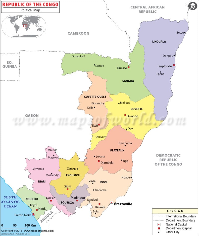
lone.prophet here's a map of congo with names and everything:
http://www.mapsofworld.com/republic-of-congo/maps/republic-of-congo-political-map.jpg
i did an exhausting 10 second research. will you make a map for me? don't forget to put my name on it. and when you do it, i'll start pming every cartographer to do my xml so i can get this quenched. ok?
Posted:
Sun Jan 27, 2008 1:17 pmby Lone.prophet
wow you are really frustrated i see
Posted:
Sun Jan 27, 2008 1:19 pmby DiM
Lone.prophet wrote:wow you are really frustrated i see
nope i'm just trying to get my name on as many maps as possible while doing no work at all.
so will you do congo for me?
i need an answer cause if you don't want to i still have a lot more ideas and i can also pm all the cartographers. so this is your final chance ...

Posted:
Sun Jan 27, 2008 1:20 pmby Lone.prophet
Well your congo map doesnt have ass much territories can you devide it up some more so i know exactly what to do and ill make a shiny map out of it
Posted:
Sun Jan 27, 2008 1:22 pmby DiM
Lone.prophet wrote:Well your congo map doesnt have ass much territories can you devide it up some more so i know exactly what to do and ill make a shiny map out of it
the cities are the terits. just connect them with lines like the midkemdil map
and the colours represent the continents
oh and the province capitals give +1 as well as the national capital
Posted:
Sun Jan 27, 2008 1:24 pmby Lone.prophet
na i dont like a map like that maybe you should ask another artist to make your map than. i am more an old school map person!

Posted:
Sun Jan 27, 2008 1:31 pmby DiM
Lone.prophet wrote:na i dont like a map like that maybe you should ask another artist to make your map than. i am more an old school map person!
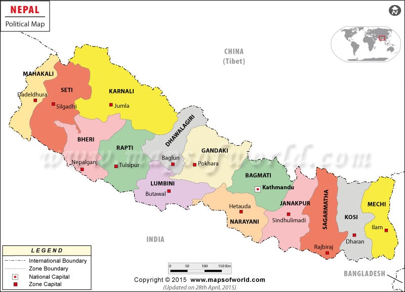
ok i'll ask somebody else to do congo. and since you like something oldschool here's another idea. i told you i have lots of ideas. i mean googling maps is really easy.
here's nepal.
all the continents:
http://www.mapsofworld.com/nepal/maps/nepal-political-map.jpg
and all the terits:
http://www.mapsofworld.com/nepal/maps/nepal_distric_map.gif
Posted:
Sun Jan 27, 2008 1:36 pmby Lone.prophet
thats cool i would really like to do a nepal map (lots of cool mountain terrain)
but could you make it a bit less territories?
Posted:
Sun Jan 27, 2008 1:38 pmby DiM
Lone.prophet wrote:thats cool i would really like to do a nepal map (lots of cool mountain terrain)
but could you make it a bit less territories?
no problem you start the general map and i'll pm you the terits.
i just need to google some more.
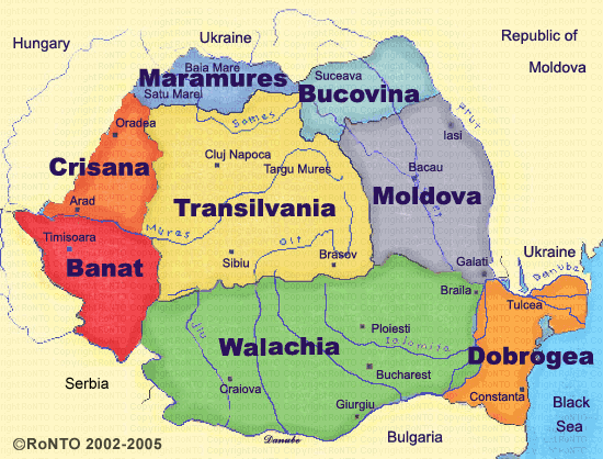
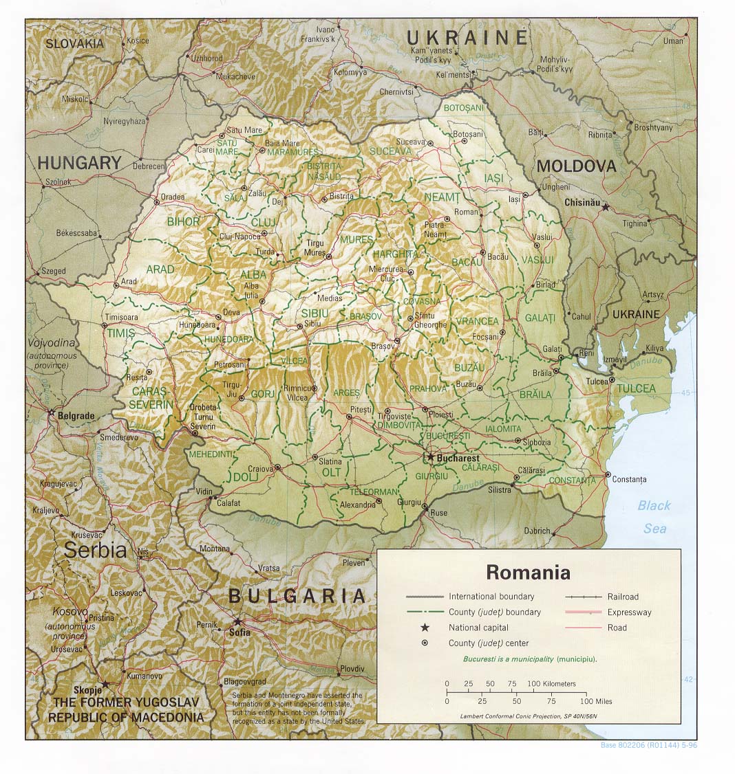
and even better if you like mountains do my country Romania. some of the nicest mountains are here.
district map
http://www.aboutromania.com/RomaniaCountiesMap.gif
continents map
http://www.romaniatourism.com/map/regional_map.gif
geographic map
http://www.lib.utexas.edu/maps/europe/romania_rel96.jpg
Posted:
Sun Jan 27, 2008 2:23 pmby Gozar
How many territories on this one? Does not seem like many.
Also it should be "River Valley" in NB, not "River Falley"
Personally, I would still rather it have a more "maritimes" feel. Right now, Quebec seems to be the focus.
Posted:
Sun Jan 27, 2008 2:25 pmby Lone.prophet
thnx for the typo pointout will change
here is another version dunno what i changed all

and dim go do thing in another thread
Posted:
Sun Jan 27, 2008 2:39 pmby Unit_2
Good job L.P
thats looking awsome!
As for you DiM(wit) I made the map...i did not copy it fro many where, i lookes at some maps and made the basic map and L.P. is doing the graphics.
Posted:
Sun Jan 27, 2008 2:52 pmby DiM
Unit_2 wrote:As for you DiM(wit) I made the map...i did not copy it fro many where, i lookes at some maps and made the basic map and L.P. is doing the graphics.
dimwit is another user. he made the doodle map. he's my multi. don't confuse me with me.
as for you making the map...hmmm...i look at the image above and all i see is lp's work. not yours.
and to be ontopic.
i love the current state of the map. textures are great.
the minimap could use some fancier gfx and the border between water and the green dead terit is a bit pixelly with shades of white.
Posted:
Sun Jan 27, 2008 2:55 pmby Lone.prophet
and to be ontopic.
i love the current state of the map. textures are great.
the minimap could use some fancier gfx and the border between water and the green dead terit is a bit pixelly with shades of white.
ok yeah i just put the minimap in as a impression for now i will be working on that
and the space between sea and dead territory is weird but i will come up with a solution

Posted:
Sun Jan 27, 2008 3:03 pmby DiM
Lone.prophet wrote:and to be ontopic.
i love the current state of the map. textures are great.
the minimap could use some fancier gfx and the border between water and the green dead terit is a bit pixelly with shades of white.
ok yeah i just put the minimap in as a impression for now i will be working on that
and the space between sea and dead territory is weird but i will come up with a solution
also could you perhaps mute the green dead space. it may be my monitor but as it is now it sort of has a plastic like glow.