Mexico Map
Moderator: Cartographers
61 posts
• Page 3 of 3 • 1, 2, 3
![]() by fluffybunnykins on Tue Jul 25, 2006 1:58 am
by fluffybunnykins on Tue Jul 25, 2006 1:58 am
I think the names you've done are much better than E.../ W... etc. cool
Superman wears 'Fluffybunnykins' pyjamas
-

 fluffybunnykins
- Posts: 385
- Joined: Tue May 02, 2006 6:43 am
- Location: Liverpool, UK

![]() by gavin_sidhu on Tue Jul 25, 2006 2:26 am
by gavin_sidhu on Tue Jul 25, 2006 2:26 am
maritovw wrote:COMMENTS PLEASE!!!
Lol i know what u mean about comments, ppl in the map foundry arent that talkative.
Have u thought how ur going to get all those maps together, is it possible to do easily. Also all your continents seem large, you dont seem to have any small continents like australia, but maybe your not looking to create a map like Classic. Its coming on good otherwise.
Highest Score: 1843 Ranking (Australians): 3
-

gavin_sidhu
- Posts: 1428
- Joined: Mon May 22, 2006 6:16 am
- Location: Brisbane, Australia
![]() by AndyDufresne on Tue Jul 25, 2006 2:37 am
by AndyDufresne on Tue Jul 25, 2006 2:37 am
Lol i know what u mean about comments, ppl in the map foundry arent that talkative
I'm afraid you are quite mistaken on that point. They are just selectively talkative.
--Andy
-

AndyDufresne
- Posts: 24919
- Joined: Fri Mar 03, 2006 8:22 pm
- Location: A Banana Palm in Zihuatanejo


![]() by maritovw on Tue Jul 25, 2006 10:59 am
by maritovw on Tue Jul 25, 2006 10:59 am
i've drawn those maps so it will be easy to draw the big one... i know they are kinda big but that is only for now... the "one" will be the right size... and about getting the whole map, i just have to plan how to divide the caribbean and south america so that i get the right amount of territories...
i'm thinking to divide the caribbean in Great Antilles / Small Antilles so that there is a small continents too...
i'm thinking to divide the caribbean in Great Antilles / Small Antilles so that there is a small continents too...
-

maritovw
- Posts: 195
- Joined: Mon Jul 17, 2006 10:05 pm
- Location: Guatemala
![]() by maritovw on Tue Jul 25, 2006 6:13 pm
by maritovw on Tue Jul 25, 2006 6:13 pm
here it is!!! this is my map layout:
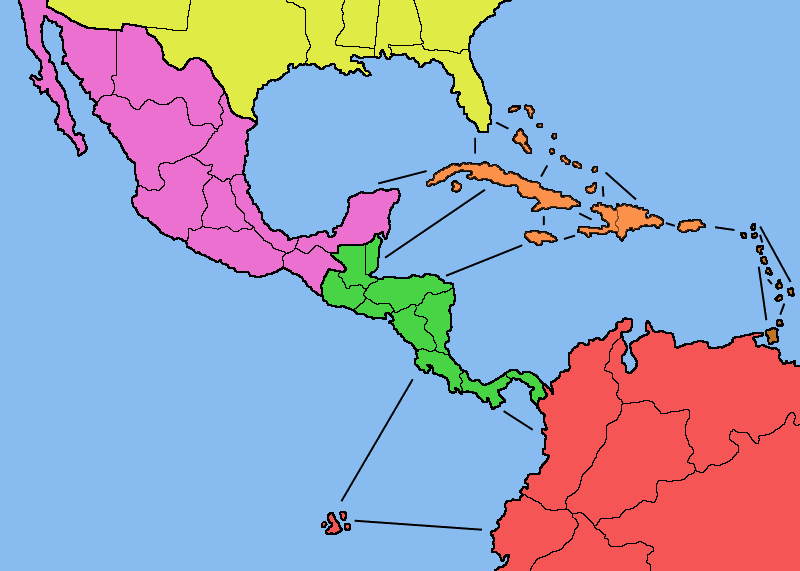
it has the right size for the large map. it has 44 territories:
USA: Arizona, Texas, Louisiana, Mississippi, Alabama, Georgia, Florida
MEXICO: Baja California, Chihuahua, Nuevo Leon, Durango, Jalisco, Mexico D.F., Veracruz, Oaxaca, Chiapas, Yucatan
CENTRO AMERICA: Guatemala, Peten, Belice, Honduras, El Salvador, Managua, Zelaya, Costa Rica, Colon, Panama
GREATER ANTILLES: Cuba, Bahamas, Jamaica, Haiti, Republica Dominicana, Puerto Rico
LESSER ANTILLES: Virgin Islands, Leeward Islands, Windward Islands, Trinidad and Tobago
SUR AMERICA: Antioquia, Meta, Venezuela, Ecuador, Loreto, Amazonas, Islas Galapagos
i'll remove the previous images so the forum doesnt look so bulky...
should i open a new thread now that i have a map and i will be improving it on a regular basis??? ... maybe it will attract more the attention of people and their comments if they see the map and all its info in the first post....
Last edited by maritovw on Wed Jul 26, 2006 12:44 am, edited 1 time in total.
-
maritovw
- Posts: 195
- Joined: Mon Jul 17, 2006 10:05 pm
- Location: Guatemala
![]() by Marvaddin on Tue Jul 25, 2006 10:30 pm
by Marvaddin on Tue Jul 25, 2006 10:30 pm
Im not discussing names, but the map seems ok, except for:
1) some countries seem to be not big enough to place both name and number; for example, I can imagine this in the lesser antilles
2) there are many routes between the isles, this is not necessary.
3) the green continent is not holdable, it has 7 ( ) borders.
1) some countries seem to be not big enough to place both name and number; for example, I can imagine this in the lesser antilles
2) there are many routes between the isles, this is not necessary.
3) the green continent is not holdable, it has 7 (

-

Marvaddin
- Posts: 2545
- Joined: Thu Feb 09, 2006 5:06 pm
- Location: Belo Horizonte, Brazil


![]() by maritovw on Wed Jul 26, 2006 12:33 am
by maritovw on Wed Jul 26, 2006 12:33 am
Marvaddin wrote:1) some countries seem to be not big enough to place both name and number; for example, I can imagine this in the lesser antilles
I was thinking of putting the number on the country (or at least in the center of the isle group) and the name on the sea, by its side (the names could go like in your philippines map)
Marvaddin wrote:2) there are many routes between the isles, this is not necessary.
you mean about the line showing the connection between them?? yes, i was planning to remove most of them...
Marvaddin wrote:3) the green continent is not holdable, it has 7 (
hmmm, i think you are right, i will remove a couple...
hey, and would you get mad if i stole some of your dark colors in your philippines map?
and what about opening a new thread for this map??
-
maritovw
- Posts: 195
- Joined: Mon Jul 17, 2006 10:05 pm
- Location: Guatemala
![]() by gavin_sidhu on Wed Jul 26, 2006 1:23 am
by gavin_sidhu on Wed Jul 26, 2006 1:23 am
The thing i dont like about this map is that it is that it is a diagonal line with nothing in the top right corner and bottom left corner but lots of stuff in the other corners. The blue space scares me, then again im guessing youll fill it up with the title and key.
I think that instead of stretching lousiana to alabama, you should stretch florida to mississippi. It looks kinda not natural nor right now.
What i like about this map is that it will be one of the few geographic maps on CC that dont have any unpassable objects.
I agree with marvaddin about the connections in the carrabien, theyre confusing.
And i think you should create a new thread because this one says mexico and your map aint mexico (what is it? central america maybe?)
Highest Score: 1843 Ranking (Australians): 3
-
gavin_sidhu
- Posts: 1428
- Joined: Mon May 22, 2006 6:16 am
- Location: Brisbane, Australia
![]() by maritovw on Wed Jul 26, 2006 1:03 pm
by maritovw on Wed Jul 26, 2006 1:03 pm
thanks gavin, i'll try your suggestion about stretching florida to mississippi. this map was like only to show the general layout so don't be scared about that blue  there was exactly were i planned to put the title and key.. i'll also add some texture to the map and change the colors, maybe i'll darken them...
i'm opening a new thread as soon as i have a new version of the map...
i'm opening a new thread as soon as i have a new version of the map...
-
maritovw
- Posts: 195
- Joined: Mon Jul 17, 2006 10:05 pm
- Location: Guatemala
![]() by Marvaddin on Wed Jul 26, 2006 1:18 pm
by Marvaddin on Wed Jul 26, 2006 1:18 pm
Of course, you can use some of the colours in my map, they are not mine, colours belong to no one 
Ok, removing connections and merge some countries (like Belize and Peten) will be good, but you dont know how to place the names and numbers will be difficult, guy. Think about all those names just under Haiti and Cuba. No way, its terrible, you will probably need to add some more space to the right side of the map, making room for more south america. I suggest you try it, and post a map with names. We can then comment.
Ok, removing connections and merge some countries (like Belize and Peten) will be good, but you dont know how to place the names and numbers will be difficult, guy. Think about all those names just under Haiti and Cuba. No way, its terrible, you will probably need to add some more space to the right side of the map, making room for more south america. I suggest you try it, and post a map with names. We can then comment.
-
Marvaddin
- Posts: 2545
- Joined: Thu Feb 09, 2006 5:06 pm
- Location: Belo Horizonte, Brazil
61 posts
• Page 3 of 3 • 1, 2, 3
Return to Melting Pot: Map Ideas
Who is online
Users browsing this forum: No registered users
|
|||||||
| Conquer Club is not associated with RISK online in any way. Copyright © 2006-2024 by Big Wham LLC | |||||||