Conquer Club

Indian Empire [Quenched]

Care to peruse completed maps? Take a stroll through the Atlas.

Moderator: Cartographers

Forum rules
Please read the Community Guidelines before posting.

Re: Indian Empire (D) page 8

Postby a.sub on Sun Feb 08, 2009 2:52 pm

The Neon Peon wrote:
a.sub wrote:
The Neon Peon wrote:The map looks great.

I have no complaints. Might move yourself to Final Forge.


can mods move themselves?

I am pretty sure that oak is the one who stamps everyone into the Final Forge.


cool, i didnt know that
User avatar
Cadet a.sub
 
Posts: 1834
Joined: Thu Jun 14, 2007 2:07 am

Re: Indian Empire (D) page 8

Postby oaktown on Sun Feb 08, 2009 6:04 pm

The Neon Peon wrote:The map looks great.

I have no complaints. Might move yourself to Final Forge.

I have to be stamped just like everybody else... we don't want to set up a two-tier system. Gimil is the master of the graphics stamp, iancanton the gameplay stamp. Once we get over those hurdles I'll figure out who will be the voice of forging.
User avatar
Captain oaktown
 
Posts: 4451
Joined: Sun Dec 03, 2006 9:24 pm
Location: majorcommand

Re: Indian Empire (D) page 8

Postby oaktown on Mon Feb 09, 2009 10:24 pm

yeti_c wrote:Shouldn't "Farther India" actually be "Further India"?

"Farther India is an old term, now rarely used, for Southeast Asia, seen in colonial days from Europe as the part of the Far East beyond the Indian subcontinent, but south of China." (wikipedia)

"Farther" refers to physical distance, while "further" is used to identify a thing as being to a greater degree of something measurable other than distance, usually time. Gandhi's influence spread farther than the British had expected, which jeopardized their further reign over the country.

I would appreciate further comments on this map.
User avatar
Captain oaktown
 
Posts: 4451
Joined: Sun Dec 03, 2006 9:24 pm
Location: majorcommand

Re: Indian Empire (D) page 7

Postby iancanton on Fri Feb 13, 2009 6:03 pm

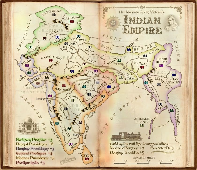
ZeakCytho wrote:What if you made an attack route from Calcutta to Arracan? Arracan is already a border, so it doesn't make the continent any harder to capture/defend initially, but it makes the player hold two borders to defend the continent after expansion to Behar. This is more justified for the +3, I think.

oaktown wrote:Added a sea attack route from Calcutta to Aracan. This is a better route than those previously suggested since it does not create any new border territories, but it solves the problem of Farther India being progressively easier to hold as that player expands.

this is undoubtedly an improvement from previously. despite the above, farther india does remain the obvious place to hide in a multi-player game.

to counter this, i'd like to see the bombay-calcutta railway bonus, which can be attacked from all bonus regions except one, bumped up to not less than +6 to encourage play in the central part of the map.

the madras presidency is overvalued at +6 because the natural expansion to bombay brings an extra +2 for the railway, with a reasonable defensive position. reducing madras to +5 will fix that. similarly, for bengal presidency, i recommend a reduction to +7 because it includes all of the delhi-calcutta railway, worth an additional +2, within its borders.

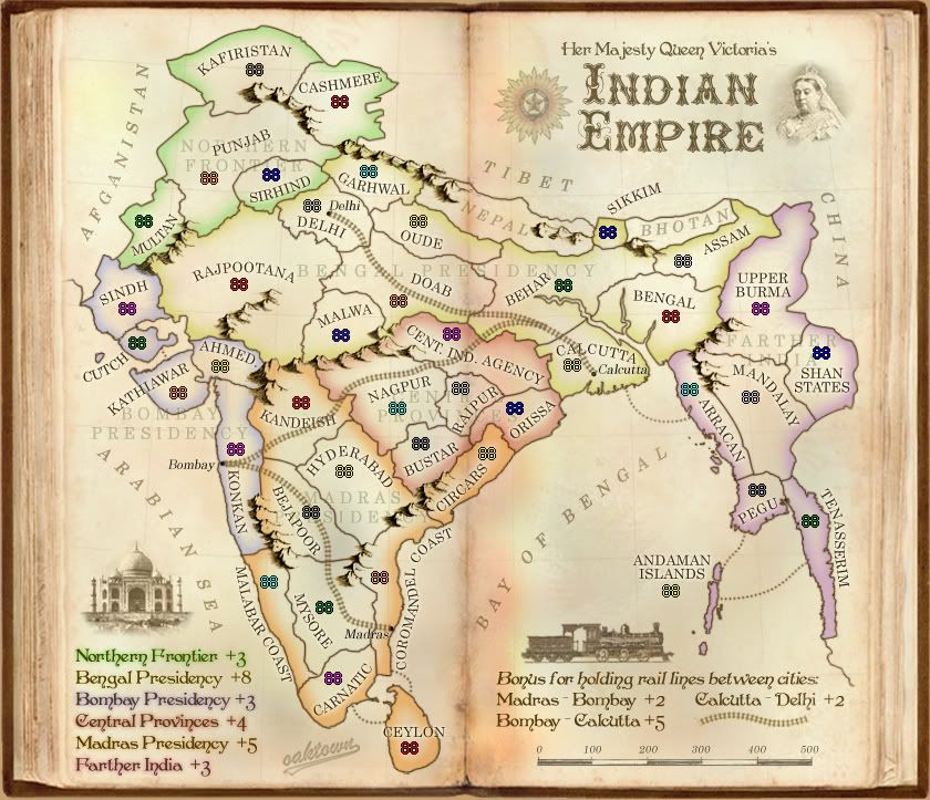
oaktown wrote:added "China" to the east.

at the time, as is now also the case, tibet was part of china, so how about replacing both names by chinese empire?

rather than northern territories, i suggest that the legendary northwest frontier is a fitting name for the green region.

http://en.wikipedia.org/wiki/North-West ... ry_history)

i didn't realise that kafiristan was a real place. the first time i came across the name was in the man who would be king and i assumed it was totally made-up!

http://www.imdb.com/title/tt0073341/

ian. :)
User avatar
Colonel iancanton
Foundry Foreman
Foundry Foreman
 
Posts: 2424
Joined: Fri Jun 01, 2007 5:40 am
Location: europe

Re: Indian Empire (D) page 8

Postby LED ZEPPELINER on Sat Feb 14, 2009 9:42 pm

are you sure dotted lines are the way to go, maybe dashes, or solid lines, i just don't think that if this was drawn in a book, somebody would take the time to make each dot, and make them all perfect. Just a thought
Sergeant LED ZEPPELINER
 
Posts: 1088
Joined: Tue Nov 25, 2008 10:09 pm

Re: Indian Empire (D) page 8

Postby the.killing.44 on Sun Feb 15, 2009 12:37 am

LED ZEPPELINER wrote:are you sure dotted lines are the way to go, maybe dashes, or solid lines, i just don't think that if this was drawn in a book, somebody would take the time to make each dot, and make them all perfect. Just a thought

Well this is a printed book, not hand-drawn, so they most likely would be perfect. I think they're fine as is.

.44
User avatar
Captain the.killing.44
 
Posts: 4724
Joined: Thu Oct 23, 2008 7:43 pm
Location: now tell me what got two gums and knows how to spit rhymes

Re: Indian Empire (D) page 8

Postby thenobodies80 on Fri Feb 20, 2009 11:31 am

wow , i want play this map!

bothan? are you sure?

http://en.wikipedia.org/wiki/Bhutan

I don't like territory names there's nothing more thematic?

i suggest you, if can :oops: , to remove continents name on map,traspharency is high, but the titles confused me anyways
Mountains are wonderfull, i love them!
the map border (dark brown one) could be nicer ;)
Last edited by thenobodies80 on Thu Mar 05, 2009 5:36 pm, edited 2 times in total.
User avatar
Sergeant 1st Class thenobodies80
 
Posts: 5400
Joined: Wed Sep 05, 2007 4:30 am
Location: Milan

Re: Indian Empire (D) page 8

Postby yeti_c on Mon Mar 02, 2009 7:53 am

oaktown wrote:
yeti_c wrote:Shouldn't "Farther India" actually be "Further India"?

"Farther India is an old term, now rarely used, for Southeast Asia, seen in colonial days from Europe as the part of the Far East beyond the Indian subcontinent, but south of China." (wikipedia)

"Farther" refers to physical distance, while "further" is used to identify a thing as being to a greater degree of something measurable other than distance, usually time. Gandhi's influence spread farther than the British had expected, which jeopardized their further reign over the country.

I would appreciate further comments on this map.


Seems fair to me.

C.
Image
Highest score : 2297
User avatar
Lieutenant yeti_c
 
Posts: 9624
Joined: Thu Jan 04, 2007 9:02 am

Re: Indian Empire (D) page 8

Postby oaktown on Fri Mar 13, 2009 1:18 am

Click image to enlarge.
image


Alright, I haven't been at this map in a long while. In addition to some minor graphic modifications I've incorporated a number of recent suggestions as follows...

Dotted attack lines changed to dashes. I'm not sure it will work since some attack routes are short and the dashes get lost. Plus Photoshop just doesn't do dashed lines very well and it may not be worth the effort to smooth them out fully, but I'll play with the idea for another draft or two.

Northern Territories changed to Northern Frontier... Northwest Frontier was suggested, but for whatever reason this sounded better to me. I might change my mind in 24 hours. Actually I only changed the name on the legend - oops.

Madras bonus dropped to +5. I see that it has many expansion options, and will probably be taken by whoever nabs the southern rail bonus, giving an additional +2.

Bombay Calcutta route bonus upped to +5... +6 was suggested, but I had trouble pulling the trigger and going that high. It'll be bitch to hold on its own chances are it will be coupled with another bonus such as Central Provinces, and when I think of that bonus being coupled +6 seems really generous.

iancanton wrote:i didn't realise that kafiristan was a real place. the first time i came across the name was in the man who would be king

Actually, I came across the name on an old map when I was researching this, and since I love the movie so much I just had to use it. Peachy Carnahan is in da house! Michael Caine is fantastic in everything he is in, which is about 40% of all films made in English in the past 50 years (and one really odd Madness track).
User avatar
Captain oaktown
 
Posts: 4451
Joined: Sun Dec 03, 2006 9:24 pm
Location: majorcommand

Re: Indian Empire (D) page 9

Postby captainwalrus on Fri Mar 13, 2009 2:23 pm

Why is sikkin (the word) on such a steep angle? It isn't like it can fit even partially in the territory no matter how you bend it so why not make it more level. And perhaps you could make it more book-like by making the names and borders along the crease bent a little. It would take some time but it might really enhance the effect, It is worth toying with.
User avatar
Private 1st Class captainwalrus
 
Posts: 1018
Joined: Sun Nov 11, 2007 3:19 pm
Location: Finnmark

Re: Indian Empire (D) page 9

Postby oaktown on Sat Mar 14, 2009 4:25 pm

captainwalrus wrote:And perhaps you could make it more book-like by making the names and borders along the crease bent a little. It would take some time but it might really enhance the effect, It is worth toying with.

I did this on the original Brazil revamp entry that I'd used this background for... I intend to do it here, but it's a considerable bit of work to get this effect right for all map elements, and I don't want to have to do it twice.
User avatar
Captain oaktown
 
Posts: 4451
Joined: Sun Dec 03, 2006 9:24 pm
Location: majorcommand

Re: Indian Empire (D) page 9

Postby a.sub on Sat Mar 14, 2009 4:50 pm

oaktown wrote:
captainwalrus wrote:And perhaps you could make it more book-like by making the names and borders along the crease bent a little. It would take some time but it might really enhance the effect, It is worth toying with.

I did this on the original Brazil revamp entry that I'd used this background for... I intend to do it here, but it's a considerable bit of work to get this effect right for all map elements, and I don't want to have to do it twice.

good call
so what do you need to get it to the next level?
just a "I like the game play" from the general public?
User avatar
Cadet a.sub
 
Posts: 1834
Joined: Thu Jun 14, 2007 2:07 am

Re: Indian Empire (D) page 9

Postby the.killing.44 on Sat Mar 14, 2009 6:29 pm

Just a small thing, but on Calcutta the - - - - - path runs into the territory a bit. And speaking of those, they seem very rough and pixely …
Anyway I don't see anything really wrong here … nice job oak.

.44
User avatar
Captain the.killing.44
 
Posts: 4724
Joined: Thu Oct 23, 2008 7:43 pm
Location: now tell me what got two gums and knows how to spit rhymes

Re: Indian Empire (D) page 8

Postby iancanton on Mon Mar 16, 2009 4:57 pm

oaktown wrote:Bombay Calcutta route bonus upped to +5... +6 was suggested, but I had trouble pulling the trigger and going that high. It'll be bitch to hold on its own chances are it will be coupled with another bonus such as Central Provinces, and when I think of that bonus being coupled +6 seems really generous.

this is a very open map, so bonuses do tend to be on the high side compared with other maps. some mountains, perhaps next to delhi or garhwal, might act as some protection for the bengal presidency, if u consider that they won't shield the northern territories too much. the gameplay is, however, perfectly good without them.

Image

ian. :)
Image
User avatar
Colonel iancanton
Foundry Foreman
Foundry Foreman
 
Posts: 2424
Joined: Fri Jun 01, 2007 5:40 am
Location: europe

Re: Indian Empire (D) page 9

Postby Joodoo on Tue Mar 17, 2009 2:29 am

I'm still confused about the rail lines, does holding the rail line means holding all territories that the line passes? if yes, can territories within the same rail line attack each other (ex.can Delhi attack Behar)?
TheSaxlad wrote:The Dice suck a lot of the time.

And if they dont suck then they blow.

:D
User avatar
Lieutenant Joodoo
 
Posts: 1639
Joined: Fri Mar 21, 2008 12:19 am
Location: Greater Toronto, Canada

Re: Indian Empire (D) page 9

Postby oaktown on Wed Mar 18, 2009 10:49 pm

Click image to enlarge.
image


Thanks for the stamp, ian... your suggestion about adding mountains between Northern and Bengal is good - Himalayas should be better represented on the map anyhow - but i think the move may have just downgraded northern to a +2. ??

Went back to dotted sea-attack routes. I'll play with them more.

Revised the rail bonus explanation a bit. I hope it is now more clear.
User avatar
Captain oaktown
 
Posts: 4451
Joined: Sun Dec 03, 2006 9:24 pm
Location: majorcommand

Re: Indian Empire (D) page 9

Postby iancanton on Fri Mar 20, 2009 6:16 pm

oaktown wrote:Thanks for the stamp, ian... your suggestion about adding mountains between Northern and Bengal is good - Himalayas should be better represented on the map anyhow - but i think the move may have just downgraded northern to a +2. ??

actually, i think northern frontier is a +2 just now, more than a +3. when stamping, i thought it had 3 borders, but 2 of them are punjab! consider removing the mountains between multan and sindh to create an extra border, so that we don't have two bonuses whose only neighbour is bengal presidency. this ought to keep the northern frontier at +3 while not compromising bombay presidency excessively - perhaps push the latter up to +4 if u do this because it's difficult to fort within bombay presidency unless u either hold the whole bonus region or have rajpootana.

ian. :)
Image
User avatar
Colonel iancanton
Foundry Foreman
Foundry Foreman
 
Posts: 2424
Joined: Fri Jun 01, 2007 5:40 am
Location: europe

Re: Indian Empire (D, GP) page 10

Postby a.sub on Fri Mar 20, 2009 6:32 pm

i think the rail bonus is even more confusing now lol
Hold all the states a rail passes on to get the bonus
Rail:.........Bonus
A to B.........7
C to D.........-12
E to F.........3285790
Z to π.........3.14159

you get the point :lol:
User avatar
Cadet a.sub
 
Posts: 1834
Joined: Thu Jun 14, 2007 2:07 am

Re: Indian Empire (D, GP) page 10

Postby LED ZEPPELINER on Fri Mar 20, 2009 7:42 pm

just wondering, is that scale correct, if it isn't i think it would be cool if it was, but no big deal
Sergeant LED ZEPPELINER
 
Posts: 1088
Joined: Tue Nov 25, 2008 10:09 pm

Re: Indian Empire (D, GP) page 10

Postby mibi on Fri Mar 20, 2009 7:54 pm

This map is hot. Though I can not a huge fan of the ornamental title treatment. Looks incongruous.
User avatar
Captain mibi
 
Posts: 3350
Joined: Thu Mar 01, 2007 8:19 pm
Location: The Great State of Vermont

Re: Indian Empire (D, GP) page 10

Postby yeti_c on Thu Mar 26, 2009 3:55 pm

"scale of miles" sounds a bit funny?!

C.
Image
Highest score : 2297
User avatar
Lieutenant yeti_c
 
Posts: 9624
Joined: Thu Jan 04, 2007 9:02 am

Re: Indian Empire (D, GP) page 10

Postby Blitzaholic on Thu Mar 26, 2009 9:29 pm

yeti_c wrote:"scale of miles" sounds a bit funny?!

C.


:lol:


It is unique :D
Image
User avatar
General Blitzaholic
 
Posts: 23050
Joined: Wed Aug 09, 2006 11:57 pm
Location: Apocalyptic Area

Re: Indian Empire (D, GP) page 10

Postby oaktown on Fri Mar 27, 2009 12:30 am

Image

gameplay stuff:
  • Removed mountains between sindh and multan... opens up northern frontiers as an expansion from Bombay Pres, or vice-versa.
  • Better legend description on railroads, I hope?

graphics stuff: nothing major. Outer glow on titles to make them easier to read. Added two mountains in bhutan. Removed both the fancy crap around the title and the "scale of miles" and gave everything some breathing room - less might be more.

Still to go - grunging everything up and creating a sense of the pages being off just a bit.
User avatar
Captain oaktown
 
Posts: 4451
Joined: Sun Dec 03, 2006 9:24 pm
Location: majorcommand

Re: Indian Empire (D, GP) page 10

Postby edbeard on Fri Mar 27, 2009 1:50 am

why not just "connect the cities with rail lines" ?

the word "between" makes yours somewhat awkward
User avatar
Lieutenant edbeard
 
Posts: 2501
Joined: Thu Mar 29, 2007 12:41 am

Re: Indian Empire (D, GP) page 10

Postby oaktown on Fri Mar 27, 2009 10:47 am

edbeard wrote:why not just "connect the cities with rail lines" ?

that's exactly how it started, but somebody didn't like it! :lol:

Balsiefen wrote:I assume connecting cities via rail means holding every territory the railway goes through. That may need to be better worded as at the moment as I can see confusion with people who think they only need to hold the cities.
User avatar
Captain oaktown
 
Posts: 4451
Joined: Sun Dec 03, 2006 9:24 pm
Location: majorcommand

PreviousNext

Return to The Atlas

Who is online

Users browsing this forum: No registered users