Nordic Countries [Quenched]
Moderator: Cartographers
Re: Northern Europe <v.8> p1,4 - poll
![]() by Eyestone on Mon Nov 23, 2009 8:50 pm
by Eyestone on Mon Nov 23, 2009 8:50 pm
What's wrong with bottlenecks? Making every place on the map having one way to the south, east, west and north is kind of boring as I see it... And it's not a becoming a complete bottleneck if you connect Bergen with Trondheim.
-

 Eyestone
- Posts: 280
- Joined: Thu Mar 16, 2006 10:45 am
- Location: Trondheim - Norway


Re: Northern Europe <v.8> p1,4 - poll
![]() by snufkin on Tue Nov 24, 2009 7:23 pm
by snufkin on Tue Nov 24, 2009 7:23 pm
I really think you should reconsider using locations/villages/cities just because they would look good on any generic map..
Only people who don´t care about the region will appreciate it, and the map is not unique enough to
My suggestion would be that you at least use the 3-5 largest cities of every country or area.. If you believe it´s impossible to do that and have healthy gameplay..
..then I fear that map wont be interesting at all to many Nordic cc players.
Tampere definitely needs to be in there.. it is not only Finland´s third largest city but also claimed to be the largest inland city in the whole Nordic region.
The comet cometh!
-
snufkin
- Posts: 206
- Joined: Sun Apr 22, 2007 7:40 am
- Location: borderland of Ranrike


Re: Northern Europe <v.8> p1,4 - poll
![]() by natty dread on Tue Nov 24, 2009 7:36 pm
by natty dread on Tue Nov 24, 2009 7:36 pm
snufkin wrote:My suggestion would be that you at least use the 3-5 largest cities of every country or area.. If you believe it´s impossible to do that and have healthy gameplay..
..then I fear that map wont be interesting at all to many Nordic cc players.
Which I am doing, within the boundaries of what can be done. First of all, there are size restrictions... The small map must also be legible, so there can't be territories too close to each other. And I can't fit too many territories to a certain area...
The second concern is gameplay. What I'm trying to do is to retain as much realism / geographical & cultural accuracy as possible while at the same time creating a working gameplay structure. This is a delicate balance, and not too easy on a map like this. But I'm doing the best I can.
Tampere definitely needs to be in there.. it is not only Finland´s third largest city but also claimed to be the largest inland city in the whole Nordic region.
Yes, I agree. Tampere definitely would earn it's place in the map. However, the problem with Tampere is that it is so close to Helsinki and Turku. And those two cities are definitely very important.. One is the capital (and connection to Estonia) and other is the former capital (and connection to Åland/Sweden).
So, believe me, not including Tampere had nothing to do with my general dislike of the city and the people inhabiting it
But in all seriousness... scrapping the interconnected circles and going with a more conventional territory approach has been suggested many times and I am at this point seriously considering it. I would probably still use some major cities as territory names, but at some places, particularly where there are no major cities at the region, I would just use the name of the region as the territory name. The capital territories would of course be preserved, but everything else about the map may change...
Stay tuned.

-

natty dread
- Posts: 12877
- Joined: Fri Feb 08, 2008 8:58 pm
- Location: just plain fucked


Re: Northern Europe <v.8> p1,4 - poll
![]() by AndyDufresne on Thu Nov 26, 2009 2:42 pm
by AndyDufresne on Thu Nov 26, 2009 2:42 pm
Ahoy!
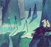
I won't comment too much on the graphics...right now it seems like you have a War Games-esque/computer style graphic. Which I think could work for the map, if you push it further.

I also think the current color scheme could use some rethinking. I'm not sure if anyone else if having a disconnect when trying to match the bonus legend to areas on the map, but I feel like it is taking longer than it should. Maybe experiment with similar regions (all Norway, all Sweden), etc, being gradations of similar colors? Maybe that wouldn't help. But I feel like something can be done here to speed of the recognition process.
I'd also make the islands of Aland and Gotland a little more color distinctive, so there is no question on which bonus zone they belong to.
But on to game play:
Iceland and Northern Norway look strong.
North Sweden may be too strong (at +5). However, this may help people going after it, to combat the strong north (Iceland and Northern Norway, 3 borders for +6). I'd re-look at this area and see how you really want it to be.
Denmark looks like a nice starting point---except that it's expansion possibilities don't look as good as bonus zones in the north. Whoever starts here can't really expand and keep their borders down...they'll keep ending up with 3/4 borders and with minimal bonus gain from Denmark.
Estonia is somewhat similar, though slightly better off because of the near immediate acquisition possibility of grabbing the capital in South Finland. However, expansion from that capital out, and from out of Estonia, looks even worse off compared to Denmark.
Southern Norway, doesn't look like too bad of a start--mostly because the bonus zones near it probably won't have anyone going for them, so they have possibilities of expansion there. But still not great expansion.
Capitals feel like more of a superfluous addition to the map. Someone else mentioned using a couple of other Major Cities I think? Maybe that could help as well.
(P.S. On any map, I usually detest bonus zones with names like "North this" "South that" ---while sometimes helpful for locating an area on the map, they often feel unimaginative. However, such precise/technical names may fit with the "war games" style of graphics if that is developed further.)
--Andy
I won't comment too much on the graphics...right now it seems like you have a War Games-esque/computer style graphic. Which I think could work for the map, if you push it further.
I also think the current color scheme could use some rethinking. I'm not sure if anyone else if having a disconnect when trying to match the bonus legend to areas on the map, but I feel like it is taking longer than it should. Maybe experiment with similar regions (all Norway, all Sweden), etc, being gradations of similar colors? Maybe that wouldn't help. But I feel like something can be done here to speed of the recognition process.
I'd also make the islands of Aland and Gotland a little more color distinctive, so there is no question on which bonus zone they belong to.
But on to game play:
Iceland and Northern Norway look strong.
North Sweden may be too strong (at +5). However, this may help people going after it, to combat the strong north (Iceland and Northern Norway, 3 borders for +6). I'd re-look at this area and see how you really want it to be.
Denmark looks like a nice starting point---except that it's expansion possibilities don't look as good as bonus zones in the north. Whoever starts here can't really expand and keep their borders down...they'll keep ending up with 3/4 borders and with minimal bonus gain from Denmark.
Estonia is somewhat similar, though slightly better off because of the near immediate acquisition possibility of grabbing the capital in South Finland. However, expansion from that capital out, and from out of Estonia, looks even worse off compared to Denmark.
Southern Norway, doesn't look like too bad of a start--mostly because the bonus zones near it probably won't have anyone going for them, so they have possibilities of expansion there. But still not great expansion.
Capitals feel like more of a superfluous addition to the map. Someone else mentioned using a couple of other Major Cities I think? Maybe that could help as well.
(P.S. On any map, I usually detest bonus zones with names like "North this" "South that" ---while sometimes helpful for locating an area on the map, they often feel unimaginative. However, such precise/technical names may fit with the "war games" style of graphics if that is developed further.)
--Andy
-

AndyDufresne
- Posts: 24919
- Joined: Fri Mar 03, 2006 8:22 pm
- Location: A Banana Palm in Zihuatanejo


Re: Northern Europe <v.8> p1,4 - poll
![]() by natty dread on Thu Nov 26, 2009 4:13 pm
by natty dread on Thu Nov 26, 2009 4:13 pm
AndyDufresne wrote:Ahoy!
I won't comment too much on the graphics...right now it seems like you have a War Games-esque/computer style graphic. Which I think could work for the map, if you push it further.
Hmm. Good point, I should think on it.
I also think the current color scheme could use some rethinking. I'm not sure if anyone else if having a disconnect when trying to match the bonus legend to areas on the map, but I feel like it is taking longer than it should. Maybe experiment with similar regions (all Norway, all Sweden), etc, being gradations of similar colors? Maybe that wouldn't help. But I feel like something can be done here to speed of the recognition process.
I'll play around with the colours & see what I can do.
I'd also make the islands of Aland and Gotland a little more color distinctive, so there is no question on which bonus zone they belong to.
Yeah, this has been a major issue. Still is apparently...
Iceland and Northern Norway look strong.
North Sweden may be too strong (at +5). However, this may help people going after it, to combat the strong north (Iceland and Northern Norway, 3 borders for +6). I'd re-look at this area and see how you really want it to be.
The bonuses can be adjusted. How would you distribute the bonuses?
Denmark looks like a nice starting point---except that it's expansion possibilities don't look as good as bonus zones in the north. Whoever starts here can't really expand and keep their borders down...they'll keep ending up with 3/4 borders and with minimal bonus gain from Denmark.
Do you think a connection between denmark and iceland would help it?
Estonia is somewhat similar, though slightly better off because of the near immediate acquisition possibility of grabbing the capital in South Finland. However, expansion from that capital out, and from out of Estonia, looks even worse off compared to Denmark.
Remember, estonia also has direct access to sweden... But yeah I see your point. No idea how to fix it though. Anyway, let's see how the poll goes for Estonia.
Southern Norway, doesn't look like too bad of a start--mostly because the bonus zones near it probably won't have anyone going for them, so they have possibilities of expansion there. But still not great expansion.
Do you have any ideas how to fix this, or if it needs to be fixed?
Capitals feel like more of a superfluous addition to the map. Someone else mentioned using a couple of other Major Cities I think? Maybe that could help as well.
Maybe. As I said in my previous post I'm considering scrapping the interconnected cities ("new classic" style) and replacing them with more standard territories with borders, as several people have wished for this. However I'm not completely sure about it yet, as I quite like the city approach and feel that it fits in the map. What do you think?
Also another idea would be to scrap the +1 autodeploy for the capitals, instead I could add more big cities and make them a collectable bonus (+1 for 3, +2 for 4 and so on...)
(P.S. On any map, I usually detest bonus zones with names like "North this" "South that" ---while sometimes helpful for locating an area on the map, they often feel unimaginative. However, such precise/technical names may fit with the "war games" style of graphics if that is developed further.)
The graphical style may yet change, depending on the public opinion. However this is what we're going with until the map hits the graphics development phase...
Also, all of my map projects have currently been a bit "on hold" as I have been quite occupied with reading the latest Wheel of Time -book. I'm just a fantasy geek in disguise...
Thanks for your comments.
-
natty dread
- Posts: 12877
- Joined: Fri Feb 08, 2008 8:58 pm
- Location: just plain fucked
Re: Northern Europe <v.8> p1,4 - poll
![]() by AndrewB on Thu Nov 26, 2009 4:29 pm
by AndrewB on Thu Nov 26, 2009 4:29 pm
You seem to miss quite a few contries from the Northern Europe:
http://en.wikipedia.org/wiki/Northern_Europe
http://en.wikipedia.org/wiki/Northern_Europe
The United Nations defines Northern Europe as including the following countries and dependent regions:[1][2]
* Denmark
o Faroe Islands
o Greenland
* Estonia
* Finland
o Åland Islands
* Iceland
* Republic of Ireland Ireland
* Latvia
* Lithuania
* Norway
o Norway Svalbard and Jan Mayen
* Sweden
* United Kingdom
o Isle of Man
o United Kingdom Channel Islands: Guernsey and Jersey

-

AndrewB
- Posts: 1814
- Joined: Mon Jun 12, 2006 5:02 pm
- Location: Edmonton, Canada, MST


Re: Northern Europe <v.8> p1,4 - poll
![]() by natty dread on Thu Nov 26, 2009 4:33 pm
by natty dread on Thu Nov 26, 2009 4:33 pm
AndrewB wrote:You seem to miss quite a few contries from the Northern Europe:
http://en.wikipedia.org/wiki/Northern_Europe
The United Nations defines Northern Europe as including the following countries and dependent regions:
Ah, so now the UN is dictating how I should name my maps?
Seriously though, if you feel this way, simply cast your vote on the poll, as option 2 would remove these issues that you bring up.
-
natty dread
- Posts: 12877
- Joined: Fri Feb 08, 2008 8:58 pm
- Location: just plain fucked
Re: Northern Europe <v.8> p1,4 - poll
![]() by Draq on Thu Nov 26, 2009 8:41 pm
by Draq on Thu Nov 26, 2009 8:41 pm
As a Swede I have some suggestions for the Swedish cities and some other stuff. Since you have choosen cities and not regions I think you should stick with that. First of all Gotland is just the name of the island so to make it more consistent you should rename that to Visby, which is the main city on Gotland. Åland should then be named Mariehamn and Saaremaa should be named Kuressaare.
Mora should be replaced by Falun or Borlänge, I would go for Falun cause it's more well known, much larger then Mora and have strong ties to swedish culture and industry (Falukorv, Falu rödfärg). Linköping is a good choice in that region. Arjeplog could be replaced by Arvidsjaur, altough it's almost as tiny as Arjeplog it atleast it's a important railroad junction. I also think Östersund is to far north to be geographicaly correct.
Im also for the skipping estonia part and calling it The Nordic Countries.
Keep up the good work!
- Click image to enlarge.

-

Draq
- Posts: 155
- Joined: Fri Dec 01, 2006 7:17 pm
- Location: Stockholm


Re: Northern Europe <v.8> p1,4 - poll
![]() by Evil DIMwit on Thu Nov 26, 2009 9:09 pm
by Evil DIMwit on Thu Nov 26, 2009 9:09 pm
natty_dread wrote:Denmark looks like a nice starting point---except that it's expansion possibilities don't look as good as bonus zones in the north. Whoever starts here can't really expand and keep their borders down...they'll keep ending up with 3/4 borders and with minimal bonus gain from Denmark.
Do you think a connection between denmark and iceland would help it?
Perhaps a connection from Denmark to Stavangør/Gudvagen, and one from Stavangør/Gudvagen to Iceland. It wrecks S. Norway's holdability but I think that's worth making Denmark and Iceland more open.
natty_dread wrote:Capitals feel like more of a superfluous addition to the map. Someone else mentioned using a couple of other Major Cities I think? Maybe that could help as well.
Maybe. As I said in my previous post I'm considering scrapping the interconnected cities ("new classic" style) and replacing them with more standard territories with borders, as several people have wished for this. However I'm not completely sure about it yet, as I quite like the city approach and feel that it fits in the map. What do you think?
Also another idea would be to scrap the +1 autodeploy for the capitals, instead I could add more big cities and make them a collectable bonus (+1 for 3, +2 for 4 and so on...)
I think anything special you do with the cities is just unnecessary. The map has enough going on without it.


-

Evil DIMwit
- Posts: 1616
- Joined: Thu Mar 22, 2007 1:47 pm
- Location: Philadelphia, NJ


Re: Northern Europe <v.8> p1,4 - poll
![]() by natty dread on Fri Nov 27, 2009 2:17 am
by natty dread on Fri Nov 27, 2009 2:17 am
Draq wrote:As a Swede I have some suggestions for the Swedish cities and some other stuff. Since you have choosen cities and not regions I think you should stick with that. First of all Gotland is just the name of the island so to make it more consistent you should rename that to Visby, which is the main city on Gotland. Åland should then be named Mariehamn and Saaremaa should be named Kuressaare.
Mora should be replaced by Falun or Borlänge, I would go for Falun cause it's more well known, much larger then Mora and have strong ties to swedish culture and industry (Falukorv, Falu rödfärg). Linköping is a good choice in that region. Arjeplog could be replaced by Arvidsjaur, altough it's almost as tiny as Arjeplog it atleast it's a important railroad junction. I also think Östersund is to far north to be geographicaly correct.
Im also for the skipping estonia part and calling it The Nordic Countries.
Keep up the good work!
Thanks! It seems the tide of the poll has turned and I probably will have to do without Estonia. What a shame, I had grown attached to it.
So, adding to the to-do-list:
Lakselv -> Hammerfest
Lillehammar -> Lillehammer
Stavanger -> Bergen
Mosjøen -> Bodø
Kolding -> Vejle
Skien -> Kristiansand
Mora -> Falun
Arjeplog -> Arvidsjaur
Gotland -> Visby
Åland -> Mariehamn
Will try to adjust Östersund.
Now all we needs is a Dane and an Icelander to complain about their cities!
Evil DIMwit wrote:Perhaps a connection from Denmark to Stavangør/Gudvagen, and one from Stavangør/Gudvagen to Iceland. It wrecks S. Norway's holdability but I think that's worth making Denmark and Iceland more open.
That's the thing... I'm not sure if it is worth it. It's already hard to hold northern norway where every territory is a border... Now if you can't hold either there would be not much point in going for Norway.
Evil DIMwit wrote:I think anything special you do with the cities is just unnecessary. The map has enough going on without it.
True. Now I just need to figure out which cities would deserve to be made "capitals but not capitals"... Preferably I'd like to use major cities in northern Norway, Sweden and Finland which don't yet have "capitals". Then of course I would call them something else than capitals...
-
natty dread
- Posts: 12877
- Joined: Fri Feb 08, 2008 8:58 pm
- Location: just plain fucked
Re: Northern Europe <v.8> p1,4 - poll
![]() by captainwalrus on Fri Nov 27, 2009 2:42 pm
by captainwalrus on Fri Nov 27, 2009 2:42 pm
Which is the most recent version?
I like
this one best, texture wise, but that doesn't seem to be on the first post.
I like
- Click image to enlarge.

this one best, texture wise, but that doesn't seem to be on the first post.
~ CaptainWalrus
-
captainwalrus
- Posts: 1018
- Joined: Sun Nov 11, 2007 3:19 pm
- Location: Finnmark

Re: Northern Europe <v.8> p1,4 - poll
![]() by natty dread on Fri Nov 27, 2009 3:21 pm
by natty dread on Fri Nov 27, 2009 3:21 pm
I haven't updated it on the first post, since it wasn't yet decided which version to use.
However I'll be making an update soon with major changes. Stay tuned...
However I'll be making an update soon with major changes. Stay tuned...
-
natty dread
- Posts: 12877
- Joined: Fri Feb 08, 2008 8:58 pm
- Location: just plain fucked
Re: Nordic countries v10
![]() by natty dread on Fri Nov 27, 2009 6:29 pm
by natty dread on Fri Nov 27, 2009 6:29 pm
Version 10 of the map formerly known as "northern europe":
Scrapped Estonia. Renamed map Nordic Countries.
Many cities changed. Many city connections changed.
New legend. New colours. New texture.
Now with 25% more strategy!
- Click image to enlarge.

Scrapped Estonia. Renamed map Nordic Countries.
Many cities changed. Many city connections changed.
New legend. New colours. New texture.
Now with 25% more strategy!
-
natty dread
- Posts: 12877
- Joined: Fri Feb 08, 2008 8:58 pm
- Location: just plain fucked
Re: Nordic Countries <v.10> Major update! p1,4
![]() by AndyDufresne on Fri Nov 27, 2009 7:33 pm
by AndyDufresne on Fri Nov 27, 2009 7:33 pm
Why not give this map the look...as if it is displayed on an old computer screen? I.E. give it a frame around the map that could signify/showcase that? Play up that theme, if you are going to keep it.
--Andy
--Andy
-
AndyDufresne
- Posts: 24919
- Joined: Fri Mar 03, 2006 8:22 pm
- Location: A Banana Palm in Zihuatanejo
Re: Nordic Countries <v.10> Major update! p1,4
![]() by natty dread on Fri Nov 27, 2009 8:45 pm
by natty dread on Fri Nov 27, 2009 8:45 pm
Umm... otherwise a passable idea, but the shape of the map wouldn't lend itself well to that. Unless the monitor was turned on it's side.
Anyway, how do you like the changes?
Anyway, how do you like the changes?
-
natty dread
- Posts: 12877
- Joined: Fri Feb 08, 2008 8:58 pm
- Location: just plain fucked
Re: Nordic Countries <v.10> Major update! p1,4
![]() by natty dread on Fri Nov 27, 2009 10:32 pm
by natty dread on Fri Nov 27, 2009 10:32 pm
Well, I just couldn't stop there. I'll just call this version 11. I'm on a roll...
- Click image to enlarge.

-
natty dread
- Posts: 12877
- Joined: Fri Feb 08, 2008 8:58 pm
- Location: just plain fucked
Re: Nordic Countries <v.11> Major update! p1,4
![]() by isaiah40 on Fri Nov 27, 2009 10:35 pm
by isaiah40 on Fri Nov 27, 2009 10:35 pm
Drop those dotted lines, it messes up the map. I like the original lines better!
-
isaiah40
- Posts: 3990
- Joined: Mon Aug 27, 2007 7:14 pm


Re: Nordic Countries <v.11> Major update! p1,4
![]() by captainwalrus on Fri Nov 27, 2009 10:37 pm
by captainwalrus on Fri Nov 27, 2009 10:37 pm
yeah, and some of the color combinations are odd. why not just kep the solidish coloors?
~ CaptainWalrus
-
captainwalrus
- Posts: 1018
- Joined: Sun Nov 11, 2007 3:19 pm
- Location: Finnmark
Re: Nordic Countries <v.11> Major update! p1,4
![]() by natty dread on Fri Nov 27, 2009 10:45 pm
by natty dread on Fri Nov 27, 2009 10:45 pm
Well, someone suggested gradients for the bonus areas, and I thought why not. It's not done in very many maps. But meh... I kinda like the gradients, I can change the colours though... Now that the legend is graphic, it doesn't matter if you can tell the continents apart, as long as you see where one ends and one begins...
How do you like the new legend? Is it clear enough, particularly on the superbonuses? Do you "get" it? I didn't have space to put it in text, so I came up with this solution with the arrows...
Hmm. I thought the dotted lines would have been better than solid, since so many people didn't like the lines-and-circles approach... I guess I'll go back to the old lines, but modify them a bit.
-
natty dread
- Posts: 12877
- Joined: Fri Feb 08, 2008 8:58 pm
- Location: just plain fucked
Re: Nordic Countries <v.12> Major update! p1,7
![]() by natty dread on Sat Nov 28, 2009 11:54 am
by natty dread on Sat Nov 28, 2009 11:54 am
Version 12
Went back to the solid lines between cities. Changed colour scheme. Added a gradient mask to one of the ocean layers. Added country names to minimap.
- Click image to enlarge.

Went back to the solid lines between cities. Changed colour scheme. Added a gradient mask to one of the ocean layers. Added country names to minimap.
-
natty dread
- Posts: 12877
- Joined: Fri Feb 08, 2008 8:58 pm
- Location: just plain fucked
Re: Nordic Countries <v.11> Major update! p1,6
![]() by Industrial Helix on Sat Nov 28, 2009 12:11 pm
by Industrial Helix on Sat Nov 28, 2009 12:11 pm
Alright, like everyone, I want a Scandanavia map to conquer on ect. So I really hope this map turns out well.
Most of crits are graphics but there is a gameplay in there as well.
First off... If you've read my post on Hijrah, I hate cities with lines connecting. I want to conquer large swaths of land and establish my cold, arctic empire. Cities are unrealistic, what about the partisans in the mountains? Is this a light occupation or a full occupation!?! But jokes aside, I prefer the visual recognition of captured territories with continuous borders rather the three lines in. It's just too hard for me to play and recognize what it is I'm doing. Quite simply, I probably wouldn't play this map if the territories were cities.
Plus, the title is Nordic countries and not Nordic cities, so if you insist on pursuing the ball and stick approach, change the name at least.
The name also implies that there are nation-states involved here but, for the sake of bonuses, I count eight instead of five. I understand the need for smaller bonus regions and agree, it needs to be broken up. But the graphics could go a long way to make it seem as if South Finland and North Finland are actually part of the same country. Make Finland two shades of white with blue writing. Make Sweden two shades of light blue with gold writing, ect. Add some theme into this map and it will go a long way.
Lastly, what's with the Nintendo Graphics? Blocky pixel letters and harsh connection lines? Go Viking or something, most especially in font.
http://www.castlesncrypts.com/fonts-viking.shtml for example
And the one thing I don't liek about this map's gameplay is the lack of mountains. For whatever reason, I think of Nordic as cold, snowy and mountains. Whereas everything's kind of cool disco colors and at best, the connection lines could be interpreted as snow footprints or something.
But I want the gameplay of the map to reflect the terrain of the Nordic Countries and I think this would be appropriate for a map like this.
Anyway, I think you've got the skills to pull this off. Good luck, we need a Scandinavia/Nordic map.
EDIT... you made some change while I posted
Finland looks good, though losing the green would be best. Norway looks good too, except lose the yellow and go with either blue or white. I think my comments ont he font still stands and the sea lanes are a little blocky as well. You changed the city connections, but again, please go for territories.
Sketchblog [Update 07/25/11]: http://indyhelixsketch.blogspot.com/
Living in Japan [Update 07/17/11]: http://mirrorcountryih.blogspot.com/
Russian Revolution map for ConquerClub [07/20/11]: viewtopic.php?f=241&t=116575
Living in Japan [Update 07/17/11]: http://mirrorcountryih.blogspot.com/
Russian Revolution map for ConquerClub [07/20/11]: viewtopic.php?f=241&t=116575
-

Industrial Helix
- Posts: 3462
- Joined: Mon Jul 14, 2008 6:49 pm
- Location: Ohio


Re: Nordic Countries <v.11> Major update! p1,6
![]() by natty dread on Sat Nov 28, 2009 12:49 pm
by natty dread on Sat Nov 28, 2009 12:49 pm
First of all, thanks for your long post. I'll try to answer in detail...
So, you won't be playing the new classic map either?
Have to disagree here. Nordic countries describes the area that the map represents precisely. Nordic cities, what does that even mean? It just sounds bad.
Viking? I see only three viking countries here. There is a theme on the map, the theme is nordic countries. And quite frankly, IMO that's all the theme a basic geographical map needs... Does Netherlands have a theme? Does Luxembourg have a theme? To mention two quite popular maps, which don't seem to have any theme whatsoever.
As for the "Nintendo graphics", Andy said a couple updates back that the graphical style reminded him of Wargames (the movie). And suggested that I pursue that graphical style, as he thought it could work for the map. Now you say you don't like the style. Can't please everyone I guess...
As for the Viking theme, it wouldn't be accurate to the area of the map. There's Sweden and Finland, two major countries of this map, which have nothing to do with Vikings. Well, maybe Sweden, but not to the extent that Norway, Iceland and Denmark do. I want this map to represent all of the Nordic countries, not just half of them.
There's only one mountain range, between Norway and Sweden. This is already represented in the map in a way, by the lack of connections between the cities of Northern Norway & Sweden. However I do intend to put those mountains in there at some point. As soon as I manage to draw a mountain range that I like, and that fits the map's style.
But I want the gameplay of the map to reflect the terrain of the Nordic Countries and I think this would be appropriate for a map like this.
Thanks, I'm doing my best.
I have been considering going with territories instead of cities. There are a few problems though...
First of all, how would I divide the countries into territories? Would the territories still be cities, or regions of the countries? Or both? There would have to be some consistency into the naming of the territories.
If I was to use cities, how would I decide the borders of the territories? Would I use borders of regions where the cities are? What if there's 2 or more cities in the same region?
If I was to use the regions themselves, well, there's still problems. For example, Finland doesn't have enough regions, particularly in northern finland. All of Northern Finland which is now 4 cities would become 1 huge territory...
When I started designing this map, I took a long look at the regions of each country. Then I took a long look at the cities of each country and decided that going with the cities would be easier.
I have no objections about using territories, if it comes to that, but these issues need to be resolved somehow, first.
Anyway, thanks for your feedback. I will make a note of all the issues you have raised, and try to figure a way to address these issues in the next update.
Industrial Helix wrote:Alright, like everyone, I want a Scandanavia map to conquer on ect. So I really hope this map turns out well.
Most of crits are graphics but there is a gameplay in there as well.
First off... If you've read my post on Hijrah, I hate cities with lines connecting. I want to conquer large swaths of land and establish my cold, arctic empire. Cities are unrealistic, what about the partisans in the mountains? Is this a light occupation or a full occupation!?! But jokes aside, I prefer the visual recognition of captured territories with continuous borders rather the three lines in. It's just too hard for me to play and recognize what it is I'm doing. Quite simply, I probably wouldn't play this map if the territories were cities.
So, you won't be playing the new classic map either?
Plus, the title is Nordic countries and not Nordic cities, so if you insist on pursuing the ball and stick approach, change the name at least.
Have to disagree here. Nordic countries describes the area that the map represents precisely. Nordic cities, what does that even mean? It just sounds bad.
The name also implies that there are nation-states involved here but, for the sake of bonuses, I count eight instead of five. I understand the need for smaller bonus regions and agree, it needs to be broken up. But the graphics could go a long way to make it seem as if South Finland and North Finland are actually part of the same country. Make Finland two shades of white with blue writing. Make Sweden two shades of light blue with gold writing, ect. Add some theme into this map and it will go a long way.
Lastly, what's with the Nintendo Graphics? Blocky pixel letters and harsh connection lines? Go Viking or something, most especially in font.
Viking? I see only three viking countries here. There is a theme on the map, the theme is nordic countries. And quite frankly, IMO that's all the theme a basic geographical map needs... Does Netherlands have a theme? Does Luxembourg have a theme? To mention two quite popular maps, which don't seem to have any theme whatsoever.
As for the "Nintendo graphics", Andy said a couple updates back that the graphical style reminded him of Wargames (the movie). And suggested that I pursue that graphical style, as he thought it could work for the map. Now you say you don't like the style. Can't please everyone I guess...
As for the Viking theme, it wouldn't be accurate to the area of the map. There's Sweden and Finland, two major countries of this map, which have nothing to do with Vikings. Well, maybe Sweden, but not to the extent that Norway, Iceland and Denmark do. I want this map to represent all of the Nordic countries, not just half of them.
And the one thing I don't liek about this map's gameplay is the lack of mountains. For whatever reason, I think of Nordic as cold, snowy and mountains. Whereas everything's kind of cool disco colors and at best, the connection lines could be interpreted as snow footprints or something.
There's only one mountain range, between Norway and Sweden. This is already represented in the map in a way, by the lack of connections between the cities of Northern Norway & Sweden. However I do intend to put those mountains in there at some point. As soon as I manage to draw a mountain range that I like, and that fits the map's style.
But I want the gameplay of the map to reflect the terrain of the Nordic Countries and I think this would be appropriate for a map like this.
Anyway, I think you've got the skills to pull this off. Good luck, we need a Scandinavia/Nordic map.
Thanks, I'm doing my best.
EDIT... you made some change while I posted
Finland looks good, though losing the green would be best. Norway looks good too, except lose the yellow and go with either blue or white. I think my comments ont he font still stands and the sea lanes are a little blocky as well. You changed the city connections, but again, please go for territories.
I have been considering going with territories instead of cities. There are a few problems though...
First of all, how would I divide the countries into territories? Would the territories still be cities, or regions of the countries? Or both? There would have to be some consistency into the naming of the territories.
If I was to use cities, how would I decide the borders of the territories? Would I use borders of regions where the cities are? What if there's 2 or more cities in the same region?
If I was to use the regions themselves, well, there's still problems. For example, Finland doesn't have enough regions, particularly in northern finland. All of Northern Finland which is now 4 cities would become 1 huge territory...
When I started designing this map, I took a long look at the regions of each country. Then I took a long look at the cities of each country and decided that going with the cities would be easier.
I have no objections about using territories, if it comes to that, but these issues need to be resolved somehow, first.
Anyway, thanks for your feedback. I will make a note of all the issues you have raised, and try to figure a way to address these issues in the next update.
-
natty dread
- Posts: 12877
- Joined: Fri Feb 08, 2008 8:58 pm
- Location: just plain fucked
Re: Nordic Countries <v.12> Major update! p1,7
![]() by RedBaron0 on Sat Nov 28, 2009 1:05 pm
by RedBaron0 on Sat Nov 28, 2009 1:05 pm
Poll Results:
======================================================================
Poll: What to do with Estonia
-Keep it----------------------------------------------------------------------------------7....32%
-Remove it and rename the map "Nordic Countries"---------------------------10...45%
-Who cares, this map is crap anyway and you should stop development ASAP--5....23%
======================================================================
Total votes : 22
======================================================================
Poll: What to do with Estonia
-Keep it----------------------------------------------------------------------------------7....32%
-Remove it and rename the map "Nordic Countries"---------------------------10...45%
-Who cares, this map is crap anyway and you should stop development ASAP--5....23%
======================================================================
Total votes : 22


-

RedBaron0
- Posts: 2657
- Joined: Sun Aug 19, 2007 12:59 pm
- Location: Pennsylvania


Re: Nordic Countries <v.12> Major update! p1,7
![]() by Industrial Helix on Sat Nov 28, 2009 4:03 pm
by Industrial Helix on Sat Nov 28, 2009 4:03 pm
As for the classic map, Eh... I'm already hesitant to play it whenever it comes out. I really don't like lines. Classic Art will probably be my classic map of choice.
Nordic cities, you are using cities, yes? I read country as either a nation-state or country as in geographic area. If you plan to go ahead with cities, I think naming it Nordic Countries would be inaccurate.
As for Vikings, google images for Viking Countries maps tells me Norway is included somewhere with Sweden, so is Finland and Iceland reads something like a Nordic/Viking Colony. Wikipedia informs me Norway does in fact fall under Viking settled areas, however, Finland is labeled an area heavily raided.
http://en.wikipedia.org/wiki/File:Viking_Expansion.svg
Finland and parts of Norway were all part of the Kingdom/Empire of Sweden during the early modern era... Interestingly enough so was Estonia... it's a long shot but consider doing a historical Empire of Sweden map?
While Luxembourg and Netherlands do not have a "theme" they have very strong graphical cohesion as Netherlands relies heavily on the flag and Luxembourg uses a winning palette of blue hues. No, there isn't a theme per se, but it has all the cohesion of its own theme. I think this map, at this stage, does not have this.
You don't have to go for a Viking theme but I think you should use fonts and colors indicative of the countries, nations and culture being represented. You may be echoing Wargames the movie, but I have no idea what that is and apparently its reach is not as universal as Scandinavian culture.
As for the territories, keep the same gameplay cause you've already got it worked out. Just draw in territories that match it. If north Finland has 4 cities then break that down into four territories and keep the names.
I drew some quick territories on this map... the only connection i couldn't figure out is Arvisjaur and Umea... which if there's no mountains there I don't see how they couldn't attack each other.
- Click image to enlarge.

Sketchblog [Update 07/25/11]: http://indyhelixsketch.blogspot.com/
Living in Japan [Update 07/17/11]: http://mirrorcountryih.blogspot.com/
Russian Revolution map for ConquerClub [07/20/11]: viewtopic.php?f=241&t=116575
Living in Japan [Update 07/17/11]: http://mirrorcountryih.blogspot.com/
Russian Revolution map for ConquerClub [07/20/11]: viewtopic.php?f=241&t=116575
-
Industrial Helix
- Posts: 3462
- Joined: Mon Jul 14, 2008 6:49 pm
- Location: Ohio
Re: Nordic Countries <v.12> Major update! p1,7
![]() by natty dread on Sat Nov 28, 2009 4:26 pm
by natty dread on Sat Nov 28, 2009 4:26 pm
Industrial Helix wrote:As for the classic map, Eh... I'm already hesitant to play it whenever it comes out. I really don't like lines. Classic Art will probably be my classic map of choice.
Eh... yeah. Well, these are personal preferences, as if you look at the new classic map there are tons of people who are going to play it, despite it not having conventional territories.
Personally, I like the interconnected cities approach, somehow, for me, it's even easier to figure out than territories with borders.
Nordic cities, you are using cities, yes? I read country as either a nation-state or country as in geographic area. If you plan to go ahead with cities, I think naming it Nordic Countries would be inaccurate.
As for Vikings, google images for Viking Countries maps tells me Norway is included somewhere with Sweden, so is Finland and Iceland reads something like a Nordic/Viking Colony. Wikipedia informs me Norway does in fact fall under Viking settled areas, however, Finland is labeled an area heavily raided.
http://en.wikipedia.org/wiki/File:Viking_Expansion.svg
Finland and parts of Norway were all part of the Kingdom/Empire of Sweden during the early modern era... Interestingly enough so was Estonia... it's a long shot but consider doing a historical Empire of Sweden map?
Well... While a historical Empire of Sweden -map would be great, it is not what I'm going for with this map. This map is not a historical map, this is a modern map... I think changing it now into a historical map would be too dramatic.
As for Estonia... aaargh! I just got rid of Estonia, when the majority of people were telling me that Estonia doesn't fit in to the map.
Perhaps, though... if this map stalls like my first project, I could turn this into a historical project... time will tell.
While Luxembourg and Netherlands do not have a "theme" they have very strong graphical cohesion as Netherlands relies heavily on the flag and Luxembourg uses a winning palette of blue hues. No, there isn't a theme per se, but it has all the cohesion of its own theme. I think this map, at this stage, does not have this.
You're quite right, and while I was out buying food & cigarettes (nasty habit, that) I had a few ideas on how to fix this. Wait and see...
As for the territories, keep the same gameplay cause you've already got it worked out. Just draw in territories that match it. If north Finland has 4 cities then break that down into four territories and keep the names.
I drew some quick territories on this map... the only connection i couldn't figure out is Arvisjaur and Umea... which if there's no mountains there I don't see how they couldn't attack each other.
You're right about Arvidsjaur and Umeå, they should be connected. The connection seems to have slipped my mind...
- Click image to enlarge.
The only problem I can see with this is that these borders are not accurate, they do not represent any real city or region borders. Do you not think I would be hearing about it, particularly from the Swedes and Norwegians who already complain if the wrong cities are on the map?
No, I'm afraid that if I'm going to go with the territory & borders approach, I will have to come up with something creative. I have a plan for this, which also came to me while I was outside... nothing like fresh air to get those brain cells moving.
-
natty dread
- Posts: 12877
- Joined: Fri Feb 08, 2008 8:58 pm
- Location: just plain fucked
Who is online
Users browsing this forum: No registered users
|
|||||||
| Conquer Club is not associated with RISK online in any way. Copyright © 2006-2024 by Big Wham LLC | |||||||