Looking really good. I am excited to play it.
One more minor suggestion
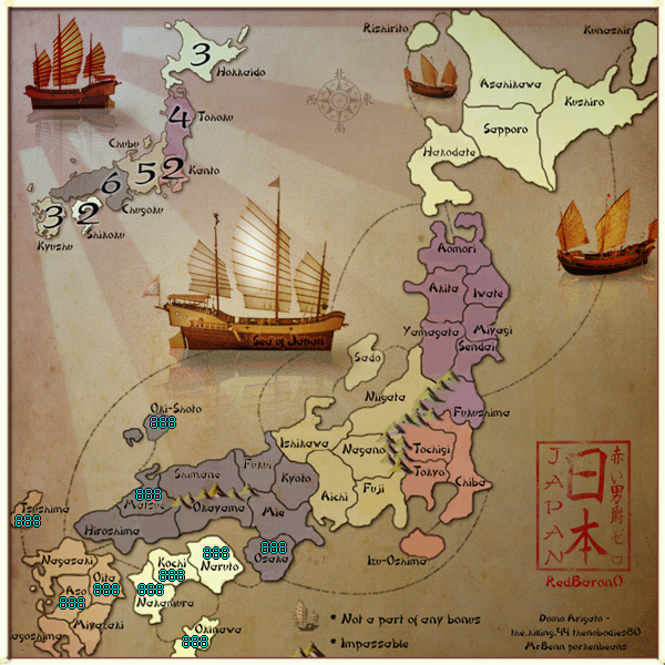
Oita might be moved a little to the right. the font makes the O mimic the border and could be confusing for those with bad eyesight.
Can't wait to drop some numbers on this!
Japan - 日本 - Quenched
Moderator: Cartographers
Re: Japan - 日本 (D, Gp, Gr) V14.0 XML checked ready to go
![]() by Mad-elph on Fri Jan 29, 2010 4:27 pm
by Mad-elph on Fri Jan 29, 2010 4:27 pm
-

 Mad-elph
- Posts: 52
- Joined: Fri Apr 11, 2008 12:48 am
- Location: Canada


Re: Japan - 日本 (D, Gp, Gr) V14.0 XML checked ready to go
![]() by Industrial Helix on Fri Jan 29, 2010 5:57 pm
by Industrial Helix on Fri Jan 29, 2010 5:57 pm
Looks pretty solid to me. The sea of Japan numbers not being on the ship seems a tad unusual, but its just a quirk. I don't recommend changing it.
Sketchblog [Update 07/25/11]: http://indyhelixsketch.blogspot.com/
Living in Japan [Update 07/17/11]: http://mirrorcountryih.blogspot.com/
Russian Revolution map for ConquerClub [07/20/11]: viewtopic.php?f=241&t=116575
Living in Japan [Update 07/17/11]: http://mirrorcountryih.blogspot.com/
Russian Revolution map for ConquerClub [07/20/11]: viewtopic.php?f=241&t=116575
-

Industrial Helix
- Posts: 3462
- Joined: Mon Jul 14, 2008 6:49 pm
- Location: Ohio


Re: Japan - 日本 (D, Gp, Gr) V14.0 XML checked ready to go
![]() by natty dread on Fri Jan 29, 2010 7:52 pm
by natty dread on Fri Jan 29, 2010 7:52 pm
Everything seems good now!
β it!

β it!

-

natty dread
- Posts: 12877
- Joined: Fri Feb 08, 2008 8:58 pm
- Location: just plain fucked


Re: Japan - 日本 (D, Gp, Gr) V14.0 XML checked ready to go
![]() by RedBaron0 on Sat Jan 30, 2010 3:34 am
by RedBaron0 on Sat Jan 30, 2010 3:34 am
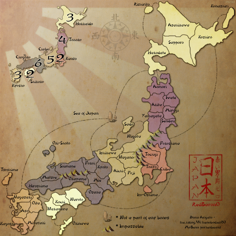
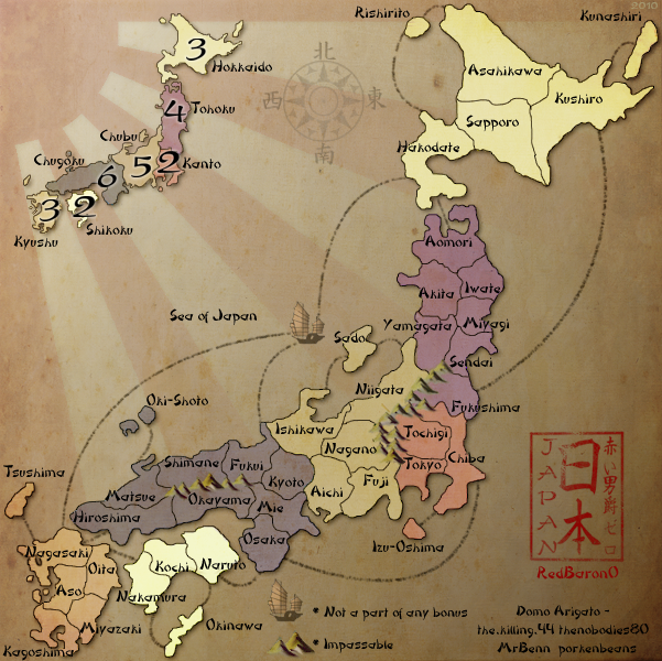
Oita name moved slightly on both maps
Big:
Small:
Big:
- Click image to enlarge.
Small:
- Click image to enlarge.


-

RedBaron0
- Posts: 2657
- Joined: Sun Aug 19, 2007 12:59 pm
- Location: Pennsylvania


Re: Japan - 日本 (D, Gp, Gr) V14.0 XML checked ready to go
![]() by Mad-elph on Sat Jan 30, 2010 12:35 pm
by Mad-elph on Sat Jan 30, 2010 12:35 pm
RedBaron0 wrote:Oita name moved slightly on both maps
Beautiful.. I agree Beta it
-
Mad-elph
- Posts: 52
- Joined: Fri Apr 11, 2008 12:48 am
- Location: Canada
Re: Japan - 日本 (D, Gp, Gr) V14.0 XML checked ready to go
![]() by porkenbeans on Sat Jan 30, 2010 4:51 pm
by porkenbeans on Sat Jan 30, 2010 4:51 pm
I wanted to give my input on the coordinates of the names and numbers. And, as usual I seem to work better with illustrations, instead of words. Besides, I just love to play, and learn in Photoshop.
Thinking about the subject, and how it IS a Japan map, I thought that I would take from what I know about Fung-Shwa, and utilize it for this task. Take notice of how the relationships between the names and numbers, are all pretty much the same. Also, their relationship to their prospective territories, are as well. This kind of uniformity is very prevalent in the Japanese art of Fung-Shwa. Ya gotta hand it to them for the meticulous and exacting standards that they incorporate into just about everything they do.
The examples below are meant to show my suggs for the placements of the names and numbers. I enlarged an island or two, for obvious reasons.
The changes to the compass, and the Junk is just me farting around, and having fun. I wanted to show your Junk as the center focus area, and Your image was too pixilated after I enlarged it, so I just used a (stand-in) to show how your ship would look, with all that wonderful detail as the center focus.
Anyway, I hope that you will see something that you can use, and lets all push to see this map go live.
- Click image to enlarge.
- Click image to enlarge.

-

porkenbeans
- Posts: 2546
- Joined: Mon Sep 10, 2007 4:06 pm


Re: Japan - 日本 (D, Gp, Gr) V14.0 XML checked ready to go
![]() by the.killing.44 on Sat Jan 30, 2010 6:19 pm
by the.killing.44 on Sat Jan 30, 2010 6:19 pm
Don't change a thing, RB0
-

the.killing.44
- Posts: 4724
- Joined: Thu Oct 23, 2008 7:43 pm
- Location: now tell me what got two gums and knows how to spit rhymes


Re: Japan - 日本 (D, Gp, Gr) V14.0 XML checked ready to go
![]() by porkenbeans on Sat Jan 30, 2010 6:22 pm
by porkenbeans on Sat Jan 30, 2010 6:22 pm
Thanx alot 44. 
-
porkenbeans
- Posts: 2546
- Joined: Mon Sep 10, 2007 4:06 pm
Re: Japan - 日本 (D, Gp, Gr) V14.0 XML checked ready to go
![]() by the.killing.44 on Sat Jan 30, 2010 6:28 pm
by the.killing.44 on Sat Jan 30, 2010 6:28 pm
porkenbeans wrote:Thanx alot 44.
It's just too much too late.
-
the.killing.44
- Posts: 4724
- Joined: Thu Oct 23, 2008 7:43 pm
- Location: now tell me what got two gums and knows how to spit rhymes
Re: Japan - 日本 (D, Gp, Gr) V14.0 XML checked ready to go
![]() by Industrial Helix on Sat Jan 30, 2010 6:39 pm
by Industrial Helix on Sat Jan 30, 2010 6:39 pm
I wouldn't make any graphics changes, the coordinates fit fine on the current map and there is no reason why the sea of Japan needs to be represented by a dreadnought in a puddle ... but I think there is something to be said about the location of the coordinates. I wasn't going to say anything because, honestly, it doesn't bug me and it works either way. It's not a matter of clarity but rather preference. Your call Red.
Sketchblog [Update 07/25/11]: http://indyhelixsketch.blogspot.com/
Living in Japan [Update 07/17/11]: http://mirrorcountryih.blogspot.com/
Russian Revolution map for ConquerClub [07/20/11]: viewtopic.php?f=241&t=116575
Living in Japan [Update 07/17/11]: http://mirrorcountryih.blogspot.com/
Russian Revolution map for ConquerClub [07/20/11]: viewtopic.php?f=241&t=116575
-
Industrial Helix
- Posts: 3462
- Joined: Mon Jul 14, 2008 6:49 pm
- Location: Ohio
Re: Japan - 日本 (D, Gp, Gr) V14.0 XML checked ready to go
![]() by porkenbeans on Sat Jan 30, 2010 7:13 pm
by porkenbeans on Sat Jan 30, 2010 7:13 pm
Yes, the coordinates is the main sugg. The rest is just Photoshop playfulness.Industrial Helix wrote:I wouldn't make any graphics changes, the coordinates fit fine on the current map and there is no reason why the sea of Japan needs to be represented by a dreadnought in a puddle ... but I think there is something to be said about the location of the coordinates. I wasn't going to say anything because, honestly, it doesn't bug me and it works either way. It's not a matter of clarity but rather preference. Your call Red.
-
porkenbeans
- Posts: 2546
- Joined: Mon Sep 10, 2007 4:06 pm
Re: Japan - 日本 (D, Gp, Gr) V14.0 XML checked ready to go
![]() by the.killing.44 on Sat Jan 30, 2010 7:21 pm
by the.killing.44 on Sat Jan 30, 2010 7:21 pm
porkenbeans wrote:Yes, the coordinates is the main sugg. The rest is just Photoshop playfulness.Industrial Helix wrote:I wouldn't make any graphics changes, the coordinates fit fine on the current map and there is no reason why the sea of Japan needs to be represented by a dreadnought in a puddle ... but I think there is something to be said about the location of the coordinates. I wasn't going to say anything because, honestly, it doesn't bug me and it works either way. It's not a matter of clarity but rather preference. Your call Red.
coord changes I could get behind.
-
the.killing.44
- Posts: 4724
- Joined: Thu Oct 23, 2008 7:43 pm
- Location: now tell me what got two gums and knows how to spit rhymes
Re: Japan - 日本 (D, Gp, Gr) V14.0 XML checked ready to go
![]() by ender516 on Sun Jan 31, 2010 1:17 am
by ender516 on Sun Jan 31, 2010 1:17 am
the.killing.44 wrote:porkenbeans wrote:Yes, the coordinates is the main sugg. The rest is just Photoshop playfulness.Industrial Helix wrote:I wouldn't make any graphics changes, the coordinates fit fine on the current map and there is no reason why the sea of Japan needs to be represented by a dreadnought in a puddle ... but I think there is something to be said about the location of the coordinates. I wasn't going to say anything because, honestly, it doesn't bug me and it works either way. It's not a matter of clarity but rather preference. Your call Red.
coord changes I could get behind.
I, too, think a lot of the coordinate changes look good, but I wonder how many of them would work on the small map. Currently the small map is working using what looks like the same size text as the large, and I know porkenbeans and I both appreciate text that is not too small. So the question is, would having the labels in different locations on the large and small maps cause confusion?
-

ender516
- Posts: 4455
- Joined: Wed Dec 17, 2008 6:07 pm
- Location: Waterloo, Ontario


Re: Japan - 日本 (D, Gp, Gr) V14.0 XML checked ready to go
![]() by RedBaron0 on Sun Jan 31, 2010 1:42 am
by RedBaron0 on Sun Jan 31, 2010 1:42 am
There are a couple like that anyways, I just don't want to have a lot of the coordinates be different between large and small map.
Just to be clear. Is the suggestion(in general) to move, where possible, coordinates(or the name of the territory) closer together?
Just to be clear. Is the suggestion(in general) to move, where possible, coordinates(or the name of the territory) closer together?
-
RedBaron0
- Posts: 2657
- Joined: Sun Aug 19, 2007 12:59 pm
- Location: Pennsylvania
Re: Japan - 日本 (D, Gp, Gr) V14.0 XML checked ready to go
![]() by jefjef on Sun Jan 31, 2010 3:53 am
by jefjef on Sun Jan 31, 2010 3:53 am
Gee porken. Why didn't ya just use a freaking aircraft carrier? It could be worth 5 bonus.
RBO as far as I'm concerned yours was good to go with a couple tweeks already mentioned. But the coordinate positioning pb did looks good.
RBO as far as I'm concerned yours was good to go with a couple tweeks already mentioned. But the coordinate positioning pb did looks good.
This post was made by jefjef who should be on your ignore list.

drunkmonkey wrote:I'm filing a C&A report right now. Its nice because they have a drop-down for "jefjef".
-

jefjef
- Posts: 6026
- Joined: Mon Feb 23, 2009 8:41 pm
- Location: on my ass


Re: Japan - 日本 (D, Gp, Gr) V14.0 XML checked ready to go
![]() by porkenbeans on Sun Jan 31, 2010 6:49 am
by porkenbeans on Sun Jan 31, 2010 6:49 am
ender,ender516 wrote:the.killing.44 wrote:porkenbeans wrote:Yes, the coordinates is the main sugg. The rest is just Photoshop playfulness.Industrial Helix wrote:I wouldn't make any graphics changes, the coordinates fit fine on the current map and there is no reason why the sea of Japan needs to be represented by a dreadnought in a puddle ... but I think there is something to be said about the location of the coordinates. I wasn't going to say anything because, honestly, it doesn't bug me and it works either way. It's not a matter of clarity but rather preference. Your call Red.
coord changes I could get behind.
I, too, think a lot of the coordinate changes look good, but I wonder how many of them would work on the small map. Currently the small map is working using what looks like the same size text as the large, and I know porkenbeans and I both appreciate text that is not too small. So the question is, would having the labels in different locations on the large and small maps cause confusion?
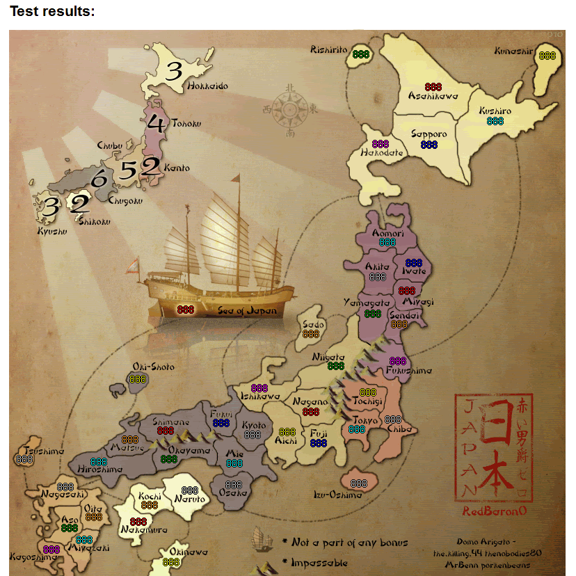
here it is at 90%, small enough for the small version. I threw up some numbers on some of the smallest territs. It looks to me that they will work fine matched up to the alt. coords.
Gee porken. Why didn't ya just use a freaking aircraft carrier? It could be worth 5 bonus.
RBO as far as I'm concerned yours was good to go with a couple tweeks already mentioned. But the coordinate positioning pb did looks good.
Well, how about two or three more and make then an additional bonus area.
- Click image to enlarge.
-
porkenbeans
- Posts: 2546
- Joined: Mon Sep 10, 2007 4:06 pm
Re: Japan - 日本 (D, Gp, Gr) V14.0 XML checked ready to go
![]() by porkenbeans on Sun Jan 31, 2010 7:04 am
by porkenbeans on Sun Jan 31, 2010 7:04 am
Hey red,RedBaron0 wrote:There are a couple like that anyways, I just don't want to have a lot of the coordinates be different between large and small map.
Just to be clear. Is the suggestion(in general) to move, where possible, coordinates(or the name of the territory) closer together?
check out the animation gif that I put up. If you study each territ you will see where I redrew some borders. Fix that on your file to match, then you could overlay my coords, then just move your names and numbers to match over the top of my cords. Then trash my cords, and you will have it.
-
porkenbeans
- Posts: 2546
- Joined: Mon Sep 10, 2007 4:06 pm
Re: Japan - 日本 (D, Gp, Gr) V14.0 XML checked ready to go
![]() by natty dread on Sun Jan 31, 2010 8:49 am
by natty dread on Sun Jan 31, 2010 8:49 am
the question is, would having the labels in different locations on the large and small maps cause confusion?
I don't think so. Usually people use either the small map or the large map, not both maps together, so they don't need to be all that consistent with each other.
Pork's coordinates seem a good idea to me, but I'm not so sure on enlargening the islands... it seems unnecessary on most places. And some Japanese guy is surely going to complain if the land areas are not accurate...
-
natty dread
- Posts: 12877
- Joined: Fri Feb 08, 2008 8:58 pm
- Location: just plain fucked
Re: Japan - 日本 (D, Gp, Gr) V14.0 XML checked ready to go
![]() by Industrial Helix on Sun Jan 31, 2010 10:16 am
by Industrial Helix on Sun Jan 31, 2010 10:16 am
Yes... do not enlarge the islands.
Sketchblog [Update 07/25/11]: http://indyhelixsketch.blogspot.com/
Living in Japan [Update 07/17/11]: http://mirrorcountryih.blogspot.com/
Russian Revolution map for ConquerClub [07/20/11]: viewtopic.php?f=241&t=116575
Living in Japan [Update 07/17/11]: http://mirrorcountryih.blogspot.com/
Russian Revolution map for ConquerClub [07/20/11]: viewtopic.php?f=241&t=116575
-
Industrial Helix
- Posts: 3462
- Joined: Mon Jul 14, 2008 6:49 pm
- Location: Ohio
Re: Japan - 日本 (D, Gp, Gr) V14.0 XML checked ready to go
![]() by RedBaron0 on Sun Jan 31, 2010 11:02 am
by RedBaron0 on Sun Jan 31, 2010 11:02 am
Well yeah, that's NOT gonna happen. Same with the Japanese flotilla, but it did make me giggle.
Maybe some border tweaks to accommodate space of territory names and numbers. I wrote this before:
Simply to state the fact of what I was seeing in the name/coord changes. Names and numbers were generally in close proximity of each other. In a fair amount of cases it can translate to the small map as well. I'll use what you have as a guide pork and see what I can come up with.
Maybe some border tweaks to accommodate space of territory names and numbers. I wrote this before:
RedBaron0 wrote:There are a couple like that anyways, I just don't want to have a lot of the coordinates be different between large and small map.
Just to be clear. Is the suggestion(in general) to move, where possible, coordinates(or the name of the territory) closer together?
Simply to state the fact of what I was seeing in the name/coord changes. Names and numbers were generally in close proximity of each other. In a fair amount of cases it can translate to the small map as well. I'll use what you have as a guide pork and see what I can come up with.
-
RedBaron0
- Posts: 2657
- Joined: Sun Aug 19, 2007 12:59 pm
- Location: Pennsylvania
Re: Japan - 日本 (D, Gp, Gr) V14.0 XML checked ready to go
![]() by porkenbeans on Sun Jan 31, 2010 1:04 pm
by porkenbeans on Sun Jan 31, 2010 1:04 pm
Slightly altering the shape and/or size of a territ is common operating procedure in cartography. And even more common when maps are used in a board game. Geographical precision and correctness, takes the back seat, when it comes time to make a game, from a map. Try to remember, that this is First a game, and not an exact geographical representation.natty_dread wrote:the question is, would having the labels in different locations on the large and small maps cause confusion?
I don't think so. Usually people use either the small map or the large map, not both maps together, so they don't need to be all that consistent with each other.
Pork's coordinates seem a good idea to me, but I'm not so sure on enlargening the islands... it seems unnecessary on most places. And some Japanese guy is surely going to complain if the land areas are not accurate...
For clarity and function, I believe that the smallest "island" territs, should be large enough to fit the numbers inside its borders, and be sufficiently large enough to discern that it is an island, and not appear as some numbers out floating in the water.
As to your first comment about the coords being the same or not from lrg. version to sml. version. Take notice of my last post, the one with the 4 ships.
-
porkenbeans
- Posts: 2546
- Joined: Mon Sep 10, 2007 4:06 pm
Re: Japan - 日本 (D, Gp, Gr) V14.0 XML checked ready to go
![]() by Industrial Helix on Sun Jan 31, 2010 2:52 pm
by Industrial Helix on Sun Jan 31, 2010 2:52 pm
porkenbeans wrote:Slightly altering the shape and/or size of a territ is common operating procedure in cartography. And even more common when maps are used in a board game. Geographical precision and correctness, takes the back seat, when it comes time to make a game, from a map. Try to remember, that this is First a game, and not an exact geographical representation.
For clarity and function, I believe that the smallest "island" territs, should be large enough to fit the numbers inside its borders, and be sufficiently large enough to discern that it is an island, and not appear as some numbers out floating in the water.
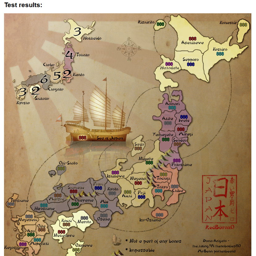
As to your first comment about the coords being the same or not from lrg. version to sml. version. Take notice of my last post, the one with the 4 ships....It has been reduced 10% in size, so it can be tested with the numbers. I threw a few numbers up, on some of the tightest areas. It seems to me, that while a little tight, they are clear and do not cover any border lines. So this all means that the lrg. and sml. versions, will be identical, when it comes to the names coordinates, and some of the numbers will need to be nudged out of line a hair or two. So much for the perfect Fung-Shway. But, it will not be all that noticeable.
To be honest, I don't care how common or uncommon it is. Misrepresenting the size of stuff is a dangerous game when it comes to maps, in my opinion. I think the numbers fit over the island borders just fine and it still looks good. The numbers could also fit alongside the island if necessary, it's not like they're going to drown. In this case, and I know this is way past due, but Okinawa is bigger than Tokyo when in reality its far smaller. Should it have been enlarged to fit numbers inside of it? In my opinion no, but Red decided yes. Should Rishorito, Sado, Izu-Oshima, ect get a cancerous bulb of land to accommodate numbers, no as it misrepresents the land forms in shape as well as size. Ultimately it breaks the fundamental purpose of maps, games or not.
Sketchblog [Update 07/25/11]: http://indyhelixsketch.blogspot.com/
Living in Japan [Update 07/17/11]: http://mirrorcountryih.blogspot.com/
Russian Revolution map for ConquerClub [07/20/11]: viewtopic.php?f=241&t=116575
Living in Japan [Update 07/17/11]: http://mirrorcountryih.blogspot.com/
Russian Revolution map for ConquerClub [07/20/11]: viewtopic.php?f=241&t=116575
-
Industrial Helix
- Posts: 3462
- Joined: Mon Jul 14, 2008 6:49 pm
- Location: Ohio
Re: Japan - 日本 (D, Gp, Gr) V14.0 XML checked ready to go
![]() by porkenbeans on Sun Jan 31, 2010 4:46 pm
by porkenbeans on Sun Jan 31, 2010 4:46 pm
I respect your thoughts on this, but consider this. The overall theme of this, (so called) map, is one of an ancient, antique sort of feel. So, if it were to have a more contemporary thing going on, you would be right. As today we have satellites in space, and very accurate means of measuring the globe. Yesterday, we did not possess such things, and therefor, our maps are less accurate the farther you go back in time.Industrial Helix wrote:porkenbeans wrote:Slightly altering the shape and/or size of a territ is common operating procedure in cartography. And even more common when maps are used in a board game. Geographical precision and correctness, takes the back seat, when it comes time to make a game, from a map. Try to remember, that this is First a game, and not an exact geographical representation.
For clarity and function, I believe that the smallest "island" territs, should be large enough to fit the numbers inside its borders, and be sufficiently large enough to discern that it is an island, and not appear as some numbers out floating in the water.
As to your first comment about the coords being the same or not from lrg. version to sml. version. Take notice of my last post, the one with the 4 ships.
To be honest, I don't care how common or uncommon it is. Misrepresenting the size of stuff is a dangerous game when it comes to maps, in my opinion. I think the numbers fit over the island borders just fine and it still looks good. The numbers could also fit alongside the island if necessary, it's not like they're going to drown. In this case, and I know this is way past due, but Okinawa is bigger than Tokyo when in reality its far smaller. Should it have been enlarged to fit numbers inside of it? In my opinion no, but Red decided yes. Should Rishorito, Sado, Izu-Oshima, ect get a cancerous bulb of land to accommodate numbers, no as it misrepresents the land forms in shape as well as size. Ultimately it breaks the fundamental purpose of maps, games or not.
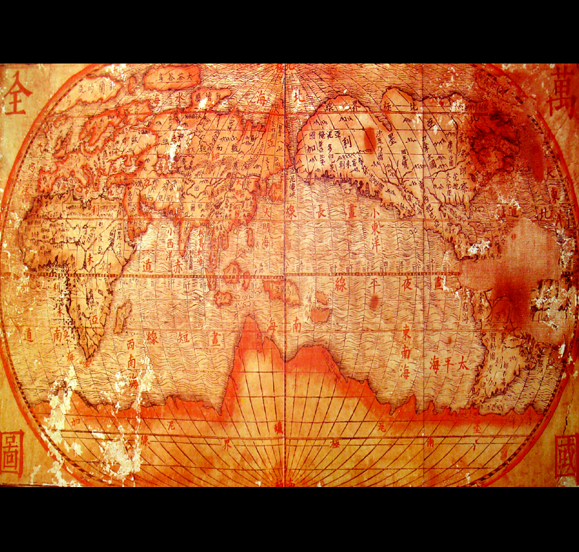
I have included below an authentic, ancient Chinese map. take note of all the inaccuracies.
If this map were to have some inaccuracies represented, I believe that it would NOT be out of line. On the contrary, They would be in perfect sync, with the theme of this game (map).
- Click image to enlarge.
-
porkenbeans
- Posts: 2546
- Joined: Mon Sep 10, 2007 4:06 pm
Re: Japan - 日本 (D, Gp, Gr) V14.0 XML checked ready to go
![]() by jefjef on Sun Jan 31, 2010 5:47 pm
by jefjef on Sun Jan 31, 2010 5:47 pm
Perhaps RBO would like to tweek his own work. We all chipped in our 2 cents worth. He's at the finish line.
Great work RBO!
Great work RBO!
This post was made by jefjef who should be on your ignore list.
drunkmonkey wrote:I'm filing a C&A report right now. Its nice because they have a drop-down for "jefjef".
-
jefjef
- Posts: 6026
- Joined: Mon Feb 23, 2009 8:41 pm
- Location: on my ass
Re: Japan - 日本 (D, Gp, Gr) V14.0 XML checked ready to go
![]() by porkenbeans on Sun Jan 31, 2010 6:17 pm
by porkenbeans on Sun Jan 31, 2010 6:17 pm
The only difference between my tweaks and your tweaks, is, mine are offered with illustrations. While you, along with most, do not very seldom, produce an illustrated example of your tweak. Instead we only see people always offering a million different ideas, some good, some bad. Most bad.jefjef wrote:Perhaps RBO would like to tweek his own work. We all chipped in our 2 cents worth. He's at the finish line.
Great work RBO!
I look at it this way, If a person took the time, and went the extra step to make an illustrated example of an idea or two, for one of my projects, I would take it as an "above and beyond" kind of gesture. It surely tells me one thing, that person wants to be on the team, and I will certainly give his posts, a little more than its fair share, of the allocated time for considering ideas and suggs. I may like or hate the idea, but I will appreciate the extra effort. Also it has saved me some time, as now I can quickly judge if it is a sugg that I want to pursue or not.
-
porkenbeans
- Posts: 2546
- Joined: Mon Sep 10, 2007 4:06 pm
Who is online
Users browsing this forum: No registered users
|
|||||||
| Conquer Club is not associated with RISK online in any way. Copyright © 2006-2024 by Big Wham LLC | |||||||