Conquer Club

[Abandoned] - Second Indochina War

Abandoned and Vacationed maps. The final resting place, unless you recycle.

Moderator: Cartographers

Forum rules
Please read the Community Guidelines before posting.

Re: The 2nd Indochina war

Postby grifftron on Fri Jan 21, 2011 10:48 am

FarangDemon wrote:I've decided to do a 2nd draft of the rework using google maps geocoding. Better to wait for that rather than attempt to decipher my notes. This is way more accurate than they were anyway.


Ok sounds good FD. I am in Chiang Mai this coming week for about 10 days. Ill try to get on some.

-griff
Image
User avatar
Major grifftron
SoC Training Adviser
 
Posts: 3280
Joined: Thu Jul 09, 2009 6:11 am

Re: The 2nd Indochina war

Postby FarangDemon on Sat Jan 22, 2011 11:05 am

Hey Grifftron - Here is a sneak peak. It is mostly complete, I just left out the area around Saigon, which has always been pretty cluttered in our previous incarnations.

It's not ready for you to begin working from it yet - please just let me know if you think the size of the territs I have so far here is workable - then I'll work out the Saigon area and add other details.

Light blue border separates territs within same bonus region. Darker blue means impassable border within bonus region. Black border is used to demarcate bonus regions, dark black means impassable.

http://www.killersapp.com/Second%20Indochinese%20War%20-%20Revamp.htm

Click image to enlarge.
image
Click image to enlarge.
image

"He came dancin across the water.... FarangDemon, FarangDemon.... mmmhh....what a killer..."
User avatar
Brigadier FarangDemon
 
Posts: 700
Joined: Wed Apr 23, 2008 1:36 am

Re: The 2nd Indochina war

Postby grifftron on Sun Jan 23, 2011 9:15 am

I like the look of the terts, it would be interesting FD, you would have to come up with some way of putting in mountains, rivers or whatever in those impassible areas. I opened up your sketch there, stretched it a bit in a 800x800 draft, put in black areas for the key on the side & top there (this could change, we could always move the key around some where else if it looks better). I also put enlarged 888's on the terts that i was concerned about, that is what the "small" version would look like in a way, you can see that some terts would be impossible to put both tert names along with the digi 888's in so we would for sure run into problems.

Click image to enlarge.
image


-griff
Image
User avatar
Major grifftron
SoC Training Adviser
 
Posts: 3280
Joined: Thu Jul 09, 2009 6:11 am

Re: The 2nd Indochina war

Postby FarangDemon on Sun Jan 23, 2011 2:23 pm

That's great what you did, putting in the numbers and key like that. Yeah I see the issue with not being able to fit labels and numbers in the territs...

Maybe we can try the following to increase the size of our map (in order to avoid having to clump regions together and using too many abbreviations):

  • Trim the ocean from the east side of the map (I know I didn't mention it yet, but I think we can do away with the ocean connecting lines in this version)
  • Remove the key from the top
  • Enlarge the map portion so it goes all the way up to the top of the screen
    • So we'll only have the key on the left side
    • We can put the map title in the body of water just SE of Haiphong

Let's see how well names can fit in the territs like this...
I hope most of them fit, otherwise we'd need to make extensive use of abbreviations.

Once we get the size issues worked out, I'll finalize territs and borders in my draft version, and then formulate suggestions on how to graphically visualize those borders.
Click image to enlarge.
image

"He came dancin across the water.... FarangDemon, FarangDemon.... mmmhh....what a killer..."
User avatar
Brigadier FarangDemon
 
Posts: 700
Joined: Wed Apr 23, 2008 1:36 am

Re: The 2nd Indochina war

Postby grifftron on Mon Jan 24, 2011 8:10 am

This is about what the SMALL version would look like FD according to your last post, some of those terts are just so tiny... they rest would be fine tho.

Click image to enlarge.
image


-griff
Image
User avatar
Major grifftron
SoC Training Adviser
 
Posts: 3280
Joined: Thu Jul 09, 2009 6:11 am

Re: The 2nd Indochina war

Postby grifftron on Fri Jan 28, 2011 4:38 am

FD maybe we drop the original map size and move this map up to a larger size now that they have the new regulations on maps sizes

SuperSize limits: 1000x800 pixels for a small map, and 1400x1200 pixels for a large map

We could fit a ton in there with those sizes! If i understand correctly we can do both small map & large maps to the sizes above without having to do the older size limits, that would be great!

we will wait until after you get that new sketch out tho.

-griff
Image
User avatar
Major grifftron
SoC Training Adviser
 
Posts: 3280
Joined: Thu Jul 09, 2009 6:11 am

Re: The 2nd Indochina war

Postby FarangDemon on Fri Jan 28, 2011 12:44 pm

Yes if we can supersize it, that gives us more options. Otherwise we can just consider a scaled down version. We can start with what I have now anyway.

Here is the google map (uploaded to same URL as previous):

http://www.killersapp.com/Second%20Indochinese%20War%20-%20Revamp.htm

Please note, I didn't sketch entire outline of NW Laos and North/NW Vietnam but I want it to be included in the map. Just check the map for how it should look. Note also that I do not want to include any of Thailand north of Phitsanulok as it was not relevant to this conflict. You could just put mountains along the Thai side north of Phitsanulok. I think that is preferable to making Phitsanulok reach all the way up north...

Another note: I took some liberties to simplify my work, creating straight edges where the borders are actually curved. In some places, like the border between Mondolkiri and Kratie, my sketch is quite accurate. But between Champasak and Attapeu, I didn't go to so much trouble. Please use the actual political/municipal boundaries where it is apparent from my sketch (as overlaid on top of googlemaps) that the borders follow the actual boundaries.

Impassables

note: Impassables that separate regions of different bonus regions are thick dark black in my sketch. Impassables that separate regions within the same bonus region are dark blue. I did this so you can easily see the black outline which separates bonus regions, regardless of whether parts of the border are impassable or not.

between Thailand and Laos - river
between N. Vietnam and Laos - mountains
within Laos - mountains (indicated in my map by darker blue borders between Laos regions)
between Laos and Cambodia - forests
between Cambodia and Thailand - mountains
between E. Cambodia and S. Vietnam - mountains
between S. Cambodia and S. Vietnam - forest
between N. Vietnam and S. Vietnam - DMZ (some kind of special graphic...)

Starting Locations

I'd like to keep the original starting locations with two modifications:

  • Pathet Lao Caves

    We'll add a note in the legend that the starting location of Pathet Lao Caves can assault and be assaulted by Houaphan. It's too small to graphically represent within Houaphan province, and would also get a bit hairier given that we still want to make Houaphan a bombing target but exclude Pathet Lao Caves from being bombed (because they were safe inside the caves). Doing this also makes it so that Pathet Lao Caves is not too close to Hanoi or Vientiane.

  • Khe Sanh

    This is the US Army starting location. It is the northernmost region of S. Vietnam and will have a US Army icon on it. As will Pattaya, Mobile Riverine Force and 1st Cav Div. I think we'll have these four US Army icon regions be a +2/+3 bonus and all attack one another like the naval bases in Philippines map.

I'll provide a list of territory names shortly.
Last edited by FarangDemon on Fri Jan 28, 2011 3:03 pm, edited 3 times in total.
Click image to enlarge.
image

"He came dancin across the water.... FarangDemon, FarangDemon.... mmmhh....what a killer..."
User avatar
Brigadier FarangDemon
 
Posts: 700
Joined: Wed Apr 23, 2008 1:36 am

Re: The 2nd Indochina war

Postby FarangDemon on Fri Jan 28, 2011 1:16 pm

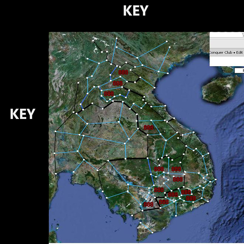
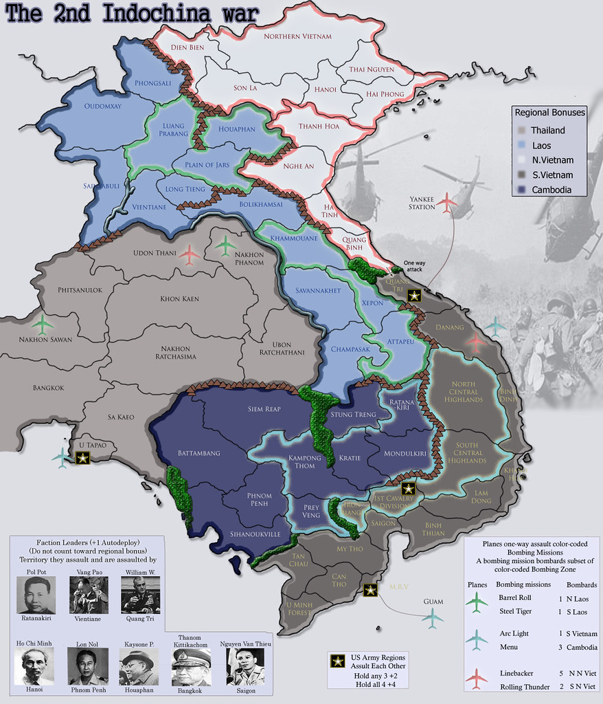
Territories ordered by northernmost point of each region within the bonus region

Thailand (9)

Udon Thani, Nakhon Phanom, Phitsanulok, Khon Kaen, Ubon Ratchathani, Nakhon Sawan, Khorat, Bangkok, Chonburi

Cambodia (9)


Ratanakiri, Stung Treng, Siem Reap, Battambang, Kratie, Mondolkiri, Phnom Penh, Sihanoukville, Prey Vieng

Laos (14)

Phongsali, NW Laos, Luang Prabang, Houaphan, (Pathet Lao Caves), Plain of Jars, Long Tieng, Vientiane, Bolikhamxay, Khammouane, Savannakhet, Xepon, Champasak, Attapeu

North Vietnam (8)


Dien Bien Phu, Northern Vietnam, Hanoi, Hai Phong, Son La, Thanh Hoa, Vinh, Dong Hoi

South Vietnam (15)


Khe Sanh, Danang, Pleiku, Quy Non, Buon Ma Thuot, Nha Trang, Da Lat, 1st Cav Div, Cu Chi Tunnels, Long Khanh, Saigon, My Tho, Tan Chau, Can Tho, U Minh Forest

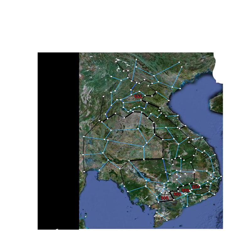
Other smaller territs I hope we will add to the map later...

  • Pattaya (located within Chonburi region)
  • Mobile Riverine Force (graphically represented on the water because I think there is more room there, borders Can Tho and My Tho)
Click image to enlarge.
image

"He came dancin across the water.... FarangDemon, FarangDemon.... mmmhh....what a killer..."
User avatar
Brigadier FarangDemon
 
Posts: 700
Joined: Wed Apr 23, 2008 1:36 am

Re: The 2nd Indochina war

Postby grifftron on Fri Jan 28, 2011 3:17 pm

Ill really need some downtime to read that stuff above and get it down, i am just testing the digis on the new map style to make sure we have no complications in the future FD. Since we SUPERSIZED it, i think we got the GO :mrgreen: :shock: :-$

1400hx1200w
Click image to enlarge.
image


933hx800w
Click image to enlarge.
image


if we could get a mod to concur that those would be OK size wise with the dimensions i used that would be great. And we could always move this back into the chop shop since we are totally changing the game play.... or leave it here, whatever.

***once i do work on graphics i am going to move away from the google earth look of our original versions and try something new out for once.


-griff
Image
User avatar
Major grifftron
SoC Training Adviser
 
Posts: 3280
Joined: Thu Jul 09, 2009 6:11 am

Re: The 2nd Indochina war

Postby grifftron on Sun Jan 30, 2011 4:33 am

I was looking for a map with exact locations for where the boarders should be for each tert. Couldn't find anything for this entire map, you have a link FD? or will have just have to rough it? I would like it to be exact locations.. otherwise we would get yelled at later on.

-griff
Image
User avatar
Major grifftron
SoC Training Adviser
 
Posts: 3280
Joined: Thu Jul 09, 2009 6:11 am

Re: The 2nd Indochina war

Postby FarangDemon on Sun Jan 30, 2011 6:29 am

grifftron wrote:I was looking for a map with exact locations for where the boarders should be for each tert. Couldn't find anything for this entire map, you have a link FD? or will have just have to rough it? I would like it to be exact locations.. otherwise we would get yelled at later on.

-griff


I tried to use provincial borders everywhere except Thailand and western Cambodia which I defined hurriedly and roughly. I used Google Maps to see provincial borders, but now realize it is a bit outdated regarding Laos. With Google Maps you can see all the provincial borders for all countries at once, otherwise you need to find individual provincial maps for each country.

Let's start with Laos. Here's a link to Provinces of Laos from Wikipedia.

http://en.wikipedia.org/wiki/Provinces_of_Laos

Image

Name to left is the name of province in my sketch, number on right corresponds to the province indicated in the Wikipedia map

Attapeu - 1 + 14
Champasak - 4 + western half of 12
Xepon - eastern halves of 13 and 12
Savannakhet - western half of 13
Khammouane - 6
Bolikhamxay - 3
Plain of Jars - northern half of 17
Long Tieng - sourthern half of 17
Vientiane - 15 + 16
Luang Prabang - 8
Houaphan - 5
Phongsali - 10
Northwestern Laos - 2, 7, 9, 11

If this works for you, I can provide info in same format for the rest of the countries.
Click image to enlarge.
image

"He came dancin across the water.... FarangDemon, FarangDemon.... mmmhh....what a killer..."
User avatar
Brigadier FarangDemon
 
Posts: 700
Joined: Wed Apr 23, 2008 1:36 am

Re: The 2nd Indochina war

Postby grifftron on Sun Jan 30, 2011 8:31 am

Thanks FD, i got them myself using your method of the wiki. Good idea... ill see what i can put together and PM you when its getting there.

-griff
Image
User avatar
Major grifftron
SoC Training Adviser
 
Posts: 3280
Joined: Thu Jul 09, 2009 6:11 am

Re: The 2nd Indochina war

Postby FarangDemon on Sun Jan 30, 2011 8:43 am

From the Provinces of Thailand Wikipedia map:

Image

Chonburi - all blue provinces (eastern Thailand)
Khorat - 10, 2, 16
Ubon Ratchathani - 15,17,1,19
Khon Kaen - 3,5,7,4,13
Udon Thani - 6,11,12,18
Nakhon Phanom - 14,9,8
Phitsanulok - 13,14,12 (maybe part of 5 and 15, western edge of map will go through it)
Nakhon Sawan - 9,6,4,20 (maybe part of 22, western edge of map will go through it)
Bangkok - the remaining ones south of Nakhon Sawan and west of Chonburi

From the Administrative Divisions of Cambodia Wikipedia map:

Image

(this one is named instead of numbered. btw I added a new one here that was not represented on my sketch, "Kampong Thom")

Ratanakiri - Ratanakiri
Mondulkiri - Mondulkiri
Stung Treng - Stung Treng
Kratie - Kratie
Siem Reap - Oddar Meanchey, Siem Reap, Preah Vihear
Kampong Thom - Kampong Thom, Kampong Cham
Prey Veng - Prey Vieng, Svay Rieng, S part of Kandal
Sihanoukville - Sihanoukville, Takeo, Kampot, Koh Kong
Battambang - Banteay Meanchey, Battambang, Pailin, Pursat
Phnom Penh - Kampong Chhnang, N part of Kandal, Phnom Penh (dark blue part I guess)
Click image to enlarge.
image

"He came dancin across the water.... FarangDemon, FarangDemon.... mmmhh....what a killer..."
User avatar
Brigadier FarangDemon
 
Posts: 700
Joined: Wed Apr 23, 2008 1:36 am

Re: The 2nd Indochina war

Postby grifftron on Sat Feb 05, 2011 7:13 am

FD & Myself are re doing the game play on this map, moving away from the lines and moving to basic terts. We have drafts in the making, just trying to finalize the gameplay before posting it

COMING SOON...

-griff
Image
User avatar
Major grifftron
SoC Training Adviser
 
Posts: 3280
Joined: Thu Jul 09, 2009 6:11 am

Re: The 2nd Indochina war

Postby FarangDemon on Sat Feb 12, 2011 1:14 am

Image
Click image to enlarge.
image

"He came dancin across the water.... FarangDemon, FarangDemon.... mmmhh....what a killer..."
User avatar
Brigadier FarangDemon
 
Posts: 700
Joined: Wed Apr 23, 2008 1:36 am

Re: The 2nd Indochina war

Postby grifftron on Tue Feb 15, 2011 9:43 am

Maybe move this back to melting or draft room, we will be posting soon, possibly tomorrow, but the gameplay has completely changed... what do you think mods? if they are giving out new stamps again in the draft room, why not move us back :lol: ;)

-griff
Image
User avatar
Major grifftron
SoC Training Adviser
 
Posts: 3280
Joined: Thu Jul 09, 2009 6:11 am

Re: The 2nd Indochina war

Postby natty dread on Tue Feb 15, 2011 9:44 am

Gameplay is allowed to completely change if you haven't received the gameplay stamp yet. There's no reason to move back to drafting room.
Image
User avatar
Sergeant 1st Class natty dread
 
Posts: 12877
Joined: Fri Feb 08, 2008 8:58 pm
Location: just plain fucked

Re: The 2nd Indochina war

Postby grifftron on Tue Feb 15, 2011 9:46 am

natty_dread wrote:Gameplay is allowed to completely change if you haven't received the gameplay stamp yet. There's no reason to move back to drafting room.


Fine. Party pooper
Image
User avatar
Major grifftron
SoC Training Adviser
 
Posts: 3280
Joined: Thu Jul 09, 2009 6:11 am

Re: The 2nd Indochina war

Postby isaiah40 on Tue Feb 15, 2011 2:55 pm

Well, if you really WANT to move back to the drafting room, I''m sure on of the mods would be more than obliging to it for you, though I don't think you'd get the Draft Stamp. :lol:

On another note, just continue the gameplay as you are fine sitting in here. ;)
Lieutenant isaiah40
 
Posts: 3990
Joined: Mon Aug 27, 2007 7:14 pm

Re: The 2nd Indochina war

Postby grifftron on Tue Feb 15, 2011 7:43 pm

isaiah40 wrote:Well, if you really WANT to move back to the drafting room, I''m sure on of the mods would be more than obliging to it for you, though I don't think you'd get the Draft Stamp. :lol:

On another note, just continue the gameplay as you are fine sitting in here. ;)


yeah we will stay here then.
Image
User avatar
Major grifftron
SoC Training Adviser
 
Posts: 3280
Joined: Thu Jul 09, 2009 6:11 am

Re: The 2nd Indochina war

Postby grifftron on Wed Feb 16, 2011 12:27 am

Now now.. don't go crying about the sucky graphics, and don't go crying about the size of the map, i know i could prob bring it down to the normal standard sizes of our CC maps then super-sizing it. Any ideas on the size? This is just to show what FD has changed the gameplay to so everyone can get an idea.

Click image to enlarge.
image


-griff
Image
User avatar
Major grifftron
SoC Training Adviser
 
Posts: 3280
Joined: Thu Jul 09, 2009 6:11 am

Re: The 2nd Indochina war [new gameplay]

Postby FarangDemon on Wed Feb 16, 2011 1:56 am

Regional Bonuses

As the continents are otherwise too big and too hard to defend given a standard bonus structure, I think we could use something like Berlin or England. It would also help every starting location have a near equal chance of growing at the same rate.

This is my initial idea:

    Cambodia, Laos, North Vietnam, South Vietnam

  • hold any 4: +1
  • hold any 6: +3
  • hold any 9: +6

    Thailand

  • hold any 5: +1
  • hold any 7: +3
  • hold any 10: +6

I think this adjustment for Thailand evens out the advantage of not being able to be bombarded and having neighbors who might not go for Thailand. Though the US Army likely will go for U Tapao, they may have no pressing need to venture deeper into Thailand.

I've purposely assigned the value of just +1 army for the lowest level of bonus in order to minimize the advantage one would get by dropping it, which would happen a lot in 4-player and even 6-player trips. So it's like Poker Club, you can drop a pair but you only get 1 more army than a High Card would.

Starting Positions

We've shifted our starting positions to the leaders - each player gets one leader. Each leader would start with, say 6 troops and assaults its corresponding region. To protect them from being attacked before a player's turn, the territories they assault could start neutral.

In addition to adding to the historic feel of the map, this new arrangement protects the starting positions of Kaysone Phomvihane and Pol Pot from bombardment. Now we don't need to worry about creating a small territory within a territory in Houaphan to represent the Pathet Lao caves which sheltered the Pathet Lao HQ from bombardment, as Kaysone is quite safe from bombardment under the new arrangement.

Bombing

The numbers in the legend refer to the neutral armies you need to go through before you can execute the bombardment. Territories with planes one-way assault the color-coded bombing missions (each color has two missions it could assault).

I chose the neutral starting values for the bombing missions to match the actual chronology of the war(s). Initially it is easy to bomb Laos and South Vietnam and North Vietnam below Hanoi. It should take a bit of time before violating Cambodian neutrality (Operation Menu) and the more comprehensive bombing of North Vietnam including Saigon and Hai Phong (Operation Linebacker). For the same reason we want Tet Offensive to have a high neutral starting value....

Tet Offensive

For an added gameplay twist (which should please the history-minded) I want to allow Ho Chi Minh to conduct the Tet Offensive. He could one-way attack a large neutral "Tet Offensive" which can one-way attack any South Vietnamese region except Mobile Riverine Force and 1st Cavalry Division. Based on the below map and from what I've read, it seems that every region we have except for those two was attacked during the offensive.

Image

Ho Chi Minh Trail

We've omitted the Ho Chi Minh Trail for now. But I still think it could be interesting to allow attacks to range 2 territories southbound along the Ho Chi Minh Trail. Maybe the forum can consider this possibility later, after having hammered out what we have currently proposed.
Click image to enlarge.
image

"He came dancin across the water.... FarangDemon, FarangDemon.... mmmhh....what a killer..."
User avatar
Brigadier FarangDemon
 
Posts: 700
Joined: Wed Apr 23, 2008 1:36 am

Re: The 2nd Indochina war [new gameplay]

Postby MarshalNey on Wed Feb 16, 2011 3:31 am

Griff, are you just being humble or trying the undersell?

These graphics are sweet for a gameplay draft- crisp, clean and legible. Plus they look nice. :)

The overall gameplay looks better. I really like the bombing missions, clearly a lot of thought went into those. The faction leaders are a nice way to simulate the Viet Minh/Viet Cong as opposed to the US with lots of little autodeploys instead of large bonuses on lone territories... although maybe it could be taken even further, I'll have to think on that.

What you're proposing FarangDemon for the continent bonuses with the building bonus (3-tiered superbonus) structure sounds workable, but perhaps unnecessary and might fill the legend up a bit much. Again, this is just a first impression, I'll take a closer look later.

Overall, a wonderful improvement =D>

-- Marshal Ney
User avatar
Captain MarshalNey
 
Posts: 781
Joined: Mon Sep 28, 2009 9:02 pm
Location: St. Louis, MO

Re: The 2nd Indochina war [new gameplay]

Postby kengyin on Wed Feb 16, 2011 3:39 am

the planes look like passenger liners
Sergeant kengyin
 
Posts: 226
Joined: Sun Sep 12, 2010 4:32 am

Re: The 2nd Indochina war [new gameplay]

Postby grifftron on Wed Feb 16, 2011 4:17 am

MarshalNey wrote:Griff, are you just being humble or trying the undersell?

These graphics are sweet for a gameplay draft- crisp, clean and legible. Plus they look nice. :)

The overall gameplay looks better. I really like the bombing missions, clearly a lot of thought went into those. The faction leaders are a nice way to simulate the Viet Minh/Viet Cong as opposed to the US with lots of little autodeploys instead of large bonuses on lone territories... although maybe it could be taken even further, I'll have to think on that.

What you're proposing FarangDemon for the continent bonuses with the building bonus (3-tiered superbonus) structure sounds workable, but perhaps unnecessary and might fill the legend up a bit much. Again, this is just a first impression, I'll take a closer look later.

Overall, a wonderful improvement =D>

-- Marshal Ney


Honestly I don't like the graphics i have here, it was just a quick draft FD & I were working on, i hope to make these graphics more appealing then my Thailand map has been at, I just need some fresh ideas for graphics and possibly new methods of doing things, i didn't want it to go in the same direction as what the Thailand map went in graphically. But thanks for the complements anyways :P

kengyin wrote:the planes look like passenger liners


Once again, its just to show the game play, i know the planes look like crap! THOSE ARE BOMBERS BTW! :)
Image
User avatar
Major grifftron
SoC Training Adviser
 
Posts: 3280
Joined: Thu Jul 09, 2009 6:11 am

PreviousNext

Return to Recycling Box

Who is online

Users browsing this forum: No registered users