Conquer Club

[Abandoned] - Washington State

Abandoned and Vacationed maps. The final resting place, unless you recycle.

Moderator: Cartographers

Forum rules
Please read the Community Guidelines before posting.

Re: Washington state counties(V2 OMG a mountain:P)

Postby mibi on Sun May 18, 2008 12:23 am

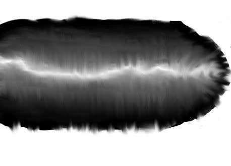
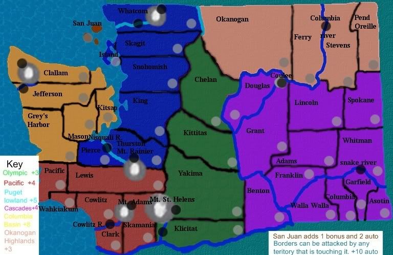
jarrett155 wrote:Probably not much better but im trying to make sort of a ridge thing. it would be for a mountain range.
Image


Thats some weird science yo!
User avatar
Captain mibi
 
Posts: 3350
Joined: Thu Mar 01, 2007 8:19 pm
Location: The Great State of Vermont

Re: Washington state counties(V2 OMG a mountain:P)

Postby jarrett155 on Sun May 18, 2008 12:25 am

constructive stuff please.
that looks like a foot doesnt help me much
Major jarrett155
 
Posts: 226
Joined: Tue Nov 27, 2007 6:25 pm

Re: Washington state counties(V2 OMG a mountain:P)

Postby RjBeals on Sun May 18, 2008 8:11 am

try the light source from the side, not straight down. It will give it more depth.
Image
User avatar
Private RjBeals
 
Posts: 2506
Joined: Mon Nov 20, 2006 5:17 pm
Location: South Carolina, USA

Re: Washington state counties(V2 OMG a mountain:P)

Postby oaktown on Tue May 20, 2008 8:29 am

mountains are tough - anybody who hasn't tried to make a map doesn't understand just how tough they are. I probably spent five hours this past weekend trying to come up with the right look for the mountains in my LA map.

The trouble with mountains is the element your create not only has to look like a mountain, but it has to fit with the other elements on your map. I see you're going for something with a satellite-image-reality look, but are you then going to make everything else look that way? The mountain you have come up would work on the right map, but I think it will be hard to complete the look.

I think that if I were you I would leave the mountain for later... work the rest of the map, see what kind of look you come up with, and then worry about how to shape a mountain. Right now I'd say your borders are a bigger problem.

Also - that mountain may actually look fine when scaled down to the size you'll actually use.
User avatar
Captain oaktown
 
Posts: 4451
Joined: Sun Dec 03, 2006 9:24 pm
Location: majorcommand

Re: Washington state counties(V2 OMG a mountain:P)

Postby jarrett155 on Tue May 20, 2008 9:05 pm

Click image to enlarge.
image

V 3 ish
borders are not dissolved.
Mountains still suck.
names for everything i think (never mind just checked) oops
Territory spots for a county are light grey in lower right corner of county. mountain and rivers are darker over the river/ next to mountain.
Major jarrett155
 
Posts: 226
Joined: Tue Nov 27, 2007 6:25 pm

Re: Washington state counties(V3 maybe)

Postby bedub1 on Tue May 20, 2008 9:42 pm

map needs to be split by the mountains....east vs west. cause they might as well be different states....
Colonel bedub1
 
Posts: 1005
Joined: Sun Dec 31, 2006 4:41 am

Re: Washington state counties(V3 maybe)

Postby TaCktiX on Tue May 20, 2008 9:54 pm

I tried to help, and I want you to ask yourself this serious question, jarrett: is what I'm doing anywhere near the standard of any map posted on this site? Your effort is admirable, but the map doesn't look good, and the graphical edits you're making seem like drops in a bucket not a quarter full. There are several tutorials available in Foundry Discussion to help you out, and I would highly suggest looking at them before going any further with this map.
User avatar
Corporal 1st Class TaCktiX
 
Posts: 2392
Joined: Mon Dec 17, 2007 8:24 pm
Location: Rapid City, SD

Re: Washington state counties(V3 maybe)

Postby RjBeals on Tue May 20, 2008 10:02 pm

nice water.
Image
User avatar
Private RjBeals
 
Posts: 2506
Joined: Mon Nov 20, 2006 5:17 pm
Location: South Carolina, USA

Previous

Return to Recycling Box

Who is online

Users browsing this forum: No registered users