[Abandoned] - Pacific Rim
Moderator: Cartographers
26 posts
• Page 1 of 2 • 1, 2
[Abandoned] - Pacific Rim
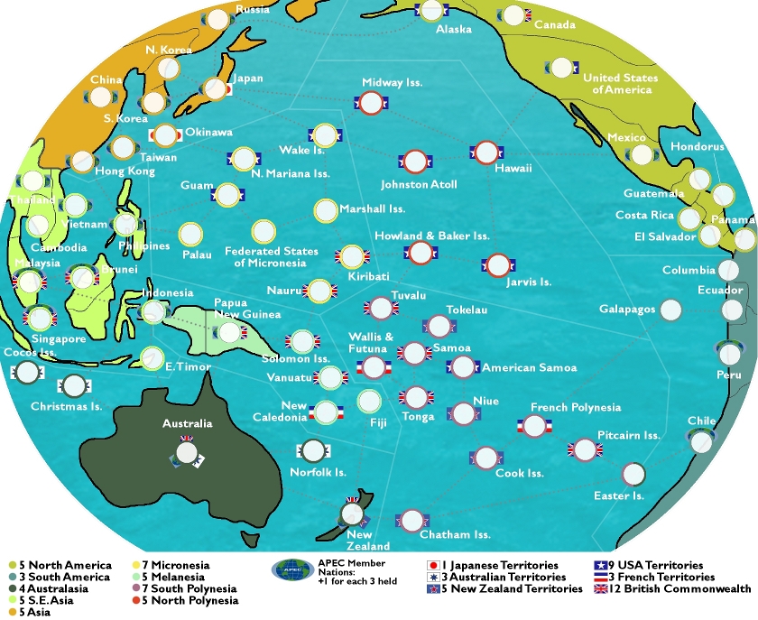
Here's a rough second-point-five draft for a Pacific Rim map:
Territories: 66
Continents: 9
Gameplay: can also get bonuses for holding all of a nation's territories (USA, British Commonwealth, etc.); plus holding APEC Member States will give a bonus (+1 for each 3 held: there are 21 APEC states, so max is +7)
Notes: Easter Island is part of both Polynesia & South America; Indonesia is part of both S.E. Asia & Melanesia.
Changes in V.2.5:
-Working on new ideas for indicating APEC Members: new prototypes are on Peru & Chile (APEC members with no other national affiliation); and on Singapore, Malaysia & Brunei (APEC members with a national affiliation, in these cases the British Commonwealth). The APEC logo now spans the top portion of the army circle, instead of trying to be part of the flag on one side (for example, as on China & the USA). Any ideas on how this might be done better are welcome.
-Small fixes, such as Brunei is no longer called Benin (though thinking about the two, I can kind of see how I confused them in my mind); the Commonwealth nations in SE Asia are no longer indicated as NZ Territories (oops).
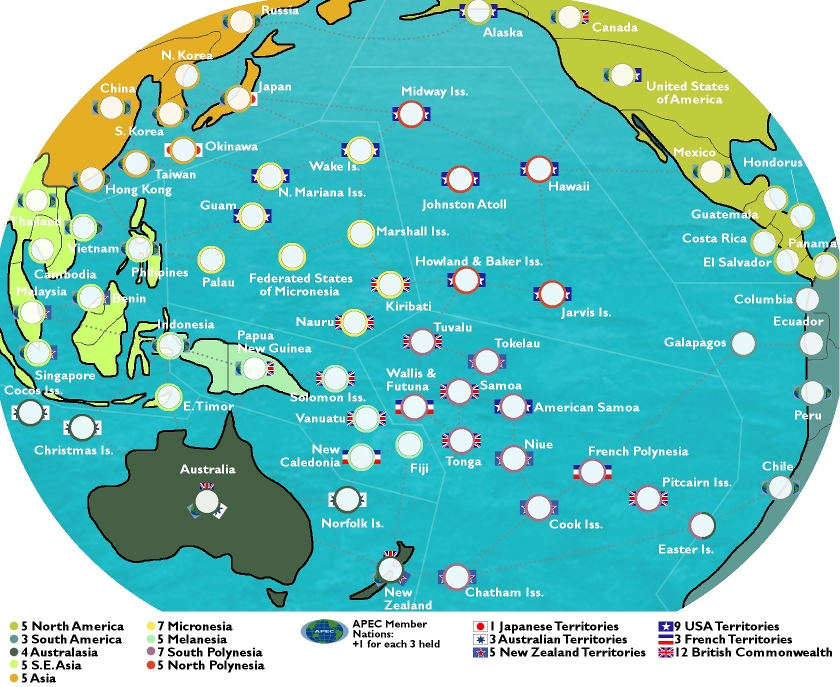
Changes in V.2:
-Increased territory count to 66
-Increased continent count to 9 (divided Polynesia into N & S)
-Complete graphics overhaul (though still need work)
-Secondary bonuses indicated by "flags" on either side of army circle (the APEC flag currently sucks...I'll work on it)
To Do:
-the attack route lines need to be darkened
-Honduras needs to be spelled correctly
-graphics need work in general
-continent colours of SE Asia & Melanesia need to be more differentiated
Second version:
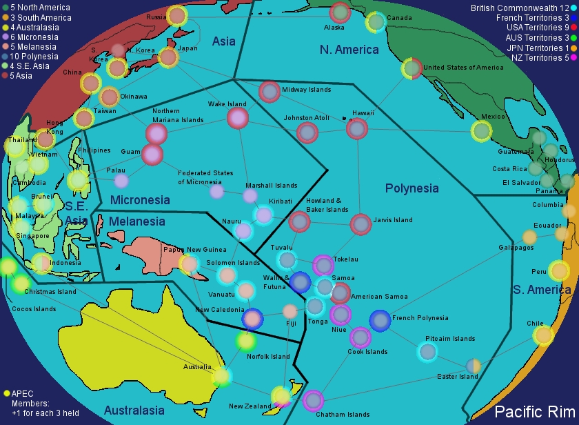
Original version:
Any thoughts on gameplay though?
LC
Last edited by Lobster Crush on Thu Mar 19, 2009 12:14 pm, edited 8 times in total.
-

 Lobster Crush
- Posts: 93
- Joined: Sun Mar 18, 2007 12:18 am
- Location: Winneapolis, Minnetoba


Re: Pacific Rim
a bonus for holding both the US and a set amount of American overseas territories would be nice
TheSaxlad wrote:The Dice suck a lot of the time.
And if they dont suck then they blow.
-

 Joodoo
- Posts: 1639
- Joined: Fri Mar 21, 2008 12:19 am
- Location: Greater Toronto, Canada


Re: Pacific Rim
Joodoo wrote:a bonus for holding both the US and a set amount of American overseas territories would be nice
I thought of doing it that way, but then I should do it that way for New Zealand and it's territories, Australia and it's territories, and then it gets weird with the British Commonwealth & the French territories, since neither Britain or France are on the map.
One thing I'm considering is splitting up Polynesia. I can't really imagine anyone holding it the way it is right now. Thoughts?
LC
-

 Lobster Crush
- Posts: 93
- Joined: Sun Mar 18, 2007 12:18 am
- Location: Winneapolis, Minnetoba


Re: Pacific Rim
It looks better than any of my map ideas but it seems to me a lot of the regions are crammed into the middle.
-
 ManBungalow
- Posts: 3431
- Joined: Sun Jan 13, 2008 7:02 am
- Location: On a giant rock orbiting a star somewhere


Re: Pacific Rim
ManBungalow wrote:It looks better than any of my map ideas but it seems to me a lot of the regions are crammed into the middle.
Thanks. At the moment, most of the territories are more-or-less where they should be geographically, which is why things are bunched up in the middle, and also bunched up in S.E. Asia. My next draft will bend reality a bit more to spread things out.
LC
-

 Lobster Crush
- Posts: 93
- Joined: Sun Mar 18, 2007 12:18 am
- Location: Winneapolis, Minnetoba


Re: Pacific Rim (V.2.5, Mar. 8)
Any more thoughts on this from anyone?
In particular, looking for ideas on how to indicate APEC member nations.
Cheers,
LC
In particular, looking for ideas on how to indicate APEC member nations.
Cheers,
LC
-

 Lobster Crush
- Posts: 93
- Joined: Sun Mar 18, 2007 12:18 am
- Location: Winneapolis, Minnetoba


Re: Pacific Rim (V.2.5, Mar. 8)
Yeah, That looks good, I had an Idea of making a map thats in a sphere shape or something, glad to know someone is using it. 
-
 Dublanous1
- Posts: 77
- Joined: Thu Sep 18, 2008 3:00 pm
- Location: NYC


Re: Pacific Rim (V.2.5, poll added Mar. 15)
Poll added today to figure out how to indicate APEC member states...let me know which you prefer!
Cheers,
LC
Cheers,
LC
-

 Lobster Crush
- Posts: 93
- Joined: Sun Mar 18, 2007 12:18 am
- Location: Winneapolis, Minnetoba


Re: Pacific Rim (V.2.5, Mar. 8)
Dublanous1 wrote:Yeah, That looks good, I had an Idea of making a map thats in a sphere shape or something, glad to know someone is using it.
Thanks Dublanous,
Using the sphere technique is the only way to squeeze all of the pacific onto one map, I figure...
Cheers,
LC
-

 Lobster Crush
- Posts: 93
- Joined: Sun Mar 18, 2007 12:18 am
- Location: Winneapolis, Minnetoba


Re: Pacific Rim (V.2.5, poll added Mar. 15)
I'm not too sure exactly what you're trying to achieve with the poll... It would be better to get more focus on how the map looks/feels/plays first?
It's a good solid draft so far, let's see how things develop
It's a good solid draft so far, let's see how things develop

PB: 2661 | He's blue... If he were green he would die | No mod would be stupid enough to do that
-

 MrBenn
- Posts: 6880
- Joined: Wed Nov 21, 2007 9:32 am
- Location: Off Duty


Re: Pacific Rim (V.2.5, poll added Mar. 15)
Hmm... 
Also, maybe you could make a sequel map? Like the other side of the world?
Also, maybe you could make a sequel map? Like the other side of the world?
-
 Dublanous1
- Posts: 77
- Joined: Thu Sep 18, 2008 3:00 pm
- Location: NYC


Re: Pacific Rim (V.2.5, poll added Mar. 15)
I am beginning to like this idea. Maybe give it more of a nautical feel
-

 sailorseal
- Posts: 2735
- Joined: Sun May 25, 2008 1:49 pm
- Location: conquerclub.com


Re: Pacific Rim (V.2.5, poll added Mar. 15)
MrBenn wrote:I'm not too sure exactly what you're trying to achieve with the poll... It would be better to get more focus on how the map looks/feels/plays first?
It's a good solid draft so far, let's see how things develop
Thanks MrBenn,
Really the poll was for two reasons: help me grapple with the trouble I'm having with the cartographic symbols, and to try to drum up some more interest & comments on the idea...
If anyone has comments on how the map could look/feel/play better, please, let me know...
Cheers,
LC
-

 Lobster Crush
- Posts: 93
- Joined: Sun Mar 18, 2007 12:18 am
- Location: Winneapolis, Minnetoba


Re: Pacific Rim (V.2.5, poll added Mar. 15)
Dublanous1 wrote:Hmm...
Also, maybe you could make a sequel map? Like the other side of the world?
Sounds like a great idea, Dublanous, though I'd like to get this one closer to completion before starting on the Atlantic...
Cheers,
LC
-

 Lobster Crush
- Posts: 93
- Joined: Sun Mar 18, 2007 12:18 am
- Location: Winneapolis, Minnetoba


Re: Pacific Rim (V.2.5, poll added Mar. 15)
sailorseal wrote:I am beginning to like this idea. Maybe give it more of a nautical feel
Great idea, sailorseal. I was having trouble coming up with an overal "theme," since there's a lot of South Pacific content, but also diverse territories like Alaska, Russia, Japan, Mexico, etc.
I'll give it some thought & see what I can come up with...
Cheers,
LC
-

 Lobster Crush
- Posts: 93
- Joined: Sun Mar 18, 2007 12:18 am
- Location: Winneapolis, Minnetoba


Re: Pacific Rim (V.2.5, poll added Mar. 15)
Some starting quick sugg:
On the whole i like it, i wanna see where you're going to....
- - your first post seems a little bit chaotic, how many images? (but it's personal)
- your first version is 840x616 pixels, your actual is 840x687 pixels, you added some pixels on height to move names, but i think put names in unused angles could be good choice.
- Use a better color for routes, in some points i can't see them
- Your globe is 840x687 now, so you cut the two poles and the outer parts on left and right. If you scale the globe to 800x586 you can add the mised parts, could be nicer.
- Use the original option for circles, but Benn said, could be a later choice.
- Sailor said good words, make this map nautical.
- Work on territories graphic now(not on circle), you can do them better
- there're a lot of territories in the centre of this big map, could be all these clear (names and symbols) on the small one?
On the whole i like it, i wanna see where you're going to....
-

 thenobodies80
- Posts: 5400
- Joined: Wed Sep 05, 2007 4:30 am
- Location: Milan


Re: Pacific Rim (V.2.5, poll added Mar. 15)
Thanks for all the comments, thenobodies80.
Yeah, all those images were just context for the poll.
I tried that on my first draft, and it seemed too squished to me. I'll play around with it again, though I'm thinking that the unused spaces might be better off with some nice graphic elements.
Agreed. I've really darkened them on a newer draft I've done which I'll hopefully finish up enough to post on the weekend.
To be honest, I've distorted the geography so much that showing the rest of the oval doesn't really make sense. I went with the current view to maximize the South Pacific for legibility/playability. Having a bit of Antarctica would be nice, but I don't see the point in including portions of the Arctic Sea on top, more of the Caribbean on the right, and more of Asia on the left. These are non-playable areas anyway.
Ok, I'll let my current obsession with the circles go. It's just that I'm trying to convey a lot of info in a small space (esp. on the South Pacific islands where the territory is the circle) that I wanted to get it sorted.
point taken.
Again, since so many of the territory graphics are nothing more than circles, I feel they're pretty important too.
I hope so!
Hopefully more to come on this on the weekend...stay tuned!
Cheers,
LC
thenobodies80 wrote:- your first post seems a little bit chaotic, how many images? (but it's personal)
Yeah, all those images were just context for the poll.
thenobodies80 wrote:- your first version is 840x616 pixels, your actual is 840x687 pixels, you added some pixels on height to move names, but i think put names in unused angles could be good choice.
I tried that on my first draft, and it seemed too squished to me. I'll play around with it again, though I'm thinking that the unused spaces might be better off with some nice graphic elements.
thenobodies80 wrote:- Use a better color for routes, in some points i can't see them
Agreed. I've really darkened them on a newer draft I've done which I'll hopefully finish up enough to post on the weekend.
thenobodies80 wrote:- Your globe is 840x687 now, so you cut the two poles and the outer parts on left and right. If you scale the globe to 800x586 you can add the mised parts, could be nicer.
To be honest, I've distorted the geography so much that showing the rest of the oval doesn't really make sense. I went with the current view to maximize the South Pacific for legibility/playability. Having a bit of Antarctica would be nice, but I don't see the point in including portions of the Arctic Sea on top, more of the Caribbean on the right, and more of Asia on the left. These are non-playable areas anyway.
thenobodies80 wrote:- Use the original option for circles, but Benn said, could be a later choice.
Ok, I'll let my current obsession with the circles go. It's just that I'm trying to convey a lot of info in a small space (esp. on the South Pacific islands where the territory is the circle) that I wanted to get it sorted.
thenobodies80 wrote:- Sailor said good words, make this map nautical.
point taken.
thenobodies80 wrote:- Work on territories graphic now(not on circle), you can do them better
Again, since so many of the territory graphics are nothing more than circles, I feel they're pretty important too.
thenobodies80 wrote:- there're a lot of territories in the centre of this big map, could be all these clear (names and symbols) on the small one?
I hope so!
Hopefully more to come on this on the weekend...stay tuned!
Cheers,
LC
-

 Lobster Crush
- Posts: 93
- Joined: Sun Mar 18, 2007 12:18 am
- Location: Winneapolis, Minnetoba


Re: Pacific Rim (V.2.5)
this looks nice but could you put a little blur(Gaussian) on the borders of the land, they are a little pix-elated.
will be back later
tlane
will be back later
tlane
sailorseal wrote:come on, now i am all sticky
-
 tlane
tlane
- Posts: 309
- Joined: Wed Oct 22, 2008 7:11 pm
- Location: NYC - sint maarten(sometimes)


Re: Pacific Rim (V.2.5)
I am not so sure what the map legend means, an you clarify it?
Nice Map!
Nice Map!
-

 sailorseal
- Posts: 2735
- Joined: Sun May 25, 2008 1:49 pm
- Location: conquerclub.com


Re: Pacific Rim (V.2.5)
Well, I just realized this will be a complicated map, the bonuses are all crammed onto the bottom and it would look better if you used more space for the bonuses and less for the map. Alot of the terits are crammed into the middle like MrBenn said, but also, how do you tell what territories attack what territories, it is really confusing now that I take a closer look. I hope you continue to pursue this map LS, because it would turn out a good map, but maybe a bit more simplified
-
 Dublanous1
- Posts: 77
- Joined: Thu Sep 18, 2008 3:00 pm
- Location: NYC


Re: Pacific Rim (V.2.5)
Just a word of encouragement, it seems very straight forward to me... though now that i look at it a second time, the connections are very hard to see. you may want to increase the contrast of the lines connecting the islands.
-

 ustus
ustus
- Posts: 291
- Joined: Thu Nov 20, 2008 3:49 pm


Re: Pacific Rim (V.2.5)
On the themes note, this area is also known as the Pacific Ring of Fire due to the number of volcanoes in the area, that could possibly be an idea to use, however i do prefer saliorseals idea of using a nautical theme
Soviet Invaders: Space Invaders, it's not just a game
New Zealand Map - Foundry
"You can please all of the people some of the time, or some of the people all of the time, but not all of the people all of the time"
New Zealand Map - Foundry
"You can please all of the people some of the time, or some of the people all of the time, but not all of the people all of the time"
-

 reggie_mac
- Posts: 299
- Joined: Fri Nov 30, 2007 4:06 pm
- Location: Queenstown, NZ


Re: Pacific Rim (V.2.5)
As I said before, you've made a really good start on this map.
The thing that confuses me the most, is that a lot of the territories appear to be in two regions... the dual-representation (circle colour / flag) is a really sweet touch, but is possibly a bit too subtle...
If you could find a way of making the region groupings clearer, and make the attack routes more visible, that would make gameplay analysis a lot easier

PB: 2661 | He's blue... If he were green he would die | No mod would be stupid enough to do that
-

 MrBenn
- Posts: 6880
- Joined: Wed Nov 21, 2007 9:32 am
- Location: Off Duty


Re: Pacific Rim (V.2.5)
[Moved]
It would appear that development of this map has stalled. If the mapmaker wants to continue with the map, then one of the CAs will be able to help put the thread back into the Foundry system, after an update has been made.
It would appear that development of this map has stalled. If the mapmaker wants to continue with the map, then one of the CAs will be able to help put the thread back into the Foundry system, after an update has been made.

PB: 2661 | He's blue... If he were green he would die | No mod would be stupid enough to do that
-

 MrBenn
- Posts: 6880
- Joined: Wed Nov 21, 2007 9:32 am
- Location: Off Duty


26 posts
• Page 1 of 2 • 1, 2
Who is online
Users browsing this forum: No registered users

