Page 1 of 17
Battle For Australia [Quenched]

Posted:
Fri Mar 02, 2007 1:36 pmby cairnswk
- Click image to enlarge.
YES
66% [ 109 ]
NO
23% [ 38 ]
UNDECIDED
10% [ 17 ]
Total Votes : 164
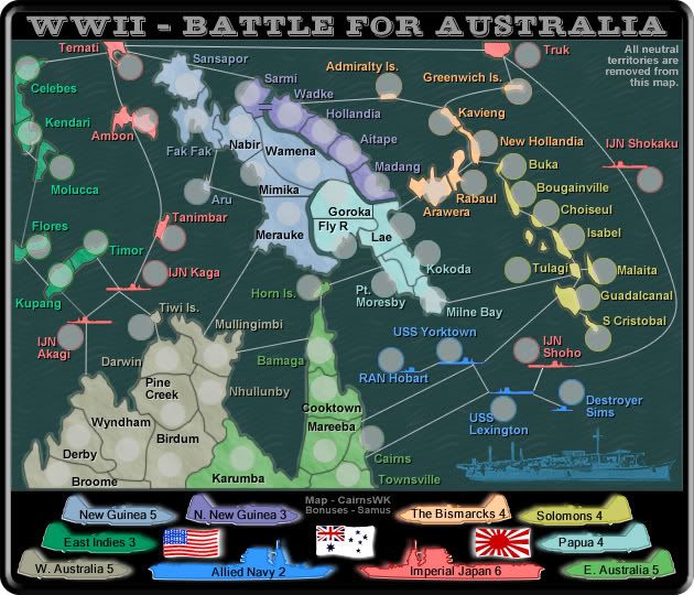
Original concept: during WW11 Australia, Papua New Guinea and the Solomons came under large attack from the Japanese in what has become known as the Battle for Australia.
Involved were several attacks on Townsville, but 234 people lost their lives in the largest attack on Darwin.
This map includes the infamous Coral Sea Battle - one of the turning points in this regional conflict for both the Allies and Australia, as well as the famous territories like Kokoda, Milne Bay and Guadalcanal.
See if U can keep the Japanese fleet at bay!
XML UpdateThe map starts with 48 territories in play, the other 18 territories are neutral..
Posted:
Fri Mar 02, 2007 1:40 pmby RjBeals
Good Idea and I love the battleships (would they be grouped as a bonus)?
There's got to be a way to not have so much wasted real estate. There is tons of wasted space, and no room for army numbers or names...
Posted:
Fri Mar 02, 2007 2:11 pmby cairnswk
RjBeals...thanks for your post...this map is no where near finished...there are tons more territories to go into it yet....but, this is preview!!!
Posted:
Fri Mar 02, 2007 2:12 pmby Qwert
well these will be more dificulty then my WW2 iwo jima map
Posted:
Fri Mar 02, 2007 2:35 pmby cairnswk
As yet Qwert...this is only preliminaries....as for more difficult than your Iwojima....I cannot say.
Posted:
Fri Mar 02, 2007 5:49 pmby Guiscard
Could be an interesting idea. Would definitely like to see it developed further.
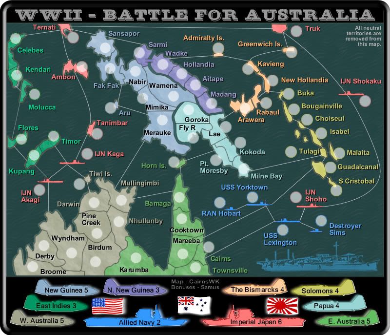
BATTLE FOR AUSTRALIA - ATTACK LINES
Posted:
Sat Mar 03, 2007 11:52 amby cairnswk
After much research, the attack lines are now in place. Suggestions welcome.
Bonuses also require debate.
Posted:
Sat Mar 03, 2007 7:51 pmby Samus
The territory name "Unoccupied Dutch West Indies" isn't gonna fly from just a game log standpoint, it's too long. And it borders about half the map.
You've got several different colored lines and I'm not sure what they all mean. The red lines with the arrows seem to imply one way attacking, but that would mean Australia can't attack the entire left side of the map. Other than that, the lines are, well, ugly as sin, lol. Sorry.

You are going to have a VERY hard time fitting the army number circles into Lower Papua.
Australia needs to be divided. I count 21 territories! That's insane....
Posted:
Sat Mar 03, 2007 8:34 pmby cairnswk
Thanks Samus for those suggestions...I'll modify map so everything is clearer, now that I've had a good break from it, and got the yard mowed....i feel so much better now that i've cut the heads off some blades of grass...LOL.
WATCH THIS SPACE!
Posted:
Sat Mar 03, 2007 9:08 pmby Shacekenhall
Those are the grafics or you can improve it??
Posted:
Sat Mar 03, 2007 10:40 pmby cairnswk
Shacekenhall....no these are not final graphics....I am sure I will be able to improve it....thanks for your post.
Posted:
Sun Mar 11, 2007 6:14 pmby The BlueBeards
Greetings All,
Looking at this map has motivated me to make my first post on this site.

Cairnswk, I like the whole concept and so far it looks good. What else would it need really to be usable? I guess the graphic could be snazzed up, but really I like it as is.
So how can somebody play this map online?
Posted:
Mon Mar 12, 2007 3:03 amby cairnswk
Thanks, The BlueBeards!
Welcome to posting re the maps.
So far this is not playable online...indeed there is a lengthy process to have this map evaluated and discussed in this forum as to its worthiness for gameplay.
If you are really interested in getting this map up and available for play, please tell everyone you know to come and provide feedback and vote for this map.
As to the graphics, the current map was the general idea for determining if there is any interest...at present I am running with this so the more feedback, the more interest there might be to play the map. Graphics have a long way to go, and then gaameplay/bonuses etc must be determined.
Please continue to monitor this post.
Posted:
Mon Mar 12, 2007 3:43 amby KEYOGI
Looking very cluttered at the moment, I'm having a hard time even telling which territory is which. You might need to sacrifice some accuracy for playabiltiy and design. I think it's important to be able to look at a map and straight away be able to identify territories, borders, attack routes, etc. I'd start with losing all the ships and different attack routes and just simplify the whole thing.

Posted:
Mon Mar 12, 2007 3:50 amby cairnswk
Thanks Keyogi. There is still some research I have to do to determine Japanese attack routes from New Guinea. Then I will be able to look at simplifaction and graphics of course. But hope this creates interest!
Posted:
Mon Mar 12, 2007 5:07 amby boberz
this needs to be cleaned up a little muddled and confused after a quick glance
Posted:
Wed Mar 14, 2007 4:02 pmby cairnswk
15Mar V2 Update - Simplified Battle lines and color change.

Posted:
Wed Mar 14, 2007 4:03 pmby boberz
glancing at it it still confuses me i am too tired to work out why but i know that graphically it needs to be tidied up a lot
Posted:
Wed Mar 14, 2007 4:23 pmby MarVal
I like the Dutch West Indies.
Nice map, only imporve the visibilty. The gameplay will be great.
Go on and this will be a playable map.
Grtz
MarVal
Posted:
Sat Mar 17, 2007 5:08 amby cairnswk
17Mar V3 Update - re-design.
MarVal...thanks for the feedback!
I decided to give this map its' unique flavour...like a War Trophy on a piece of stained veneer.
Hope everyone enjoys....

Posted:
Sat Mar 17, 2007 5:25 amby onbekende
Kick following territories (my suggestions)
Biak, Choisuel.
perhaps join some territories:
Arawera + N.. Britain + Rabaul (that island)
Bosabura + Gona-Buna + Kokoda (middle of that continent)
P. Morseby + Tufi + Miine Bay (south of that continent)
Kill some islands not used
Make image bigger
Posted:
Sat Mar 17, 2007 5:54 amby Qwert
You need water for ocean.
Its look that you have very small terittory
Posted:
Sat Mar 17, 2007 7:43 amby cairnswk
Qwert...water can represented by many things...it doesn't have to be blue in colour, and it doesn't have to have wave texture.
The water in this case is represented by a wooden background.
It is called "artisitc license" in case you haven't heard of it....the same sort of artistic license you used in your Iwajima map. Thanks for your response anyway.
Posted:
Sat Mar 17, 2007 9:06 amby DiM
1. the red and blue text from the ships is unreadable.
2. you have very small territories it's gonna be a bitch arranging the army numbers.
3. what the heck is the red thing from the bottom it looks like lava or something.
Posted:
Sat Mar 17, 2007 9:09 amby Skittles!
DiM wrote:1. the red and blue text from the ships is unreadable.
2. you have very small territories it's gonna be a bitch arranging the army numbers.
3. what the heck is the red thing from the bottom it looks like lava or something.
It's Ayres Rock, or Uluru.
And why is it there? It's more South. The map doesn't need it. It makes it look bad. Also, the lines from the ships don't look too nicely with the background.