Who cares about geographical accuracy? Long names are bad enough on maps, two names are horrendous.
Also, can you make the one way wall an actual stone wall or something? And I hope you're going to change the thick lines for impassables into something?
[Official] British Isles REVAMP [Quenched]
Moderator: Cartographers
![]() by gimil on Wed Dec 05, 2007 1:46 am
by gimil on Wed Dec 05, 2007 1:46 am
wicked wrote:Who cares about geographical accuracy? Long names are bad enough on maps, two names are horrendous.
Yeti_C cares very much for the acuracy of this map
I think your exaggerating the name situation. Ill wait for more feedback to see where to take it.
What do you know about map making, bitch?
Top Score:2403
natty_dread wrote:I was wrong
Top Score:2403
-

 gimil
gimil
- Posts: 8599
- Joined: Sat Mar 03, 2007 12:42 pm
- Location: United Kingdom (Scotland)


![]() by jaydog on Wed Dec 05, 2007 1:48 am
by jaydog on Wed Dec 05, 2007 1:48 am
I am with happy2seeyou, Please don't change his map!
This map copuld be considered CC history as it was one of the first new maps introduced back in the day, it is a classic map, do a Ireland 2.0 or something else. this map should be left alone
This map copuld be considered CC history as it was one of the first new maps introduced back in the day, it is a classic map, do a Ireland 2.0 or something else. this map should be left alone
-

jaydog
- Posts: 468
- Joined: Fri Jan 27, 2006 7:24 pm
- Location: on the other side of the planet


![]() by moomaster2000 on Wed Dec 05, 2007 1:49 am
by moomaster2000 on Wed Dec 05, 2007 1:49 am
Yea. Don't be like George Lucas and make Re-Releases making the movies horrible. This is a similar case. It looks just, weird.
-

moomaster2000
- Posts: 509
- Joined: Tue Jun 12, 2007 12:19 am
- Location: Encinitas, CA
![]() by wicked on Wed Dec 05, 2007 1:55 am
by wicked on Wed Dec 05, 2007 1:55 am
gimil wrote:wicked wrote:Who cares about geographical accuracy? Long names are bad enough on maps, two names are horrendous.
Yeti_C cares very much for the acuracy of this map
I think your exaggerating the name situation. Ill wait for more feedback to see where to take it.
Not exaggerating at all. As someone's who's played the map a great deal, having two names will be bloody annoying. There's no room for two names in the dropdown menu anyway. I was told in another map thread that sometimes geographical accuracy can be skewed a bit to make the map work. Well the map works as is, don't change the names.
-

wicked
- Posts: 15787
- Joined: Thu Jan 26, 2006 1:23 pm


![]() by reverend_kyle on Wed Dec 05, 2007 1:57 am
by reverend_kyle on Wed Dec 05, 2007 1:57 am
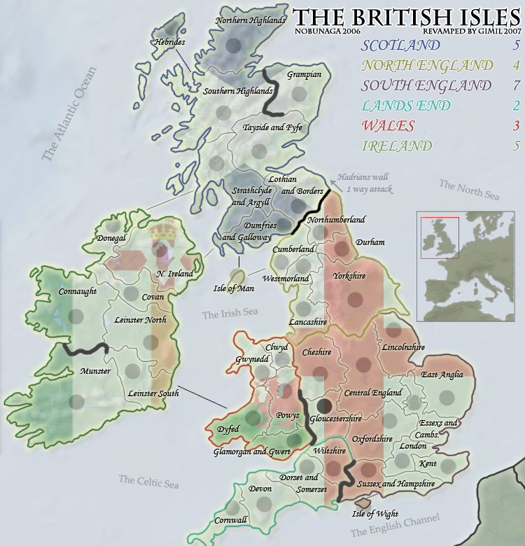
Additionally, do something with the flags similar to in great lakes, right now I'm going to have to say the original looked better. The flags just seem TOO busy.
DANCING MUSTARD FOR POOP IN '08!
-

reverend_kyle
- Posts: 9250
- Joined: Tue Mar 21, 2006 4:08 pm
- Location: 1000 post club


![]() by lord voldemort on Wed Dec 05, 2007 2:03 am
by lord voldemort on Wed Dec 05, 2007 2:03 am
make the flags perhaps a lil more seethrough, its also confusing with the north england and south england continent bonus having same flag...
i think the flag background idea is good, but need to be perfected a lil more..cause as people have said, it really does stand out a little bit too much
i think the flag background idea is good, but need to be perfected a lil more..cause as people have said, it really does stand out a little bit too much

-

lord voldemort
- Posts: 9596
- Joined: Sat Oct 20, 2007 4:39 am
- Location: Launceston, Australia


![]() by Coleman on Wed Dec 05, 2007 2:58 am
by Coleman on Wed Dec 05, 2007 2:58 am
I think gimil is getting a lot of unnecessary attention here. The original author wants the map redone. If the original author wanted we would have to pull their map from the site, not just redo it. All the maps we get to play on belong to users who let lack use them through an agreement.
We've had complaints about the inaccuracy of British Isles for a long time. The goal of this revamp from my point of view is to improve the graphics and the accuracy of the map.
If you don't want this map redone pm Nobunaga and look at the topic he made : http://www.conquerclub.com/forum/viewtopic.php?t=35358
-

Coleman
- Posts: 5402
- Joined: Tue Jan 02, 2007 10:36 pm
- Location: Midwest


![]() by rebelman on Wed Dec 05, 2007 6:01 am
by rebelman on Wed Dec 05, 2007 6:01 am
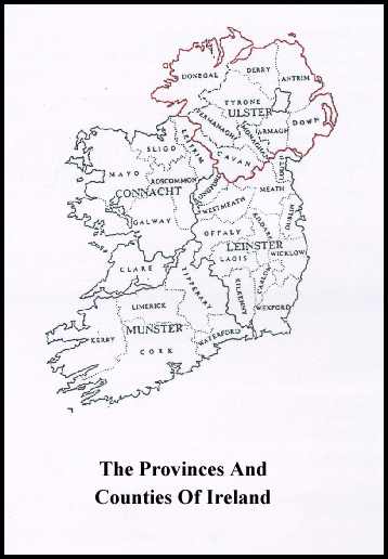
I am all for geographic accuracy but the first inaccuracy that needs to be addressed is the map's title The British Isles as for as the Irish Government are concerned those not include the Republic of Ireland
http://en.wikipedia.org/wiki/British_Is ... ng_dispute
The following article outlines how this inaccuracy is being corrected in atlases in Irish schools: (Folens are the main publisher of school books in Ireland)
This geographic region that you are trying to depict more accurately on this map is actually an archipelago of more than 6,000 islands, the two biggest being Great Britain and Ireland. Great Britain, to the east, covers 216,777 km² (83,698 sq. miles), over 2/3 of the total archipelago; Ireland, to the west, covers 84,406 km² (32,589 sq. miles). The other larger islands are situated to the north-west of the archipelago - the Hebrides and Shetland Islands.
The islands that constitute the archipelago include:
Great Britain
Ireland
Northern Isles (including Orkney, Shetland and Fair Isle)
Hebrides (including the Inner Hebrides, Outer Hebrides and Small Isles)
Islands of the lower Firth of Clyde (including the Isle of Arran and Bute)
Anglesey (in Welsh Ynys Môn)
Isles of Scilly
Isle of Wight
Portsmouth Islands (including Portsea Island and Hayling Island)
Islands of Furness
Isle of Portland
Ulster: Arranmore, Tory Island, Rathlin Island
Connacht: Achill Island, Clew Bay islands, Inishturk, Inishbofin, Inishark, Aran Islands
Munster: Blasket Islands, Valentia Island, Cape Clear , Sherkin Island, Great Island
Leinster: Lambay Island, Ireland's Eye
Isle of Man
At EU level the term IONA is used to describe this region - islands of the North Atlantic (if required I can reference the relevant directives in this regard for you)
I am happy to comment further on this but I suspect you get the picture
=====================================
The flag you have in the background for Northern Ireland has not been officially recognised since 1973. This was recently reaffirmed by the NI assembly. It is not the flag of northern Ireland and it creates a new inaccuracy on this map if it is depicted as such.
http://en.wikipedia.org/wiki/Flag_of_Northern_Ireland
=======================================
In your map as it is now you have Donegal misspelled. Also if it is your intention to particion the the 9 counties of Ulster in this map to reflect the fact that 6 are under a different administration then you should be aware that there are actually 3 other counties in Ulster you seem to have ommitted Monaghan
=====================================
those big black marker lines need to go prompto
=======================================
i already spke about NI but the flags in general in the background are a no no and should be dropped they add nothing to the map and if anything they take from it and make it far less appealing
========================================
other than those first few initial thoughts, this map is moving along nicely
=====================================
http://en.wikipedia.org/wiki/British_Is ... ng_dispute
The following article outlines how this inaccuracy is being corrected in atlases in Irish schools: (Folens are the main publisher of school books in Ireland)
Ireland exits 'British Isles'
Folens publishers has said it plans to produce a "more correct" version of its widely-used school atlas from January which will omit all references to the "British Isles". The glossy world atlas has a section of 31 pages with maps and information, all of which show Ireland under the heading of the British Isles.
The introduction of the new Folens atlas follows a recent entry on the online encyclopaedia Wikipedia on the term "British Isles" which stated that the phrase could be "confusing and objectionable to some people, particularly in Ireland". The term has in the past been used in a purely geographical sense, to make clear Ireland's proximity to Britain. However, Minister for Foreign Affairs Dermot Ahern has ruled that the term is not used by the Government and is without any official status.
It was made clear by him that the term is not recognised in any legal or inter-governmental sense. It has been suggested in education circles that the Folens atlas highlights the need to have a checking system whereby all textbooks are checked to ensure they conform with the curriculum as outlined by the National Council for Curriculum Assessment.
The Irish Embassy in London has also been urged to monitor the media in Britain for "any abuse of the official terms as set out in the Constitution of Ireland and in legislation". John O'Connor of Folens insisted he had received no complaints from parents regarding the new atlas. The issue had, however, been brought to his attention by a geography teacher.
This geographic region that you are trying to depict more accurately on this map is actually an archipelago of more than 6,000 islands, the two biggest being Great Britain and Ireland. Great Britain, to the east, covers 216,777 km² (83,698 sq. miles), over 2/3 of the total archipelago; Ireland, to the west, covers 84,406 km² (32,589 sq. miles). The other larger islands are situated to the north-west of the archipelago - the Hebrides and Shetland Islands.
The islands that constitute the archipelago include:
Great Britain
Ireland
Northern Isles (including Orkney, Shetland and Fair Isle)
Hebrides (including the Inner Hebrides, Outer Hebrides and Small Isles)
Islands of the lower Firth of Clyde (including the Isle of Arran and Bute)
Anglesey (in Welsh Ynys Môn)
Isles of Scilly
Isle of Wight
Portsmouth Islands (including Portsea Island and Hayling Island)
Islands of Furness
Isle of Portland
Ulster: Arranmore, Tory Island, Rathlin Island
Connacht: Achill Island, Clew Bay islands, Inishturk, Inishbofin, Inishark, Aran Islands
Munster: Blasket Islands, Valentia Island, Cape Clear , Sherkin Island, Great Island
Leinster: Lambay Island, Ireland's Eye
Isle of Man
At EU level the term IONA is used to describe this region - islands of the North Atlantic (if required I can reference the relevant directives in this regard for you)
I am happy to comment further on this but I suspect you get the picture
=====================================
The flag you have in the background for Northern Ireland has not been officially recognised since 1973. This was recently reaffirmed by the NI assembly. It is not the flag of northern Ireland and it creates a new inaccuracy on this map if it is depicted as such.
http://en.wikipedia.org/wiki/Flag_of_Northern_Ireland
=======================================
In your map as it is now you have Donegal misspelled. Also if it is your intention to particion the the 9 counties of Ulster in this map to reflect the fact that 6 are under a different administration then you should be aware that there are actually 3 other counties in Ulster you seem to have ommitted Monaghan
=====================================
those big black marker lines need to go prompto
=======================================
i already spke about NI but the flags in general in the background are a no no and should be dropped they add nothing to the map and if anything they take from it and make it far less appealing
========================================
other than those first few initial thoughts, this map is moving along nicely
=====================================
Don't now why people on here don't like being cooks, remember under siege: A former SEAL, now cook, is the only person who can stop a gang of terrorists when they sieze control of a US Navy battleship.
-

rebelman
- Posts: 2968
- Joined: Thu Aug 02, 2007 5:24 pm
- Location: People's Republic of Cork
![]() by WidowMakers on Wed Dec 05, 2007 6:34 am
by WidowMakers on Wed Dec 05, 2007 6:34 am
I agree. The flags stand out a little too much. But the map looks great. I think the border color that signifies the continents, needs to be bigger. That couple with a lower opacity of the flags might make it easier to read the map.lord voldemort wrote:make the flags perhaps a lil more seethrough, its also confusing with the north england and south england continent bonus having same flag...
i think the flag background idea is good, but need to be perfected a lil more..cause as people have said, it really does stand out a little bit too much
Keep up the great work.
WM

-
WidowMakers
- Posts: 2774
- Joined: Mon Nov 20, 2006 9:25 am
- Location: Detroit, MI


![]() by yeti_c on Wed Dec 05, 2007 6:40 am
by yeti_c on Wed Dec 05, 2007 6:40 am
gimil wrote:wicked wrote:Who cares about geographical accuracy? Long names are bad enough on maps, two names are horrendous.
Yeti_C cares very much for the acuracy of this map
I think your exaggerating the name situation. Ill wait for more feedback to see where to take it.
The problem is of course is that as the old map is - the accuracy is always going to be wrong...
If you want to increase the accuracy then you're going to have to move borders...
Your challenge however - is to move the borders and rename but keep the same layout on the map...
C.

Highest score : 2297
-

yeti_c
- Posts: 9624
- Joined: Thu Jan 04, 2007 9:02 am


![]() by benjikat on Wed Dec 05, 2007 6:44 am
by benjikat on Wed Dec 05, 2007 6:44 am
wicked wrote:Who cares about geographical accuracy?
I cannot believe I just read this
What if it was your patch of the world? I think you'd feel differently.
If a CC map is representing a real-world place then surely it has a duty to be as accurate as possible.
I know we are only talking about board layouts for an online game, but why mislead when it isn't necessary. Most mapmakers try to go to extraordinary lengths for accuracy (for example the debate about Alaska in the Duck and Cover map) and long may this continue.
gimil - you may have fastposted me last night on page 3 - did you see my suggestion about Central England / W&E Midlands (which is my little part of our planet

-
benjikat
- Posts: 332
- Joined: Thu Mar 08, 2007 10:03 am
![]() by iancanton on Wed Dec 05, 2007 8:48 am
by iancanton on Wed Dec 05, 2007 8:48 am
rebelman wrote:The British Isles as far as the Irish Government are concerned does not include the Republic of Ireland
the british isles is a geographical term widely used internationally and does not have any political meaning. although most irish people obviously dislike the apparent implication that the british isles belong to the british, calling the map "isles of the north atlantic" fails because this name is not recognised by the vast majority of people. if gimil agrees to change the name, then can anyone find a better alternative than "great britain and ireland"?
rebelman wrote:The flag you have in the background for Northern Ireland has not been officially recognised since 1973
what other flag can we use? unless someone can think of a suitable one (not the tricolour, unless gimil is a diehard celtic fan), the only logical alternative to keeping all flags is to remove all flags.
ian.
-

iancanton
- Foundry Foreman

- Posts: 2423
- Joined: Fri Jun 01, 2007 5:40 am
- Location: europe


![]() by Karl the Master on Wed Dec 05, 2007 9:10 am
by Karl the Master on Wed Dec 05, 2007 9:10 am
Spelling: Covan ----> Cavan
i agree with rebelman aswell, the name of the map should be changed to something like britain and ireland.
i agree with rebelman aswell, the name of the map should be changed to something like britain and ireland.
-
Karl the Master
- Posts: 25
- Joined: Fri Jan 26, 2007 2:43 pm
- Location: Dublin

![]() by Coleman on Wed Dec 05, 2007 9:17 am
by Coleman on Wed Dec 05, 2007 9:17 am
nagerous wrote:Sorry but I really don't want to see the British Isles Map changed.
Coleman wrote:I think gimil is getting a lot of unnecessary attention here. The original author wants the map redone. If the original author wanted we would have to pull their map from the site, not just redo it. All the maps we get to play on belong to users who let lack use them through an agreement.
We've had complaints about the inaccuracy of British Isles for a long time. The goal of this revamp from my point of view is to improve the graphics and the accuracy of the map.
If you don't want this map redone pm Nobunaga and look at the topic he made : http://www.conquerclub.com/forum/viewtopic.php?t=35358
-
Coleman
- Posts: 5402
- Joined: Tue Jan 02, 2007 10:36 pm
- Location: Midwest
![]() by RjBeals on Wed Dec 05, 2007 9:37 am
by RjBeals on Wed Dec 05, 2007 9:37 am

Gimil, nice start...
I'm kinda feeling a little nostalgic for the original British Isles map though, the same as some other folks. Even though the original is not accurate, once you play it so many times, it doesn't matter - you get familiar with the game play. I like the British Isles 2.0 idea someone mentioned.
When I look at this map, I just see a washed out blue-green image, and it's hard to pickup borders and bonus regions. I would prefer you color the regions the same colors as the original (at least a shade of that color). Then maybe the very thin borders would stand out a bit more. The flags are really distracting when looking at the map as a whole. Sure I can tell where borders start/stop and I can see the thicker glow on borders to signify bonus regions, It's just a little too hard.
I also think you shouldn't tilt the Sea names, but keep them straight. All the other names are straight. I like the call-out box on the right side. I'm not sure about the font choice either. I know it's got an Old English feel to it, but it's kind of hard to read. Anyway, I'll be interested to see where this goes. I know you've got the skills Gimil - good luck taking on this revamp of a CC classic map.

-

RjBeals
- Posts: 2506
- Joined: Mon Nov 20, 2006 5:17 pm
- Location: South Carolina, USA

![]() by reverend_kyle on Wed Dec 05, 2007 10:01 am
by reverend_kyle on Wed Dec 05, 2007 10:01 am
the title and legend remind me of a font that a 15 year old girl would use on every assignment. I think you should use one like you did when you were trying to do united kingdom.
DANCING MUSTARD FOR POOP IN '08!
-
reverend_kyle
- Posts: 9250
- Joined: Tue Mar 21, 2006 4:08 pm
- Location: 1000 post club
![]() by wicked on Wed Dec 05, 2007 10:20 am
by wicked on Wed Dec 05, 2007 10:20 am
Coleman wrote:I think gimil is getting a lot of unnecessary attention here. The original author wants the map redone.
Not unnecessary attention at all. This map has been played on here for longer than most of you have even been here, so is well-liked by many. This is the kind of map that'll bring more people into the foundry for the first time, so it should be welcome attention, which gimmie understands. Since it is so old and well-liked, you're going to get a lot of very opinionated people in here commenting, e.g. me.
-
wicked
- Posts: 15787
- Joined: Thu Jan 26, 2006 1:23 pm
![]() by Coleman on Wed Dec 05, 2007 10:24 am
by Coleman on Wed Dec 05, 2007 10:24 am
wicked wrote:Coleman wrote:I think gimil is getting a lot of unnecessary attention here. The original author wants the map redone.
Not unnecessary attention at all. This map has been played on here for longer than most of you have even been here, so is well-liked by many. This is the kind of map that'll bring more people into the foundry for the first time, so it should be welcome attention, which gimmie understands. Since it is so old and well-liked, you're going to get a lot of very opinionated people in here commenting, e.g. me.It's an old map, so look back perhaps at old names of areas, not just current ones.
I wasn't saying your post was unnecessary. I was saying the several posts complaining about the fact a revamp was happening at all were unnecessary here because gimil is fulfilling the desires of the original cartographer.
If I was writing that personally to you I'd say that it's up to gimil and the original author how much they care about accuracy. They are now fully aware you'd rather have simpler inaccurate names. This may influence them it may not. I personally don't care either way because I blatantly insult English people at every available opportunity and have a history of defending the old map myself.
-
Coleman
- Posts: 5402
- Joined: Tue Jan 02, 2007 10:36 pm
- Location: Midwest
![]() by gimil on Wed Dec 05, 2007 10:49 am
by gimil on Wed Dec 05, 2007 10:49 am
God so much information lol.
I will read through it again and do what i can to please BUT if i miss you out dont get offended
I will read through it again and do what i can to please BUT if i miss you out dont get offended
What do you know about map making, bitch?
Top Score:2403
natty_dread wrote:I was wrong
Top Score:2403
-
gimil
- Posts: 8599
- Joined: Sat Mar 03, 2007 12:42 pm
- Location: United Kingdom (Scotland)
![]() by gimil on Wed Dec 05, 2007 11:15 am
by gimil on Wed Dec 05, 2007 11:15 am
wicked wrote:There will be a fine line between increasing accuracy and maintaining the same gameplay. And sorry, but ya have to find another way to do it than giving half the countries two names.
I have managed to maintain the same gameplay. Also the names used in t current map and og british counties which havent changed for 100's of years. If i was to go about finding old names i would have to essentially change all te names to whaever era in time i pick. I know your not font of double names, but you seem to be the only one that has a problem with this.
What do you know about map making, bitch?
Top Score:2403
natty_dread wrote:I was wrong
Top Score:2403
-
gimil
- Posts: 8599
- Joined: Sat Mar 03, 2007 12:42 pm
- Location: United Kingdom (Scotland)
![]() by Risktaker17 on Wed Dec 05, 2007 11:41 am
by Risktaker17 on Wed Dec 05, 2007 11:41 am
Its Ok but I have trouble seeing the territories, we need a darker color. Its burning my eyes to look at it.
Highest place: 40 1/17/08
Highest point total: 2773 1/17/08
Top Poster Position: 97th
Highest point total: 2773 1/17/08
Top Poster Position: 97th
-

Risktaker17
- Posts: 1495
- Joined: Sun Apr 01, 2007 8:09 am

![]() by Balsiefen on Wed Dec 05, 2007 11:49 am
by Balsiefen on Wed Dec 05, 2007 11:49 am
Gimil, i love what you are doing. Graphics may still need a bit of attention but on the whole i like the font and dont find it difficult to read
-you seem to have essexs instead of essex
-although i personally quite like the coloured lines round regions, some people may find it a bit confusing. Not sure what to use instead however as i quite like the flags. Mabye have the flags lighter in the background with the main continent colour taking prominence.
-You live in scotland, i dont but i think tayside and fife can be shortened into central. i think thats its region name anyway. That could get confsed with central england so call that the midlands.
-

Balsiefen
- Posts: 2299
- Joined: Wed Aug 30, 2006 6:15 am
- Location: The Ford of the Aldar in the East of the Kingdom of Lindissi
![]() by wicked on Wed Dec 05, 2007 12:36 pm
by wicked on Wed Dec 05, 2007 12:36 pm
gimil wrote:I have managed to maintain the same gameplay. Also the names used in t current map and og british counties which havent changed for 100's of years. If i was to go about finding old names i would have to essentially change all te names to whaever era in time i pick. I know your not font of double names, but you seem to be the only one that has a problem with this.
That's because everyone's so focused on the fugly flags for now.
-
wicked
- Posts: 15787
- Joined: Thu Jan 26, 2006 1:23 pm
Who is online
Users browsing this forum: No registered users
|
|||||||
| Conquer Club is not associated with RISK online in any way. Copyright © 2006-2024 by Big Wham LLC | |||||||