Conquer Club

Eastern Hemisphere [Quenched]

Care to peruse completed maps? Take a stroll through the Atlas.

Moderator: Cartographers

Forum rules
Please read the Community Guidelines before posting.

Re: Eastern Hemisphere; New Empire! pg 28 [D, Gp]

Postby the.killing.44 on Sun Jan 04, 2009 12:46 pm

oaktown wrote:Other than the mountains, there have been no more graphics concerns?

I'd make the S, Africa blue tint outline more apparent — not much, but a bit more. Also, take a bit off the Australia (just that tert) one. Seems a bit more than all the others.

.44
User avatar
Captain the.killing.44
 
Posts: 4724
Joined: Thu Oct 23, 2008 7:43 pm
Location: now tell me what got two gums and knows how to spit rhymes

Re: Eastern Hemisphere; New Empire! pg 28 [D, Gp]

Postby tlane on Sun Jan 04, 2009 12:57 pm

mabey somehas said this already or mabey i did not look closly enough, but what is the smaller version going to look like exactly. most of the map looks to me like it will be hard to read, like the names, espescially euorpe.


great job though. =D> =D> =D> =D> =D> =D> =D> =D> =D> =D> =D> :D :D :D :D =D> =D> =D>
Private tlane
 
Posts: 309
Joined: Wed Oct 22, 2008 7:11 pm
Location: NYC - sint maarten(sometimes)

Re: Eastern Hemisphere; New Empire! pg 28 [D, Gp]

Postby Oan_Mkoll on Fri Jan 16, 2009 9:07 pm

I would possibly consider a Britain flag on Australia as Oceania is currently giving 4 reinforcements but can only be attacked on 2 fronts and by Naval superiority. Makes the British flags spread out a little more too. Just a thought.

Other than that I see no problem with it. =D>
User avatar
Sergeant 1st Class Oan_Mkoll
 
Posts: 3
Joined: Wed Jan 14, 2009 1:19 pm

Re: Eastern Hemisphere; New Empire! pg 28 [D, Gp]

Postby el-presidente on Mon Jan 19, 2009 5:20 pm

I don't know how you would avoid this but I keep confusing the french and dutch flags.
Private el-presidente
 
Posts: 158
Joined: Fri Sep 19, 2008 2:14 pm

Re: Eastern Hemisphere; New Empire! pg 28 [D, Gp]

Postby sailorseal on Mon Jan 19, 2009 5:22 pm

I love the texture and the idea. Very Great! Nicely sized also and very clear
User avatar
Cook sailorseal
 
Posts: 2735
Joined: Sun May 25, 2008 1:49 pm
Location: conquerclub.com

Re: Eastern Hemisphere; New Empire! pg 28 [D, Gp]

Postby Joodoo on Fri Jan 23, 2009 1:41 am

sailorseal wrote:I love the texture and the idea. Very Great! Nicely sized also and very clear


yep, looks quite good so far
TheSaxlad wrote:The Dice suck a lot of the time.

And if they dont suck then they blow.

:D
User avatar
Lieutenant Joodoo
 
Posts: 1639
Joined: Fri Mar 21, 2008 12:19 am
Location: Greater Toronto, Canada

Re: Eastern Hemisphere; New Empire! pg 28 [D, Gp]

Postby bigreuben on Fri Jan 23, 2009 5:28 am

I'm a lazy ass so I didn't checked all the 430 replies before mine, yet the first thing that pops strange to me is how come Australia, New Zealand and Hong Kong (wait, Hong Kong even not in this map) aren't Great Britain colonies :-s
I know that with all the territories that Great Britain held those years, it would be practically imposable for a "conqueror" to hold, so it should be a bigger bonus or a lower number of colonies for bonus...

P.S Some people said that they expect a follow "Western Hemisphere" map.... I think you already have it in "New World"
Captain bigreuben
 
Posts: 130
Joined: Mon Aug 11, 2008 1:41 pm

Re: Eastern Hemisphere; New Empire! pg 28 [D, Gp]

Postby oaktown on Mon Jan 26, 2009 12:48 am

I don't want this map to die, so I'm looking to get the ball rolling again.

There was a concern about the size of the map, and it possibly being unreadable in the small version, so here's a sample. Note that the army circles aren't properly sized - I did something wrong and they are coming out with odd diameters. :x

Click image to enlarge.
image


And some responses:

bigreuben wrote:I'm a lazy ass so I didn't checked all the 430 replies before mine, yet the first thing that pops strange to me is how come Australia, New Zealand and Hong Kong (wait, Hong Kong even not in this map) aren't Great Britain colonies :-s

In 25 words or less, this map takes place after Aussie/New Zealand independence. We tried Hong Kong, but it didn't work.

el-presidente wrote:I don't know how you would avoid this but I keep confusing the french and dutch flags.

I don't know how you will avoid that either... one has horizontal stripes, one vertical.

the.killing.44 wrote:
oaktown wrote:Other than the mountains, there have been no more graphics concerns?

I'd make the S, Africa blue tint outline more apparent — not much, but a bit more. Also, take a bit off the Australia (just that tert) one. Seems a bit more than all the others.

Will do so right now - look for this change in future updtes.
User avatar
Captain oaktown
 
Posts: 4451
Joined: Sun Dec 03, 2006 9:24 pm
Location: majorcommand

Belgium

Postby $t0kA on Thu Jan 29, 2009 1:30 pm

ok, erm i was just looking over this map in africa and i relised that congo during the early 20th century was on belgian hand was it not? and i relised belgium isn't even on the map,now i relise it woulde be small and you think not alot of colonies but it did have quite a few actually in africa,because of the rubber e.t.c, please another bonus would make this map just mopre fun so please just look it up
User avatar
Major $t0kA
 
Posts: 28
Joined: Mon Feb 11, 2008 8:02 pm
Location: nova scotia

Re: Eastern Hemisphere; New Empire! pg 28 [D, Gp]

Postby Beko the Great on Fri Jan 30, 2009 5:57 am

Wow! CC is getting better with historical maps like this and Europe 1914. I'm pretty anxious to play this one :mrgreen:
User avatar
Major Beko the Great
 
Posts: 802
Joined: Fri Oct 26, 2007 3:27 am
Location: Best Score: 3555 pts - 22-11-2014

Re: Eastern Hemisphere; New Empire! pg 28 [D, Gp]

Postby gimil on Sat Jan 31, 2009 10:40 am

I feel like I have been (unintentionally) ignoring this map. Everything coming up seems to be very trivial. Can I see both large and small versions of the map? This is now going to be a condition for graphics stamps :)
What do you know about map making, bitch?

natty_dread wrote:I was wrong


Top Score:2403
User avatar
Corporal 1st Class gimil
 
Posts: 8599
Joined: Sat Mar 03, 2007 12:42 pm
Location: United Kingdom (Scotland)

Re: Eastern Hemisphere; New Empire! pg 28 [D, Gp]

Postby oaktown on Sat Jan 31, 2009 1:03 pm

Click image to enlarge.
image


Click image to enlarge.
image


Large and small for gimil.

Suggestions that were implemented here include:
    • Inner glow opacity on Australia (only) reduced from 88% to 68%.
    • South Africa's glow opacity increased from 84% to 93%.

Entirely original change:
    Added an atack route between Borneo and French Indochina; the continuing concern was that Australia wasn't worth the bonus of +4, so now it has another much-needed border to defend, while Indochine was already a border territory.
    • Army circles have been sized on the small map to better accommodate numbers... large armies circles are 24 pixels, small 22.
    • Tinkered with the attack route lines in oceania to improve clarity.

Suggestions that have been rejected include:
    • making australia and NZ british territories... we've been over this many times.
    • adding a belgian empire; this was discussed earlier and would make the map to muddled.
User avatar
Captain oaktown
 
Posts: 4451
Joined: Sun Dec 03, 2006 9:24 pm
Location: majorcommand

Re: Eastern Hemisphere; New Empire! pg 28 [D, Gp]

Postby gimil on Sun Feb 01, 2009 7:21 am

Ok oaktown I think this has been lingering to long. You earned this one today:

Image
What do you know about map making, bitch?

natty_dread wrote:I was wrong


Top Score:2403
User avatar
Corporal 1st Class gimil
 
Posts: 8599
Joined: Sat Mar 03, 2007 12:42 pm
Location: United Kingdom (Scotland)

Re: Eastern Hemisphere; New Empire! pg 28 [D, Gp]

Postby oaktown on Sun Feb 01, 2009 1:32 pm

I'll take it. 8-)
User avatar
Captain oaktown
 
Posts: 4451
Joined: Sun Dec 03, 2006 9:24 pm
Location: majorcommand

Re: Eastern Hemisphere; New Empire! pg 28 [D, Gp]

Postby ZeakCytho on Mon Feb 02, 2009 9:57 pm

There are only a few minor suggestions I have for this map, and really, they're all so minor the map could be quenched without them.

First, consider changing "So. Asia" to "S. Asia" - I think S is a more common abbreviation for South than So, though I could be wrong. This also matches your N. and S. Africa
Second, the attack line between Karafuto and Amur is a bit hidden. Maybe make the line go to another part of Amur, like Kamchatka? I think that would make it more obvious, so no one misses it
Third, the last a in the text of N. Africa overlaps a border a bit. Maybe move it a few pixels so it doesn't do that?
It looks to me like Mongolia is part of the Russian Empire by coloring, but it's completely separated by mountains. Is that intentional? Or is the color wrong and it's supposed to be part of China? Or is my colorblindness acting up and it's part of China?

Also, your mountains look like veins ;)

Move this sucker to the FF!
User avatar
Captain ZeakCytho
 
Posts: 1251
Joined: Wed Sep 12, 2007 4:36 pm

Re: Eastern Hemisphere; New Empire! pg 28 [D, Gp]

Postby samuelc812 on Mon Feb 02, 2009 10:33 pm

Love the map oak and i only have a few queries...

I do agree with Zeak, that "S.Asia" sounds a lot better than "So.Asia".

The mountains do look like veins but it's suits the map IMO.

I am also wondering if you should put the mountain impassables in the legend, so that people know that they are impassable. I am not sure where you would put it maybe on the West side of South Africa there seems to be a spare space.

Other than that i see no reason to hold this back, move it to the forge :)
Last edited by samuelc812 on Mon Feb 02, 2009 11:00 pm, edited 1 time in total.
User avatar
Captain samuelc812
 
Posts: 2215
Joined: Sun Dec 30, 2007 6:56 am

Re: Eastern Hemisphere; New Empire! pg 28 [D, Gp]

Postby oaktown on Mon Feb 02, 2009 10:54 pm

So, to anybody who is reading this, I have asked four members of the Foundry to serve as the "Jury" for this map before it is Forged. I tried to get a Foundry cross-section, including members of different rank and mapmaking experience. Widowmakers, ZeakCytho, samuelc812, and sailorseal have been summoned to sit on the jury, and a thumbs-up by at least three members will be required before this map is Forged.

Consider this an experiment in public stamping. :D
User avatar
Captain oaktown
 
Posts: 4451
Joined: Sun Dec 03, 2006 9:24 pm
Location: majorcommand

Re: Eastern Hemisphere; Jury Summoned! [D, Gp, Gfx]

Postby the.killing.44 on Mon Feb 02, 2009 11:05 pm

:-k Let's see how this goes! (I'd still make the S. Africa bonus outline — purple — stand out more by the way).

.44
User avatar
Captain the.killing.44
 
Posts: 4724
Joined: Thu Oct 23, 2008 7:43 pm
Location: now tell me what got two gums and knows how to spit rhymes

Re: Eastern Hemisphere; Jury Summoned! [D, Gp, Gfx]

Postby pamoa on Tue Feb 03, 2009 2:40 am

I like this jury idea
De gueules à la tour d'argent ouverte, crénelée de trois pièces, sommée d'un donjon ajouré, crénelé de deux pièces
Gules an open tower silver, crenellated three parts, topped by a apertured turret, crenellated two parts
User avatar
Cadet pamoa
 
Posts: 1242
Joined: Sat Sep 01, 2007 3:18 am
Location: Confederatio Helvetica

Re: Eastern Hemisphere; Jury Summoned! [D, Gp, Gfx]

Postby LED ZEPPELINER on Tue Feb 03, 2009 7:43 am

the.killing.44 wrote::-k Let's see how this goes! (I'd still make the S. Africa bonus outline — purple — stand out more by the way).

.44

middle east is purple though
sailorseal wrote:My big boy banana was out the whole time :D
AndyDufresne wrote:
AndyDufresne wrote:Many Happy Bananas to everyone, lets party...with Bananas.
--Andy
Forever linked at the hip's-banana! (That sounds strange, don't quote me.)
Sergeant LED ZEPPELINER
 
Posts: 1088
Joined: Tue Nov 25, 2008 10:09 pm

Re: Eastern Hemisphere; Jury Summoned! [D, Gp, Gfx]

Postby the.killing.44 on Tue Feb 03, 2009 8:05 am

LED ZEPPELINER wrote:
the.killing.44 wrote::-k Let's see how this goes! (I'd still make the S. Africa bonus outline — purple — stand out more by the way).

.44

middle east is purple though

the blue-purple. oaky knows what I mean ;)

.44
User avatar
Captain the.killing.44
 
Posts: 4724
Joined: Thu Oct 23, 2008 7:43 pm
Location: now tell me what got two gums and knows how to spit rhymes

Re: Eastern Hemisphere; Jury Summoned! [D, Gp, Gfx]

Postby sailorseal on Tue Feb 03, 2009 10:40 am

So here is the best advice I can give you oak. I feel that the graphics are great and that from this point on you need to focus on game play. I think the bonus for The Japanese Empire is a bit to small. I would change it to 3. I feel space is being wasted in the Russian Empire. I would split Omsk, Irkutsk and Amur into smaller territories. Then I would make a Eastern Russia bonus and a Western Russia bonus for the reason that during a game no one would go for that area because the entire bonus would be very hard to take and hold while there are smaller and easier bonuses all around. In a 1v1 game some of the bonus might be given to a player by the drop. I feel you have thought of that and made their bonuses small. I vote that this map moves on because these changes are all minor and very nit picky. I would like to play this map and the graphics are beautiful. My final decision is that my vote goes to send this map on it's way so it can be finalized in the Final Forge.


Nice job Oak, great map!
User avatar
Cook sailorseal
 
Posts: 2735
Joined: Sun May 25, 2008 1:49 pm
Location: conquerclub.com

Re: Eastern Hemisphere; Jury Summoned! [D, Gp, Gfx]

Postby oaktown on Tue Feb 03, 2009 10:44 am

pamoa wrote:I like this jury idea

good, because you may be on one soon! :D
User avatar
Captain oaktown
 
Posts: 4451
Joined: Sun Dec 03, 2006 9:24 pm
Location: majorcommand

Re: Eastern Hemisphere; Jury Summoned! [D, Gp, Gfx]

Postby MrBenn on Tue Feb 03, 2009 3:14 pm

Here's my thoughts, in order of importance (which diminishes extremely rapidly after #1)...

1. Mongolia does look like it has no colour at all - I'm assuming that the yellow edge is smothered by the mountains? Perhaps it can be made more distinctly part of the Chinese Empire by moving the yellow edge to the lower limits of the mountain range - does that make sense?

2. If the netherlands flag is causing confusion, you could use the Dutch Royal Standard?:
Image

3. The Sumatra/Java attack route might look less cluttered if you swapped their names/numbers around - possibly only Sumatra could be switched.

4. I think you can afford to lose one of the full-stops in 'German S. W. Africa', so it becomes 'German SW. Africa'

5. The mountains... :lol: :P
Image
PB: 2661 | He's blue... If he were green he would die | No mod would be stupid enough to do that
User avatar
Lieutenant MrBenn
 
Posts: 6880
Joined: Wed Nov 21, 2007 9:32 am
Location: Off Duty

Re: Eastern Hemisphere; Jury Summoned! [D, Gp, Gfx]

Postby WidowMakers on Tue Feb 03, 2009 5:08 pm

Well thanks oaktown. I am honored to be a part of this inaugural test run of the new jury system in the foundry. I think it will be a healthy step in map development and take some of the burden off of the CAs and place it in the hands of others.

When I first saw this map it look very much like it does now. I really like the way it looks overall. For my jury duty, I plan on breaking up the map into individual areas that are as separate as possible. I will list the things I like and the things I feel need to be cleaned up or changed to help enable a good play experience or just to tie up loose ends. Here we go.
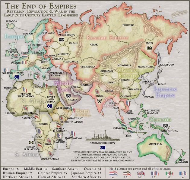
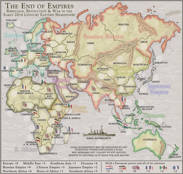
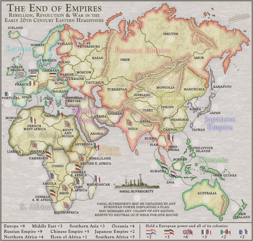
Colors
The colors are good. The inner glow you have on the different regions stands out well but does not overpower the look of the map. Flags seem easy enough to read and distinguish apart from each other. The legend is lacking in color but I will touch on that in more detail below.
The only things that are directly related to color on the actual map are the inner glows of the Chinese Empire, Southern Africa and So. Asia.
    -The Chinese blends too well into the base color of the map. It almost looks like there is not even a glow for that region.
    -So. Asia is very close to the Russian Empire color. I am not sure if this will be a problem for colorblind people
    -Southern Africa is hard to see and tends to blend in with the background sea color.
Here is a list of the colors you have now:
    Red-Russia
    Light Red-So. Asia
    Orange-Horn
    Light Yellow- Chinese
    Light Green-AU
    Cyan-Europe
    Blue-Japan
    Purple-Middle East
    Brown-N. Africa
    Gray-S. Africa
Maybe if you have more variation in the colors it will be easier to distinguish them (especially in the 3 areas I listed above)
    Dark Red or Burgundy-So. Asia
    Brighter Yellow to help stand out from base land color- Chinese
    Darker Gray or Mustard yellow similar to current Chinese-S. Africa
I think that these might help a bit. Plus I don’t think the yellow in Africa will be as bad as China since it is surrounded by gray ocean and not brown mountains.

Text
The region names on the map are easy to read and yet do not overpower the map. They seem to be there when you are looking for them but fade into the background when not interested. The territory names are also very easy to read. However (especially in Europe) some of the black ext blends in with the black territory borders (See Vilno, St. Petersburg, Sweden, etc) Just a suggestion but maybe a slight glow around the text to help break that up might look good. Not a big deal just a suggestion.

Title
I have no complaints on the title. It is simple, easily read, Conveys the purpose, theme and setting for the map. My one question is how you will name this map for the map select screen?

Army Circles
One of the first things I noticed on the map was how big your army circles were. I measured and I think they are 24 pxl. I first thought that they might not be needed at all but there are some really small territories. I think it is possible to get rid of them 100% by modifying the borders and relocating the flags and text of a few territories.
    -Move the Netherlands text and flag up-Room for 88
    -Move the Portugal border into Spain a bit- Room for 88
    -Move Liberia text down- Room for 88
    -On the smaller island territories, just enlarge the land mass a bit- Room for 88
I just think that getting rid of them will help out the maps look. But if that is not possible (for either 88 readability or 88 placements) then I suggest going to a 20 pxl radius circle. It still does the same job as a 24 pxl but is smaller and more easily fits.

Legend
The biggest thing I can say here is that it is too plain. While a player is able to read the text and find the corresponding bonus region on the map, there is still a sense to me that something is lacking. I would suggest adding the color of the bonus region to the text.
This could be done with an outer glow, a colored shape under the bonus value or maybe a colored line behind each name and bonus. Whatever it would turn out to be, I think adding the colors would help visually link the legend and the map.

Borders/Mountains
First I will talk over the regular black borders. Nothing big here. No major issues and barely any minor ones. The only thing I can see is that the borders up in the Scandinavian area do not touch the other border. Norway/Sweden border does not touch the Finland border and the Finland/St.Petersburg does not touch Norway. Like I said no big deal but I figured I would be thorough. Now onto the mountains.

First off the mountains are an important distinguishing feature that really helps the map out but at the same time I do not like how they look. Don’t get me wrong, I understand the purpose of them and I think that mountains need to be used but the implementation of them just does not feel right. Some of them just look like scars laid over the land (Eastern Russia and Australia). The mountains around China are very nice. I think they look good because they go from mountains to hills to flat land. The colors blend well and the entire image is integrated. The mountains I mentioned above just seen stuff on top of flat land. The ones in eastern Russia look good until the reddish bases don’t blend into the brown base of the map image. Same goes for the AU mountains too. I really think those should just be removed (I posted on that much earlier in the map development)
I would suggest that you take all names and colors and borders off of the map and try to make the mountains look integrated into the base image. Then once they look seamlessly integrated into the look, turn back on your other layers. That way colors and borders will not affect your mountain style.
Also it was mentioned earlier that there is no legend info explaining the mountains are impassable. I think that is needed as well.

Game Play
Game Play looks fine to me. I see no huge problems with it but....those of you who know me best do know that I am not the worlds best GP person. Actually I am not good at all. I can come up with ideas and such but implementation of the final bonuses and borders and such is not my cup of tea. Since that is the case I will not defer judgement to the others in the thread.

Additional Comments
One last thing and it does not really have to do with any area I discussed above but what is the area to the east of AMUR? It just seems like there is supposed to be another territory there. Visually there seems to be something missing.

Overall the map is great and should be a fun experience. I hope these suggestion/comments help and looking forward to hearing your response.

WM
Image
Major WidowMakers
 
Posts: 2774
Joined: Mon Nov 20, 2006 9:25 am
Location: Detroit, MI

PreviousNext

Return to The Atlas

Who is online

Users browsing this forum: No registered users