Conquer Club

War of the Triple Alliance

Care to peruse completed maps? Take a stroll through the Atlas.

Moderator: Cartographers

Forum rules
Please read the Community Guidelines before posting.

Re: War of the Triple Alliance; updates pg. 7 [D, Gp]

Postby oaktown on Tue Aug 26, 2008 8:57 pm

yeti_c wrote:At first I thought it was
Stars = Brazil
Suns = Argentina
But then Uruaguay has suns - and paraguay has stars.

Confused!

Well, Brazil and Paraguay both have stars in their flags, and both argentina and uruguay have suns. Trouble is that they don't correspond to the two 'sides' of the actual historical war. It'd probably make more sense to just go back to the old army circles, and do something else to indicate colors in the legend.
User avatar
Captain oaktown
 
Posts: 4451
Joined: Sun Dec 03, 2006 9:24 pm
Location: majorcommand

Re: War of the Triple Alliance; updates pg. 7 [D, Gp]

Postby yeti_c on Wed Aug 27, 2008 5:27 am

oaktown wrote:
yeti_c wrote:At first I thought it was
Stars = Brazil
Suns = Argentina
But then Uruaguay has suns - and paraguay has stars.

Confused!

Well, Brazil and Paraguay both have stars in their flags, and both argentina and uruguay have suns. Trouble is that they don't correspond to the two 'sides' of the actual historical war. It'd probably make more sense to just go back to the old army circles, and do something else to indicate colors in the legend.


Aha - I see - I missed that (tenuous) link... Hmmm - I'm unsure then - I think it might end up confusing people - especially with the gun in the legend that bears no resembelance in the map too?!

C.
Image
Highest score : 2297
User avatar
Lieutenant yeti_c
 
Posts: 9624
Joined: Thu Jan 04, 2007 9:02 am

Re: War of the Triple Alliance; updates pg. 7 [D, Gp]

Postby oaktown on Wed Aug 27, 2008 9:04 am

yeti_c wrote:Aha - I see - I missed that (tenuous) link... Hmmm - I'm unsure then - I think it might end up confusing people - especially with the gun in the legend that bears no resembelance in the map too?!

C.

Yeah, and I just kinda think that the guns and suns look a bit cartoonish.
User avatar
Captain oaktown
 
Posts: 4451
Joined: Sun Dec 03, 2006 9:24 pm
Location: majorcommand

Re: War of the Triple Alliance; update pg. 9 [D, Gp]

Postby lt_oddball on Thu Aug 28, 2008 4:40 am

first time stumbling in on this map.
I like the historic setting..buttah..If you say Paraguay lost -what- more than 70% of its country...then where can I find "Paraguay" on the map ????
With difficulty(!) I find a couple of small provinces in yellow with a transparent "Para" ... Is that supposed to be the great country that took on Brazil and Argentina ?!?!?!

[-X

edit: ah, wikipedia; it 's not huge chunks of territory(+people) that was lost..but the population.. :cry:

still, from http://www.heritageantiquemaps.com/Gall ... Brazil.jpg we see that Paraguay was a bit bigger originally: including Chaco and Manso territories on this map.
Barbarus hic ego sum, quia non intellegor ulli.
User avatar
Major lt_oddball
 
Posts: 364
Joined: Mon Mar 05, 2007 11:17 am
Location: Fortress Europe

Re: War of the Triple Alliance; update pg. 9 [D, Gp]

Postby oaktown on Sat Aug 30, 2008 2:36 am

lt_oddball wrote:still, from http://www.heritageantiquemaps.com/Gall ... Brazil.jpg we see that Paraguay was a bit bigger originally: including Chaco and Manso territories on this map.

check your dates and facts, lt... Paraguay lost over half of it's pre-way population (by some counts) but it lost very little land. In fact, a few years after the war the US brokered an agreement that actually gave Paraguay more land, pushing its borders out to the size it is today.
User avatar
Captain oaktown
 
Posts: 4451
Joined: Sun Dec 03, 2006 9:24 pm
Location: majorcommand

Re: War of the Triple Alliance; update pg. 9 [D, Gp]

Postby lt_oddball on Sat Aug 30, 2008 5:38 pm

oaktown wrote: In fact, a few years after the war the US brokered an agreement that actually gave Paraguay more land, pushing its borders out to the size it is today.

why is that ? (mighty interesting) How was the US involved in this?, and why supporting a lost aggressor (as Paraguay started the attacks)..and why would Brazil and Argentina accept a (quite remote) foreign body to intervene against their interests ??
Barbarus hic ego sum, quia non intellegor ulli.
User avatar
Major lt_oddball
 
Posts: 364
Joined: Mon Mar 05, 2007 11:17 am
Location: Fortress Europe

Re: War of the Triple Alliance; update pg. 9 [D, Gp]

Postby edbeard on Sat Aug 30, 2008 5:43 pm

I understand the reasoning behind making Gran Chaco +1 but from a gameplay pov, +2 makes more sense
User avatar
Lieutenant edbeard
 
Posts: 2501
Joined: Thu Mar 29, 2007 12:41 am

Re: War of the Triple Alliance; update pg. 9 [D, Gp]

Postby lt_oddball on Mon Sep 01, 2008 8:58 am

Could you colour and broaden the rio plata such that it stands out and becomes INSTANTLY clear (to noobs!) that it is a map-highway to attack one capitol to the next. Likewise give each capitol a much more colourfull marker.
My experience tells me that a lot of noobs or otherwise simple minded players do NOT read the legend text and thus gamejoy is spoiled.
("you fool , didnt you see" "shut up you prank, mind yr own business" "moron"..etc..).

Paraguay is still only "Para" ?

Since the history tells us that the paraguayan army was so much stronger (in numbers and in experience) than the initial Brazilian and Argentinian armies, shouldn't you device something in this map that improves the position of the paraguayan bonusarea ?
Now it is very quickly over and out for the one that holds paraguay in the early stage of the game (in center, attacks from all directions, including all capitols)..maybe you should give paraguay a +5 bonus ?
Barbarus hic ego sum, quia non intellegor ulli.
User avatar
Major lt_oddball
 
Posts: 364
Joined: Mon Mar 05, 2007 11:17 am
Location: Fortress Europe

Re: War of the Triple Alliance; updates pg. 7 [D, Gp]

Postby iancanton on Sat Sep 06, 2008 8:08 pm

whitestazn88 wrote:if there was a color i'd change, it would be the purple to something else

why not have sky blue for argentina, as in the national flag, rather than purple? brasil sudeste can be made a middle green instead, deeper than mato grosso.

ian. :)
User avatar
Colonel iancanton
Foundry Foreman
Foundry Foreman
 
Posts: 2424
Joined: Fri Jun 01, 2007 5:40 am
Location: europe

Re: War of the Triple Alliance; update pg. 9 [D, Gp]

Postby oaktown on Sun Sep 28, 2008 9:55 pm

Click image to enlarge.
image


It was either work on this map or put it on vacation, so here it is.

Changes reflect most recent comments:
ā€¢ Argentina is blue;
ā€¢ Brazil stars changed to diamonds to better reflect national identity apart from Paraguay;
ā€¢ the river is a bit wider, but I may go even more so to help point that it is navigable.

I considered pumping up the paraguay bonus, but I think+3 for a four territory region is already pretty good on this map; Gran Chaco I really want to keep low since it was just frontier at the time and not of much value to anybody other than prospectors who went in, mined, panned, and decided only later that it wasn't worth anything.
User avatar
Captain oaktown
 
Posts: 4451
Joined: Sun Dec 03, 2006 9:24 pm
Location: majorcommand

Re: War of the Triple Alliance; fianlly an update pg. 9 [D, Gp]

Postby mibi on Sun Sep 28, 2008 10:14 pm

looks great.. thought something is off that makes the context a little ... off.. I think its the sea color and the non playable land area are so close it just looks weird.
User avatar
Captain mibi
 
Posts: 3350
Joined: Thu Mar 01, 2007 8:19 pm
Location: The Great State of Vermont

Re: War of the Triple Alliance; fianlly an update pg. 9 [D, Gp]

Postby oaktown on Sun Sep 28, 2008 10:29 pm

mibi wrote:I think its the sea color and the non playable land area are so close it just looks weird.

Well hell, that's easy enough to fix...

Click image to enlarge.
image
User avatar
Captain oaktown
 
Posts: 4451
Joined: Sun Dec 03, 2006 9:24 pm
Location: majorcommand

Re: War of the Triple Alliance; new update pg. 10 [D, Gp]

Postby pamoa on Mon Sep 29, 2008 3:39 am

Corrientes territory is still a problem, it's really not easy to understand how it's working. Maybe put a bridge or a kind of link across the river.
Another suggestion is to reorder in a more graphically logical order your bonus list (left to right,top to bottom):
    Gran Chaco
    Paraguay
    Argentina
    Uruguay

    Mato Grosso
    Goyaz
    Brasil Este
    Brazil Sudeste

    Rio Grande do Sul
De gueules Ć  la tour d'argent ouverte, crĆ©nelĆ©e de trois piĆØces, sommĆ©e d'un donjon ajourĆ©, crĆ©nelĆ© de deux piĆØces
Gules an open tower silver, crenellated three parts, topped by a apertured turret, crenellated two parts
User avatar
Cadet pamoa
 
Posts: 1242
Joined: Sat Sep 01, 2007 3:18 am
Location: Confederatio Helvetica

Re: War of the Triple Alliance; new update pg. 10 [D, Gp]

Postby yeti_c on Mon Sep 29, 2008 8:34 am

Would like to see the bonus table laid out a bit nicer - consider aligning everything vertcially.

C.
Image
Highest score : 2297
User avatar
Lieutenant yeti_c
 
Posts: 9624
Joined: Thu Jan 04, 2007 9:02 am

Re: War of the Triple Alliance; new update pg. 10 [D, Gp]

Postby oaktown on Mon Sep 29, 2008 8:41 am

moving goyaz so that the diamonds are all together would make sense... maybe in the left column and lining up the Rio Grande diamond with them would make it easier on the eye.

Corrientes - what if i lightly shaded that stretch of the river the same color as the territory?
User avatar
Captain oaktown
 
Posts: 4451
Joined: Sun Dec 03, 2006 9:24 pm
Location: majorcommand

Re: War of the Triple Alliance; new update pg. 10 [D, Gp]

Postby pamoa on Mon Sep 29, 2008 10:02 am

oaktown wrote:Corrientes - what if i lightly shaded that stretch of the river the same color as the territory?

Why not give a try
De gueules Ć  la tour d'argent ouverte, crĆ©nelĆ©e de trois piĆØces, sommĆ©e d'un donjon ajourĆ©, crĆ©nelĆ© de deux piĆØces
Gules an open tower silver, crenellated three parts, topped by a apertured turret, crenellated two parts
User avatar
Cadet pamoa
 
Posts: 1242
Joined: Sat Sep 01, 2007 3:18 am
Location: Confederatio Helvetica

Re: War of the Triple Alliance; new update pg. 10 [D, Gp]

Postby oaktown on Mon Sep 29, 2008 9:26 pm

Click image to enlarge.
image


In this update:
I've played around with shading in the river through Corrientes, and lined up the Brazil regions in the legend... I tried lining up the right column as well, but it looked better right justified.

Hmm, I seem to have lost the period (.) at the end of the text... noted.

Also just noticed that the darker land screwed up the image of the soldiers a bit.
User avatar
Captain oaktown
 
Posts: 4451
Joined: Sun Dec 03, 2006 9:24 pm
Location: majorcommand

Re: War of the Triple Alliance; new update pg. 10 [D, Gp]

Postby edbeard on Mon Sep 29, 2008 10:20 pm

Gran Chaco +2? I understand the significance of having it +1 but that's going to be lost on everyone playing. plus, Uruguay is easier to hold and has a higher bonus. mad/confused players a comin'


I'm glad you changed the start colour for Paraguay in the legend so I don't have to point it out and instead I can point out that I'm not pointing it out so people will be like, "that guy is smart but not nitpicky." Unfortunately they'll probably call me "egotistical," "insecure," and "weird."
User avatar
Lieutenant edbeard
 
Posts: 2501
Joined: Thu Mar 29, 2007 12:41 am

Re: War of the Triple Alliance; new update pg. 10 [D, Gp]

Postby pamoa on Tue Sep 30, 2008 6:49 am

Corrientes: better but what you can do is remove the black line along the river, so it does seems you have two territ.

Any chance you reorder the bonus list as following
    Mato Grosso
    Goyaz
    Brasil Este
    Brazil Sudeste
    Rio Grande do Sul

    Gran Chaco
    Paraguay
    Argentina
    Uruguay
De gueules Ć  la tour d'argent ouverte, crĆ©nelĆ©e de trois piĆØces, sommĆ©e d'un donjon ajourĆ©, crĆ©nelĆ© de deux piĆØces
Gules an open tower silver, crenellated three parts, topped by a apertured turret, crenellated two parts
User avatar
Cadet pamoa
 
Posts: 1242
Joined: Sat Sep 01, 2007 3:18 am
Location: Confederatio Helvetica

Re: War of the Triple Alliance; new update pg. 10 [D, Gp]

Postby TaCktiX on Tue Sep 30, 2008 7:46 am

I like the new graininess to the map a LOT. Adds a little bit of "I just dug this out of my father's trunk upstairs" flair to it.

In regards to Corrientes, that first R disappears behind the black line. Maybe make the line a little bit gray to match with the river proper? The text going through the entire thing should make that it's one territory very obvious.

Agreed on the Gran Chaco to +2 petition.
User avatar
Corporal 1st Class TaCktiX
 
Posts: 2392
Joined: Mon Dec 17, 2007 8:24 pm
Location: Rapid City, SD

Re: War of the Triple Alliance; new update pg. 10 [D, Gp]

Postby gimil on Wed Oct 01, 2008 9:11 am

I don't know if I am the only one but I don't much like the dimond shaped army cricles oaktown. If their anything else that could be given a try?
What do you know about map making, bitch?

natty_dread wrote:I was wrong


Top Score:2403
User avatar
Corporal 1st Class gimil
 
Posts: 8599
Joined: Sat Mar 03, 2007 12:42 pm
Location: United Kingdom (Scotland)

Re: War of the Triple Alliance; new update pg. 10 [D, Gp]

Postby oaktown on Wed Oct 01, 2008 11:27 pm

gimil wrote:I don't know if I am the only one but I don't much like the dimond shaped army cricles oaktown.

You're the only one. ;) They look funny now, but I think they'll look better with army counts, but to properly drop in army counts I'll need to do the XML.

Oh, look what I found!
(no coordinates yet)
Code: Select all
<?xml version="1.0"?>
<map>
   <title>Alliance</title>
   <smallwidth>600</smallwidth>
   <smallheight>600</smallheight>
   <largewidth>800</largewidth>
   <largeheight>800</largeheight>
   <filetype>jpg</filetype>

   <continent>
      <name>Mato Grosso</name>
      <bonus>6</bonus>
      <components>
         <territory>Balsamao</territory>
         <territory>Cordillera Gera</territory>
         <territory>Rio Tapajos</territory>
         <territory>Lapa</territory>
         <territory>Diamantina</territory>
         <territory>Cuiaba</territory>
         <territory>Carumb&#x00E1</territory>
         <territory>Miranda</territory>
         <territory>Dourados</territory>
      </components>
   </continent>

   <continent>
      <name>Goyaz</name>
      <bonus>2</bonus>
      <components>
         <territory>Rio Araguaia</territory>
         <territory>Tocantins</territory>   
         <territory>Ciudad Goyaz</territory>
         <territory>Campinas</territory>
         </components>
   </continent>

   <continent>
      <name>Gran Chaco</name>
      <bonus>2</bonus>
      <components>
         <territory>Bolivian Claim</territory>
         <territory>Chaco Boreal</territory>
         <territory>Llanos de Manso</territory>
      </components>
   </continent>

   <continent>
      <name>Brasil Este</name>
      <bonus>4</bonus>
      <components>
         <territory>Pernambuco</territory>
         <territory>Alagoas</territory>
         <territory>Sergipe</territory>
         <territory>Bahia Oriental</territory>
         <territory>Bahia Ocidental</territory>
         <territory>Porto Seguro</territory>
      </components>
   </continent>

   <continent>
      <name>Paraguay</name>
      <bonus>3</bonus>
      <components>
         <territory>S. Ignacio</territory>
         <territory>Igatim</territory>
         <territory>Bovi</territory>
         <territory>Asuncion</territory>
      </components>
   </continent>
   
   <continent>
      <name>Brasil Sudeste</name>
      <bonus>4</bonus>
      <components>
         <territory>Triangulo Mineiro</territory>
         <territory>Villa Rica</territory>
         <territory>Rio de Janeiro</territory>
         <territory>Minas Novis</territory>
         <territory>Espiritu Santo</territory>
      </components>
   </continent>
   
   <continent>
      <name>Rio Grande do Sul</name>
      <bonus>4</bonus>
      <components>
         <territory>S&#x00E3o Paulo</territory>
         <territory>Curtiba</territory>
         <territory>Parana</territory>
         <territory>S. Catharina</territory>
         <territory>S&#x00E3o Pedro</territory>
         <territory>Porto Alegre</territory>
      </components>
   </continent>
   
   <continent>
      <name>Uruguay</name>
      <bonus>2</bonus>
      <components>
         <territory>Belen</territory>
         <territory>Valles</territory>
         <territory>Montevideo</territory>
      </components>
   </continent>

   <continent>
      <name>Republica Argentina</name>
      <bonus>6</bonus>
      <components>
         <territory>Salta</territory>
         <territory>Tucuman</territory>
         <territory>Catamarca</territory>
         <territory>Corrientes</territory>
         <territory>Entre Rios</territory>
         <territory>Santiago</territory>
         <territory>Cordova</territory>
         <territory>Mendoza</territory>
         <territory>San Luis</territory>
         <territory>Puelches</territory>
         <territory>Buenos Ayres</territory>
      </components>
   </continent>


   <territory>
      <name>Rio de la Plata</name>
      <borders>
         <border>Rio de Janeiro</border>
         <border>Montevideo</border>
         <border>Buenos Ayres</border>
         <border>Asuncion</border>
      </borders>
      <coordinates>
      </coordinates>
   </territory>

   <territory>
      <name>Balsamao</name>
      <borders>
         <border>Rio Tapajos</border>
         <border>Cordillera Gera</border>
      </borders>
      <coordinates>
      </coordinates>
   </territory>
   <territory>
      <name>Cordillera Gera</name>
      <borders>
         <border>Balsamao</border>
         <border>Rio Tapajos</border>
         <border>Diamantino</border>
      </borders>
      <coordinates>
      </coordinates>
   </territory>
   <territory>
      <name>Rio Tapajos</name>
      <borders>
         <border>Balsamao</border>
         <border>Cordillera Gera</border>
         <border>Diamantino</border>
         <border>Lapa</border>
      </borders>
      <coordinates>
      </coordinates>
   </territory>
   <territory>
      <name>Diamantino</name>
      <borders>
         <border>Cordillera Gera</border>
         <border>Rio Tapajos</border>
         <border>Carumb&#x00E1</border>
         <border>Lapa</border>
         <border>Cuiaba</border>
      </borders>
      <coordinates>
      </coordinates>
   </territory>
   <territory>
      <name>Lapa</name>
      <borders>
         <border>Rio Tapajos</border>
         <border>Diamantino</border>
         <border>Ciudad Goyaz</border>
         <border>Cuiaba</border>         
      </borders>
      <coordinates>
      </coordinates>
   </territory>
   <territory>
      <name>Cuiaba</name>
      <borders>
         <border>Diamantino</border>
         <border>Miranda</border>
         <border>Carumb&#x00E1</border>
         <border>Lapa</border>         
      </borders>
      <coordinates>
      </coordinates>
   </territory>
   <territory>
      <name>Miranda</name>
      <borders>
         <border>Chaco Borreal</border>      
         <border>Carumb&#x00E1</border>      
         <border>Cuiaba</border>
         <border>Dourados</border>
         <border>Bolivian Claim</border>
      </borders>
      <coordinates>
      </coordinates>
   </territory>
   <territory>
      <name>Dourados</name>
      <borders>
         <border>Miranda</border>
         <border>Campinas</border>
         <border>Tri&#x00E1ngulo Mineiro</border>
         <border>Igatim</border>
         <border>S. Ignacio</border>
      </borders>
      <coordinates>
      </coordinates>
   </territory>
   
   
   <territory>
      <name>Rio Araguaia</name>
      <borders>
         <border>Tocantins</border>
         <border>Ciudad Goyaz</border>
      </borders>
      <coordinates>
      </coordinates>
   </territory>
   <territory>
      <name>Tocantins</name>
      <borders>
         <border>Rio Araguaia</border>
         <border>Ciudad Goyaz</border>
      </borders>
      <coordinates>
      </coordinates>
   </territory>
   <territory>
      <name>Ciudad Goyaz</name>
      <borders>
         <border>Rio Araguaia</border>
         <border>Tocantins</border>
         <border>Campinas</border>
         <border>Lapa</border>
         <border>Bahia Ocidental</border>
      </borders>
      <coordinates>
      </coordinates>
   </territory>
   <territory>
      <name>Campinas</name>
      <borders>
         <border>Dourados</border>
         <border>Ciudad Goyaz</border>
         <border>Tri&#x00E1ngulo Mineiro</border>   
      </borders>
      <coordinates>
      </coordinates>
   </territory>   
   
   <territory>
      <name>Bahia Ocidental</name>
      <borders>
         <border>Pernambuco</border>
         <border>Bahia Oriental</border>
         <border>Ciudad Goyaz</border>
         <border>Tri&#x00E1ngulo Mineiro</border>   
      </borders>
      <coordinates>
      </coordinates>
   </territory>
   <territory>
      <name>Pernambuco</name>
      <borders>
         <border>Alagoas</border>
         <border>Bahia Ocidental</border>
      </borders>
      <coordinates>
      </coordinates>
   </territory>
   <territory>
      <name>Alagoas</name>
      <borders>
         <border>Pernambco</border>
         <border>Sergipe</border>
      </borders>
      <coordinates>
      </coordinates>
   </territory>
   <territory>
      <name>Sergipe</name>
      <borders>
         <border>Alagoas</border>
         <border>Bahia Oriental</border>
      </borders>
      <coordinates>
      </coordinates>
   </territory>
   <territory>
      <name>Bahia Oriental</name>
      <borders>
         <border>Sergipe</border>
         <border>Bahia Ocidental</border>
         <border>Porto Seguro</border>
         <border>Minas Novas</border>
      </borders>
      <coordinates>
      </coordinates>
   </territory>
   <territory>
      <name>Porto Seguro</name>
      <borders>
         <border>Bahia Oriental</border>
         <border>Minas Novas</border>
         <border>Espiritu Santo</border>
      </borders>
      <coordinates>
      </coordinates>
   </territory>   
   
   
   <territory>
      <name>Minas Novas</name>
      <borders>
         <border>Villa Rica</border>
         <border>Espiritu Santo</border>
         <border>Rio de Janeiro</border>
         <border>Bahia Oriental</border>
         <border>Porto Seguro</border>
      </borders>
      <coordinates>
      </coordinates>
   </territory>
   <territory>
      <name>Espiritu Santo</name>
      <borders>
         <border>Minas Novas</border>
         <border>Rio de Janeiro</border>
         <border>Porto Seguro</border>
      </borders>
      <coordinates>
      </coordinates>
   </territory>
   <territory>
      <name>Rio de Janeiro</name>
      <borders>
         <border>Villa Rica</border>
         <border>Minas Novas</border>
         <border>Espiritu Santo</border>
         <border>S&#x00E3o Paulo</border>
         <border>Rio de la Plata</border>         
      </borders>
      <coordinates>
      </coordinates>
   </territory>
   <territory>
      <name>Villa Rica</name>
      <borders>
         <border>Minas Novis</border>
         <border>Espiritu Santo</border>
         <border>Rio de Janeiro</border>
         <border>Triangulo Mineiro</border>
      </borders>
      <coordinates>
      </coordinates>
   </territory>
   <territory>
      <name>Triangulo Mineiro</name>
      <borders>
         <border>Villa Rica</border>
         <border>Campinas</border>
         <border>Bahia Ocidental</border>
         <border>Dourados</border>
      </borders>
      <coordinates>
      </coordinates>
   </territory>   
   
   
   <territory>
      <name>Bolivian Claim</name>
      <borders>
         <border>Chaco Boreal</border>
         <border>Llanos de manso</border>
         <border>Carumb&#x00E1</border>
         <border>Miranda</border>
         <border>Salta</border>
      </borders>
      <coordinates>
      </coordinates>
   </territory>
   <territory>
      <name>Chaco Boreal</name>
      <borders>
         <border>Bolivian Claim</border>
         <border>Llanos de Manso</border>
         <border>Miranda</border>
         <border>S. Ignacio</border>
      </borders>
      <coordinates>
      </coordinates>
   </territory>
   <territory>
      <name>Llanos de Manso</name>
      <borders>
         <border>Chaco Boreal</border>
         <border>Bolivian Claim</border>
         <border>Salta</border>
         <border>Corrientes</border>
      </borders>
      <coordinates>
      </coordinates>
   </territory>
   
   
   <territory>
      <name>S. Ignacio</name>
      <borders>
         <border>Asuncion</border>
         <border>Igatim</border>
         <border>Miranda</border>
         <border>Dourados</border>
         <border>Chaco Boreal</border>
      </borders>
      <coordinates>
      </coordinates>
   </territory>   
   <territory>
      <name>Igatim</name>
      <borders>
         <border>S. Ignacio</border>
         <border>Asuncion</border>
         <border>Bovi</border>
         <border>Dourados</border>
         <border>Parana</border>
      </borders>
      <coordinates>
      </coordinates>
   </territory>   
   <territory>
      <name>Bovi</name>
      <borders>
         <border>Igatim</border>
         <border>Asuncion</border>
      </borders>
      <coordinates>
      </coordinates>
   </territory>   
   <territory>
      <name>Asuncion</name>
      <borders>
         <border>S. Ignacio</border>
         <border>Igatim</border>
         <border>Bovi</border>
         <border>Corrientes</border>
         <border>Rio de la Plata</border>
      </borders>
      <coordinates>
      </coordinates>
   </territory>


   <territory>
      <name>S&#x00E3o Paulo</name>
      <borders>
         <border>Curitiba</border>
         <border>Parana</border>
         <border>Rio de Janeiro</border>
      </borders>
      <coordinates>
      </coordinates>
   </territory>
   <territory>
      <name>Curitiba</name>
      <borders>
         <border>S&#x00E3o Paulo</border>
         <border>Parana</border>
         <border>S. Catharina</border>
      </borders>
      <coordinates>
      </coordinates>
   </territory>
   <territory>
      <name>Parana</name>
      <borders>
         <border>S&#x00E3o Paulo</border>
         <border>Curitiba</border>
         <border>S. Catharina</border>
         <border>S&#x00E3o Pedro</border>
         <border>Igatim</border>
      </borders>
      <coordinates>
      </coordinates>
   </territory>
   <territory>
      <name>S&#x00E3o Pedro</name>
      <borders>
         <border>Parana</border>
         <border>S. Catharina</border>
         <border>Porto Alegre</border>
         <border>Belen</border>
         <border>Valles</border>
      </borders>
      <coordinates>
      </coordinates>
   </territory>
   <territory>
      <name>Porto Alegre</name>
      <borders>
         <border>S. Catharina</border>
         <border>S&#x00E3o Pedro</border>
      </borders>
      <coordinates>
      </coordinates>
   </territory>   
   <territory>
      <name>S. Catharina</name>
      <borders>
         <border>Parana</border>
         <border>Curitiba</border>         
         <border>Porto Alegre</border>
         <border>S&#x00E3o Pedro</border>
      </borders>
      <coordinates>
      </coordinates>
   </territory>
   
   <territory>
      <name>Valles</name>
      <borders>
         <border>S&#x00E3o Pedro</border>
         <border>Belen</border>
         <border>Montevideo</border>
      </borders>
      <coordinates>
      </coordinates>
   </territory>
   <territory>
      <name>Belen</name>
      <borders>
         <border>Valles</border>
         <border>Montevideo</border>
         <border>S&#x00E3o Pedro</border>
      </borders>
      <coordinates>
      </coordinates>
   </territory>   
   <territory>
      <name>Montevideo</name>
      <borders>
         <border>Belen</border>
         <border>Valles</border>         
         <border>Rio de la Plata</border>
      <coordinates>
      </coordinates>
   </territory>

   <territory>
      <name>Buenos Ayres</name>
      <borders>
         <border>Cordova</border>
         <border>San Luis</border>         
         <border>Rio de la Plata</border>
      <coordinates>
      </coordinates>
   </territory>
   <territory>
      <name>San Luis</name>
      <borders>
         <border>Buenos Ayres</border>
         <border>Cordova</border>         
         <border>Puelches</border>
         <border>Mendoza</border>
      <coordinates>
      </coordinates>
   </territory>
   <territory>
      <name>Puelches</name>
      <borders>
         <border>San Luis</border>
         <border>Mendoza</border>
      <coordinates>
      </coordinates>
   </territory>
      <territory>
      <name>Mendoza</name>
      <borders>
         <border>San Luis</border>
         <border>Cordova</border>         
         <border>Puelches</border>
         <border>Catamarca</border>
      <coordinates>
      </coordinates>
   </territory>
   <territory>
      <name>Cordova</name>
      <borders>
         <border>Buenos Ayres</border>
         <border>San Luis</border>         
         <border>Santiago</border>
         <border>Mendoza</border>
         <border>Catamarca</border>
      <coordinates>
      </coordinates>
   </territory>
   <territory>
      <name>Catamarca</name>
      <borders>
         <border>Cordova</border>
         <border>Tucuman</border>         
         <border>Santiago</border>
         <border>Mendoza</border>
         <border>Salta</border>
      <coordinates>
      </coordinates>
   </territory>   
   <territory>
      <name>Santiago</name>
      <borders>
         <border>Cordova</border>
         <border>Tucuman</border>         
         <border>Catamarca</border>
         <border>Corrientes</border>
      <coordinates>
      </coordinates>
   </territory>   
   <territory>
      <name>Tucuman</name>
      <borders>
         <border>Corrientes</border>
         <border>Salta</border>         
         <border>Catamarca</border>
         <border>Corrientes</border>
      <coordinates>
      </coordinates>
   </territory>   
   <territory>
      <name>Salta</name>
      <borders>
         <border>Corrientes</border>
         <border>Tucuman</border>         
         <border>Catamarca</border>
         <border>Llanos de Manso</border>
         <border>Bolivian Claim</border>
      <coordinates>
      </coordinates>
   </territory>   
   <territory>
      <name>Corrientes</name>
      <borders>
         <border>Entre Rios</border>
         <border>Salta</border>         
         <border>Tucuman</border>
         <border>Santiago</border>
      <coordinates>
      </coordinates>
   </territory>
   <territory>
      <name>Entre Rios</name>
      <borders>
         <border>Corrientes</border>
      <coordinates>
      </coordinates>
   </territory>
   
</map>
User avatar
Captain oaktown
 
Posts: 4451
Joined: Sun Dec 03, 2006 9:24 pm
Location: majorcommand

Re: War of the Triple Alliance; new update pg. 10 [D, Gp]

Postby InkL0sed on Wed Oct 01, 2008 11:38 pm

I don't like the diamonds either. I like the sun thingies much better.
User avatar
Lieutenant InkL0sed
 
Posts: 2370
Joined: Sat Jun 23, 2007 4:06 pm
Location: underwater

Re: War of the Triple Alliance; new update pg. 10 [D, Gp]

Postby edbeard on Wed Oct 01, 2008 11:54 pm

I like them. I recognized them from the Brazilian flag immediately.

I didn't quite get how the sun circles fit with this era or the area they're used. The star-circles seemed generic. different from regular circles but no point really.
Last edited by edbeard on Wed Oct 01, 2008 11:55 pm, edited 1 time in total.
User avatar
Lieutenant edbeard
 
Posts: 2501
Joined: Thu Mar 29, 2007 12:41 am

Re: War of the Triple Alliance; new update pg. 10 [D, Gp]

Postby oaktown on Wed Oct 01, 2008 11:54 pm

Click image to enlarge.
image


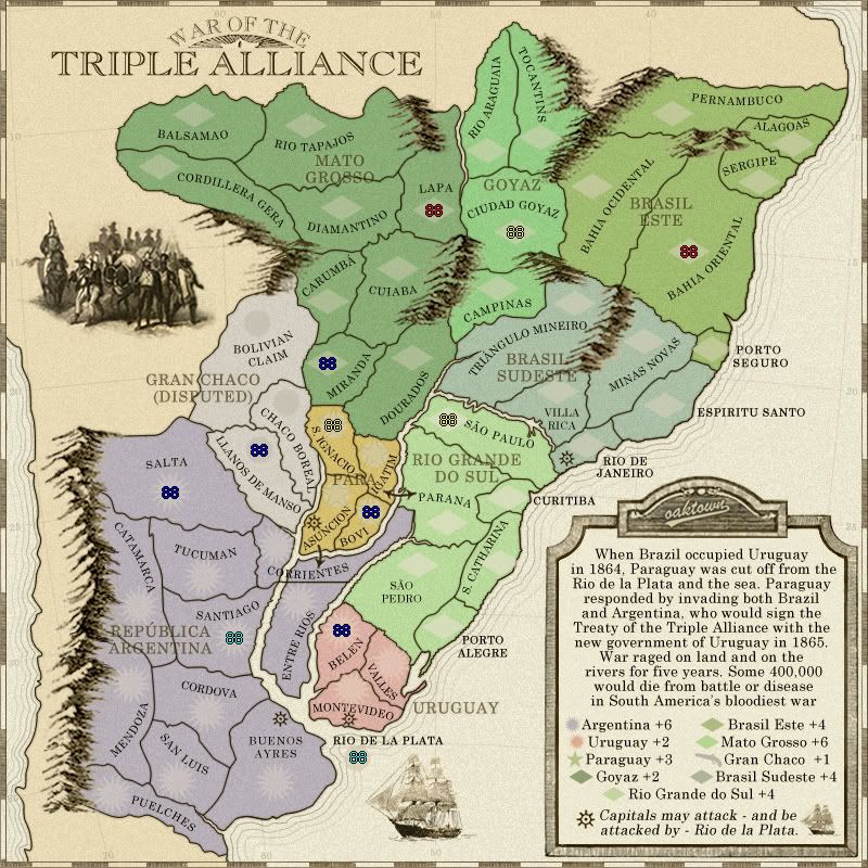
Gimil, here it is with additional army counts... I hope you agree that once the numbers are there the diamonds don't pop out as much. Personally, I think just about all army circles on every map look bad until the numbers are placed - they just clutter up an otherwise nice piece of work.

pamoa wrote:Corrientes: better but what you can do is remove the black line along the river, so it does seems you have two territ.

Right, I softened up the river's edges a bit. I've also widened the rivers throughout a touch.

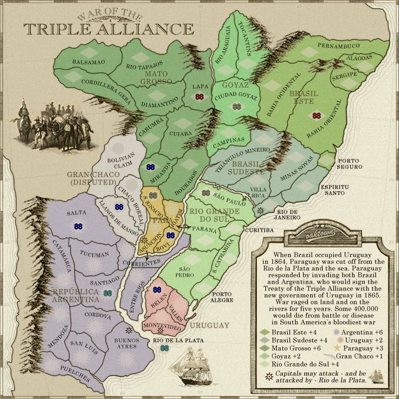
pamoa wrote:Any chance you reorder the bonus list as following
    Mato Grosso
    Goyaz
    Brasil Este
    Brazil Sudeste
    Rio Grande do Sul

    Gran Chaco
    Paraguay
    Argentina
    Uruguay

They are listed the way they are because it's how they fit - longest region title on the left is paired up with the shortest on the right. If I went with the above listings, I'd have to drop the font size down considerably,

TaCktiX wrote:In regards to Corrientes, that first R disappears behind the black line. Maybe make the line a little bit gray to match with the river proper? The text going through the entire thing should make that it's one territory very obvious.

Fixed, I hope.

TaCktiX wrote:Agreed on the Gran Chaco to +2 petition.

Alright, Gran Chaco is +2... personally I like making it something of a wasteland (which it was) and I'd rather see it with no bonus, as it began, but from a strictly gameplay perspective it makes more sense as a +2.
User avatar
Captain oaktown
 
Posts: 4451
Joined: Sun Dec 03, 2006 9:24 pm
Location: majorcommand

PreviousNext

Return to The Atlas

Who is online

Users browsing this forum: No registered users