Page 2 of 22

Re: A Real World Map v1p1 gameplay

PostPosted: Tue Jul 15, 2008 2:05 am
by whitestazn88
so i suppose all this supposing was useless without a real working image?

Re: A Real World Map v1p1 gameplay

PostPosted: Tue Jul 15, 2008 2:16 am
by edbeard
well if you were only concerned about graphics then yes it was a waste of your time. I did say on the map itself that these weren't the real graphics and me asking for an artist on there as well is another clue about that.

the draft was done to talk gameplay which we've done a bit. the discussion has affirmed my belief in the gameplay setup though. but, you're only one person and more minds are needed to settle it.

Re: A Real World Map v1p1 gameplay

PostPosted: Tue Jul 15, 2008 2:23 am
by oaktown
personally I never like it when folks put the arctic/antarctic in their maps... when has a nation ever used the south pole to transport armies, or given a rat's ass about controlling it? e.g. World 2.0. [-X

Re: A Real World Map v1p1 gameplay

PostPosted: Tue Jul 15, 2008 2:28 am
by whitestazn88
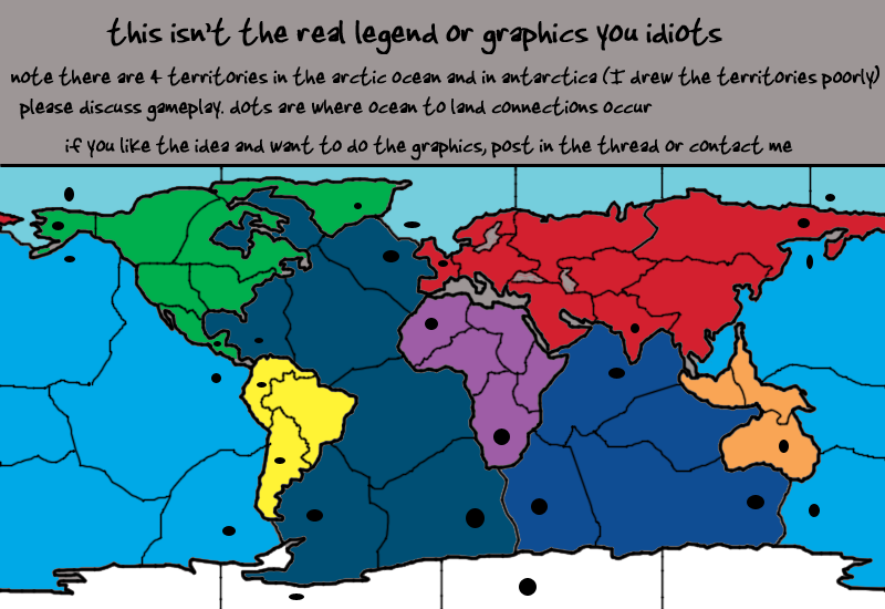
oaktown wrote:personally I never like it when folks put the arctic/antarctic in their maps... when has a nation ever used the south pole to transport armies, or given a rat's ass about controlling it? e.g. World 2.0. [-X


technically, its world 2.1...

secondly, it may never be used to transport armies, but many countries nowadays put a big stake in both poles for the research, although thats not really part of the gameplay of this map.

they are also important if you want to have a real map, as edbeard says he does

Re: A Real World Map v1p1 gameplay

PostPosted: Tue Jul 15, 2008 2:32 am
by edbeard
well the arctic was important to the soviets and their submarines. Didn't you watch 'The Hunt for the Red October' ?


Antarctica isn't really important but it'd feel like a waste not having it. It'd cut down on southern borders for oceans though. It's only included on two of the four 'world' maps we have here. It makes sense in both Extreme Global Warming and World 2.1 for different reasons. EGW because it'd be habitable after the extreme warming. World 2.1 because you NEED a southern attack route (I don't get the 0 bonus though).

Here it's not needed but I think it's a nice touch. Another small continent and if I'm including every other part of the world, why not Antarctica?


The 'real world' title was both used as a way to get people to look at the thread and to describe the lack of a map utilizing both land and sea on the whole world scale. It's not technically meant to say I'm making a 'real' map of the world.

Re: A Real World Map v1p1 gameplay

PostPosted: Mon Jul 21, 2008 6:15 pm
by whitestazn88
any updates coming soon?

Re: A Real World Map v1p1 gameplay

PostPosted: Mon Jul 21, 2008 6:21 pm
by Androidz
You must add big Greenland to your map:O

Re: A Real World Map v1p1 gameplay

PostPosted: Mon Jul 21, 2008 6:28 pm
by edbeard
Androidz wrote:You must add big Greenland to your map:O


it's there. it's the big green mess northeast of North America

it's based on this map http://www.fabiovisentin.com/world_map/ ... ld_map.jpg

Re: A Real World Map v1p1 gameplay

PostPosted: Mon Jul 21, 2008 6:33 pm
by Androidz
edbeard wrote:
Androidz wrote:You must add big Greenland to your map:O


it's there. it's the big green mess northeast of North America

it's based on this map http://www.fabiovisentin.com/world_map/ ... ld_map.jpg


hehe i didint see it on your map but now i do:D. im must be blind anyway when giveing bonus for greenland make sure it is a part of denmark;)

Re: A Real World Map v1p1 gameplay

PostPosted: Fri Jul 25, 2008 5:05 pm
by whitestazn88
so, we getting any updates soon ed?

Re: A Real World Map v1p1 gameplay

PostPosted: Fri Jul 25, 2008 5:12 pm
by Androidz
To make it even more intresting. Is to make an old Version of the the World map. When the roman empire was at it largest, or Prussia. or something else....

Re: A Real World Map v1p1 gameplay

PostPosted: Fri Jul 25, 2008 5:16 pm
by whitestazn88
no way man... an old version of the world map would be ineffective, as he would have to accurately portray the poor means of travel on water... which would make holding ocean territs extremely easy

Re: A Real World Map v1p1 gameplay

PostPosted: Fri Jul 25, 2008 5:20 pm
by Androidz
i dont think it will be as you say, diffrences is small and that wont happend. but makeing a world map of the modern world is to close as W2.1 better to use something more old.

Re: A Real World Map v1p1 gameplay

PostPosted: Fri Jul 25, 2008 5:41 pm
by edbeard
as for updates, there's been no discussion so any updates would be based solely on my own thoughts. I'd rather see what other people say about borders and bonuses. Only one guy (you) really talked about the map and that's not enough to come to a consensus.


after the brazil revamp competition, I'll make a poll about interest and I'll try to see if there are any artists interested in doing the graphics.

on the slim chance that there's multiple people interested I might even hold a mini-competition where people would show an inkling of their take on the graphics.


it's easier for people to talk about the map when they can see something with good graphics.

Re: A Real World Map v1p1 gameplay

PostPosted: Fri Jul 25, 2008 10:32 pm
by Juan_Bottom
If the map on page one is the concept:

This guy is not a fan of all the funny border angles in the ocean territories. Make them boxes like Axis and Allies. Also, it sees to be very similer to the classic map, but with oceans too.

Is the Mediteranian included?

This draft is ok, but I'm not all too excited myself, just yet. The classic with oceans kinda throws me off a bit.

Re: A Real World Map v1p1 gameplay

PostPosted: Sun Aug 24, 2008 9:47 pm
by InkL0sed
Ed, do the graphics yourself. I actually rather like that as a first draft...

Re: A Real World Map v1p1 gameplay

PostPosted: Sun Aug 24, 2008 9:58 pm
by edbeard
at the moment I'll say no but if by a miracle this map gets a lot of interest yet no one willing to do the graphics, I'll tough it out.

Right now I'd rather discuss gameplay. The first thing to figure out is land/water connections. As someone said, if I make all the dots (in the same general area) as connections then that's probably too many attack routes.

Click image to enlarge.
image


so, It'll probably be something like SE Pacific connects to Argentina but not Antarctica. While the SW Atlantic touches Antarctica but not Argentina. Furthermore, this means that the East Pacific territory would border Central America and not Colombia and Midwest Atlantic would border Colombia but not Central America.

I could go through and use that logic throughout but I'll do that later. Esp if people think it's a good idea.


Someone asked about the Mediterranean. It's not going to be in the map because size and spacing is already an issue. I don't even know if these territories are good ones or not or if I should rework some of them or get rid of some or add some whatever. I think I have 51 territories but I need to count them (if you're going to do this note that while there are 4 arctic ocean territories, there are also 4 antarctica territories (only because I screwed up the borders there) and territories in the pacific cross over the sides of the map. This will be represented by having army circles on one side and names on the other and probably a note in the legend about this too).

Re: Land And Water v2p4 gameplay talk

PostPosted: Sat Sep 06, 2008 10:31 pm
by edbeard
Click image to enlarge.
image


What you need to know:

1. 51 territories (31 land and 20 water)
2. 10 continents


1. decided to put in a workable legend (though I didn't put any thought into bonuses so please rip em to shreds) which had the side effect of making the image very very ugly

2. decided to put in arrows to make land-water connections so gameplay could be discussed (though I didn't put too much thought into them so please rip em to shreds) which had the side effect of making the image very very ugly

Re: Land And Water v2p4 gameplay talk

PostPosted: Sat Sep 06, 2008 11:15 pm
by InkL0sed
I think the ocean-water connections should be based on what's convenient for game play.

And I think arrows are a move in the right direction for indicators, although these obviously don't look to great.

Also, I wouldn't mind doing the graphics for this, though I don't know that I'm any better than you...

Re: Land And Water v2p4 gameplay talk

PostPosted: Sat Sep 06, 2008 11:22 pm
by edbeard
right now I'm not worrying about graphics at all (though I'd rather get someone experienced (no offense)). I mean the legend is awful looks-wise but it's just a starting point to get gameplay talk going (I think going for a 'black and white' (greys) look would be a lot better).


thoughts on the continents?

thoughts on where the land-water connections occur? I'd like to get one from Arctic to Eurasia in there but that'd throw off all the other connections. maybe it'd be better to start with connections that we all feel are 'necessary' and then add other ones that makes sense after that.


only ones I feel are 'necessary'

1. India - North Indian Ocean

2. NE Atlantic - NW Africa


all the others I have no real affection.

Re: Land And Water v2p4 gameplay talk

PostPosted: Sun Sep 07, 2008 12:11 am
by InkL0sed
edbeard wrote:right now I'm not worrying about graphics at all (though I'd rather get someone experienced (no offense)).


No offense taken.

On to game play. This is what I think:

The continents for land should be the continents. For water, just make it the major oceans. So, the Atlantic, the Pacific, the Indian, and the Arctic. So basically as you have it now, except I'd like to see Europe separated from Asia if possible.

Land-water connections:

North America:
Eastern US - Carribean
Central America - Carribean
Central America - Pacific
Greenland - Arctic
Alaska - Pacific

Probably would make NA worth a +5

South America: I like it as you have it now. Probably worth +2, since you can't expand too easily from it. Same reasoning as in Classic.

Africa:
North Africa - same territory that connects to Brazil in the Atlantic
South Africa - as you have it now
The Horn - Indian Ocean

Bonus: +4

Europe (assuming you add another territory and make it a separate continent):
Western Europe - Atlantic
Scandinavia - Arctic
Bonus: + 2/3, depending on how it works out

Asia:
Eastern Russia/Siberia/Kamchatka - Pacific
India - Indian Ocean (as you have now)

Bonus: +5

Oceania:
Philippines/New Guinea - Northern Pacific

Bonus: +1

Antarctic: exactly as it is now

Oceans:
Arctic: +2 (only 2 borders)
Pacific: +4 (4 borders, 5 territories)
Atlantic: +6 (5 borders, 7 territories, and a central position)
Indian: +3 (could be +2, but I prefer a 3)

Re: Land And Water v2p4 gameplay talk

PostPosted: Sun Sep 07, 2008 3:10 am
by whitestazn88
i think its a step forward because it doesn't seem like there are so many attack points.

but at the same time, i still think they could be more accurately placed if you're gonna drop down to that few.
for example: the one in alaska is do-able because one can think that the bering strait is pretty shallow, land bridge, etc. same with the one in the new york harbor, and the mexico one is roughly placed where one could picture the rio grande.

but then what of the two africa ones? don't really make sense... move one to western europe instead of north africa in my opinion, and maybe move the one in se africa to the other coast? i think the tanzania or congo rivers flow out to that side.

Re: Land And Water v2p4 gameplay talk

PostPosted: Sun Sep 07, 2008 3:29 am
by Juan_Bottom
Shouldn't S. America be worth +2? Each of it's territories is an attack point.

I think you should drop Antartica, shrink it down, and try and add some other territories. Who ever would attack Antartica in real world?

Re: Land And Water v2p4 gameplay talk

PostPosted: Sun Sep 07, 2008 4:36 pm
by edbeard
Inklosed. your post is quite long and I'll respond to each piece by either implementing those changes or not in an update. thanks!

btw, europe is crowded as it is. I'm keeping Eurasia because it makes for a nice big bonus area and because I don't think any other map has Eurasia so I might as well be the first.


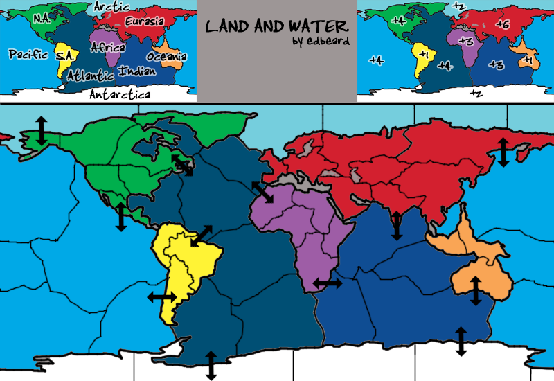
whitestazn88 wrote:i think its a step forward because it doesn't seem like there are so many attack points.

but at the same time, i still think they could be more accurately placed if you're gonna drop down to that few.
for example: the one in alaska is do-able because one can think that the bering strait is pretty shallow, land bridge, etc. same with the one in the new york harbor, and the mexico one is roughly placed where one could picture the rio grande.

but then what of the two africa ones? don't really make sense... move one to western europe instead of north africa in my opinion, and maybe move the one in se africa to the other coast? i think the tanzania or congo rivers flow out to that side.


I don't think we can take the "try to be real" perspective. We have to go with what works for gameplay. I do, however, think that the connection to western Europe works well. probably the se atlantic to africa as well. it would make Indian more of a +3 and add to making Atlantic a 'big' bonus area like it is (and like Inklosed pointed out).

I do appreciate your post, but I can't really use the perspective you're coming from.


Juan_Bottom wrote:Shouldn't S. America be worth +2? Each of it's territories is an attack point.

I think you should drop Antartica, shrink it down, and try and add some other territories. Who ever would attack Antartica in real world?


I had meant to make the attack route be to Colombia since it already serves as a border but I guess I put it in the wrong spot. 3 territories. 2 borders. +1. not a killer if someone gets it from the drop but who doesn't like an extra army?

Who would ever attack the South Indian Ocean in the real world? Who would ever attack Greenland in the real world. If you want to convince me (which you're not going to be able to on this by the way) your argument will need solid logic and reasoning. thanks for the post though!

p.s. from a gameplay perspective, it's good to have the land as a 'dead end' on the south whereas we have the arctic ocean as a 'dead end' up north. I'd rather have one area where everything spreads out (in a way) instead of three bonus areas stopping at one point with nothing there. also having it be four territories is good because we already have two continents of three territories

Re: Land And Water v2p4 gameplay talk

PostPosted: Sun Sep 07, 2008 6:17 pm
by MrBenn
edbeard wrote:right now I'm not worrying about graphics at all.

Has anybody mentioned that these graphics suck? Get a decent draft up if you want to be taken seriously... ;-)

On a slightly more serious note, have you put any thought into the 'golden' number of starting territories? I can't remember if 51 is considered golden or not?