Conquer Club

Indian Empire [Quenched]

Care to peruse completed maps? Take a stroll through the Atlas.

Moderator: Cartographers

Forum rules
Please read the Community Guidelines before posting.

Re: British India - I'm back! page 4

Postby MrBenn on Sat Nov 08, 2008 5:07 am

Balsiefen wrote:Nice one with the railways Oak.
Just a couple of quick things I picked up.

-You'll need to do some hand editing still on the railways where they join. At the moment they look a bit strange.
-I assume connecting cities via rail means holding every territory the railway goes through. That may need to be better worded as at the moment as I can see confusion with people who think they only need to hold the cities.


I recently discovered you can add a layer mask to a text layer, so you should be able to use that to to tidy up the joins without rasterising...
Image
PB: 2661 | He's blue... If he were green he would die | No mod would be stupid enough to do that
User avatar
Lieutenant MrBenn
 
Posts: 6880
Joined: Wed Nov 21, 2007 9:32 am
Location: Off Duty

Re: British India - I'm back! page 4

Postby oaktown on Sat Nov 08, 2008 11:51 am

MrBenn wrote:
Balsiefen wrote:Nice one with the railways Oak.
Just a couple of quick things I picked up.

-You'll need to do some hand editing still on the railways where they join. At the moment they look a bit strange.
-I assume connecting cities via rail means holding every territory the railway goes through. That may need to be better worded as at the moment as I can see confusion with people who think they only need to hold the cities.


I recently discovered you can add a layer mask to a text layer, so you should be able to use that to to tidy up the joins without rasterising...

I could do that, or I could smooth out the curves enough that they don't break. I fixed a lot of gaps before I posted this, but it was clear that there were more than I wanted to tackle at the moment.

And Balseifen is right with the wording - perhaps something simple like "hold all rail territories to connect two cities" - except I think we're moving away from the word "territory." Would "provinces" be appropriate on an old India map?
User avatar
Captain oaktown
 
Posts: 4451
Joined: Sun Dec 03, 2006 9:24 pm
Location: majorcommand

Re: British India - I'm back! page 4

Postby cairnswk on Sat Nov 08, 2008 6:23 pm

oaktown
if you're using PS3, there is railway line brush available at
http://www.adobe.com/cfusion/exchange/i ... id=1044414
Image
* Pearl Harbour * Waterloo * Forbidden City * Jamaica * Pot Mosbi
User avatar
Private cairnswk
 
Posts: 11510
Joined: Sat Feb 03, 2007 8:32 pm
Location: Australia

Re: British India - I'm back! page 4

Postby oaktown on Sun Nov 09, 2008 12:40 am

cairnswk wrote:if you're using PS3, there is railway line brush available...

Shit, yeah, that's a lot easier.

Click image to enlarge.
image

Made some stuff easier to follow, moved things around, added some images, and changed the territory layout around Calcutta - the old system made no sense.
User avatar
Captain oaktown
 
Posts: 4451
Joined: Sun Dec 03, 2006 9:24 pm
Location: majorcommand

Re: British India - page 5

Postby cairnswk on Sun Nov 09, 2008 1:06 am

oaktown, i imagine that link was a great help.
can i offer that the text in between tert names and region names is looking quite cluttered
since you already have the regions in the legend, is there any need for them to be on the map if you colour them in the legend.
This would surely remove a lot of clutter with names crossing one another in many instances.
Image
* Pearl Harbour * Waterloo * Forbidden City * Jamaica * Pot Mosbi
User avatar
Private cairnswk
 
Posts: 11510
Joined: Sat Feb 03, 2007 8:32 pm
Location: Australia

Re: British India - page 5

Postby oaktown on Sun Nov 09, 2008 1:47 am

cairnswk wrote:oaktown, i imagine that link was a great help.
can i offer that the text in between tert names and region names is looking quite cluttered
since you already have the regions in the legend, is there any need for them to be on the map if you colour them in the legend.
This would surely remove a lot of clutter with names crossing one another in many instances.

yep, there's a lot going on. I was thinking I'd either find some kind of alternative for the region names, or rework it using a mini-map in the bottom left corner. It's a work in progress.

Gameplay thoughts, anyone?
User avatar
Captain oaktown
 
Posts: 4451
Joined: Sun Dec 03, 2006 9:24 pm
Location: majorcommand

Re: British India - page 5

Postby cairnswk on Sun Nov 09, 2008 2:21 am

oaktown wrote:...
Gameplay thoughts, anyone?

Since the Andaman Islands are part of the Indian Union and featured in the British occupation of India, perhaps a sea route from either Calcutta or Madras to the Andamans? Would that be relevant?
Image
* Pearl Harbour * Waterloo * Forbidden City * Jamaica * Pot Mosbi
User avatar
Private cairnswk
 
Posts: 11510
Joined: Sat Feb 03, 2007 8:32 pm
Location: Australia

Re: Indian Subcontinent - version 4, pg 3

Postby MrBenn on Sun Nov 09, 2008 7:08 pm

MrBenn wrote:1. I just wanted to clarify the railway bonus - do you need just the start and end points, or do you need all the territories along the route?
2. The Calcutta-Delhi route increases the total for Bombay Presidency to +11 for 11 terrs... That has some sort of epic appeal ;-)
3. The Bay of Bengal and the rivers going through Bengal are very distracting... it took me a while to work out which area Bengal was... the position of the terr name helps a bit, but is still confusing...
4. The crease of the book feels a little bit too pink... is it possible to change the colour balance of the book layer to make it slightly browner?
5. the mountains could do with a little bit more variation - they look good, but I can see the recurring 'M' shape too easily
6. You mentioned the railway graphic - I've worked out why it looks out of place; there should be two tracks between the sleepers {=|=|=|=} instead of {-|-|-|-|-}
7. Have I mentioned that I like it? Keep up the good work ;-)

1. The legend could still be interpreted either way
3. This is a million times clearer now - issue resolved.
4. I still think the crease would be better being brownie-orange rather than pink... and the the glow around the region names should be paper-coloured (ie where the text goes over the crease, the glow should be the same colour...)
7. Can I say it again?

My biggest concern at the moment is #1 above, as it has a big impact ;-)
Image
PB: 2661 | He's blue... If he were green he would die | No mod would be stupid enough to do that
User avatar
Lieutenant MrBenn
 
Posts: 6880
Joined: Wed Nov 21, 2007 9:32 am
Location: Off Duty

Re: British India - page 5

Postby oaktown on Sun Nov 16, 2008 3:59 pm

Click image to enlarge.
image


Tweaks in this update...
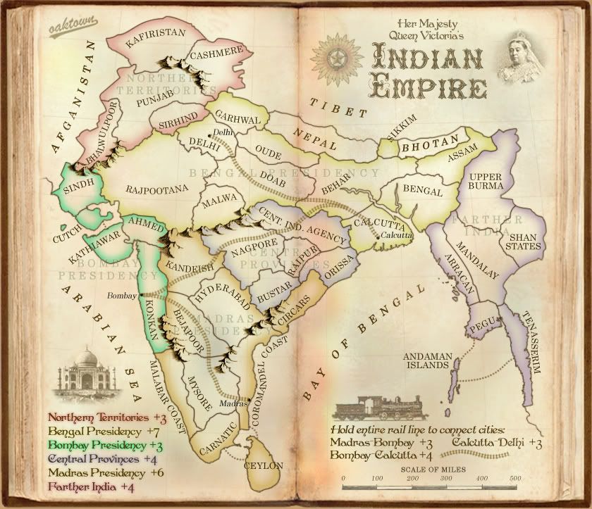
ā€¢ Region names in the legend now stroked the color of the region.
ā€¢ Region names on the map are now lighter, and they are the bottom layer. I still like them being there for colorblind help, and I hope that by hiding them a bit they don't interfere with other elements.
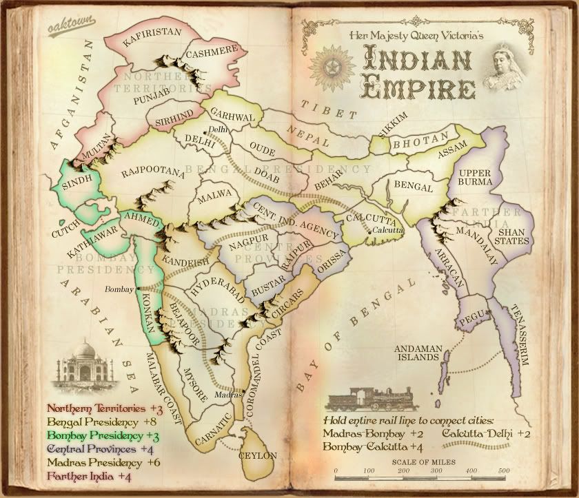
ā€¢ Played with some mountains to reduce the number of "M" mountains.
ā€¢ Rail description changed... any better?
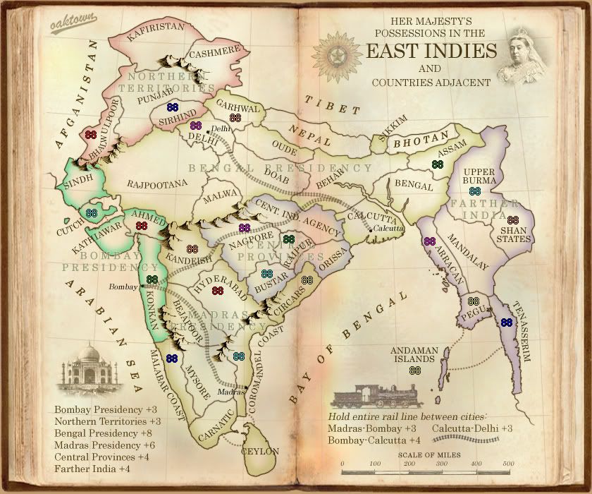
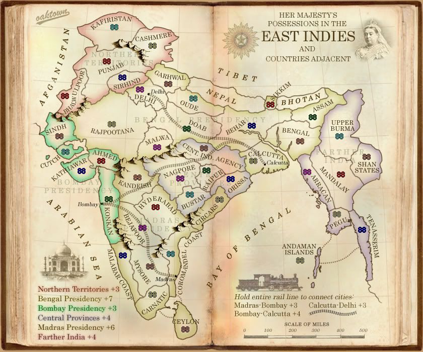
ā€¢ Made Bengal a +7, from +8... MrBenn pointed out that with the rail bonus its +11, which may be a bit too "epic."
ā€¢ All territories have army counts, just for purposes of getting everything in the right place... since there will be no army circles, I hope.

cairnswk wrote:Since the Andaman Islands are part of the Indian Union and featured in the British occupation of India, perhaps a sea route from either Calcutta or Madras to the Andamans? Would that be relevant?

Question: would a sea link from the Andaman Islands to either Calcutta or Madras (Coromandel Coast territory) be beneficial to play? It would make the Farther India region singificantly harder to hold, but add connectivity across the map. Going to Madras would certainly open the map up more, but add a border territory to the Madras region as well. Hmm?
User avatar
Captain oaktown
 
Posts: 4451
Joined: Sun Dec 03, 2006 9:24 pm
Location: majorcommand

Re: British India - map and question, page 5

Postby InkL0sed on Sun Nov 16, 2008 4:09 pm

No, to your question. Those continents have plenty of borders as it is.
User avatar
Lieutenant InkL0sed
 
Posts: 2370
Joined: Sat Jun 23, 2007 4:06 pm
Location: underwater

Re: British India - map and question, page 5

Postby Kaplowitz on Sun Nov 16, 2008 4:19 pm

Oak, you REALLY need to post a tutorial on how you made those mountains..... =P~

also: i can barely tell apart those 2 orange/yellow continents.
Image
User avatar
Private 1st Class Kaplowitz
 
Posts: 3088
Joined: Tue May 01, 2007 5:11 pm

Re: British India - map and question, page 5

Postby gimil on Mon Nov 17, 2008 9:25 am

In my humble opinion oaktown, Bengal and Madras are far to similarly coloured. It took a good close look for me to realise they were two different continents. On the map as well central and farthar india look very similar as well. I had a hard time differentiating these continents from their bonuses.
What do you know about map making, bitch?

natty_dread wrote:I was wrong


Top Score:2403
User avatar
Corporal 1st Class gimil
 
Posts: 8599
Joined: Sat Mar 03, 2007 12:42 pm
Location: United Kingdom (Scotland)

Re: British India - map and question, page 5

Postby iancanton on Sat Nov 22, 2008 5:48 am

just to let u know that i'll be stamping the gameplay on this map.

farther india looks distinctly magenta in the legend but violet on the map iteslf. unrelated to gameplay, below is a link to a map published by john bartholomew of edinburgh where farther india refers to what is today known as indochina plus the malay peninsula.

http://www.davidrumsey.com/maps5279.html

another one, showing farther india as upper and lower burmah plus indochina.

http://www.davidrumsey.com/luna/servlet ... r-India,-C

since farther india consistently includes indochina, i suggest burmah as the continent name.

for the title of the map, i like indian empire: british raj or something similar, so that it fits alphabetically in the gamefinder list. british east indies includes singapore, british malaya and british sumatra, which are not part of our subject matter.

ian. :)
User avatar
Colonel iancanton
Foundry Foreman
Foundry Foreman
 
Posts: 2424
Joined: Fri Jun 01, 2007 5:40 am
Location: europe

Re: British India - map and question, page 5

Postby captainwalrus on Sat Nov 22, 2008 8:09 pm

The graphics are the pretty similar to the Eastern Hemisphere map and the War of Tripple Alliance maps (not so much the second one). I like them but if all three get Quenched your going to have to make them pore different.
User avatar
Private 1st Class captainwalrus
 
Posts: 1018
Joined: Sun Nov 11, 2007 3:19 pm
Location: Finnmark

Re: British India - map and question, page 5

Postby captainwalrus on Sat Nov 22, 2008 8:13 pm

Also. The bonus fot the bombay-calcatta line shoucld be 3 not 4.
User avatar
Private 1st Class captainwalrus
 
Posts: 1018
Joined: Sun Nov 11, 2007 3:19 pm
Location: Finnmark

Re: British India - map and question, page 5

Postby oaktown on Sun Nov 23, 2008 2:11 pm

captainwalrus wrote:Also. The bonus fot the bombay-calcatta line shoucld be 3 not 4.

Really? Six territories, all of which are borders... if I was going to change it I'd say make it even higher, but I think it's in line with the others.

Thanks for stopping in, Ian... I'll get back on this map after (if) I've come up with a plan for the revamp competition.
User avatar
Captain oaktown
 
Posts: 4451
Joined: Sun Dec 03, 2006 9:24 pm
Location: majorcommand

Re: British India - map and question, page 5

Postby captainwalrus on Sun Nov 23, 2008 7:07 pm

My mistake, I was looking at the wrong rail.
User avatar
Private 1st Class captainwalrus
 
Posts: 1018
Joined: Sun Nov 11, 2007 3:19 pm
Location: Finnmark

Re: British India - map and question, page 5

Postby oaktown on Sat Dec 06, 2008 8:44 pm

Click image to enlarge.
image

Alright, so nobody likes the island connection idea. That was the most recent gameplay suggestion - anything else?

Changes to this version are mostly visual, though I did increase the overall size of the playing area so that the small map will work.

"Indian Empire" we will now call this map, so the map will be alphabetized under "I" as pointed out on the last page.

Mountains are very heavy looking all of a sudden... I'll see to that.
User avatar
Captain oaktown
 
Posts: 4451
Joined: Sun Dec 03, 2006 9:24 pm
Location: majorcommand

Re: Indian Empire (was British India) page 6

Postby The Neon Peon on Sat Dec 06, 2008 9:55 pm

Why did you include Bangladesh as part of India? I thought it broke away by that time... or I might need to revisit my history notes.
User avatar
Lieutenant The Neon Peon
 
Posts: 2342
Joined: Sat Jun 14, 2008 12:49 pm

Re: Indian Empire (was British India) page 6

Postby oaktown on Sat Dec 06, 2008 11:00 pm

The Neon Peon wrote:Why did you include Bangladesh as part of India? I thought it broke away by that time... or I might need to revisit my history notes.

I believe bangladesh was a part of british india right up until the brits split up the whole lot in 1947.
User avatar
Captain oaktown
 
Posts: 4451
Joined: Sun Dec 03, 2006 9:24 pm
Location: majorcommand

Re: Indian Empire (was British India) page 6

Postby The Neon Peon on Sun Dec 07, 2008 10:00 am

Just wondering... could you make a series of maps in this style? like the Japan and Brazil maps. Just old maps of the world in that book of yours.
User avatar
Lieutenant The Neon Peon
 
Posts: 2342
Joined: Sat Jun 14, 2008 12:49 pm

Re: Indian Empire (was British India) page 6

Postby oaktown on Sun Dec 07, 2008 11:28 am

The Neon Peon wrote:Just wondering... could you make a series of maps in this style? like the Japan and Brazil maps. Just old maps of the world in that book of yours.

I certainly could - and between my Brazil revamp entry, a short-lived attempt at Japan, and this, you could say I already have made a series! But in the end, it would be a bit boring both for me and for the site. I think it's a nice look, but I'm not sure it's that nice.
User avatar
Captain oaktown
 
Posts: 4451
Joined: Sun Dec 03, 2006 9:24 pm
Location: majorcommand

Re: Indian Empire (was British India) page 6

Postby InkL0sed on Mon Dec 08, 2008 11:42 pm

If you hold the Madras Presidency + the Madras to Bombay rail line, you get a +9. That seems excessive to me, considering you'd only have 4 borders.
User avatar
Lieutenant InkL0sed
 
Posts: 2370
Joined: Sat Jun 23, 2007 4:06 pm
Location: underwater

Re: Indian Empire (was British India) page 6

Postby oaktown on Tue Dec 09, 2008 12:09 am

InkL0sed wrote:If you hold the Madras Presidency + the Madras to Bombay rail line, you get a +9. That seems excessive to me, considering you'd only have 4 borders.

Yes, I'd agree... the trouble is which to knock down, the rail line or the region bonus? I think I'd lean toward the making the rail line a +2, because Presidency will be a bitch to hold if somebody else holds the Bombay Presidency and is dug in.

If we drop the Madras-Bombay line, it may be appropriate to also drop the Delhi-Calcutta line to +2, and possibly up the Bangal Pres bonus to +8 to preserve the big take for holding both.

Another solution would be opening up another border for Madras Presidency somewhere... I'll look into that.
User avatar
Captain oaktown
 
Posts: 4451
Joined: Sun Dec 03, 2006 9:24 pm
Location: majorcommand

Re: Indian Empire (was British India) page 6

Postby oaktown on Tue Dec 09, 2008 2:18 am

Click image to enlarge.
image


What's new: changed bonuses as noted above; added a mountain range in Farther India which makes that region a bit easier to hold with just two border territories; changed a territory name; added some decorative elements.
User avatar
Captain oaktown
 
Posts: 4451
Joined: Sun Dec 03, 2006 9:24 pm
Location: majorcommand

PreviousNext

Return to The Atlas

Who is online

Users browsing this forum: No registered users

cron