But the Japanese attacking Hawaii deal has more history. I think thats what N0g was referring to.
Conquer Club
Conquer Club, a free online multiplayer variation of a popular world domination board game.
https://www.conquerclub.com/forum/
World 2.0/1 Map [Quenched]
https://www.conquerclub.com/forum/viewtopic.php?f=358&t=6422
Page 3 of 43
oh, i was talking about history
You said where the islands of Hawaii cam from. But in this map (and the game in generally) countries don't spawn each other. Instead you attack from one to another. That's why I think Japan attacking Hawaii makes a bit of sense.
Well, i just thought historically it would be better, but that's ok.
Version 0.9
As always thanks for the comments and suggestions.
After taking a look at CCU which has a no continent center I'm persuaded that including Antarctica as a bridge amonst the continents is a good solution so I've added it in. I've made it four territories one for each of the four major territory claimants though France, New Zealand and Chile also claim territory and the British and Argentine territories overlap (as do Chile/Argentina). So not 100% accurate (not that the rest is either) but I think a reasonable approach.

I'm still thinking about Marvaddin's suggestion of the two tier bonus system. Conceptually I think it has merit and I agree with Scorba that if we go this route it would be interesting to have a few countries that are in multiple continents or regions (Turkey, European Russia maybe even Egypt as part of a Middle East region?). I think that if we implement the regions approach then I wouldn't look to add impassable borders (though I understand the desire for more bottlenecks.)
Current to do list looks like:
Split Asian Russia into 3 or 4 provinces.
Split Australia into 3 or 4 provinces (total).
Take an initial stab at creating sub-bonus regions:
1. Canada
2. United States
3. Australia
4. Russia
I think those are pretty straightforward. After that though thinks are murkier. Do we do something in Europe; maybe the original EU countries and/or Nordic states and/or ex-Warsaw pact/NATO countries? Africa needs the sub-bonus concept the most but how to split it? What does the forum think of:
http://en.wikipedia.org/wiki/Image:Africa-regions.png
Finally I think a Middle East sub-bonus region fits the map well but should we include Egypt or not?
Anyway I think those are the main issues. Probably won't be able to revise things until early next week as I've got a busy weekend. Thanks again for the input.
Cheers,
Zim
After taking a look at CCU which has a no continent center I'm persuaded that including Antarctica as a bridge amonst the continents is a good solution so I've added it in. I've made it four territories one for each of the four major territory claimants though France, New Zealand and Chile also claim territory and the British and Argentine territories overlap (as do Chile/Argentina). So not 100% accurate (not that the rest is either) but I think a reasonable approach.
I'm still thinking about Marvaddin's suggestion of the two tier bonus system. Conceptually I think it has merit and I agree with Scorba that if we go this route it would be interesting to have a few countries that are in multiple continents or regions (Turkey, European Russia maybe even Egypt as part of a Middle East region?). I think that if we implement the regions approach then I wouldn't look to add impassable borders (though I understand the desire for more bottlenecks.)
Current to do list looks like:
Split Asian Russia into 3 or 4 provinces.
Split Australia into 3 or 4 provinces (total).
Take an initial stab at creating sub-bonus regions:
1. Canada
2. United States
3. Australia
4. Russia
I think those are pretty straightforward. After that though thinks are murkier. Do we do something in Europe; maybe the original EU countries and/or Nordic states and/or ex-Warsaw pact/NATO countries? Africa needs the sub-bonus concept the most but how to split it? What does the forum think of:
http://en.wikipedia.org/wiki/Image:Africa-regions.png
Finally I think a Middle East sub-bonus region fits the map well but should we include Egypt or not?
Anyway I think those are the main issues. Probably won't be able to revise things until early next week as I've got a busy weekend. Thanks again for the input.
Cheers,
Zim
I think what you want to do is not get the map to look like the classic one. Splitting Australia in half and now your suggesting ur going to split asian russia is doing exactly that, making this map look more classic. Have you thought about my other suggestion, adding maldives as a link between Sri Lanka, Australia and Africa?
norwegian claim
you've misspelled norwegian. And if you want to know, the norwegian claim is actually called "Dronning Mauds Land" or in English "Queen Maud's Land". Nice little trivia for you there 
ooh, and since i'm on the scandinavian topic, you probably should have Denmark in there as well. The country is larger than a few others you put in there, and in population as well... just my 2 cents
Looks great so far, if more people want a third link, maybe the Galapagos islands (spelled ofcourse different) between Ecuador and Papua New Guinea.
I don't thing Denmark needs to be added, it is already to crowded in the North of Europe (that's why it was kicked in the first place)
Maybe an islamic subcontinent? Then you get Egypt in it.
Australia is fine!
I don't thing Denmark needs to be added, it is already to crowded in the North of Europe (that's why it was kicked in the first place)
Maybe an islamic subcontinent? Then you get Egypt in it.
Australia is fine!
Great to hear your considering the sub-bonus regions. My enthusiam for the map has increased a hundred fold.
With Europe, I'd recommend a three way split, with Scandinavia, Western (Italy, Germany and everything west) & Eastern (everything else).
Asia - from a strategic point of view it makes little difference whether Egypt is included in the Middle East, but it is a big political player in the region so it makes sense from that perspective. Other Asian regions could include The Orient (or South Eastern Asia) & the Indian Sub-Continent. With the Asian Russia split, it would be good to split it so that at least one territory is not a border.
North America - perhaps Central America including Cuba & the Carribean? It might be an idea to have Canada & the US combined into a single region. The US would be unholdable without first having Canada anyway, and Canada as a two country region would be too easy to take..
South America - I think Brazil needs to be split up and form another region. It currently dominates the continent, attacking nearly every other country and Africa as well. It can also hit NA in two moves. It's probably the most powerful country on the map as it stands, and certainly will be once Russia is further divided. If you decided to go down this route, I'm sure Marv could help with naming the territories.
Oceania - Perhaps include New Zealand and New Caledonia in with the Aus region? The other islands could form another region, though no idea what you'd call it.
Africa - I haven't got any ideas here. The Wikipedia page you posted looks like a good start though.
I also agree with the earlier poster that the straight dividing lines on Aus, Russia and Canada look ugly and somewhat out of place. Could you make them more like the US division?
Well, even in real life, Brazil dominates South America, so...  Joking, Im up to split it.
Errrr, lets talk about the map. This is one simple (and non artistical) suggestion about the minor continents:
Canada and USA in same continent would be strange, since they are very important and large countries. I would like each one in one own continent, but it seems difficult. So, maybe the place for an Asia of the real classic map
About Europe, I first thought about 3 divisions, but this one looks like better. I think we can remove Italy - Tunisia route. Also, the Eastern part has many borders, but Western would look strange without Austria. Maybe rename Austria to Hungary could be better. We also can think about change Russia to a whole Russia continent.
Africa: the main problem is the red region, a bit crowded. removing some countries there (like Cote Divoire, lol, Tunisia and Senegal) will correct the problem. Also, maybe we can remove Lybia - Sudan border.
Asia: by the way, Middle East will need remain as a little continent. What we can do is merge China and India continents, or China and Pakistan (even better), but I dont know if its a good idea. Maybe we can also split China. I think we can easily remove Malaysia, Taiwan and Nepal (unless we merge China and India). Before think again about Asia, we need see how will Russia be splitted. Hmmm, arent Indonesia and Philippines part of Asia in real life? Will these count really to Oceania in the map?
South America and Oceania are easier, we can do almost all. I believe South America fits well divided in 2, we can call one Amazon (or Amazonia) and the another one Mercosur.
Hey, can you please post a map without circles and bonuses next time? Its better for me to suggest something...
Dotless map...
Marvaddin,
Haven't had a chance to think through your suggestions but saw your request for a dotless map and since my illustrator file has them on a seperate layer it was an easy one to fulfill.

Cheers,
Mark
Haven't had a chance to think through your suggestions but saw your request for a dotless map and since my illustrator file has them on a seperate layer it was an easy one to fulfill.
Cheers,
Mark
My interest in this map is also increasing tenfold. The progress thus far is quite amazing, and I like the way it is heading. This could be a quite large and unique map, unlike many we have out there. I'll look for more about the two tier bonus system, along with the splitting of continents later. I'm glad you took my suggestion of a 'neutral' Antarctica. Looking good thus far, hopefully I'll be back later to comment.
--Andy
--Andy
I still think you need to adjust the colors of the countries so they are more uniform within the continents. but I guess that would need to change again if you add sub continents so you'll have to wait and see how to break that up.
sully800 wrote:I still think you need to adjust the colors of the countries so they are more uniform within the continents. but I guess that would need to change again if you add sub continents so you'll have to wait and see how to break that up.
Maybe the colors of the countries could be more uniform in the parts that are sub continents.. For example, if you were to separate US and canada, and mexico and guatemala(and the rest).. The US and canada could be one of the shades(maybe the darker blue) and then Mexico and guatemala(and the rest) could be another shade being used in north america, like the pinkish color.. That way they continents are more uniform, but you can differentiate between the subcontinents..
Yeah I agree. I'm thinking like different shades of each color for the subcontinent. So US+Canada could be dark purple and Central America+Carribean would be light purple, but that is all of the purple on the map. Then do that for each continent and sub continent. So NA is shades of purple, SA is brows, Africa reds, Europe greens, Asia blues and Australia yellows. The only problem you might run into is if a sub continent has countries from different main continents (Middle East would contain some Asia, Europe and Africa). I think that problem can be solved be simply keeping the subcontinents as pieces of the main continents. It may not be as fun for gameplay, but I don't know how else you would show whcih countries group together to form the various regions.
Pakistan+Afghanistan=Muslim India
Brazil+Uruguay=Portuguese South America or just Brazil
Not all of French Africa is French.
The East-West stuff in North America is annoying. New England. Colonial Canada. Frontier Canada. American Bayou. There's great names you are ignoring. And the midwest doesn't go that far west. And the straight lines are killing me. Can't you find a river somewhere?
But I like the map
happysadfun wrote:Pakistan+Afghanistan=Muslim India
Brazil+Uruguay=Portuguese South America or just Brazil
sorry but i don't agree, specially about uruguay
liking the map!
jsut combine pakistan and Afganistan into pakistan, they had a puppet gov. in afganistan for a while b4 9/11 anyway.
Sub territories....

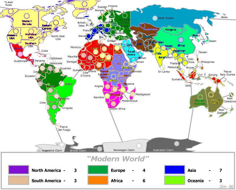
Please ignore the legend in the above I haven't updated the image to reflect my re-calculations of sub-bonus and continent values.
Happysadfun wrote:
The East-West stuff in North America is annoying. New England. Colonial Canada. Frontier Canada. American Bayou. There's great names you are ignoring. And the midwest doesn't go that far west. And the straight lines are killing me. Can't you find a river somewhere?
I agree the straight lines didn't look right. I've updated Canada and Australia using provincial/state boundries as a guide instead. Thanks for the nudge.
Sully800 wrote:
Yeah I agree. I'm thinking like different shades of each color for the subcontinent. So US+Canada could be dark purple and Central America+Carribean would be light purple, but that is all of the purple on the map. Then do that for each continent and sub continent. So NA is shades of purple, SA is brows, Africa reds, Europe greens, Asia blues and Australia yellows. The only problem you might run into is if a sub continent has countries from different main continents (Middle East would contain some Asia, Europe and Africa). I think that problem can be solved be simply keeping the subcontinents as pieces of the main continents. It may not be as fun for gameplay, but I don't know how else you would show whcih countries group together to form the various regions.
and Evil Pope wrote:
Maybe the colors of the countries could be more uniform in the parts that are sub continents.. For example, if you were to separate US and canada, and mexico and guatemala(and the rest).. The US and canada could be one of the shades(maybe the darker blue) and then Mexico and guatemala(and the rest) could be another shade being used in north america, like the pinkish color.. That way they continents are more uniform, but you can differentiate between the subcontinents..
I've attempted this in the version above using a uniform colour for the sub-continents but still using various colours (in the same family) for the rest of the continent. I think the colour difference's make the boundries clearer but they do also make it 'louder' so I can see both sides. Let me know what you think of the current version. I also agree the single territory in multiple sub-continents is strategically interesting (though it might turn out to be just a gimmick) but practically difficult and a source of confusion for those new to the map. The current implementation of sub-continents doesn't contain any "multiple" territories.
Marvaddin wrote (and drew):
Maybe the colors of the countries could be more uniform in the parts that are sub continents.. For example, if you were to separate US and canada, and mexico and guatemala(and the rest).. The US and canada could be one of the shades(maybe the darker blue) and then Mexico and guatemala(and the rest) could be another shade being used in north america, like the pinkish color.. That way they continents are more uniform, but you can differentiate between the subcontinents..
and Scorba wrote:
Great to hear your considering the sub-bonus regions. My enthusiam for the map has increased a hundred fold.
With Europe, I'd recommend a three way split, with Scandinavia, Western (Italy, Germany and everything west) & Eastern (everything else).
Asia - from a strategic point of view it makes little difference whether Egypt is included in the Middle East, but it is a big political player in the region so it makes sense from that perspective. Other Asian regions could include The Orient (or South Eastern Asia) & the Indian Sub-Continent. With the Asian Russia split, it would be good to split it so that at least one territory is not a border.
North America - perhaps Central America including Cuba & the Carribean? It might be an idea to have Canada & the US combined into a single region. The US would be unholdable without first having Canada anyway, and Canada as a two country region would be too easy to take..
South America - I think Brazil needs to be split up and form another region. It currently dominates the continent, attacking nearly every other country and Africa as well. It can also hit NA in two moves. It's probably the most powerful country on the map as it stands, and certainly will be once Russia is further divided. If you decided to go down this route, I'm sure Marv could help with naming the territories.
Oceania - Perhaps include New Zealand and New Caledonia in with the Aus region? The other islands could form another region, though no idea what you'd call it.
Africa - I haven't got any ideas here. The Wikipedia page you posted looks like a good start though.
I was going to attempt to implement a hybrid of your respective suggestions and actually began colouring the map accordingly. Anyway inspiration (or insanity) struck when I was doing the split of Russia and I thought why does every territory need to be part of a sub-continent. Could we not pick out selected parts of a continent and make them a bonus without having an equivalent bonus for every territory? This is the approach I've taken in the version above. I'm intrigued with it but I'm looking for feedback. My intial bonus/sub-bonus thinking would look something like:
North America(United States) 6(2)
South America(Amazon) 6(2)
Africa(Southern Africa) 12(7)
Europe(Western Europe) 8(3)
Asia(Middle East/Russia) 14(3/5)
Oceania(Australia) 5(3)
As with the previous bonus discussion these could be discounted preserving proportionality as best as possible if the consensus is they are two large.
GavinSidhu wrote:
I think what you want to do is not get the map to look like the classic one. Splitting Australia in half and now your suggesting ur going to split asian russia is doing exactly that, making this map look more classic. Have you thought about my other suggestion, adding maldives as a link between Sri Lanka, Australia and Africa?
I very much don't want to recreate classic. What do you think now that you can see Australia and Russia broken up and Antarctica added?
Thanks everyone for your suggestions and sorry if I missed anyone's input. Let me know what you think particularly on the "only selected countries are members of a bonus area" idea.
Cheers,
Mark
P.S. The circles are still a touch small at 15x15 so we probably need to lose a couple more in africa and maybe one or two of the smaller asian states (nepal?).
P.P.S. What do you all think of Oceania now that Australia is split? Should I consolidate Indonesia or leave it making Oceania a more 'average' size in terms of territories?
P.P.P.S. Noticed in reviewing this post that it isn't clear that northern Canada was intended to be part of the Eastern Canada territory. Looking at it seems we have two options; 1) recolour/move the dot/name, etc., so that it's membership as part of the East is clear. 2) promote it to it to be another territory "Nunanvut". What say you?
I say make it its own territory, Nunavut. And to make an even bigger subbonus- use "anglo-america": all of the us and canada, possibly making quebec separate and not including it. this would make three territories: quebec, maritimes, ontario. instead of an australia subbonus, what about an indonesia subbonus? madagascascar is in southern africa too. middle east also includes egypt, maybe make egypt an overlap country. differentiate sub-bonus colours more. i like the new version better. and i like the way this is turning out. (Originally I thought it would be a quick passing idea.)
do it as close as possible to real countries it looks like a challenge and i would be ahppy to play on it
If you are going to get rid of Nepal, split up China to create Tibet. Link New Zealand to New Caledonia. Isnt Sorong really Irian Jaya? The territory you call Northern Territory in Australia is actually comprised of South Australia and the Northern Territory and looking at the picture, the name Northern Territory doesnt really fit. Maybe you should split your 'Northern Territory' into the real Northern Territory and South Australia. Antartica should wrap around.
Borneo= Sulawesi and Borneo
Austria, Germany, Poland Not Western
Germany=Germany, Denmark (expanded)
SubBonus-Northern Muslim Countries=Kazakh, Stans, Iran, Afghanistan, Pakistan
Somalia=Overlap Arab Asia/Africa
Or you could use Greater Arab World in Africa and Asia as a giant subbonus including Mideast, North Muslim States, Algeria, Egypt, Somalia, Libya, Tunisia, Morocco, Mauritania, Sudan
I still think would be more interesting to have many sub continents in this map... however, we also can have some non continental areas, but I would not have this much.