Page 2 of 16

Re: Native America

PostPosted: Wed Mar 11, 2009 3:53 pm
by Bones2484
miniwally wrote:
Risky_Stud wrote:
miniwally wrote:i'll repeat what date did spanish go to america?


kind of a strange question for this thread.
And if you wanna know so bad, then google
it yourself.


it;s not cause you might want to include spanish in map


This is Native America. Why would she include the conquistadors?

Re: Native America

PostPosted: Wed Mar 11, 2009 4:56 pm
by miniwally
hmm good point

Re: Native America

PostPosted: Thu Mar 12, 2009 8:57 am
by Joodoo
Tisha wrote:The Victoria Island belongs to the Copper River tribe.. I was hoping to bring those together with the army numbers
The Southhampton island I'm not sure what to do with, it's not a territory oif it's own... I was thinking about just deleting the color off of it and leaving it neutral..

only two territories separate from their pack... I would like to put some canoe outline, or something ike that at the base of the Mississippi to connect Natchez and Choctaw


sounds good :D

Re: Native America

PostPosted: Thu Mar 12, 2009 4:20 pm
by Lobster Crush
Wow...looking very good. If I can think up a few names to replace the European ones on the map, I'll let you know.

One thing that you might want to do is lighten the borders, or the rivers. At the moment it's hard to distinguish the rivers as different from the borders.

Cheers,
LC

Re: Native America

PostPosted: Tue Mar 17, 2009 8:20 pm
by Risky_Stud
getting better, like the new names

Re: Native America

PostPosted: Wed Mar 18, 2009 12:27 am
by Herakilla
everything i can think of has been pretty much stated already. this map has jaw dropping graphics and just looks perfect already. my main issues are the borders cutting through the islands in the artic, some one them you can resolve with an army number i bet but some of them not so much.

also id like to add while the bonuses do need a little tweaking like people have said, the current set up makes the map rather realistic since there will be a lot more action in the south than in the north and thats how it was 500 years ago :) but seeing as this is CC id probably prefer a map that plays well and is decently accurate over a map that plays horribly and is perfectly accurate

Re: Native America

PostPosted: Sun Mar 22, 2009 11:15 am
by James Vazquez
Tisha wrote:The Victoria Island belongs to the Copper River tribe.. I was hoping to bring those together with the army numbers
The Southhampton island I'm not sure what to do with, it's not a territory oif it's own... I was thinking about just deleting the color off of it and leaving it neutral..

only two territories separate from their pack... I would like to put some canoe outline, or something ike that at the base of the Mississippi to connect Natchez and Choctaw


What an awesome idea... canoes for passable routes is genious!!! lends chaicter and authenticity all in one swoop..

I've had my heart on a map like this for as long as i have been here. The culture and politics were highly developed here long before europeans came and those aspects are rarely represented in everyday life. Most people dont know the extent the americas were populated prior to european colonazation.

Kudos Tisha!!!! =D> =D> =D> =D>

Re: Native America

PostPosted: Sun Mar 22, 2009 12:02 pm
by happy2seeyou
Wow Tisha you're doing another map. Looking forward to playing on it. :) Keep up the good work.

Re: Native America

PostPosted: Thu Apr 02, 2009 3:41 pm
by el-presidente
I see some problems, the fist is with the southwest. Say that someone has all the territories of the southeast bonus region on the east of the missisipi river, if he doesn't have some other territory on the other side then it is going to be really har for him to compleat his bonus. I like bonuses that are hard to get but then it needs to be worth more.

If the date is set at 1500, or give or take a bit, then you can have hispaniola and cuba both native territories that can border maya and seminole which would help solve the above problem and make the map easier to move around.

Is it just the font or is the H in hopi and hare not capitalized?


It looks great!


< el-presidente >

Re: Native America

PostPosted: Sat Apr 04, 2009 7:26 pm
by Dublanous1
WOW! For a first and second draft that is amazing, I would expect that to be maybe a 5th draft but it is beautiful, I have nothing to offer because alot of people have already took what I was originally going to say; but keep up the great work.
=D> =D> =D>

Re: Native America.. UPDATE page 3

PostPosted: Sun Apr 05, 2009 12:40 am
by Tisha
72 territories
11 bonus regions

-I'm still working on names of territories, and probably will be for quite a while.. any information there helps..
-added a canoe as a passable.... does it need to be put onto the map? or is it obvious?

Click image to enlarge.
image

Re: Native America.. UPDATE page 3

PostPosted: Tue Apr 07, 2009 6:56 pm
by sailorseal
Just three quick things because I love this map
1. Get rid of the compass it does not fit with the map
2. Either capitalize the names or don't but don't have it random
3. Add more canoes because that river really divides the map and only one looks odd

Re: Native America.. UPDATE page 3

PostPosted: Tue Apr 07, 2009 8:24 pm
by Ruben Cassar
Very nice map indeed Tisha. Well done!

However I must say that I have a big problem with the colours used. It is very hard for me to differentiate between a region and another.

Also would it be possible to have a mini map instead of just listing the various regions?

Re: Native America.. UPDATE page 3

PostPosted: Wed Apr 08, 2009 3:45 am
by Joodoo
is it possible to add a route between Aleut and Chugachigmiut?

Re: Native America.. UPDATE page 3

PostPosted: Wed Apr 08, 2009 6:42 am
by LED ZEPPELINER
beothuk and micmac need to connect also, love the mountains and boats

Re: Native America.. UPDATE page 3

PostPosted: Wed Apr 08, 2009 10:09 am
by Tisha
sailorseal wrote:Just three quick things because I love this map
1. Get rid of the compass it does not fit with the map
2. Either capitalize the names or don't but don't have it random
3. Add more canoes because that river really divides the map and only one looks odd


i like the compass.... why doesn't it fit?
all the names are capitalized, it's the font i'm using. (that i love)

Re: Native America.. UPDATE page 3

PostPosted: Wed Apr 08, 2009 10:13 am
by Joodoo
LED ZEPPELINER wrote:beothuk and micmac need to connect also, love the mountains and boats

I find it interesting that two territories belonging to the same continent are not adjacent, as it could slightly alter gameplay...
don't think there's need to connect those two territories

Re: Native America.. UPDATE page 3

PostPosted: Wed Apr 08, 2009 1:03 pm
by Tisha
Ruben Cassar wrote:Very nice map indeed Tisha. Well done!

However I must say that I have a big problem with the colours used. It is very hard for me to differentiate between a region and another.

Also would it be possible to have a mini map instead of just listing the various regions?


is it mostly the California Great Basin areas? like between Pomo and Paiute?

Re: Native America.. UPDATE page 3

PostPosted: Wed Apr 08, 2009 1:40 pm
by Ruben Cassar
Tisha wrote:
Ruben Cassar wrote:Very nice map indeed Tisha. Well done!

However I must say that I have a big problem with the colours used. It is very hard for me to differentiate between a region and another.

Also would it be possible to have a mini map instead of just listing the various regions?


is it mostly the California Great Basin areas? like between Pomo and Paiute?


Unless you did not know I am colour blind so I may be seeing the colours a bit differently. What could help is making the adjacent regions' colours different from each other to help differentiate between them.

I have a problem with more than one region actually. Aren't Pomo and Paiute part of the same region?

Re: Native America.. UPDATE page 3

PostPosted: Wed Apr 08, 2009 1:55 pm
by ustus
two other things that bug me:
first, the map looks very very red on my screen, i think it would be easier to read if the saturation of the generally red aura the whole map has was turned down a bit.
Second, the Arctic region looks like it has two terits that aren't connected to the rest of the region: Aluet and Chugachigmiur. I think that no region should have to go through another region to attack a terit that is part of its bonus. Makes it really hard to take that bonus.

though, both of these are deff my personal opinion, so let me know what you think.

Re: Native America.. UPDATE page 3

PostPosted: Wed Apr 08, 2009 3:10 pm
by thenobodies80
Good map! An interesting project.
Mountains are beautiful.
And the possibilities of developing a great map are very high! :)

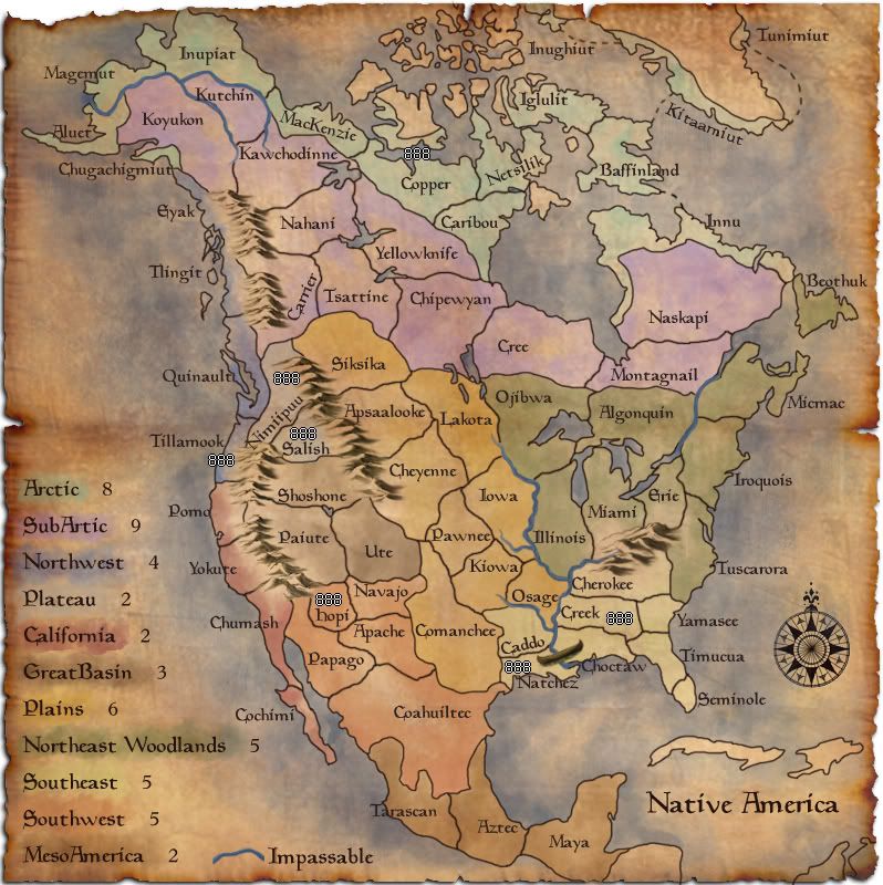
I think you have to work a lot on colors, i'm not colorblind but there're some zones that are very difficult to distinguish. :?
For exemple Meso America color is "invisible" in the legend.
Plateau is difficult to find on map.
You have to make more clear some regions....
Where is Eyak and where is tlingit?
What regions Beothuk can attack?
I suggest you to "remove" the northern zone of copper region, make only confusion

Personally i think the legend is very big

You need to balance the game, a good start in the south could be an easy +2 bonus (for meso america) withonly 1 border to defend (coahuiltee)
Rivers make the east zone impenetrable, Mountains do the same in the west part, and there's a big vertical central zone in which seems more difficult to find a quick way to take the dominance during the game.

Any suggestions for bonuses now...

Anyway, your map is one of the best i've seen in the last period.
C'mon! Make really great this map
=D>

TNBDS

Re: Native America.. UPDATE page 3

PostPosted: Wed Apr 08, 2009 3:24 pm
by Lobster Crush
Tisha wrote:
sailorseal wrote:Just three quick things because I love this map
1. Get rid of the compass it does not fit with the map
2. Either capitalize the names or don't but don't have it random
3. Add more canoes because that river really divides the map and only one looks odd


i like the compass.... why doesn't it fit?
all the names are capitalized, it's the font i'm using. (that i love)


That's actually a good point about the compass...I'm pretty sure it was a European invention, and that there wouldn't have been a compass (at least in that style) in pre-European N.A.

However, there definitely was an understanding of the cardinal points of the compass in Native North American culture, with the points of the compass figuring prominently in culture & mythology. Perhaps incorporating a less European-looking compass would work?

Cheers,
LC

Re: Native America.. UPDATE page 3

PostPosted: Wed Apr 08, 2009 3:38 pm
by Bones2484
Tisha wrote:
sailorseal wrote:2. Either capitalize the names or don't but don't have it random

all the names are capitalized, it's the font i'm using. (that i love)


I think sailor is referring to "Hopi". The uppercase "H" just looks like a lower case one, but if you take a look at real lower case "h"s on the map, you can see they are different.

Re: Native America.. UPDATE page 3

PostPosted: Wed Apr 08, 2009 4:11 pm
by Bones2484
Ruben Cassar wrote:
I have a problem with more than one region actually. Aren't Pomo and Paiute part of the same region?


Actually no, those are different regions. I can see the problem though as the background on the mountain range kind of fades down into the California territories. The same mountain background color matches the Paiute region perfectly.

Re: Native America.. UPDATE page 3

PostPosted: Wed Apr 08, 2009 4:21 pm
by ben79
Ruben Cassar wrote:Very nice map indeed Tisha. Well done!

However I must say that I have a big problem with the colours used. It is very hard for me to differentiate between a region and another.

Also would it be possible to have a mini map instead of just listing the various regions?


i have to agrre for the colours ( i'm colorblind ) and it's really hard to make a difference between the regions ! a mini-map would help !