Page 1 of 2
The Seven Seas [Vacation]

Posted:
Thu Apr 20, 2006 11:52 pmby supermarcol
This is a first draft for an Ocean map. The colors and graphics are not final, so please don't tell me they need to be improved

. The map obviously wraps around and you can attack through the Panama canal and Bering straight. Please feel free to comment/give suggestions, especially if you know more about the names of these places.
[See further for more recent map]
P.S. Maybe someday we could paste this map on the world map...
Posted:
Fri Apr 21, 2006 12:05 amby Hoff
sounds like a good idea. I dont like how the territories are really pointy and whatnot tho. maybe you can rounden them up. Also and idea would be to do somethign with the gulf stream and any other currents that are in the ocean. You could use them as natural borders or territories themselves. or maybe a one way attack route where you can attack several territories beyond 1. ex. if you control where the gulf stream starts, lets just say the caribean. you will be able to send your troops flying down the stream and be able to attack the west coast of europe. Just an idea but i think it could be cool.
Posted:
Fri Apr 21, 2006 1:06 amby casper
nice idea. 1) shouldn't the arctic seas all touch if they're one territory? maybe connect beauforts and barents north of greenland. 2) you mention the bering strait and panama canal. what about arabian sea to aegean sea via suez canal? 3) i'm also not sure about the 5 point connection in the indian ocean. it just doesn't look natural... although maybe it would be cool.
Posted:
Fri Apr 21, 2006 1:11 amby thegrimsleeper
Wow, what a creative idea.
You should have all the uncontinents be seperate shades of blue/blue-green/black... You could have the borders be a light grey and white as the territory names.
Give us the Panama Canal, and the "West Coast of ______" should be changed to "East Atlantic/North America," like you did for the Indian.
Using the streams as borders is probably unneccesary, with the continents already providing isolation enough, but using them as one-way attack routes would be interesting, if you could make it graphically feasible.
You should also download a copy of Photshop. There's quite a few people on here that will help get you up-to-speed with the program, if you've no idea what you're doing.

Posted:
Fri Apr 21, 2006 2:21 amby Axelius
casper wrote:nice idea. 1) shouldn't the arctic seas all touch if they're one territory? maybe connect beauforts and barents north of greenland.
I guess that "lands" are connected at the ends, that is Kara Sea-Chukchi Sea, South China Sea and Philippine Sea-Timor Sea, Crozet Basin and Enderby Sea-Ross Sea.
But it's only a guess...
Posted:
Fri Apr 21, 2006 8:06 amby fishfleas
I like the general idea. Artistically I would say make the ocean borders a bit less angular. Make them more organic in nature. You need to make a more dratic color for land so it doesn't blend in so much. The color should be dark, whatever color you pick. Hope that helps.

Posted:
Fri Apr 21, 2006 8:23 amby zorba_ca
This is an awesome idea!!! Love it.
As for the map:
1. I agree with all the previous posts...the territories are too angular (try to avoid territories joining at points) and the land should be a darker colour.
2. In keeping with the traditional Seven Seas, the Pacific should be divided into 2 continents: North and South Pacific, and the Mediterranean Continent should be a territory of the North Atlantic.
3. Include the "land masses" of the Arctic & Antarctica
4. Make it clear that the edge territories of the Arctic and Antarctic wrap around so they can attack each other.
Looking forward to seeing a more developed version, but definitely lots of promise here.
Posted:
Fri Apr 21, 2006 8:56 amby supermarcol
About the pointyness comment: yes I know that it looks very pointy, but it is only a first draft. I do not intend to let it look like that. My idea is to make the map look like a treasure map with pirates and stuff.
The wrapping around and various canals will be made clear later on, but at the stage where the graphics are right now, I thought it was a waste of time.
I know about the traditionnal seven seas and I might change it to that, I don't know yet. Right know I guess its "supermarcol's the seven seas".
I already have photoshop and will probably use it to get the map right, but right now I'm using my good 'ol flash
.
About the currents, I don't know how I could do that, but I'll keep that idea in mind.
I haven't figured out the bonuses yet and the borders are not final, so keep sending in your suggestions. It looks like this idea pleases most people, which is what I was looking for.
You'll hear more of me in the coming days
Posted:
Fri Apr 21, 2006 9:02 amby Jota
Wow. This does to my brain what the Crossword map does to some other people's. (Not that this is a bad thing).
Posted:
Fri Apr 21, 2006 12:03 pmby rocksolid
Great Map!
Some name suggestions:
East Coast of N.A. -> Sargasso Sea or Gulf Stream
Labrador Sea -> Davis Strait
Philippine Sea -> Coral Sea (I think the Philippines are actually in your South China sea)
Straight of Gibraltar -> Strait of Gibraltar or Pillars of Hercules
Aleutian Sea -> Hawaiian Sea, if you stretch it a little farther southeast. Right now the Aleuts are definitely beyond its borders, up in the Bering Sea; you might also call this Kuro Shio
West Coast of S.A. -> Chilean Sea or Galapagos Sea
South Pacific Sea -> Magellan Sea (not a great name but he spent a lot of time there)
Central Pacific Basin -> Polynesia, or Polynesian Sea
East Pacific Basin -> Pitcairn Sea, or Rapa Nui, or Fletcher Christian Sea, or something like that. There's no good name for this one.
West Coast of Europe -> Canary Current
Norwegian Sea -> North Sea
Tropic of Capricorn is a good name, but it's also in the Pacific, so you could change this one to St. Helena.
Timor Sea - > there's so many seas in this territory and they're all pretty small - Bay of Bengal, Andaman Sea, Gulf of Thailand, Java Sea...the actual sea of Timor is in what you now have labelled as the Philippine Sea - so it's hard to choose one that's right. I think you'd be better off naming this territory after the straits that have historically been the focus of all navigation in the East Indian, the Straits of Malacca.
Madagascar Sea is a good name, but if you don't like it, you can change it to Mascarene Sea.
Argentine Sea - Falklands Sea or Malvinas Sea or Mar Malvina.
I like the idea of making the Red Sea a separate sea, and connecting it with the Aegean through Suez.
I also think you could have fun by throwing the Bermuda triangle in there somewhere, and giving it one-way-in-attack - you can attack it but it can't attack anything.
Posted:
Fri Apr 21, 2006 12:38 pmby Fieryo
if you want another "country" for red, you could add the black sea which would be attached to the Aegean on the map.
Posted:
Fri Apr 21, 2006 12:50 pmby thegrimsleeper
Posted:
Fri Apr 21, 2006 12:53 pmby hockeycapn
as has been said in a previous post, Suez Canal should be a connection.
Posted:
Fri Apr 21, 2006 1:03 pmby Marvaddin
Well, there are some good ideas here... and the new names will be good, too. Very creative, I admit. Im interested.
A little idea for now: dont use that 5 corners border in the green area. It makes the routes confused.
Another one: change the map name... 7 isnt the correct number

It seems a joke but its serious.
Very Cool Idea!!
Posted:
Fri Apr 21, 2006 1:09 pmby Scarus
I like this. It's great to see so much original thought going on in the foundry. Don't know if it's possible, or even desirable, but I also think using the bermuda triangle in some unique way would really give your map some distinction.
Great Start!!
Posted:
Fri Apr 21, 2006 1:19 pmby zorba_ca
Great idea with the Bermuda Triangle!
Maybe you could fortify your armies in and they mysteriously appear in any one of your other territories! (it's a joke...)
I'm just waiting for the day when one player clicks "Advance All". We should set up a special forum now.
Let us know when you have the next version out SuperMarc.
Posted:
Fri Apr 21, 2006 1:19 pmby supermarcol
I like the Bermuda triangle idea too! so I'm adding the bermuda triangle, the red sea and the black sea. Now I'm at 45 countries, I'd like either 42 or 48, so if you have ideas for adding 3 countries or taking out 3 it would be great. I don't want to add anything to the north atlantic, cause its pretty big already. Also I was thinking, I don't know if its doable, but it would be great if the bermuda triangle can attack one random country, it could change each turn or be the same for the game or something. It would make every game unique

. And yes, the shape of the borders will change greatly, it won't be pointy and I'll make sure its clear, I'm still at the stage to figure out the countries, I'll add th art later.
[EDIT]Oh yeah! I'll make it so you can't see how many armies are on the bermuda triangle bwahahahah
Posted:
Fri Apr 21, 2006 1:24 pmby zorba_ca
Take out one territory in the Mediterranean and make the remaining two territories part of the North Atlantic.
Split the Pacific up into North and South Pacific.
That gives you 42 with 7 "continents"
If you want, add 3 more to the North and South Pacific to make them worth more.
Posted:
Fri Apr 21, 2006 1:31 pmby Jota
The Bermuda Triangle idea is a cool one, but if you do it, there should be some clear mention of it on the map. It doesn't have to be explicit about what happens, but a cryptic "Beware the Bermuda Triangle!" or "Strange things happen in the Bermuda Triangle" in the map's legend would be a very good thing.
Posted:
Fri Apr 21, 2006 1:35 pmby rocksolid
If you're looking to add three more...
Break off the west corner of the Chukchi sea and call it the Laptev sea.
Carve out the north part of the Ross sea and call it the Great Australian Bight.
Norwegian (or North) Sea can be broken up into many sub-seas - The Irish Sea and the Baltic - but they'd be pretty small. Or you could carve out a Hawaiian sea from what is now the Central Pacific Basin.
Posted:
Fri Apr 21, 2006 1:59 pmby supermarcol
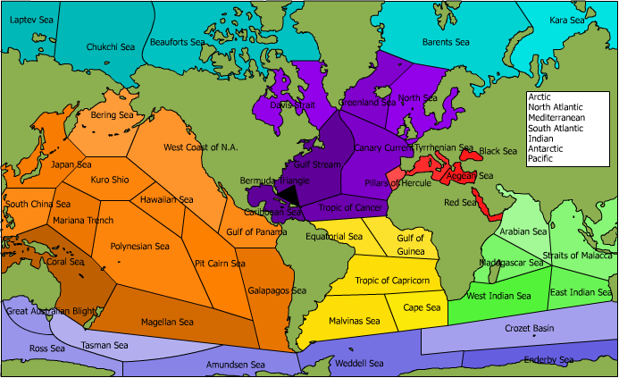
This is what I think will be the country distribution of the map. Thanks a lot rocksolid, your geographical knowledge is incredible! The map is a bit confusing right now; I'll work on the graphics soon, but for now I have to go. Keep shooting suggestions!
(you might have to hit refresh to see the latest version)
Posted:
Fri Apr 21, 2006 2:04 pmby Jota
How do the Arctic seas border each other around the pole?
Posted:
Fri Apr 21, 2006 2:11 pmby rocksolid
That's great, Marcol!
A few typos - Great Australian Bight, not Blight; Hercules, not Hercule; Beaufort, not Beauforts (it sounds plural when you say it because of the S in sea); Pitcairn, not Pit Cairn.
I'm glad to see Antarctica popping up. And the Bermuda triangle - the possibilities are endless! Maybe your armies should disappear and pop up in someone else's game on the website somewhere, like say in the Middle East halfway through somebody's turn. (JK)
Posted:
Fri Apr 21, 2006 3:27 pmby zorba_ca
I renew my opinion to merge the Mediterranean with the Atlantic (except for the Red Sea, which would join the Indian) and to split the Pacific into 2 "continents".
Right now it is 13 territories. Really...is anyone ever going to be able to hold that?
Posted:
Fri Apr 21, 2006 3:37 pmby Chiater
Ha, well the pacific was supposed to be sorta like asia.. I was saying it was pretty big but he said he wanted it to be almost impossible to get.. The pacific IS pretty damn big in real life. but yeah, maybe it should be split up and whatnot. The map needs to be thought through and considered on a strategic AND esthetic level