Page 1 of 1
Boston MBTA

Posted:
Mon Jan 25, 2010 6:18 pmby Cloudyssky
Okay I was thinking of doing something with the Boston MBTA train system (Called the "T" locally)
I think there's plenty of stops for enough sections.
Here's a map of the system :
http://images.fanpop.com/images/image_u ... 4_1022.gifHere's my thought:
Additional troops would be based off of the 'lines' on the train system.
There's the Green Line, Red Line, Orange Line, and Blue Line. Possibly we could add the ferry terminal as a territory too.
So. Thoughts?
Re: Boston MBTA
Posted:
Mon Jan 25, 2010 7:04 pmby Industrial Helix
Copyright might be an issue...
Also, don't really care for subway maps

Boston might be cool though!
Re: Boston MBTA
Posted:
Mon Jan 25, 2010 7:31 pmby Cloudyssky
Good point.
Boston would be fun.
How about something during the Boston Tea Party?
Re: Boston MBTA
Posted:
Mon Jan 25, 2010 7:59 pmby Industrial Helix
Cloudyssky wrote:Good point.
Boston would be fun.
How about something during the Boston Tea Party?
A Historical City Map? You have my support!
I dunno if it has to be anything tea party related... but Revolutionary time period would be pretty cool. Check out this map which also includes Lexington and Concord.
- Click image to enlarge.
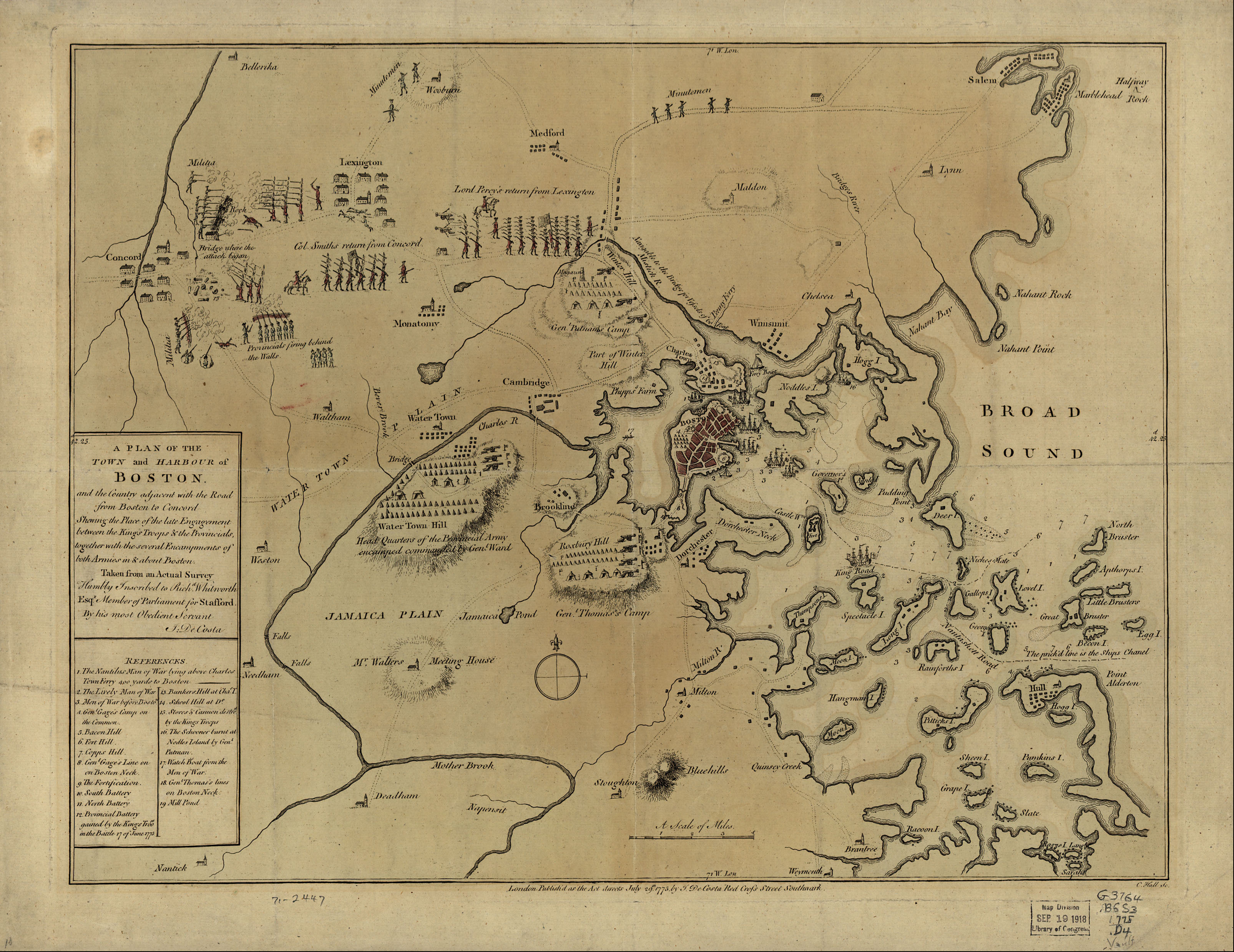
All the islands and hills to occupy ect. could be real fun.
Re: Boston MBTA
Posted:
Mon Jan 25, 2010 8:10 pmby Cloudyssky
Amazing! So let's get some more people on board. I'll start up something in paint.
Re: Boston MBTA
Posted:
Mon Jan 25, 2010 8:14 pmby AndyDufresne
Cloudyssky wrote:I'll start up something in paint.
Never something good to hear!

But I've always like the idea of a transit map, if one can work around the copyrights---or even of an old city map.
--Andy
Re: Boston MBTA
Posted:
Tue Jan 26, 2010 4:34 amby natty dread
Cloudyssky wrote:Amazing! So let's get some more people on board. I'll start up something in paint.net
sounds better

Re: Boston MBTA
Posted:
Tue Jan 26, 2010 1:27 pmby carlpgoodrich
I love the idea of a Boston map. I think I would rather something more similar to Vancouver than a Revolutionary War map. Boston/Revolutionary War is a huge cliché, and I think Boston has so much current culture and distinct regions that it would make for a really good map. There could still be references to the colonial days, but lets keep it current.
An idea for how the bonus regions might look (not the territories!):

-carlpgoodrich
Re: Boston MBTA
Posted:
Tue Jan 26, 2010 3:19 pmby Industrial Helix
carlpgoodrich wrote:I love the idea of a Boston map. I think I would rather something more similar to Vancouver than a Revolutionary War map. Boston/Revolutionary War is a huge cliché, and I think Boston has so much current culture and distinct regions that it would make for a really good map. There could still be references to the colonial days, but lets keep it current.
An idea for how the bonus regions might look (not the territories!):
-carlpgoodrich
Yeah, but I'm so sick of maps with metros. Plus, city maps tend to be all the same lately, they've got those little water ways that allow three playrs to each take a section of the city and scwabble the rest of the game. We need something different when it comes to city maps.
Re: Boston MBTA
Posted:
Tue Jan 26, 2010 4:43 pmby Cloudyssky
Industrial Helix wrote:carlpgoodrich wrote:I love the idea of a Boston map. I think I would rather something more similar to Vancouver than a Revolutionary War map. Boston/Revolutionary War is a huge cliché, and I think Boston has so much current culture and distinct regions that it would make for a really good map. There could still be references to the colonial days, but lets keep it current.
An idea for how the bonus regions might look (not the territories!):
-carlpgoodrich
Yeah, but I'm so sick of maps with metros. Plus, city maps tend to be all the same lately, they've got those little water ways that allow three playrs to each take a section of the city and scwabble the rest of the game. We need something different when it comes to city maps.
Agreed. I'm still working on something with paint. Should have it done by tonight. I'd like to do something historical with Boston with a mixture of the urban landscape.
Re: Boston MBTA
Posted:
Tue Jan 26, 2010 5:27 pmby Cloudyssky
This is just a rough draft of territories.
As for those purple white boxes? I was thinking there could be a bonus chain with "British Offices" if we do this pre-revolutionary war. If not we can simply remove them. But this is something along the lines I'd like to see.
- Click image to enlarge.

URL:
http://s807.photobucket.com/albums/yy35 ... ston-1.jpg
Re: Boston MBTA
Posted:
Tue Jan 26, 2010 5:33 pmby Industrial Helix
Wow... that wasn't too bad. You said Paint and the foundry cringed lol.
I like the general break down, those docks look like they have a lot of possibility tied to them as well.
I like the "British Offices" idea, perhaps you could use British Garrisons?
Re: Boston MBTA
Posted:
Tue Jan 26, 2010 5:37 pmby Cloudyssky
Industrial Helix wrote:Wow... that wasn't too bad. You said Paint and the foundry cringed lol.
I like the general break down, those docks look like they have a lot of possibility tied to them as well.
I like the "British Offices" idea, perhaps you could use British Garrisons?
Heh thanks I'm a noob at this crap, but we all have to start somewhere.
Garrisons wouldn't be too bad of an idea. I know when Boston was put in shut down by the British at one point around the time of the Boston Massacre (another good map idea right there!), British Ships blocked all entrance to Boston so perhaps I could add some little sailor boats as well.
Re: Boston MBTA
Posted:
Tue Jan 26, 2010 5:40 pmby Industrial Helix
Blockade Bonus perhaps?
You should check out Paint.net, I think Natty uses it and he seems to do alright with the tools given there.
One other thing concerns me about this map, the base image is likely copyrighted... maybe not as I look at it it cites 1880 as the date. You might be able to just steal this map and make some alterations. That's be good cause I really like the old map.
Re: Boston MBTA
Posted:
Tue Jan 26, 2010 6:16 pmby Cloudyssky
- Click image to enlarge.

Added three British ships, Public Garden, and The Dock.
Again as a reminded this is a very simple rough draft. Just giving a basic idea.
Re: Boston MBTA
Posted:
Wed Jan 27, 2010 1:46 pmby natty dread
You should check out Paint.net, I think Natty uses it and he seems to do alright with the tools given there.
I have to say, paint.net works great, and there's nothing that can't be done with it that can be done with bigger & more expensive software. Sometimes you need to go through more trouble, as it is a relatively simple software, though.
However the most important thing about working with paint.net is getting the right plugins. I think I posted somewhere in the foundry tips forum a list of the most essential plugins, in a mapmaking perspective.
After that you just need to be creative.
Re: Boston MBTA
Posted:
Wed Jan 27, 2010 8:00 pmby Cloudyssky
I'm using Paint.net now. Thanks.
Another tips for the map?
Let's keep ideas rolling!
Re: Boston MBTA
Posted:
Wed Jan 27, 2010 9:16 pmby carlpgoodrich
If we want to make a Revolutionary War map, then I think you are on the right track. However, if that's the case I don't think we should sell it as a "Boston" map, even if it takes place in Boston. Boston in the revolutionary war times was very different than it is now (for example, much of Boston today is land fill that did not exist then). Plus, as someone who grew up in Boston, making a revolutionary war map of Boston simply will not capture the city's spirit. Landmarks like Fenway, the Swan Boats, Boston Latin School (country's oldest public HS), Faneuil Hall, and Copley Square, just to name a few, are critical elements of Boston that cannot be ignored in a "Boston" map but did not exist in the revolutionary war times. I think it is possible to include historical elements of Boston while still keeping it in the present.
Re: Boston MBTA
Posted:
Wed Jan 27, 2010 9:21 pmby Cloudyssky
carlpgoodrich wrote:If we want to make a Revolutionary War map, then I think you are on the right track. However, if that's the case I don't think we should sell it as a "Boston" map, even if it takes place in Boston. Boston in the revolutionary war times was very different than it is now (for example, much of Boston today is land fill that did not exist then). Plus, as someone who grew up in Boston, making a revolutionary war map of Boston simply will not capture the city's spirit. Landmarks like Fenway, the Swan Boats, Boston Latin School (country's oldest public HS), Faneuil Hall, and Copley Square, just to name a few, are critical elements of Boston that cannot be ignored in a "Boston" map but did not exist in the revolutionary war times. I think it is possible to include historical elements of Boston while still keeping it in the present.
Agreed. Perhaps I can add such historical places that are modern but existed back in those days. I live South of Boston pretty much and I go there when I can, and the city just has such history. So perhaps places like Bunker Hill, The Boston Public Library, etc. could be added since they did exist back then and still capture the spirit of Bahstan
Re: Boston MBTA
Posted:
Wed Jan 27, 2010 10:09 pmby Industrial Helix
I'd say draw up a modern Boston map and lets see what you guys have in mind then.
I'm not entirely opposed to a modern Boston map, it's just I'm kind of tired of the usual "choke points at the waterways and a metro across the map" approach to city maps. Surely there has got to be a better way.
One idea that I liked from a while back was Paul Revere's ride... perhaps this could be tied in with the Revolutionary Era and you could do a Boston region map instead. That is, if you decide to continue with the Revolutionary map idea.
Re: Boston MBTA
Posted:
Wed Jan 27, 2010 10:41 pmby Cloudyssky
Industrial Helix wrote:I'd say draw up a modern Boston map and lets see what you guys have in mind then.
I'm not entirely opposed to a modern Boston map, it's just I'm kind of tired of the usual "choke points at the waterways and a metro across the map" approach to city maps. Surely there has got to be a better way.
One idea that I liked from a while back was Paul Revere's ride... perhaps this could be tied in with the Revolutionary Era and you could do a Boston region map instead. That is, if you decide to continue with the Revolutionary map idea.
I love the Revolutionary idea, I'd rather pass on modern, and you've made great points as to why I should. Perhaps as for territories there could be the names of famous Bostonians during the Revolutionary days? Ex: Paul Revere's House, Thomas Jefferson's House, etc.
Re: Boston MBTA
Posted:
Sat Jan 30, 2010 2:53 pmby MrBenn
This could be interesting...
For information, when posting images from Photobucket, you need to post a "direct link" to the image rather than a link to the photobucket viewer; there's also no need to put [img] tags within [bigimg] tags - I've edited the earlier post for you so you can see what I mean