Page 1 of 3
The Baltic States (Updated Feb 2, Vote!) [Vacation]

Posted:
Thu Jan 18, 2007 4:39 pmby happysadfun
1
I have a feeling people won't like it... it's supposed to make for relatively quick games....
25 territories
3 continents
Posted:
Thu Jan 18, 2007 6:00 pmby happysadfun
Hello?
Posted:
Thu Jan 18, 2007 6:11 pmby AndyDufresne
No one's home.

--Andy
Posted:
Thu Jan 18, 2007 6:18 pmby johloh
-photos at the top are bad
-the textures on the bottom cont. and the middle cont. are pretty ugly.
-im not sure that having only 3 continents will actually lead to 'quicker' games. it seems to me that it would be very hard to get a continent and get bonuses to give you an advantage. therefore people will be dealing with the 3 bonus armies for many turns and that will slow the game down.
Posted:
Thu Jan 18, 2007 6:19 pmby Marvaddin
Quench it!!!
Hehe, your feelings were correct...
How could it be designed for shorter games with continents that have at least 4 borders? And the continents are like 1/3 of the map. Would them really be holdable in games with 5-6 players? In fact, I think 32 should be the minimum amount of countries in any map.
Ooooh, and its too ugly, too.
However I feel some potential. Make the image bigger (the playable area, I mean), add more countries, at least 5 more, and create at least 2 more continents... It can become a map.

Posted:
Thu Jan 18, 2007 8:59 pmby happysadfun
Ok, I'm working on a new one. I have a topographic map and countries with transparent fill.... good idea?
Posted:
Thu Jan 18, 2007 9:01 pmby Heimdall
I don't like the Baltics one. Sorry
Posted:
Thu Jan 18, 2007 9:07 pmby happysadfun
Yeah, but that one sucked. Come back later for the new one.
Posted:
Thu Jan 18, 2007 11:26 pmby btownmeggy
Get rid of the current textures and make them more subtle. Remove pictures. Add the rest of Europe to wherever it should be, even if it's just a black, correctly-shaped mass. LABEL the three countries/continents.
Other stuff, too.
DON'T GIVE UP! Ask for graphics help if you need it, or illegally download programs if the task requires it. I support you in your efforts.
Posted:
Fri Jan 19, 2007 4:37 pmby happysadfun
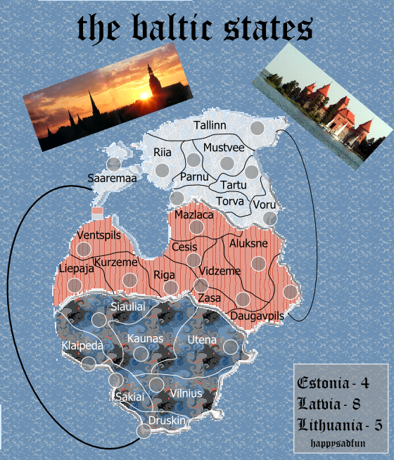
2
Better?

Proposed Bonuses:
Inland Estonia- 5
Outer Estonia- 5
Latvia Nord- 4 (I'll add a bridge or two)
Riga et la Latvia Sud- 6
Upper Lithuania- 5
Lower Lithuania- 4
Kalinigrad- 1
Posted:
Fri Jan 19, 2007 5:12 pmby Wisse
to tiny
Posted:
Fri Jan 19, 2007 5:13 pmby Lone.prophet
put kalingrad in the orange
Posted:
Fri Jan 19, 2007 5:15 pmby AndyDufresne
I think the idea of Baltic States could be interesting...but why not 'zoom' in even more, and make a larger country map. Right now, the amount of countries feels too small...
--Andy
Posted:
Fri Jan 19, 2007 5:33 pmby Ruben Cassar
Lone.prophet wrote:put kalingrad in the orange
Kaliningrad is not part of the Baltic States. It's a part of Russia. I wouldn't include it at all.
Posted:
Fri Jan 19, 2007 5:34 pmby happysadfun
Lone.prophet wrote:put kalingrad in the orange
I don't think so, because then Lower Lithuania would be yellow, and the yellow is very similar to the green
Andy wrote:I think the idea of Baltic States could be interesting...but why not 'zoom' in even more, and make a larger country map. Right now, the amount of countries feels too small...
Where do you suppose I should make more countries? I've got to basically start over, but that's OK because this wasn't hard.
Posted:
Fri Jan 19, 2007 5:35 pmby AndyDufresne
All areas.
I'd really just like to see a more zoomed in and focused map of the area...as long as you can include all the Baltic States. Splitting up some of the countries into others, and making a larger map of the area could be interesting.
--Andy
Posted:
Fri Jan 19, 2007 5:45 pmby happysadfun
Does anyone know how to make an image bigger in Inkscape? I have GIMP too but it didn't work well for the kind of map I was aiming this to be....
Posted:
Fri Jan 19, 2007 6:03 pmby happysadfun
2.01
Posted:
Fri Jan 19, 2007 6:21 pmby Marvaddin
You can even make it a bit smaller, to add legend, etc. But your other images was really tiny, so its making difficult to add more territories to the map. And I agree about not using any russian area.
How about if you try with 5 continents, friend?
Posted:
Fri Jan 19, 2007 6:37 pmby happysadfun
2.11
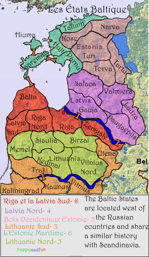
Added legend... that's about it.
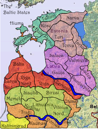
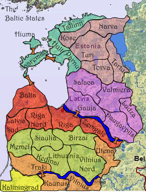
It's got 30 territories, where do you reccomend I split them?
Posted:
Fri Jan 19, 2007 6:47 pmby Ruben Cassar
Remove Kaliningrad...it's not part of the Baltic states...and why are you using French!?

Posted:
Fri Jan 19, 2007 6:51 pmby Guiscard
Looks promising. Needs a fair few more countries though. 36-40 would be great. I think both Lithuania and Latvia could do with more territories.
Posted:
Fri Jan 19, 2007 6:58 pmby Ruben Cassar
Guiscard wrote:Looks promising. Needs a fair few more countries though. 36-40 would be great. I think both Lithuania and Latvia could do with more territories.
And this map could help you in this task:
http://en.wikipedia.org/wiki/Image:Baltic_states.png
Posted:
Fri Jan 19, 2007 6:59 pmby Guiscard
*high fives Cassar* Double Team!
Posted:
Fri Jan 19, 2007 7:13 pmby Gilligan
Instead of having the bonus names in the back, color code the legend.
It needs more territories too.