If its too hard, dont worry, I can work around it.Telvannia wrote:i will keep trying though seeing if i can find what is wrong with it
Conquer Club
Conquer Club, a free online multiplayer variation of a popular world domination board game.
https://www.conquerclub.com/forum/
Indian Subcontinent
Page 3 of 4
Just adding it to this pagegavin_sidhu wrote:
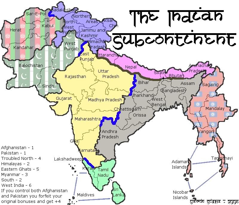
btw, can aksai chin attack northern areas, and can northern areas attack badakhshah? and there's an imaginary territory above bengladesh and between w bengal and assam
That imaginary territory is part of West Bengal, the one way arrow sorta split it. Will fix.
Edit coming soon. Working on getting rid of the jaggedness is in the country borders, expanding the size of the small countries and getting better uncrossables (nobody cares about accuracy of uncrossables do they?)
Edit coming soon. Working on getting rid of the jaggedness is in the country borders, expanding the size of the small countries and getting better uncrossables (nobody cares about accuracy of uncrossables do they?)
yeah. it would work better if you showed all of the ganges or whatever that river is, and put in bridges.
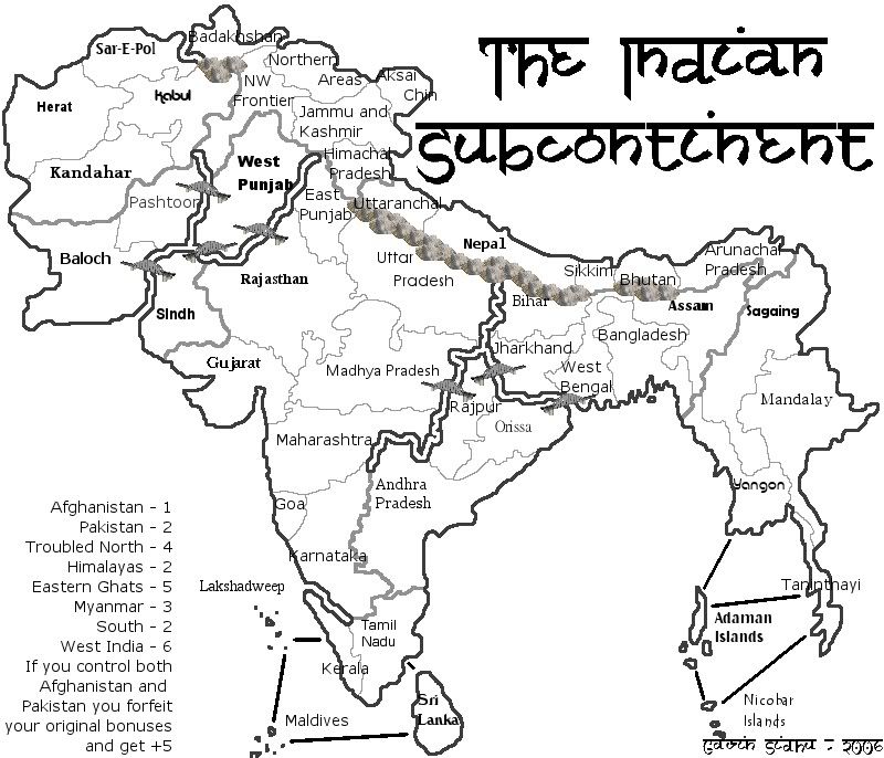
Pick a font. Used happysadfun's mountains, thanks.
wow, what a response... Lucky this wasnt the only forum i posted it in.
Other people have said that Andhra Pradesh, Sri Lanka, Maharashtra, Kabul, Madhya Pradesh, Uttar Pradesh as well as the original which is all over the map.
Other people have said that Andhra Pradesh, Sri Lanka, Maharashtra, Kabul, Madhya Pradesh, Uttar Pradesh as well as the original which is all over the map.
Sri Lanka's font is best.
Orissa
Really, this map is not attractive to many people, by the way...
About the font, I would go with Lakshadweep or Madhya.
About the font, I would go with Lakshadweep or Madhya.
ok.. gavin I've learned something... Gimp blows for making text... I suggest you do everything that I did on my france map. .and while you are trying to beautify it.. you switch to a trial of photoshop.. It comes with image ready which functions as photoshop quite well actually... and use that to pretty it up.
Then do a nice drop shadow.
Then do a nice drop shadow.
by attractive do you mean appealing? Attractiveness i can fix, appeal is a little harder to change.Marvaddin wrote:Really, this map is not attractive to many people, by the way...
About the font, I would go with Lakshadweep or Madhya.
Ive sorta figured this map lacks appeal (don't really know why, they're all killing each other in real life.) Should i just quit? I think i might work on this map silently and post update when i think its closer to being finished, if ppl like it, it gets quenched, if ppl dont I'll print out a copy and play when friends come ova.
I find this map appealing.
What do you think about exending the Afghanistan & Pakistan concept by splitting The Troubled North in half?
ie. 1 army each for either Indian Controlled North (J&K, HP and AC) or Pakistan Controlled North; 5 for holding both.
Or you could offer a 5 bonus for holding any 2 of the 4 continents with 1 bonus.
In the troubled north i have (even though its not written there) a rule which allows any country in the region to attack any other country in the region eg. Badakshan could attack Himachal Pradesh. Also if i split the north up like that it wouldn't be too geographically correct, Badakhshan is part of Afghanistan and AC although claimed by india, is occupied by China. I think your idea about the 5 bonuses for holding 2 subcontinents is good but i dont think it will work with this map because the area is not in the centre of the map, but off to one side.mightyal wrote:I find this map appealing.
What do you think about exending the Afghanistan & Pakistan concept by splitting The Troubled North in half?
ie. 1 army each for either Indian Controlled North (J&K, HP and AC) or Pakistan Controlled North; 5 for holding both.
Or you could offer a 5 bonus for holding any 2 of the 4 continents with 1 bonus.
I realise that my names for the sub-continents are poor; they were just the first ones that came into my head that made my subdivision obvious. The reasoning behind the idea was that it matches the reality on the ground. The whole area's a warzone seething with troops.
But, I do see your point about playability. With cc's random troop placement, it would be too likely to give someone a huge advantage.
I'd forgotten about all countries in The Troubled North being able to attack each other. That's a great idea; you should have a symbol (suicide bomber IMO) on each country to emphasize that and state on the legend what the symbol means.
mightyal wrote:I'd forgotten about all countries in The Troubled North being able to attack each other. That's a great idea; you should have a symbol (suicide bomber IMO) on each country to emphasize that and state on the legend what the symbol means.
Was thinking about using something like this in the key, but its too small and im pretty sure its copy-writed.


I find appeal to this map.. attractiveness. no. The first one was best but it seems to get worse each update..
I agree that the original version looked best. The rivers are really ugly at the moment. Tamriel has nice rivers (the water texture is good too). I think the shadows really help, as does the narrowing as the rivers near their source.
nah his latest update has good rivers.. very north america esque.. although I maintain that for aesthetic things you get photoshop.. alot more options.. drawing borders gimp is a must.
you could take away some of burma. because not all of it's subcontinental, and since it's a region map and not a country map, you don't have to be totally accurate. it would even work if you just made it a view, like this view:
http://www.meteotest.ch/img/am/gh_indiansubcont.png
http://www.meteotest.ch/img/am/gh_indiansubcont.png
I think ill keep burma as is.
To Happysadfun: Could u plz edit ur picture out, it being so large makes it so annoying to read any other posts.
U sure reverend_kyle, i tried using photoshop (albeit only for 5 minutes without reading the instructions) nd found it had pretty much the same things as GIMP.
To Happysadfun: Could u plz edit ur picture out, it being so large makes it so annoying to read any other posts.
U sure reverend_kyle, i tried using photoshop (albeit only for 5 minutes without reading the instructions) nd found it had pretty much the same things as GIMP.
gavin_sidhu wrote:I think ill keep burma as is.
To Happysadfun: Could u plz edit ur picture out, it being so large makes it so annoying to read any other posts.
U sure reverend_kyle, i tried using photoshop (albeit only for 5 minutes without reading the instructions) nd found it had pretty much the same things as GIMP.
have you tried layer effects? maybe its because I know photoshop like the back of my hand but drop shadow bevel and emboss all much improved on photoshop.
Inkscape has good transparency and good layers. That's all that's good about it. My computer can't install GIMP, eventho it's w2000. So I'm currently using inkscape. it sucks.
gavin_sidhu wrote:
Pick a font. Used happysadfun's mountains, thanks.
It needs colour.