Page 1 of 10
Middle America Map {Advanced Draft} ~ NEW UPDATE 2.3!!

Posted:
Thu Jul 27, 2006 4:25 pmby maritovw
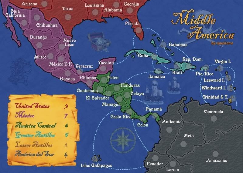
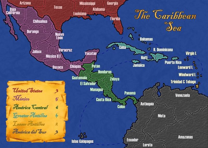
MIDDLE AMERICA MAPVotes have been cast. People have decided. As of today, this map has been renamed from CARIBBEAN SEA to MIDDLE AMERICA.
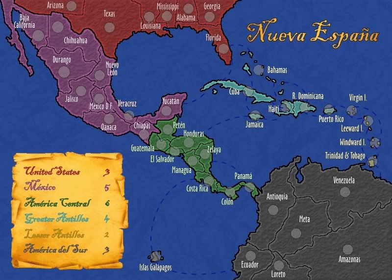
Current version (2.3):---Large map---
- Click image to enlarge.
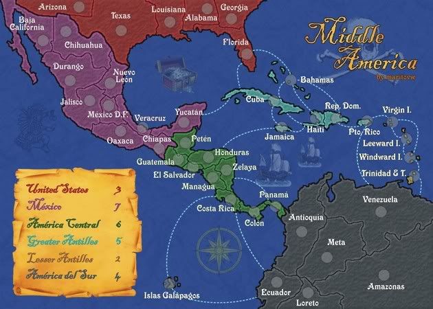
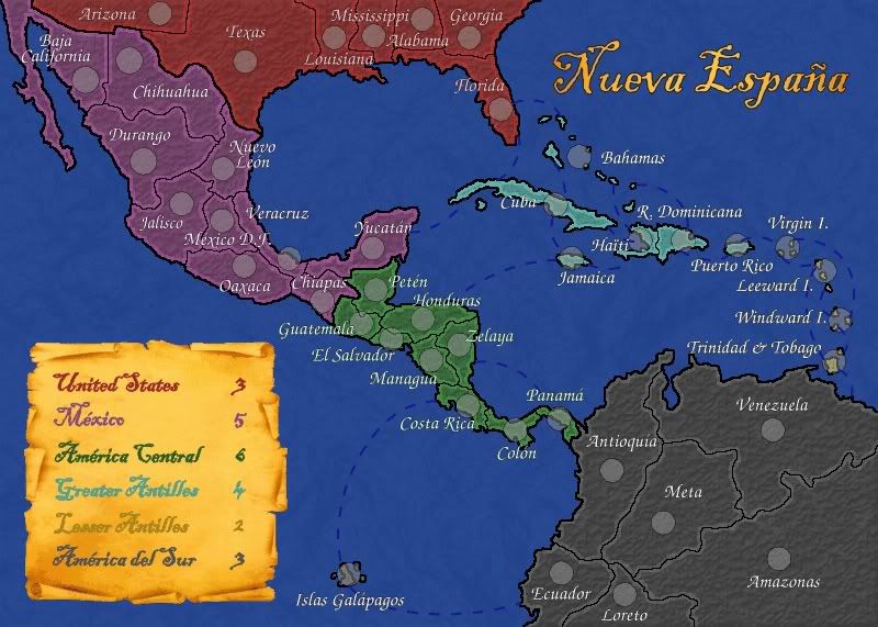
---Small map---
- Click image to enlarge.
The map is already in an advanced development stage, having a nice image and balanced gameplay. I need your comments and/or suggestions on this map so that I can make any changes needed (if any) and advance this map through the foundry. If you don't have any suggestions but you think it is a nice map and would like to play it, say it too!
The map was started a while ago but development stalled as I was 'away' from CC for a long time. Recently I returned and I've taken up development on the map, willing to finally finish it.
Latest Changes (Version 2.3)- removed connection between T&T and Leeward I.
- rearrange names in greater antilles
- change the hue of territory names in the USA
- changed the title to Middle America
GameplayThis map depicts the Middle America region, which includes southern USA, Mexico, Central America, Antilles, and northern South America. The gameplay follows that of a standard map.
The map has 42 territories distributed in 6 continents, which are:
- United States (3)
- México (7)
- América Central (6)
- Greater Antilles (5)
- Lesser Antilles (2)
- América del Sur (4)
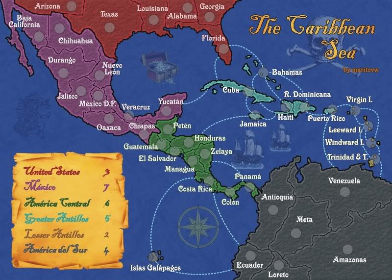
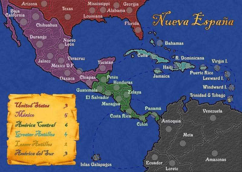
Previous Versions
Posted:
Thu Jul 27, 2006 4:57 pmby Marvaddin
1st, about the green borders, you can merge some really, because you will probably still add 1 or 2 more borders conecting to the isles, so...
2nd, about circles, I usually make them a bit smaller in the small map, but you can use the same size, no problem. To have idea about the size, get some number like 18 and 20 from some game map, because you cant test without the xml.
3rd and most important, I dont think you have the better font... Some letters are not ok... like the "o". Its good, for a title, for example, but not for the names in the map. And, the names are crowded, like I said. See El Salvador and Guatemala, and Managua... terrible! But not worse than the small isles... Puerto Rico and Virgin Islands, huh?? You will probably need merge the smaller countries and add space to the east of the small islands. maybe you can use better some space... South America has huge countries you can split if needed.
Posted:
Thu Jul 27, 2006 5:48 pmby rocksolid
Lookin' good. I'd shift the whole colour palette up and make things lighter, because it's real dark. I love the font but can't read it a lot of the time. And it's not clear which islands can/can't attack each other. Like can you attack the Leewards from Puerto Rico? And does Cuba border Yucatán?
Posted:
Thu Jul 27, 2006 5:50 pmby Master Bush
Why make this as a Pirates of the Caribbean theamed map?
Bad idea maybe.
Posted:
Thu Jul 27, 2006 6:01 pmby wcaclimbing
i like it keep it how it is (just finish it up)
Posted:
Thu Jul 27, 2006 6:17 pmby motts444
the font is sort of hard to read
Posted:
Thu Jul 27, 2006 7:27 pmby reverend_kyle
motts444 wrote:the font is sort of hard to read
if your illiterate.
Posted:
Thu Jul 27, 2006 7:31 pmby sully800
I agree that the pallette is a bit too dark for my liking and the font is not very good for the country names. It does work for the title but the countries should be simpler and easier to read.
I think that the bonus for Central America is too high also. 6 men for 10 countries and 4 borders (which can be simplified to 3 by expanding into mexico). Whereas Mexico has 10 countries and 5 borders (can be simplified to 4) but only a bonus of 5? I would just reverse them...make Mexico 6 and Central America 5 and it seems more even.
I like the naming of America del sur. I certainly don't think they all have to be in English. I would just color code the continent names when you add the legend to avoid any confusion for people who are looking for "South America" and can't find it.
Good map overall so far!
Posted:
Thu Jul 27, 2006 9:27 pmby maritovw
what do you think about the fonts? are they better now?
now that the sea connections are there, maybe the bonuses are quite right, don't you think??
now i'll just be adding the circles and some images (i was thinking of a compass, a couple pirate-like ships, and some sharks)
one more thing, i'm thinking of adding a connection between Zelaya and Panama so that you don't need to pass also Costa Rica and Colon in order to get to South America...
Posted:
Fri Jul 28, 2006 3:04 amby Ronaldinho
the maps looking great i can read the font and im semi blind almost

lol
ME straing to see ->

Posted:
Fri Jul 28, 2006 6:20 amby gavin_sidhu
looks good.
One suggestion, could u rename peten belize (ive heard of belize, but i havent of peten).
Posted:
Fri Jul 28, 2006 11:53 amby Ronaldinho
gavin_sidhu wrote:looks good.
One suggestion, could u rename peten belize (ive heard of belize, but i havent of peten).
Re-name it what?
Posted:
Fri Jul 28, 2006 12:26 pmby maritovw
gavin_sidhu wrote:One suggestion, could u rename peten belize (ive heard of belize, but i havent of peten).
that's because Belize is a country, Peten isn't... peten is a part of Guatemala that occupies most of the land it has in my map... Belize is a small part of that territory (and it used to be part of guatemala too but the british fooled us and took it away)... so i think i should leave as it is...
[just FYI] maybe you have heard of the Mayan ruins of Tikal?? well, that's in Peten

Posted:
Fri Jul 28, 2006 2:53 pmby colinb007
I think it's almost perfect!!!
I just cant keep track of the smaller islands though
Posted:
Fri Jul 28, 2006 3:04 pmby reverend_kyle
maritovw wrote:gavin_sidhu wrote:One suggestion, could u rename peten belize (ive heard of belize, but i havent of peten).
that's because Belize is a country, Peten isn't... peten is a part of Guatemala that occupies most of the land it has in my map... Belize is a small part of that territory (and it used to be part of guatemala too but the british fooled us and took it away)... so i think i should leave as it is...
[just FYI] maybe you have heard of the Mayan ruins of Tikal?? well, that's in Peten
I think you should merge peten and guatemala.. make it 2 borders there.
Posted:
Fri Jul 28, 2006 7:29 pmby Ronaldinho
colinb007 wrote:I think it's almost perfect!!!
I just cant keep track of the smaller islands though
yeah but part from that PERFECT!
Posted:
Fri Jul 28, 2006 7:34 pmby reverend_kyle
just refreshed the picture and the font is too much.. I liked the old font much more... the impact font hurts my eyes.
Posted:
Fri Jul 28, 2006 7:39 pmby Ronaldinho
try comic sans thats a wicked sick font!
Posted:
Fri Jul 28, 2006 7:50 pmby reverend_kyle
i liked the font before.. ti complimented the style.
Posted:
Fri Jul 28, 2006 7:52 pmby Ronaldinho
just try comic sans and see, its a real good font honest
Posted:
Sat Jul 29, 2006 12:39 pmby rocksolid
reverend_kyle wrote:I think you should merge peten and guatemala.. make it 2 borders there.
Boo. I dissent. Keep them separate.
Posted:
Sat Jul 29, 2006 1:16 pmby happysadfun
what about the us? i really don't get its connection to the caribbean, and arizona and texas really don't need to be there. i love the map, but there are these little parts that make it less of a caribbean map and more of a middle america map. florida is worth keeping though.
Posted:
Sat Jul 29, 2006 1:30 pmby AndyDufresne
During the last attempt at are Caribbean map, I was wondering a few of the same things regarding the importance of some countries. For instance as noted,
Arizona - Far from the Caribbean.
Baja California - Same
The West side of Mexico
The West side of Central America
Parts of South America, far from the Caribean
One idea is that you could combine countries, Peten and Guatamala, Honduras and El Salvador, etc. Making it so there aren't countries that are just on the pacific...considering a pacific only touching country would make much sense on a Caribbean map, at least my logic.
The problem though is, if this is done, harder to get the number of countries needed. Essentially you get rid of a 1/3 or so of the countries, which makes it perhaps difficult to find replacement areas.
Maybe the best idea, is look into creating a 'closer look' of the Caribbean. Where you only see the East side of Mexico, Florida, perhaps a few of the other gulf states, and even less of South America.
Just some thoughts and ideas.
--Andy
Posted:
Sat Jul 29, 2006 2:46 pmby maritovw
when i started making this map, i first tought about the region of where i wanted to do the map, then i tought about the name... so i don't like the idea of merging and removing much territories... maybe i should change the name, "middle america" maybe like happysadfun said... any suggestions for the name???
about the font, i liked the last one too but it was kinda hard to read, i think this one is better, and i'm not much of a comic sans fan, but i may give it a try....
Posted:
Sat Jul 29, 2006 3:06 pmby sully800
I think its fine calling it a Carribean map. That is the central part of this map, with some surrounding areas as well. I suppose I'm just not picky about the title but I don't think its worth sacrificing countries and gameplay just so the title is more accurate.
I still don't like the new font....its much easier to read but too tall and blocky- doesn't seem to fit with the map well anymore. I just looked through some fonts quickly and I think something like Book Antiqua, Courant or Papyrus would look better for the map but still be more legible than the first font was.
I like the overall look of the map a lot right now. However the islands seem unclear- you can't really tell which names belong to which islans, and which ones are grouped together. Perhaps you could distinguish the different areas better somehow? I don't know exactly what to suggest....perhaps an outline around the groups of islands or a different coloring in the water? I think those would both look gaudy but right now its too hard to tell what the labels are talking about.
You also seem to be missing some connections in the islands. I'm assumign Jamaica attaches to Haiti or Cuba or both but its not marked. Puerto Rico is probably supposed to connect to R Dominicana and Virgin I. And the Lesser Antilles seem to be missing a few connections as well or else I am just not understanding the labels.