Page 1 of 3

New York City Map

PostPosted: Wed Mar 22, 2006 10:42 am
by seamusmacdeath
Ok guys,
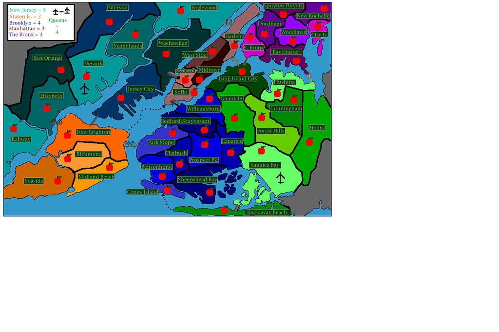
this is an extremely ROUGH DRAFT, which means the graphics are not really up to snuff yet. right now, i'm primarily concerned with how the map plays with its allotments of territories, certain border crossings, and bonus situation. please keep the graphics comments to a minimum as those will be addressed before any final version is submitted. however, some graphic-related things to note:

1. the labels on each territory are meant to look like nyc street signs.
2. the apples are where the troop count will show up (they can be removed if we're not too big on them)
3. the shitty little airplane icons mean that these two territories cann attack each other. i thought this would be an interesting addition to the game, considering that long distance attacks haven't been done yet. (once again, the icons will be improved with the next version)
4. the bridges and tunnel are an attempt at accuracy for my part.

if you have any game-play related ideas, corrections, etc. please feel free to let me know.

-mike
(SmacD)


Image

PostPosted: Wed Mar 22, 2006 10:48 am
by HighBorn
looks ok for a start i think
newjersy should be 6

queens 5
and
brooklyn 5

PostPosted: Wed Mar 22, 2006 11:11 am
by moz976
I think this map looks pretty good. Mostly just needs to be cleaned up to look nicer. I do like the idea of being able to attack nonadjacent properties.
I think the amounts are about right for the bonuses.

PostPosted: Wed Mar 22, 2006 12:50 pm
by hotgun
All I will say is... it needs a lot of help

PostPosted: Wed Mar 22, 2006 2:36 pm
by thegrimsleeper
hotgun wins the award for Most Helpful Post of All Freakin' Time.

:roll:

I think you've already nailed it. The perspective you chose is perfect, the airplane idea is fantastic... Bravo.

Lose the apples, make the bridges larger.

I'd say one of the routes into Manhatten should get taken out, or at least be a one-way route OUT of Manhatten... This one should be really cool once you do a for-real version.

PostPosted: Wed Mar 22, 2006 6:03 pm
by superman
not very good, I would not include jersey at all, It's not part of NYC
and
the map looks very crowded

PostPosted: Wed Mar 22, 2006 6:13 pm
by supermarcol
I think you should keep it, It doesnt have to be just new york, like europe map includes a bit of asia and africa. I think you'll have to review the bonuses totally. Broklyn needs waaaay more than that. Also there are a huge amount of attack routes for everything. Maybe you should take some out. As for a frist draft its pretty good, but it is way to crowded. Its hard to figure out whats going on. Take the apples out for now, change the names to something more subtle, and maybe make the boarders thinner. This will help for the discussions cause I have a headache from looking at it :) . It looks like you did that in paint. If its the case, try to get a graphic program like photoshop, that would make it easier to work on, and give better result. Other than that it looks like there are plenty of obstacles which would make a great map. Keep working on it!

PostPosted: Wed Mar 22, 2006 8:50 pm
by casper
this looks like a good start.

definitely keep new jersey as part of it. after all don't all the "new york" sports teams play in jersey? ;)

seeing as manhattan is the most valuable part of nyc it might make sense to "warp" it so it's bigger and has more territories and thus a greater value. i'm not sure how accurately your breakdown of manhattan neighborhoods is. e.g. midtown does not touch harlem. it's more where your downtown is located. make an upper east side. split harlem into harlem and washington heights. split soho into more territories. etc. long island city looks more like astoria to me.

lose the apples. cute but would get super annoying i think. the airport idea i'm not into. it's creative though. and i don't think staten island should be able to "ferry" to soho.


here's a great map of neighborhoods that might help: http://www.nyc.gov/html/dcp/pdf/neighbor/neighbor.pdf i came across this when i was thinking about starting a nyc map the other night.

hopefully this comes to fruition. the geography of nyc makes it a great candidate for a conquer club map. but yeah i like what i see for the most part. nice work!!

PostPosted: Thu Mar 23, 2006 11:51 am
by hernando cortez
There is something that just seems wrong about making new jersey the most valuable territory to hold in any map. especially one of NYC

PostPosted: Thu Mar 23, 2006 1:08 pm
by seamusmacdeath
hernando cortez wrote:There is something that just seems wrong about making new jersey the most valuable territory to hold in any map. especially one of NYC


this was my major stumbling block, considering that NJ is (for the most part) worhtless. all kididng aside, that part of NJ is considered part of the greater NY metro area, and there is so much contact between the shipping and manufacturing areas around Newark and good ol' NYC that, economically, it might as well be part of the city, not to mention the number of people who live in NJ but work in NYC. I know the same could be said for long island, but if i included that, the map would be impossible to read. and as it has been already stated, both the giants and the jets play in NJ, and they are both a NY team. plus, if there were no NJ, there would only be 5 continents, and that would suck. in addition, NJ enables movement from staten island to the bronx without having to go through clogged border territories of manhattan, brooklyn, and queens. think of it as the asia of NYC risk: its extremely difficult to hold, but necissary for the rest of the game.

with regards to the airport idea, i am def. going to keep it, as it is bridges the whole map and will make for some interesting situations. however, i think i will make newark connect physically with staten island so that defensive armies stationed there won't be trapped by land on all sides.

Update:
apples are gone. i didn't really like them anyway, but it was worth a shot.

now i'm working on procuring a better program to beef up the grahpics for the next version. plan on an improvement.

took away the ferry route from rockaway beaches to coney island, and i might do the same for the ferry between SoHo and staten island. we'll see.

with regards to the manhattan situation, i am really against inflating the size of the island and increasing its value. obviously (in real-world, economic and social terms) manhattan is more valuable than any other territory on the east cost. however, considering that (in the classic game, for example) europe is way more valuable than africa, the sizes have not been changed to reflect that. i will look more closely at the map i am drawing from to better name the "provinces" (if we want to be technical, what is called "downtown" is really chelsea and the lower west side, SoHo is really greenwich village, the lower east side, chinatown, and little italy, midtown is really yorkville, and harlem is a combination of harlem, washington heights, and spanish harlem) but this many names will not fit in the space provided, so they will have to be generalized, just like "mongolia" in classic is really mongolia, manchuria, and korea.

thanks to everyone who has made HELPFUL comments, i will have the next version ready (if i get through with all my schoolwork) by monday.

-mike
(SmacD)

PostPosted: Thu Mar 23, 2006 3:09 pm
by rocksolid
This looks really cool. I did this with a New York MTA map on paper myself, and that solved the Jersey problem - it's just not there. But it does make sense, I'll concede, to have it in there...

Sounds like you're pretty heftily into your construction already, but if somebody else wants another crack at it, they might want to consider slightly modifying some principles of gameplay to imagine what street-to-street fighting inside a city is meant to be like. Is this a military occupation or a gang war? I've always thought a gang war variant of risk on city subway maps (e.g. New York, Chicago, Montreal) could add a bit more plausible story angle to what's supposed to be going on, which the Middle Earth version of Risk does decently well - somebody who knows those cities personally could do a real cool job on it.

PostPosted: Sun Mar 26, 2006 4:41 pm
by Stoney229
Maybe I wouldn't like it once I started playing on it, but I think the ferry and airports are a good idea - just because they are unique and no other maps have airports. I think you should keep the airports definately to for a try.

PostPosted: Sun Mar 26, 2006 4:43 pm
by Stoney229
are the ferrys one-way? because there's only an arrow on one end.

PostPosted: Sun Mar 26, 2006 5:34 pm
by Marvaddin
Wow, great job... As always, I will analize the map continent by continent.

Continent - # countries - # border countries - # routes - comments

New Jersey: 9 - 4 - 3 ; North America of Classic map; bonus 5 is ok.

Staten Island: 4 - 1 - 4 ; Oceania, but with more expansion possibilities; 2 is a good bonus.

Manhattan: 5 - 3 - 6; it can be attacked from various places, so its much difficult to hold. You could delete some routes; that between New Brighton and Soho is clearly unnecessary. I also think it would be better a route between Englewwod and Apuyten Duyvil than that between Harlem and Fordham. Connected to at least 4 continents (if no more connected to Staten Island), the bonus should be 4 at least.

Bronx: 7 - 3 - 3; alike to Africa in Classic map, only with one more country. Its now much more easier to hold than Manhattan. I think 3 is a good bonus.

Brooklyn: 9 - 4 - 6; Another North America, but more difficult. Surely, its bonus should be 6 (at least).

Queens: 8 - 5 - 6; idem, at least 6 of bonus armies.

Or... you can add some barriers between Canarsie and Queens countries, and delete the route between Convey Island and Rockaway Beach.

PostPosted: Sun Mar 26, 2006 5:55 pm
by PaperPlunger
Please (I didn't read everything so I don't know if anyone has stated this) change the colors of each location to the same, it sometimes makes it difficult for people to see what belongs to what, especially if you are color-blind. If it turns out a shade looks lika a shade of another then it sucks for that person, thinking thats not a part of the continent. Also it's just obnoxious, keep each continent one color please. Thanks

PostPosted: Mon Mar 27, 2006 9:02 pm
by Machiavelli
Nothing to add but great job. I think this map has great potential.

PostPosted: Mon Mar 27, 2006 10:51 pm
by Itrade
PaperPlunger wrote:Please (I didn't read everything so I don't know if anyone has stated this) change the colors of each location to the same, it sometimes makes it difficult for people to see what belongs to what, especially if you are color-blind. If it turns out a shade looks lika a shade of another then it sucks for that person, thinking thats not a part of the continent. Also it's just obnoxious, keep each continent one color please. Thanks


I agree. It's a lot clearer.

PostPosted: Thu May 18, 2006 9:20 pm
by rocksolid
Bumpity bumpity

PostPosted: Thu May 18, 2006 9:38 pm
by Banana Stomper
The apple thing wouldn't fly. Red on red don't go very well.

PostPosted: Fri May 19, 2006 7:59 am
by kevinc
I'd much prefer to see this as the 5 boroughs of New York. I think they're much more well known. Also, maybe you could even research the history of the area and use cool historical areas instead of current geography.

PostPosted: Fri May 19, 2006 8:41 am
by howie
Itrade wrote:
PaperPlunger wrote:Please (I didn't read everything so I don't know if anyone has stated this) change the colors of each location to the same, it sometimes makes it difficult for people to see what belongs to what, especially if you are color-blind. If it turns out a shade looks lika a shade of another then it sucks for that person, thinking thats not a part of the continent. Also it's just obnoxious, keep each continent one color please. Thanks


I agree. It's a lot clearer.

I also agree just so you make this the priority, other then that great start

PostPosted: Fri May 19, 2006 10:25 am
by rocksolid
Just to point out to everyone that the author of this map hasn't posted in a long time and has probably given up on the idea, so if anyone wants to run with it...

I personally like the idea of a map of just Manhattan, but that's probably because I just saw John Carpenter's Escape from New York...

PostPosted: Fri May 19, 2006 10:31 am
by SMITH197
what about a "warriors" based map?!

PostPosted: Fri May 19, 2006 10:34 am
by kingwaffles
I was actually kinda thinking about making an NYC map based off of this pic here....
Image

Granted it would require dropping some "countries" but i feel the continents are already in place(boroughs).

PostPosted: Fri May 19, 2006 10:43 am
by rocksolid
That's more what I'd like to see, waffles...haven't seen "Warriors" yet.