Page 1 of 2

Napoleonic Europe Map Proposal

PostPosted: Sun Sep 20, 2009 4:59 pm
by Raskholnikov
I'd like to propose a map of Napoleonic Europe. It is based on the same core principles as the Europe 1914 map, but with various enhancements. Details and links to relevant maps are posted below. I'd appreciate if someone with the requisite software and computer skills would be interested to work with me to develop this map.

http://www.kvhigh.com/documents/notes/g ... e_1812.jpg

http://www.chivalricorders.org/nobility ... ap1812.jpg

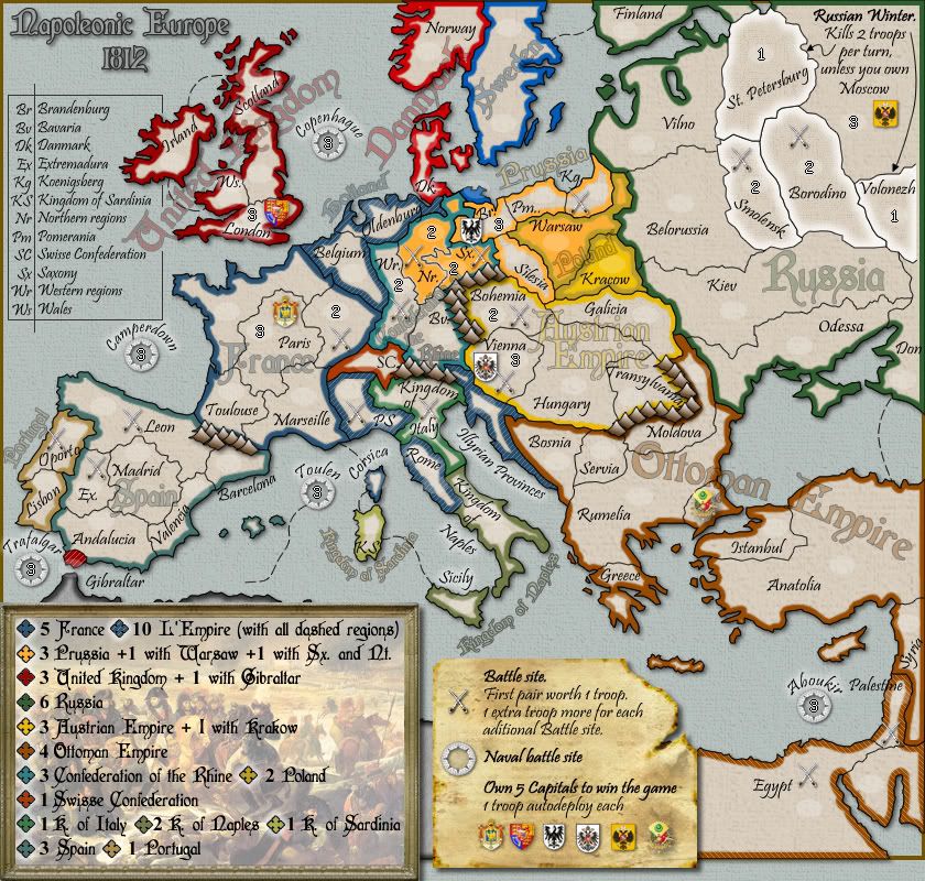
Countries (number of territories) - L’Empire : Empire Francais (10), Spain (7), Italy (4), Rhine Confederation (6) Duchy of Poland (2), Illyrian Provinces (1) Kingdom of Rome (1),
Countries-Coalition: United Kingdom (6), Prussia (6), Austrian Empire (7), Russian Empire (10), Gibraltar (1) Malta (1) Portugal (2)
Countries-Neutral: Sweden (4), Turkish Empire (10)
Naval Battles: (8)
Total: 84

Capitals – L’Empire: Paris, Madrid, Naples, Munich
Capitals – La Coalition: London, Moscow, Berlin, Vienna
Capitals – Neutrals: Stockholm, Istanbul

Naval battles (XX): Toulon, Camperdown, Cape St. Vincent, Santa Cruz, The Nile,
Copenhagen, Boulogne, Trafalgar
Land battles (X): Italy: Marengo, Rivoli,
France: Chateau-Thierry, Toulouse
Spain: Badajoz, Salamanca
Germany: Ulm, Leipzig
Austria: Wagram, Austerlitz
Prussia: Jena, Friedland
Russia: Smolensk, Borodino
Belgium: Waterloo
Portugal: Oporto
Turkish Empire: Pyramids, Acre

Win: Control of Capitals of all opposing powers; Control of all land battles

Bonuses: Empire Francais, Russian Empire: 7
(Free) Austrian Empire, Iberian Peninsula: 5
Rhine Confederation, Prussia, UK, Turkish Empire: 4
Italy, Sweden, 3
UK + Gibraltar: +1
UK + Malta: +1
UK + Cyprus: +1
UK+Portugal (2): +1
Empire + Poland (2): +1
Empire + Illyrian Provinces: +1
Empire + Kingdom of Rome: +1

Each capital: +1 (Automatic)
3 Naval battles: +1 (Free)
6 Naval battles: +2
8 Naval battles: +4
3 Land battles: +1
5 Land battles: +2
8 Land battles: +3
10 Land battles: +4
12 Land battles: +5
14 Land battles: +6
16 Land battles:+8
18 Land battles: Win

Rhine Confederation: Duchy of Mecklemburg, Kingdom of Saxony (X Leipzig), Kingdom of Westphalia, Rhine-Mainz Duchies, Kingdom of Wurtemberg (X Ulm), Kingdom of Bavaria / Munchen

Austrian Empire: Bohemia, Moravia (X Austerlitz), Austria (X Wagram), Vienna, Styria, Galicia, Hungary

Kingdom of Prussia: Berlin, Brandenburg (X Jena), Pomerania, Upper Silesia, Lower Silesia, Western Prussia (X Friedland)

United Kingdom: London, England, Scotland, Wales, Ulster, Ireland, (Gibraltar, Malta)

Kingdom of Sweden: Sweden / Stockholm; Norway, Danemark (XX Copenhagen), Swedish Pomerania

Duchy of Poland: Posen, Warsaw

Turkish Empire: Moldavia, Walachia, Serbia, Rumelia, Greece, Istanbul, Anatolia, Syria, Palestine (X Acre) Egypt (X Pyramids, XX Aboukir)

Italy: Kingdom of Italy (X Rivoli), Kingdom of Naples-Two Sicilies, Switzerland (X Marengo), Naples

Russian Empire: St. Petersburg, Moscow (X Borodino), Ukraine, Belorussia (X Smolensk), Baltic Countries, Finland, Bassarabia, Caucasus, Crimea, Kazan

Empire Francais: Paris, Boulogne (XX French Fleet) , Lyon, Toulon (XX Toulon Blocade), Toulouse (X Toulouse), Alsace-Lorraine (X Chauteau-Thierry), Corsica, Belgium (X Waterloo), Batavia (XX Camperdown), Oldenburg

Kingdom of Rome

Illyrian Provinces

Spain: Barcelona, Madrid, Salamanca (X Salamanca), Badajoz (X Badajoz), Cadiz (XX Trafalgar), Andalusia, Balearics (XX Santa Cruz),

Kingdom of Portugal: Lisbon (XX St. Vincent), Oporto (X Oporto)

Thanks!

Re: Napoleonic Europe Map Proposal

PostPosted: Sun Sep 20, 2009 8:21 pm
by Industrial Helix
Image

I dunno if this will help, but I got the map at home and its great. CC needs a Napoleonic Wars map for sure, I think you just need to turn this map into an image.

Re: Napoleonic Europe Map Proposal

PostPosted: Sun Sep 20, 2009 8:27 pm
by the.killing.44
I was working on a draft for this, I'd love to collaborate :)

Re: Napoleonic Europe Map Proposal

PostPosted: Sun Sep 20, 2009 9:06 pm
by Raskholnikov
Hi Helix,

Thanks for the Risk map! However, it represents Europe in about 1789, before the Napoleonic conquests, and even so it distorts history and geography: Italy was not united, neither was there a Confederation of the Rhine, and all of German Central Europe is squeezed in a bizzare way that makes it look smaller. I am really interested in a map of Europe at the peak of the Napoleonic Era, at the start of the Russian Campaign.

Thanks again for the map, it is a beginning ;)

Re: Napoleonic Europe Map Proposal

PostPosted: Sun Sep 20, 2009 9:13 pm
by Raskholnikov
Hello the.killing.44,

I'd love to work with you. How do you propose to proceed? I'l love to get a rough draft of the map with all the provinces, cities ,battles and frontiers in the right place first, and then work to refine and improve it.

Look forward to hearing from you.

Re: Napoleonic Europe Map Proposal

PostPosted: Mon Sep 21, 2009 10:20 am
by Raskholnikov
That's a very rough outline of what I had in mind:

Image

Re: Napoleonic Europe Map Proposal

PostPosted: Mon Sep 21, 2009 11:14 am
by Kabanellas
A map of Napoleonic Europe was in my mind for quite a long time.... Europe in 1800 to be more precise.

I'd very much like to participate :)

Re: Napoleonic Europe Map Proposal

PostPosted: Mon Sep 21, 2009 4:23 pm
by Raskholnikov
Hello Kabanellas,

Thank you for your kind offer. I'd love your help and input - especially after seeing the amazing work you've done with your Cruisade map!

As you can see, the (very!) rough map I drew is that of Europe in 1812 - just as the troops oif La Grande Armee were massing on the border of the Russian Empire.

If you wish, since it seems you have the tools, you could do a first (good) draft version of the map. Please note that I did the borders most internal territories (France, Spain, Portugal, etc) by hand and I'm totally open to having them modified to make sure they more accurately represent the borders of historical regions at the time.

A few words about battles:

Land battles (to be represented by crossed swords with a number next to it: 1 to 18) are part of territorial regions. Depending on how many you own, you get bonuses. There are 18 of them (2 in each "country). In my rough map they are represented by X es. We may have to tweak them a bit to make sure they are placed in the historical right territories, but that's feasable since the Empereur has so many battles that if one doesn't fit we can replace it with another that does.

The dates of the land battles are as follows:

Rivoli - January 1797: Northern Italy, just under Tyrol (but for game balance I'd like to place it in Southern Switzerland)
Pyramids: July 1798 - Egypt
Jaffa - March 1799: Palestine
Marengo: June 1800: Northern Italy, above Genova.
Ulm: October 1805 - Wurtemberg
Austerlitz: December 1805, Bohemia
Jena: October 1806: Thuringen- Westphalen
Friedland - June 1807: Eastern Prussia
Wagram: July 1809: Austria, north of Vienna
Oporto: May 1809, Northern Portugal
Badajoz: March 1812 - Spain at border with Portugal
Salamanca: July 1812, north of Badajoz
Smolensk: August 1812, Belorussia
Borodino: September 1812 - west of Moscow
Leipzig: October 1813- Kingdom of Saxony
Chateau-Thiery - February 1814: north of Paris
Toulouse: April 1814 - south-eastern France
Waterloo: June 1815, Belgium

Naval battles work as "sea territories" which can be conquered and give bonuses (to be represented by a period ship with a number from 1 to 8 on it). This makes a French Egypt campaign possible, and allows opponents to block it. Same idea for a British landing in Portugal. And most importantly, it brings the entire 10 provinces of the ottoman Empire much better into play.

The dates of the naval battles are as follows:

N1: Siege of Toulon: December 1793: - off southern France
N2: Battle of Genoa: 1795 - off the coast of Northern Italy (not shown on my rough draft; needs placing)
N3: Cape St. Vincent: February 1797: - off the coast of southern Portugal;
N4: Camperdown: October 1797 - off the coast of Holland;
N5: Battle of the Nile (Aboukir): August 1798 - off the coast of Egypt
N6: Copenhagen: April 1801 - off the coast of Copenhagen, Danemark
N7: Raid on Boulogne: October 1804 - off Northern France (British Channel)
N8: Trafalgar: October 1805 - off Cadiz, Spain

I eliminated the battle of Santa Cruz de Tenerife, since it is not possible to show it on our map. The battle shown next to the Balearics is a mistake and must be deleted.

Finally, capitals. I thought major capitals should be somewhat sheltered, like Paris in the Europe 1914 map, so that there will always be a 1 province buffer between the country's capital and any of its external borders. This may or may not work - we can only decide once we have a draft.

Re: Napoleonic Europe Map Proposal

PostPosted: Mon Sep 21, 2009 6:42 pm
by Kabanellas
Thanks!!

let me carefully analyse all your inputs tomorrow. hope I find time for it :)

I predict an Epic here.... anyway, I'd like to wait on a word from Killing, since he has shown interest on doing it too....

but Rask, I might add that I like the way you're going here, and it really makes me comfortable knowing that you have such an high knowledge of all this historical background.

Re: Napoleonic Europe Map Proposal

PostPosted: Mon Sep 21, 2009 8:37 pm
by Raskholnikov
Thank you Kabanellas. I look forward to doing this with you.

Because we will have about 84 territories, I think we should use as model Qwert's WWII map, give a code to every territory (like I did in my rough draft) and have the actual name displayed only on the attack/ defence drop-down menus. I had a chat with Qwert and he thinks this is an interesting and feasable project, although quite difficult.

Tnanks again for your help and i look forward to seeing your first draft whenever you get around to it!

Re: Napoleonic Europe Map Proposal

PostPosted: Mon Sep 21, 2009 9:02 pm
by Industrial Helix
I think the confederation of the Rhine reflects Napoleon's reorganization of the HRE. An yeah, Italy isn't united on the map by name, but its grouped to make continent bonus. Personally I like it but I think you're going for something more ambitious.

So let me express my opposition to giving every terr. a code. Honestly, I can barely wade my way through the WWII Europe map. I hope you don't go down that road, but if you do, it will def. fill a niche in CC. Looking forward to more!

Re: Napoleonic Europe Map Proposal

PostPosted: Mon Sep 21, 2009 9:30 pm
by Raskholnikov
I totally understand your opposition to giving territories codes. The problem is sheer size: with 84 territories. it will be hard not to do so and still keep it reasonably clear. But I'm totally open to trying it with names and see what works best!

Re: Napoleonic Europe Map Proposal

PostPosted: Mon Sep 21, 2009 9:39 pm
by Evil DIMwit
I actually like the coding scheme in WWII Europe -- it's very handy to have all the territories organized by region in the drop-down, and to be able to identify them.

The only flaw I see with this map is, in my eyes, that it's about Europe. Other than that it seems like a pretty exciting map.

Re: Napoleonic Europe Map Proposal

PostPosted: Mon Sep 21, 2009 10:10 pm
by Raskholnikov
Thank you for your comments Evil. I guess some people like the drop-downs with territory names, others like to see them on the map. My main concern is clarity and ease of use - so once we have a draft, we will be in a better position to judge.

Actually I think that integrating into the game Napoleon's Egyptian campaign as well as the naval battles gives it a bit of an extra-European dimension. But yes, i take your point- it IS a map about Napoleonic Europe.... ;)

Re: Napoleonic Europe Map Proposal

PostPosted: Tue Sep 22, 2009 8:38 am
by Industrial Helix
Evil DIMwit wrote:I actually like the coding scheme in WWII Europe -- it's very handy to have all the territories organized by region in the drop-down, and to be able to identify them.

The only flaw I see with this map is, in my eyes, that it's about Europe. Other than that it seems like a pretty exciting map.


Yeah, I dunno if its so much about the codes, cause I get along fine on Omaha Beach and some other games with codes. I think it might just be the colors and what not on the map. It's kind of like someone spilled a bucket of paint on a europe shaped piece of paper. I think if I could recognize the area I wanted to work with as Poland or West Germany then I might have a better chance of remembering where the territories are and being able to operate a smooth game.

Anyway, I need to stop talking about WWII Europe, its kind of rude.

I look forward to seeing your ideas put into an image!

Re: Napoleonic Europe Map Proposal

PostPosted: Wed Sep 23, 2009 1:09 pm
by the.killing.44
Have I been kicked from this? I went on a school trip Mon-Wed so you didn't hear from me…

Re: Napoleonic Europe Map Proposal

PostPosted: Thu Sep 24, 2009 5:36 am
by Kabanellas
Kabanellas wrote:Thanks!!

let me carefully analyse all your inputs tomorrow. hope I find time for it :)

I predict an Epic here.... anyway, I'd like to wait on a word from Killing, since he has shown interest on doing it too....

but Rask, I might add that I like the way you're going here, and it really makes me comfortable knowing that you have such an high knowledge of all this historical background.


Hi Killing :) ... Actually I was waiting for a word from you.

in the mid time I did advance with some ideas/sketches... I'll share with you all very soon.

Re: Napoleonic Europe Map Proposal

PostPosted: Fri Sep 25, 2009 1:28 pm
by Raskholnikov
Of course you haven't! We are very happy to have you in our team!

Re: Napoleonic Europe Map Proposal

PostPosted: Wed Oct 07, 2009 2:13 am
by Kabanellas
just a taste of the work is being done:

Click image to enlarge.
image

Re: Napoleonic Europe Map Proposal

PostPosted: Wed Oct 07, 2009 6:32 am
by Industrial Helix
Oh wow... this is going to be awesome.

Re: Napoleonic Europe Map Proposal

PostPosted: Wed Oct 07, 2009 1:58 pm
by Evil DIMwit
Dang. That is one impressive map.

Re: Napoleonic Europe Map Proposal

PostPosted: Wed Oct 07, 2009 2:08 pm
by danryan
I don't usually say much, but this is my number one wishlist map. Looks beautiful already, going to be a blast.

Re: Napoleonic Europe Map Proposal

PostPosted: Wed Oct 07, 2009 3:26 pm
by ender516
Oh, I like this, especially the stylistic elements which resemble your Third Crusade map. Quibble: The colour for the United Kingdom and Danmark are a bit too similar considering their proximity, but I suspect that overall, you are trying to use colours from flags, so I won't say anything more.

Re: Napoleonic Europe Map Proposal

PostPosted: Wed Oct 07, 2009 8:04 pm
by captainwalrus
What font are you using for the bonus region names. I really like it.

Re: Napoleonic Europe Map Proposal

PostPosted: Wed Oct 07, 2009 8:11 pm
by the.killing.44
Click image to enlarge.
image


Not that it's near finished. I'm using Isabella for that font. Blend Mode: Normal; Layer Opacity: 25%; Stroke: 1px, outside, 100% opacity.