Conquer Club

High Seas [Quenched]

Care to peruse completed maps? Take a stroll through the Atlas.

Moderator: Cartographers

Forum rules
Please read the Community Guidelines before posting.

Postby oaktown on Wed Feb 20, 2008 9:33 am

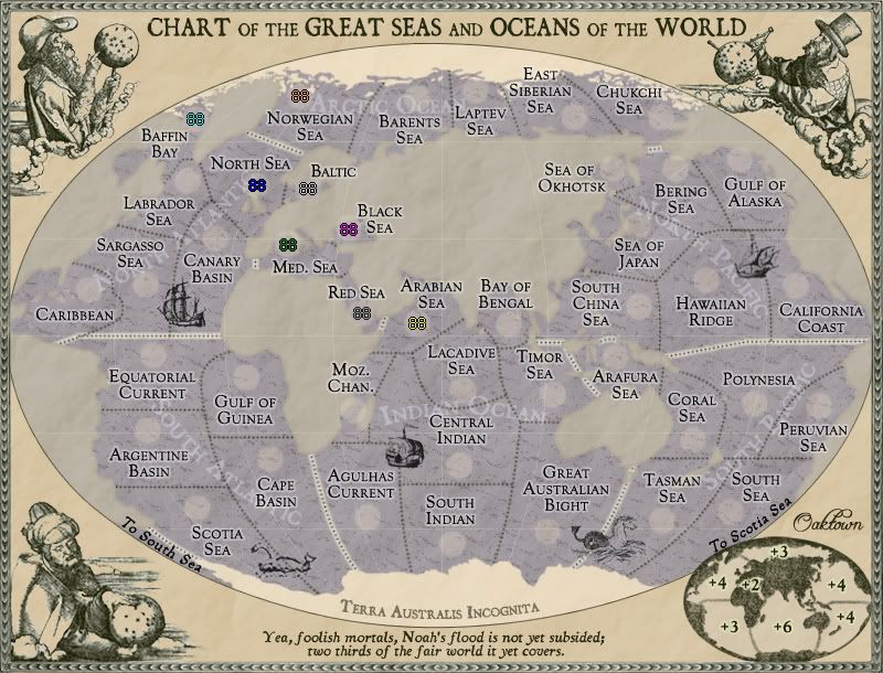
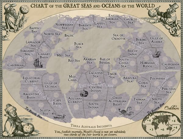
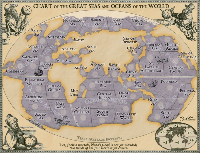
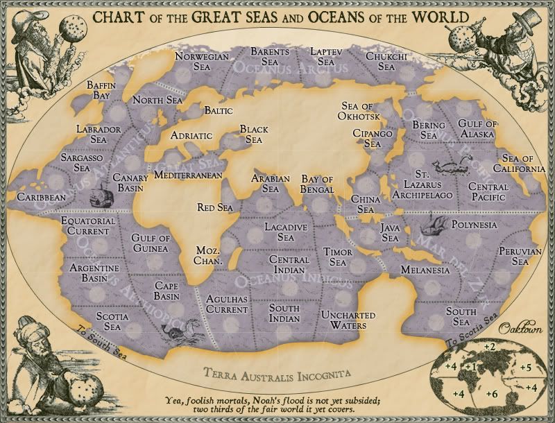
Incandenza wrote:The first problem I have is that there was no Suez Canal back then, and thus no Med-Red connection. Oddly enough, this could work in your favor. Conceptually the three Great Seas (which I think would work fine as a continent name) are all part of the same trading axis, especially given the age of empires that this map suggests. So you could keep Red as part of the continent, but cut off the connection and make the continent non-contiguous (and prolly bump the bonus up one), nicely simulating the whole "shit, we have to sail around half the goddamn world to get these trinkets from genoa to djibouti."

For starters, the Suez Canal is a 19th century reality, having opened in the 1860s. By closing it off, I'd be creating two dead-ends on the map, and while I know that dead ends aren't necessarily bad things I feel that with the impassable Americas there is already a big barrier to open play. I'm open to the idea, but I'd like to hear more folks chime in on this one.

Incandenza wrote:Also the borders are perhaps too crisp for a period map. More to the point, Antarctica is waaaay too crisp. Seems like a perfect point to indulge in some creative license and have either a large "here be dragons" bit (perhaps a bit too old-timey for this map), or an speculative blob labeled Terra Australis (given the fact that the continent was still largely unmapped as late as the mid 20th century).

Hmm... this could be fun. I was originally going to take some liberty with Australia and the Pacific Coast of the Americas (remember when California was an islands??) but I feared that I'd get a deluge of comments telling me my map was all wrong!

Incandenza wrote:Speaking of pure gameplay, I don't recall how the previous mapmaker used the 'doldrums' concept, but if we're talking 19th century here, the doldrums could be used as unpassables, given that the doldrums are areas of weak, intermittent winds notorious for impeding the progress of sailors. I noticed that you abandoned the concept early on, but to be honest I think you might have given it short shrift.

Yeah, I never liked it in the original project. He threw that in there because he had so many border territories along the equator, a problem which I don't think my version of the map has. I don't like impassables for the sake of having impassables - other solutions are preferable.
User avatar
Captain oaktown
 
Posts: 4451
Joined: Sun Dec 03, 2006 9:24 pm
Location: majorcommand

Postby Sir. Ricco on Wed Feb 20, 2008 2:43 pm

I really like the map. I think it will be fun to play.
But one thing that might be cool is add famous ports.
Image
Image
Image
User avatar
Captain Sir. Ricco
 
Posts: 4555
Joined: Tue Oct 02, 2007 2:33 pm
Location: Making kingdoms burn and bloodshed start.

Postby Incandenza on Wed Feb 20, 2008 3:30 pm

Oops, you're right about the suez canal (for some reason my brain refuses to properly remember when the damn thing opened). :oops:

As far as the coastlines, while I think it would be cool to work with australia and california, by the 19th century those two coastlines were reasonably well mapped. But I do think you could have fun with antarctica... and with how stylized the map is, I doubt too many people would complain about the accuracy.
THOTA: dingdingdingdingdingdingBOOM

Te Occidere Possunt Sed Te Edere Non Possunt Nefas Est
User avatar
Colonel Incandenza
 
Posts: 4949
Joined: Thu Oct 19, 2006 5:34 pm
Location: Playing Eschaton with a bucket of old tennis balls

Postby oaktown on Thu Feb 21, 2008 12:04 am

Image
Image

Just little stuff, and I thought I'd see what the small map might look like.
User avatar
Captain oaktown
 
Posts: 4451
Joined: Sun Dec 03, 2006 9:24 pm
Location: majorcommand

Postby whitestazn88 on Thu Feb 21, 2008 12:48 am

to name the Mediterranean etc, i think you could call it like inland europe, and just put the name right below in africa or something
Lieutenant whitestazn88
 
Posts: 3128
Joined: Mon Feb 05, 2007 2:59 pm
Location: behind you

Postby jasnostj on Thu Feb 21, 2008 11:36 am

Incandenza wrote:Oops, you're right about the suez canal (for some reason my brain refuses to properly remember when the damn thing opened). :oops:

As far as the coastlines, while I think it would be cool to work with australia and california, by the 19th century those two coastlines were reasonably well mapped. But I do think you could have fun with antarctica... and with how stylized the map is, I doubt too many people would complain about the accuracy.


Hi there. I love the concept, carry on! Don't we all want to be pirates conquering the world seas? Argh!

As to Incadenza's comments:

Suez canal: I do like the idea to not have it (yet) and having to sail all around Africa to get from the Mediterranean (or North Atlantic) to the Red Sea (or Indian Ocean). That was a very big deal for a very large part of maritime history.

Doldrums: Once again great idea. They WERE impassable before steam-powered ships appeared on the world's oceans. This is not a case of impassables solely to improve gameplay (some good examples of that can be found on the Brazil map, yes those are fictitious mountains!), the doldrums were a reality in the 1800's and inclusion would be great for the map's theme.

Antarctica: The white colour contributes to the crispness, and the name on your last update makes it stand out even more (none of the other continents have names). I understand the colour is the same as the ice on the north pole, but why not draw the floating ice around Antarctica then as well? That would mask the actual outline of the continent, which was indeed unknown in the 1800's (it turned out very similar to some ancient maps of Atlantis when it was discovered, but that's a whole different subject).

If you going to fool around with floating ice anyway, I would make the arctic ice sheet bigger and the Arctic Ocean territories smaller, and maybe even discontinue the Arctic Ocean somewhere north of Siberia. Like it is now, your map could be called Extreme Global Warming 2.0, and poor Willem Barentsz wouldn't have died on Nova Zembla trying to find a way around the north of Asia.

Besides I agree with Incadenza that it would be nice if the outlines of the continents would look less modern (no sattelites yet in the 1800's).
Last edited by jasnostj on Fri Feb 22, 2008 5:34 am, edited 1 time in total.
User avatar
Private jasnostj
 
Posts: 146
Joined: Tue May 29, 2007 6:57 am

Postby oaktown on Fri Feb 22, 2008 1:22 am

I'm thinking I may overhaul the territories completely. While I'm still no fan of the doldrums idea, the map is desperately in need of some barriers. I just typed up the XML, and there are too many territories that border five or six other territs - just about everything in the wide Indian and Pacific oceans.

If I went with an older, more screwed up map of the earth, it would net the following benefits:
ā€¢ I could knock out a passage or two, by losing the Suez Canal and doing something really old-school like connecting Australia and Antarctica.
ā€¢ I could do whatever the hell I wanted with the land - like making Europe really big and adding more elements to the Med. I'd like to have the Adriatic as a territory, and make the Med a 3 territory +1, while the Red Sea would go more appropriately with the Indian Ocean.
ā€¢ It would be in keeping with the Durer images if I go 16th Century, rather than 19th century.

I don't think I could lose the northern passage as well as the Suez - then there would be just two bottlenecks splitting the map in two, and I'd like the gameplay to be a bit more open.

here are some links to 16th century maps I'll be borrowing from...
http://www.smh.com.au/ffximage/2006/09/ ... main,0.jpg
http://rare-maps.biz/shop_image/product ... 0e49ef.jpg
http://academic.emporia.edu/aberjame/ma ... _map09.jpg
User avatar
Captain oaktown
 
Posts: 4451
Joined: Sun Dec 03, 2006 9:24 pm
Location: majorcommand

Postby jasnostj on Fri Feb 22, 2008 5:00 am


I think the first one would be excellent! It has all the passages you need, including the Northern one. I like the connection of Australia and Antarctica as another impassable, cool. The Mediterranean could easily be divided into 3 ters on that one.

How about adding the Caspian (very visible, and distorted, on this map) as a little gimmick? You are f**ked if you get initial placement there, or not because nobody can touch you there. Could have a +1 bonus or some other small advantage to compensate for the isolation. It could turn neutral if the owner loses its last other territory.
User avatar
Private jasnostj
 
Posts: 146
Joined: Tue May 29, 2007 6:57 am

Postby Lone.prophet on Fri Feb 22, 2008 7:22 am

i think you should darken the land a bit so the contrast with the water isnt so low
Image
Captain Lone.prophet
 
Posts: 1467
Joined: Thu Oct 12, 2006 4:37 pm
Location: Your basement Muahaha

Postby oaktown on Sat Feb 23, 2008 3:24 am

Image
So, it's a bit different now.

Still 42 territories, but I've moved things around to allow for better play. Now we have two little territories for folks to go after early, with the middle seas being a +1 with just the one border, and the Arctic now a +2 since I've knocked out a territory.

The graphics made this possible - I've stepped back in time to the 16th Century, when maps were still being printed based on reports by people who had never actually been to the places they wrote about. California is an island, Australia isn't. The shape of everything is a bit, well, wrong, and when I'm less sleepy I intend to make it more-so.

I obviously have made more work for myself - the little inset map has to be redone, the northern ice looks out of place, etc. Feel free to tell me what should stay/go and I'll start a to-do list.
User avatar
Captain oaktown
 
Posts: 4451
Joined: Sun Dec 03, 2006 9:24 pm
Location: majorcommand

Postby cairnswk on Sat Feb 23, 2008 3:26 am

Luv it Oaktown! Very professional! Congrats on obtaining such style. :)
Image
* Pearl Harbour * Waterloo * Forbidden City * Jamaica * Pot Mosbi
User avatar
Private cairnswk
 
Posts: 11510
Joined: Sat Feb 03, 2007 8:32 pm
Location: Australia

Postby fumandomuerte on Sat Feb 23, 2008 3:40 am

totally love it. Would play it as it is but I think a bonus of +5 to the Oceanus indicus would be more fair.

Waitin' to see it Quenched...
User avatar
Captain fumandomuerte
 
Posts: 620
Joined: Sat Dec 29, 2007 1:27 am
Location: The Cinderella of the Pacific

Postby gimil on Sat Feb 23, 2008 11:14 am

The only issue I see id the fact that the land seems to stick out more htan the sea. I have a feeling though that this will subside once army numbers are placed. Could I please see a draft with army numbers please :)
What do you know about map making, bitch?

natty_dread wrote:I was wrong


Top Score:2403
User avatar
Corporal 1st Class gimil
 
Posts: 8599
Joined: Sat Mar 03, 2007 12:42 pm
Location: United Kingdom (Scotland)

Postby oaktown on Sat Feb 23, 2008 12:58 pm

the land is a work in progress... I'm going to break it up with some rivers and landforms so it won't be a solid field that pops out so much.
User avatar
Captain oaktown
 
Posts: 4451
Joined: Sun Dec 03, 2006 9:24 pm
Location: majorcommand

Postby gimil on Sat Feb 23, 2008 12:59 pm

oaktown wrote:the land is a work in progress... I'm going to break it up with some rivers and landforms so it won't be a solid field that pops out so much.


In that case ignore me :)
What do you know about map making, bitch?

natty_dread wrote:I was wrong


Top Score:2403
User avatar
Corporal 1st Class gimil
 
Posts: 8599
Joined: Sat Mar 03, 2007 12:42 pm
Location: United Kingdom (Scotland)

Postby whitestazn88 on Sat Feb 23, 2008 1:36 pm

i was more in favor of the original for the reason of the colors, but i guess what you said to gimil will settle that
Lieutenant whitestazn88
 
Posts: 3128
Joined: Mon Feb 05, 2007 2:59 pm
Location: behind you

Postby edbeard on Sun Feb 24, 2008 1:30 am

well the names of the continents were more readable in the older version. Or, at least I remember them being clearer.

The Sea Of California territory doesn't appear to have a border on the west.

The problem with your current setup from a visual p.o.v. is that the continent separation for Mar Del Zur could be confusing. Though, I think you're still working on all the graphics.

I like the two small continents you have now. Those will work quite well.


One observation, you can hold the Seas continent and Oceanus Atlantic with two territories now.

It does seem a bit strange to have a +6 that only has 3 borders. I'm not sure it's bad since it requires 10 territories to hold and expansion is difficult.


I hope the land goes back to the previous update look (bottom page 8). Those colours meshed well together.
User avatar
Lieutenant edbeard
 
Posts: 2501
Joined: Thu Mar 29, 2007 12:41 am

Postby oaktown on Sun Feb 24, 2008 11:02 am

edbeard wrote:well the names of the continents were more readable in the older version. Or, at least I remember them being clearer.

right, they'll need to be moved around, and perhaps the color changed for clarity. I still contend that the continent names aren't really necessary for gameplay - but if I took out the names it might blow people's minds. ;)

edbeard wrote:The Sea Of California territory doesn't appear to have a border on the west.

there is one, but both borders are with the same territory - the central pacific. In placing the terit name I didn't worry too much about where it went, since the second border was redundant, but I guess it would be more clear if you could see both.

edbeard wrote:The problem with your current setup from a visual p.o.v. is that the continent separation for Mar Del Zur could be confusing. Though, I think you're still working on all the graphics.

Yeah, I don't like the western border there much either. I'll take more liberties with actual geography and make the continent separations more logical. This will actually be a pretty easy fix.

edbeard wrote:One observation, you can hold the Seas continent and Oceanus Atlantic with two territories now.

It does seem a bit strange to have a +6 that only has 3 borders. I'm not sure it's bad since it requires 10 territories to hold and expansion is difficult.

Hmm, we may miss the Red Sea connection after all, since it opened up the two sides of the world to each other. A fix will probably probably mean adding another border territory to Aethiopicus, and bumpingit up to a +4 like Zur. Leaving it alone will mean that one lucky player may be able to build out to hold an eleven territory+5 bonus with two borders (which isn't terrible really), and then a 15 territory +7 with just two borders. Ick. I'll extend the Guinea border north to meet Canary.

As for the 10 terits, 3 borders, +6: I think this is in line with the classic game, in which N. America has 9 terits, 3 borders, an easy expansion, and +5.

edbeard wrote:I hope the land goes back to the previous update look (bottom page 8). Those colours meshed well together.

Really? I didn't much like the greyish land - the land is a work in progress, so let's address this later.
User avatar
Captain oaktown
 
Posts: 4451
Joined: Sun Dec 03, 2006 9:24 pm
Location: majorcommand

Postby oaktown on Sun Feb 24, 2008 12:44 pm

Image
Ugh,I promised myself I would not wake up this morning and spendan hour on stuff. Oh well. This update reflects the gameplay changes discussed above, plus I've redone the inset map.

Note that I have not made any significant graphical changes to this version - that's still to come.
User avatar
Captain oaktown
 
Posts: 4451
Joined: Sun Dec 03, 2006 9:24 pm
Location: majorcommand

Postby unriggable on Sun Feb 24, 2008 5:10 pm

Badass.
Image
User avatar
Cook unriggable
 
Posts: 8037
Joined: Thu Feb 08, 2007 9:49 pm

Postby gimil on Sun Feb 24, 2008 5:36 pm

Oaktown found an intresting fact, did you know hippos are colorsblind? Is your avatar a coicidence? Or did you know this already?

As always though your graphics are the sort of thing that set te standards around here
:)
What do you know about map making, bitch?

natty_dread wrote:I was wrong


Top Score:2403
User avatar
Corporal 1st Class gimil
 
Posts: 8599
Joined: Sat Mar 03, 2007 12:42 pm
Location: United Kingdom (Scotland)

Postby Guiscard on Sun Feb 24, 2008 5:51 pm

Brilliant. Tried for a good five minutes to fine something to comment on other than that to no avail...
qwert wrote:Can i ask you something?What is porpose for you to open these Political topic in ConquerClub? Why you mix politic with Risk? Why you not open topic like HOT AND SEXY,or something like that.
User avatar
Private 1st Class Guiscard
 
Posts: 4103
Joined: Fri Dec 08, 2006 7:27 pm
Location: In the bar... With my head on the bar

Postby edbeard on Sun Feb 24, 2008 7:29 pm

It'd be nice if there was a +3 area, but I think the setup you have is nice now.


Except their surrounding continents, Oceanus Aethiopicus and Mar del Zur are pretty much the same continent.

5 territories, 4 bordering, 5 territories can attack them, and the same bonus obviously.

I'm not saying it's good or bad. Just an observation.


You're not getting a stamp just yet. Let's see some more discussion on the gameplay.
User avatar
Lieutenant edbeard
 
Posts: 2501
Joined: Thu Mar 29, 2007 12:41 am

Postby oaktown on Mon Feb 25, 2008 1:31 am

edbeard wrote:It'd be nice if there was a +3 area, but I think the setup you have is nice now.

Except their surrounding continents, Oceanus Aethiopicus and Mar del Zur are pretty much the same continent.

5 territories, 4 bordering, 5 territories can attack them, and the same bonus obviously.

I'm not saying it's good or bad. Just an observation.

I agree - I'd rather see a +3 or two, and in my calculations both Aethiop and Zur come out about 3.5. But if I have to err high or low on those two, I'd rather err high - they'll both be far harder to hold than the two smaller regions, so we should provide some real incentive to go after them.

edbeard wrote:You're not getting a stamp just yet. Let's see some more discussion on the gameplay.

I'm not asking for one yet. You should be at least as hard on me as I have been on everybody else. :wink:

And you're so good at this ed, I'm thinking I should put you in charge of a couple more maps. :?:
User avatar
Captain oaktown
 
Posts: 4451
Joined: Sun Dec 03, 2006 9:24 pm
Location: majorcommand

Postby I GOT SERVED on Mon Feb 25, 2008 10:22 am

This is a very nice map, and I love the progress that it's made. The only thing I can really comment on is maybe embellishing the fact that the Mediterranean and the Red Sea don't touch each other.

Other than that, not really too much to comment on. Keep up the most excellent work!
Image


Highest score: 2512
Highest rank: 424
User avatar
Captain I GOT SERVED
 
Posts: 1532
Joined: Fri Jan 26, 2007 9:42 pm
Location: Good 'ol New England

PreviousNext

Return to The Atlas

Who is online

Users browsing this forum: No registered users