kick ass map!
And I liked the ocean in the background although I do see the above poster's point that it isnt very warlike.
World 2.0/1 Map [Quenched]
Moderator: Cartographers
![]() by sgapaulmyers on Mon Oct 02, 2006 12:25 am
by sgapaulmyers on Mon Oct 02, 2006 12:25 am
-
 sgapaulmyers
- Posts: 14
- Joined: Wed Sep 27, 2006 4:30 pm
- Location: northern kentucky
Quick update...
![]() by zim on Mon Oct 02, 2006 2:34 pm
by zim on Mon Oct 02, 2006 2:34 pm

Just a quick snapshot of my current thinking (at 600 pixels) with work still to be done to position circles, get text colours right, etc...
Updates mainly in south america; 1) changed split of Brazil as per Marvaddin's recommendation; Marv, I've updated the border but you didn't send naming ideas, are you cool with Amazonas/Brasillia? 2)Shrunk composition of Amazon sub-continent and modified Andes subcontinent to create more unaligned territories per Gavin's suggestion.
Still to do:
Fix circles and text at 600. Note to self and other future map makers: Do the 600 pixel version first and then scale up
Recalculate sub-continent and full continent bonuses. Weight sub-continents lower so that players are incented to agressively pursue full continents.
Solve Myanmar/Thailand/Indo-china/Malaysia congestion problem (probably have to merge one or more).
Correct spelling of Colombia.
Still unresolved:
Debate around whether all territories should be part of both a sub and a full continent.
Cheers,
Zim
-

zim
- Posts: 180
- Joined: Thu Jul 27, 2006 4:55 pm


![]() by happysadfun on Mon Oct 02, 2006 3:24 pm
by happysadfun on Mon Oct 02, 2006 3:24 pm
You were right the first time it's Colombia.
 Children, this is what happens to hockey players, druggies, and Hillary Clinton.
Rope. Tree. Hillary. Some assembly required.
-

happysadfun
- Posts: 1251
- Joined: Mon Jul 10, 2006 9:06 pm
- Location: Haundin at DotSco, Being Sad that Mark Green Lost in Suburban Wisconsin
![]() by happysadfun on Mon Oct 02, 2006 3:33 pm
by happysadfun on Mon Oct 02, 2006 3:33 pm
china: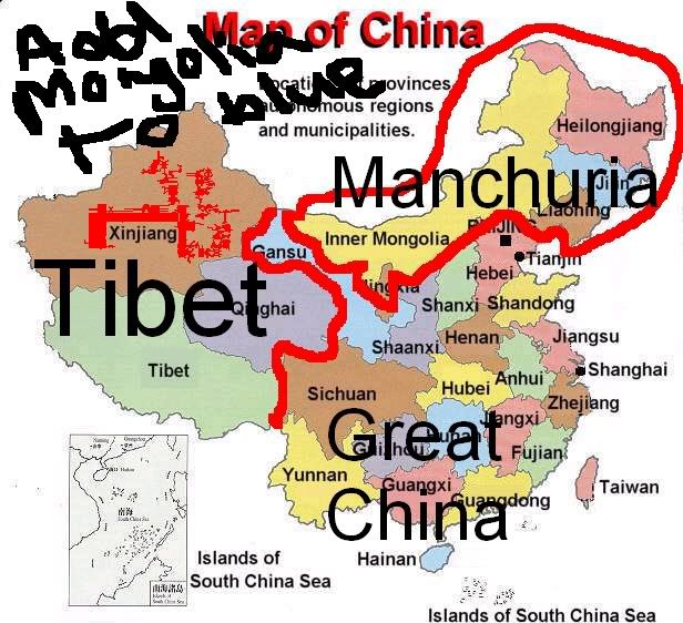 Add Mongolia!
Add Mongolia!Children, this is what happens to hockey players, druggies, and Hillary Clinton.
Rope. Tree. Hillary. Some assembly required.
-
happysadfun
- Posts: 1251
- Joined: Mon Jul 10, 2006 9:06 pm
- Location: Haundin at DotSco, Being Sad that Mark Green Lost in Suburban Wisconsin

Greater China, The Orient or The Far East
![]() by zim on Mon Oct 02, 2006 4:25 pm
by zim on Mon Oct 02, 2006 4:25 pm
happysadfun wrote:china:
Happy, if I add Mongolia to make a "Greater China" or a "Middle Kingdom" with Mongolia, China, Korea and Taiwan I'd need to remove Japan as it wouldn't fit the definition. Is this what you are suggesting or are you suggesting that Mongolia needs to be part of the blue territory and the expanded area renamed "The Far East" to encompas Japan, China, Mongolia, Korea and Taiwan?
I'm OK with either approach just want to be sure we're aligned before taking mouse to pixel.
Cheers,
Zim
-
zim
- Posts: 180
- Joined: Thu Jul 27, 2006 4:55 pm
Re: Quick update...
![]() by zim on Mon Oct 02, 2006 9:49 pm
by zim on Mon Oct 02, 2006 9:49 pm

zim wrote:Still to do:
Fix circles and text at 600. Note to self and other future map makers: Do the 600 pixel version first and then scale up
Done. I know things are pretty congested at this resolution but it's probably close to the best that can be done without significant surgery. I'm open to thoughts/suggestions that improve clarity ideally without removing territories.
zim wrote:Recalculate sub-continent and full continent bonuses. Weight sub-continents lower so that players are incented to agressively pursue full continents.
Done. Let me know what you all think about the bonus amounts.
zim wrote:Solve Myanmar/Thailand/Indo-china/Malaysia congestion problem (probably have to merge one or more).
Done, got rid of Myanmar and Malaysia.
zim wrote:Correct spelling of Colombia.
Done, Columbia is now Colombia
Cheers,
Zim
-
zim
- Posts: 180
- Joined: Thu Jul 27, 2006 4:55 pm
![]() by AndyDufresne on Mon Oct 02, 2006 9:53 pm
by AndyDufresne on Mon Oct 02, 2006 9:53 pm
The unfortunate thing about this map, the small map is just horrendous...due to the large area it must cover. Perhaps you can stretch the limit a little bit, and we'll see if we can find something that is still acceptable at the small level.
--Andy
--Andy
-

AndyDufresne
- Posts: 24919
- Joined: Fri Mar 03, 2006 8:22 pm
- Location: A Banana Palm in Zihuatanejo


![]() by DublinDoogey on Mon Oct 02, 2006 10:21 pm
by DublinDoogey on Mon Oct 02, 2006 10:21 pm
i dunno how decided it is, but i wanted to say that i think the white background aids legibility, while the water negates it.
-

DublinDoogey
- Posts: 329
- Joined: Tue Feb 28, 2006 7:03 pm
- Location: Wisconsin


Re: Quick update...
![]() by Marvaddin on Mon Oct 02, 2006 11:40 pm
by Marvaddin on Mon Oct 02, 2006 11:40 pm
zim wrote:Done, got rid of Myanmar and Malaysia.
Myanmar was a possible country, Taiwan is not. See, even now I cant know if its part of China subcontinent, imagine with a number over it.
Well, I think we should have only big version to this map, this way the smal one is being a trouble to the map development. Anyone with me?
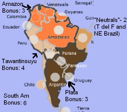
About Brazil, there are 3 geoeconomical areas: Amazon (Amazonia in Portuguese), that you called Amazonas, Northeast and Center-South (both form what you called Brasilia). For Brazilian Amazon, I think Amazonas is a good name, since its the name of that incredible river. Brazilian Amazon would be another option. The other area would be a South and East area, maybe called Eastern Brazil, or Southeastern Brazil, I dont have a good name to it. Since Brasilia is the capitol, maybe we can use it.
Anyway, South America subcontinents are totally unreal. If you want Amazonia and Andes, we will have problems. Colombia should belong to both... belong to none is terrible. So is Peru. So, maybe we can have Andes (including Colombia) and Plata, area with rivers Paraguay, Uruguay, Parana,... This should include Argentina, Uruguay, Paraguay and Brazilian Center-South. 2 problems, but easier than those in actual version: Argentina should belong to both (although its much more to Plata), and we would need change the way Brazil is splitted (we could call Center South "Parana", the name of another great river). The best way to divide, however, is between Amazon and Plata, alike that thing I suggested. Amazon should have Peru, Equador (? - I need check this), Colombia, Venezuela and Brazilian Amazon. No many problems here. And Andes, as its a narrow North-South area, will be a continent with many many borders. The single problem here is, what to do to Brazil Northeast area? Lets split Brazil in 3?
A tip: to avoid waste time and effort, dont calculate again the bonuses until we can decide how the continents will be, friend.
Edit: lol, I feel like a South America expert here... and in fact, compared to you guys, I probably am

-

Marvaddin
- Posts: 2545
- Joined: Thu Feb 09, 2006 5:06 pm
- Location: Belo Horizonte, Brazil


![]() by steve monkey on Tue Oct 03, 2006 2:07 pm
by steve monkey on Tue Oct 03, 2006 2:07 pm
I'm sorry for repeating myself because I've made this point before, but it wasn't acknowledged first time round. It is ridiculous to call a territory Rhodesia. This was the old colonial name for the country now known as Zimbabwe. The name of this territory does not fit in with the rest of the map. It would make sense to change it to something more appropriate.

May the dice gods shine favourably upon you.
-

steve monkey
- Posts: 490
- Joined: Sat May 13, 2006 5:25 pm
- Location: London


Re: Greater China, The Orient or The Far East
![]() by happysadfun on Tue Oct 03, 2006 3:14 pm
by happysadfun on Tue Oct 03, 2006 3:14 pm
zim wrote:....... Mongolia needs to be part of the blue territory and the expanded area renamed "The Far East" to encompas Japan, China, Mongolia, Korea and Taiwan?....
That one
Children, this is what happens to hockey players, druggies, and Hillary Clinton.
Rope. Tree. Hillary. Some assembly required.
-
happysadfun
- Posts: 1251
- Joined: Mon Jul 10, 2006 9:06 pm
- Location: Haundin at DotSco, Being Sad that Mark Green Lost in Suburban Wisconsin
Re: Quick update...
![]() by zim on Tue Oct 03, 2006 3:37 pm
by zim on Tue Oct 03, 2006 3:37 pm
Marvaddin wrote:...About Brazil, there are 3 geoeconomical areas: Amazon (Amazonia in Portuguese), that you called Amazonas, Northeast and Center-South (both form what you called Brasilia). For Brazilian Amazon, I think Amazonas is a good name, since its the name of that incredible river. Brazilian Amazon would be another option. The other area would be a South and East area, maybe called Eastern Brazil, or Southeastern Brazil, I dont have a good name to it. Since Brasilia is the capitol, maybe we can use it.
Anyway, South America subcontinents are totally unreal. If you want Amazonia and Andes, we will have problems. Colombia should belong to both... belong to none is terrible. So is Peru. So, maybe we can have Andes (including Colombia) and Plata, area with rivers Paraguay, Uruguay, Parana,... This should include Argentina, Uruguay, Paraguay and Brazilian Center-South. 2 problems, but easier than those in actual version: Argentina should belong to both (although its much more to Plata), and we would need change the way Brazil is splitted (we could call Center South "Parana", the name of another great river). The best way to divide, however, is between Amazon and Plata, alike that thing I suggested. Amazon should have Peru, Equador (? - I need check this), Colombia, Venezuela and Brazilian Amazon. No many problems here. And Andes, as its a narrow North-South area, will be a continent with many many borders. The single problem here is, what to do to Brazil Northeast area? Lets split Brazil in 3?
...
Edit: lol, I feel like a South America expert here... and in fact, compared to you guys, I probably am
Marvaddin;
Let me make sure I've got it before redrawing. Your recommendation is to keep the Andes subcontinent but to adjust it to include Chile, Bolivia, Peru, and Colombia. Ecuador would become 'neutral'. Second sub-continent is Plata with Argentina, Uruguay, Paraguay and 'southern' Brazil (currrently Brasillia but to be renamed Parana. Northern Brazil (Amazonas), Guyanas and Venuezuala would be neutral. If I've got it, I like it. Let me know if I've got it right and I'll update the borders.
steve monkey wrote:I'm sorry for repeating myself because I've made this point before, but it wasn't acknowledged first time round. It is ridiculous to call a territory Rhodesia. This was the old colonial name for the country now known as Zimbabwe. The name of this territory does not fit in with the rest of the map. It would make sense to change it to something more appropriate.
Sorry steve, I lost this one in the flurry of suggestions. I'll rename as Zimbabwe for the next version.
happysadfun wrote:zim wrote:....... Mongolia needs to be part of the blue territory and the expanded area renamed "The Far East" to encompas Japan, China, Mongolia, Korea and Taiwan?....
That one
Will do.
Cheers,
Zim
-
zim
- Posts: 180
- Joined: Thu Jul 27, 2006 4:55 pm
Re: Quick update...
![]() by Marvaddin on Tue Oct 03, 2006 5:18 pm
by Marvaddin on Tue Oct 03, 2006 5:18 pm
zim wrote:Marvaddin;
Let me make sure I've got it before redrawing. Your recommendation is to keep the Andes subcontinent but to adjust it to include Chile, Bolivia, Peru, and Colombia. Ecuador would become 'neutral'. Second sub-continent is Plata with Argentina, Uruguay, Paraguay and 'southern' Brazil (currrently Brasillia but to be renamed Parana. Northern Brazil (Amazonas), Guyanas and Venuezuala would be neutral. If I've got it, I like it. Let me know if I've got it right and I'll update the borders.
My recommendation, if two continents, is Plata and Amazon. If you want to maintain Andes, it should be Argentina (but it will be in Plata), Chile, Bolivia, Peru, Equador and Colombia. Plata is Argentina, Uruguay, Paraguay, and Southern Brail, but not as it is now, if so we need change Brazil split. If you want Amazon, it needs Venezuela, Colombia, Peru, Amazonas, Bolivia, and I will confirm if Ecuador will be part too.
-
Marvaddin
- Posts: 2545
- Joined: Thu Feb 09, 2006 5:06 pm
- Location: Belo Horizonte, Brazil
![]() by happysadfun on Tue Oct 03, 2006 6:30 pm
by happysadfun on Tue Oct 03, 2006 6:30 pm
I still think it would be good to have the Tawantinsuyu.
Children, this is what happens to hockey players, druggies, and Hillary Clinton.
Rope. Tree. Hillary. Some assembly required.
-
happysadfun
- Posts: 1251
- Joined: Mon Jul 10, 2006 9:06 pm
- Location: Haundin at DotSco, Being Sad that Mark Green Lost in Suburban Wisconsin
Re: Quick update...
![]() by zim on Tue Oct 03, 2006 9:48 pm
by zim on Tue Oct 03, 2006 9:48 pm
Marvaddin wrote:zim wrote:Marvaddin;
Let me make sure I've got it before redrawing. Your recommendation is to keep the Andes subcontinent but to adjust it to include Chile, Bolivia, Peru, and Colombia. Ecuador would become 'neutral'. Second sub-continent is Plata with Argentina, Uruguay, Paraguay and 'southern' Brazil (currrently Brasillia but to be renamed Parana. Northern Brazil (Amazonas), Guyanas and Venuezuala would be neutral. If I've got it, I like it. Let me know if I've got it right and I'll update the borders.
My recommendation, if two continents, is Plata and Amazon. If you want to maintain Andes, it should be Argentina (but it will be in Plata), Chile, Bolivia, Peru, Equador and Colombia. Plata is Argentina, Uruguay, Paraguay, and Southern Brail, but not as it is now, if so we need change Brazil split. If you want Amazon, it needs Venezuela, Colombia, Peru, Amazonas, Bolivia, and I will confirm if Ecuador will be part too.
Marvaddin, I think two is the right way to go; so Plata and Amazon it is.
Plata with Arrentina, Uruguagy, Paraguay and a newly drawn Southern Brazil called Parana.
Amazon with Venezuela, Colombia, Peru, Bolivia, Amazonas and Ecuador (I checked and whether we use the extent of the forest or the river basin both touch Ecuador). As an aside, if we choose the river basin as the definition Venezuela becomes neutral, do you think this is better or worse?
Can you let me know how you'd recommend drawing the Amazonas/Parana split?
happysadfun wrote:I still think it would be good to have the Tawantinsuyu.
Happysadfun, I'm not wedded to the Amazonas/Plata split, however my current thinking is to defer to Marvaddin's local knowledge. If you think Tawantinsuyu is a better answer let us know how you'd split things into it and a second subterritory leaving some 'neutrals' and we'll see if we can find a consensus.
Cheers,
Zim
-
zim
- Posts: 180
- Joined: Thu Jul 27, 2006 4:55 pm
![]() by Marvaddin on Tue Oct 03, 2006 11:23 pm
by Marvaddin on Tue Oct 03, 2006 11:23 pm
Im all up to know happy' suggestion of how to split countries.
Im suggesting Amazon (or Amazonia, your choice - is it really called Amazon in English, right?) and Plata (i can look for name alternatives) also because Andes would be a poor designed continent, with many many borders, almost all countries, in fact.
I think we should use the forest to create that subcontinent, and so Venezuela is in.
About the Brazilian division, there is no a good way to split the huge territory in 2 regions only.
3 main regions are:
Amazônia:
http://pt.wikipedia.org/wiki/Regi%C3%A3 ... _do_Brasil
Center-South (this is what I call Parana, or Paraná - accented in Portuguese):
http://pt.wikipedia.org/wiki/Regi%C3%A3 ... _do_Brasil
Northeast:
http://pt.wikipedia.org/wiki/Regi%C3%A3 ... _do_Brasil
This last region is not alike to any of the others, so more correct is not include in the others, and create another territory. How about it? If you dislike, well... its more to Center-South than to Amazonia, you can put the major part in Center South (Parana) - but again consider the idea of a new territory.
One more word: well, even if you use 3 regions for Brazil, the borders looks artificial (specially considering Center-South), maybe you can make minor changes to give them a more realistic aspect. This is a problem of this Wikipedia map, but I couldnt find another one better.
Last edited by Marvaddin on Wed Oct 04, 2006 12:34 am, edited 1 time in total.
-
Marvaddin
- Posts: 2545
- Joined: Thu Feb 09, 2006 5:06 pm
- Location: Belo Horizonte, Brazil
![]() by maritovw on Wed Oct 04, 2006 12:10 am
by maritovw on Wed Oct 04, 2006 12:10 am
Marvaddin wrote:Im suggesting Amazon (or Amazonia, your choice - is it really called Amazon in English, right?) and Plata (i can look for name alternatives) also because Andes would be a poor designed continent, with many many borders, almost all countries, in fact.
How about calling it South Cone instead of Andes or Plata?? that name is actually used to refer to that region.
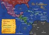 MIDDLE AMERICA MAP
-

maritovw
- Posts: 195
- Joined: Mon Jul 17, 2006 10:05 pm
- Location: Guatemala

![]() by ZawBanjito on Wed Oct 04, 2006 4:46 am
by ZawBanjito on Wed Oct 04, 2006 4:46 am
I'm completely lost in this discussion, but I just wanted to pipe in and say that I'm salivating to play this map. I haven't been this excited about a new map in ages. I also want to applaud zim for his dedicated work ethic that is really driving it forward. He's listening to all the input and the map is just looking top grade, man, just totally A+ Double Stuf. Keep up the good work!
-

ZawBanjito
- Posts: 379
- Joined: Mon Jan 23, 2006 12:25 am
- Location: Somewhere
![]() by zim on Wed Oct 04, 2006 4:38 pm
by zim on Wed Oct 04, 2006 4:38 pm
Updated small(ish) maps in two flavours (with and without waves).

and

Dublin; I'm with you that the waves I've tried so far are less clear than the white (though I'd still like to find a set that works because in my head they look really good). That being said a white background prevents me from using white text on any country name the spills over a border. I've posted another waves version and one with a flat blue background. I think the flat blue achieves the clarity of the white while letting me use white as a text colour. Let me know what you think...
Marv; I think this version captures your suggestion. Let me know if I've missed anything and what you think of the three way Brazillian split. I'd love an alternate name for the North East Brazil region though I understand if there isn't one that is both accurate and interesting.
Maritovw, I presume you mean for the Plata area as currently shown? If so I think Plata is a more interesting name and but I'm open to persuasion, show me a reference or two for South Cone and I'll think on it.
Zaw: Thanks for the kind words. I'm dieing to get beta testing too...
And to save Andy the trouble he will (rightly) say:
Cheers,
Zim
P.S. Does anyone know if it's possible and if so how to create another poll in this thread or do we need to create a new one? I'd like to get the "Wisdom of Crowds" on a title; "Real World, Modern World, World 2.0, Zim's World, Your Suggestion Here" (guess which one I think is best) and on the waves/no waves questions.
P.P.S. Just notices that Bolivia's title is messed up, will fix it in the next version.
and
DublinDoogey wrote:i dunno how decided it is, but i wanted to say that i think the white background aids legibility, while the water negates it.
Dublin; I'm with you that the waves I've tried so far are less clear than the white (though I'd still like to find a set that works because in my head they look really good). That being said a white background prevents me from using white text on any country name the spills over a border. I've posted another waves version and one with a flat blue background. I think the flat blue achieves the clarity of the white while letting me use white as a text colour. Let me know what you think...
Marvaddin wrote:Im all up to know happy' suggestion of how to split countries.
Im suggesting Amazon (or Amazonia, your choice - is it really called Amazon in English, right?) and Plata (i can look for name alternatives) also because Andes would be a poor designed continent, with many many borders, almost all countries, in fact.
I think we should use the forest to create that subcontinent, and so Venezuela is in.
About the Brazilian division, there is no a good way to split the huge territory in 2 regions only.
3 main regions are:
Amazônia:
http://pt.wikipedia.org/wiki/Regi%C3%A3 ... _do_Brasil
Center-South (this is what I call Parana, or Paraná - accented in Portuguese):
http://pt.wikipedia.org/wiki/Regi%C3%A3 ... _do_Brasil
Northeast:
http://pt.wikipedia.org/wiki/Regi%C3%A3 ... _do_Brasil
This last region is not alike to any of the others, so more correct is not include in the others, and create another territory. How about it? If you dislike, well... its more to Center-South than to Amazonia, you can put the major part in Center South (Parana) - but again consider the idea of a new territory.
One more word: well, even if you use 3 regions for Brazil, the borders looks artificial (specially considering Center-South), maybe you can make minor changes to give them a more realistic aspect. This is a problem of this Wikipedia map, but I couldnt find another one better.
Marv; I think this version captures your suggestion. Let me know if I've missed anything and what you think of the three way Brazillian split. I'd love an alternate name for the North East Brazil region though I understand if there isn't one that is both accurate and interesting.
maritovw wrote:Marvaddin wrote:Im suggesting Amazon (or Amazonia, your choice - is it really called Amazon in English, right?) and Plata (i can look for name alternatives) also because Andes would be a poor designed continent, with many many borders, almost all countries, in fact.
How about calling it South Cone instead of Andes or Plata?? that name is actually used to refer to that region.
Maritovw, I presume you mean for the Plata area as currently shown? If so I think Plata is a more interesting name and but I'm open to persuasion, show me a reference or two for South Cone and I'll think on it.
ZawBanjito wrote:I'm completely lost in this discussion, but I just wanted to pipe in and say that I'm salivating to play this map. I haven't been this excited about a new map in ages. I also want to applaud zim for his dedicated work ethic that is really driving it forward. He's listening to all the input and the map is just looking top grade, man, just totally A+ Double Stuf. Keep up the good work!
Zaw: Thanks for the kind words. I'm dieing to get beta testing too...
And to save Andy the trouble he will (rightly) say:
AndyDufresne wrote:When it's ready, and not a minute sooner.
--Andy
Cheers,
Zim
P.S. Does anyone know if it's possible and if so how to create another poll in this thread or do we need to create a new one? I'd like to get the "Wisdom of Crowds" on a title; "Real World, Modern World, World 2.0, Zim's World, Your Suggestion Here" (guess which one I think is best) and on the waves/no waves questions.
P.P.S. Just notices that Bolivia's title is messed up, will fix it in the next version.
-
zim
- Posts: 180
- Joined: Thu Jul 27, 2006 4:55 pm
about the map
![]() by ttocs on Wed Oct 04, 2006 6:12 pm
by ttocs on Wed Oct 04, 2006 6:12 pm
all i can say... is that it is completely awesome, and if there were that poll you mentioned, I would vote either modern world or world 2.0.
Thanks for pursuing this idea
Thanks for pursuing this idea
-
ttocs
- Posts: 240
- Joined: Thu Jul 27, 2006 9:38 am
- Location: colorado, US (mountian time zone)
![]() by DublinDoogey on Wed Oct 04, 2006 6:27 pm
by DublinDoogey on Wed Oct 04, 2006 6:27 pm
I like the flat blue background, it achieves the clarity that's needed along with a background that doesn't look unfinished (if that makes sense)
-
DublinDoogey
- Posts: 329
- Joined: Tue Feb 28, 2006 7:03 pm
- Location: Wisconsin
![]() by AndyDufresne on Wed Oct 04, 2006 6:51 pm
by AndyDufresne on Wed Oct 04, 2006 6:51 pm
As for the poll, you'd need to delete/edit the poll and make it different. Unable to have two polls running in the same thread.
--Andy
--Andy
-
AndyDufresne
- Posts: 24919
- Joined: Fri Mar 03, 2006 8:22 pm
- Location: A Banana Palm in Zihuatanejo
![]() by happysadfun on Wed Oct 04, 2006 7:03 pm
by happysadfun on Wed Oct 04, 2006 7:03 pm
 This is how i would split south america, if three subbonuses would be possible.Children, this is what happens to hockey players, druggies, and Hillary Clinton.
Rope. Tree. Hillary. Some assembly required.
-
happysadfun
- Posts: 1251
- Joined: Mon Jul 10, 2006 9:06 pm
- Location: Haundin at DotSco, Being Sad that Mark Green Lost in Suburban Wisconsin
![]() by reverend_kyle on Wed Oct 04, 2006 8:03 pm
by reverend_kyle on Wed Oct 04, 2006 8:03 pm
DublinDoogey wrote:I like the flat blue background, it achieves the clarity that's needed along with a background that doesn't look unfinished (if that makes sense)
DANCING MUSTARD FOR POOP IN '08!
-

reverend_kyle
- Posts: 9250
- Joined: Tue Mar 21, 2006 4:08 pm
- Location: 1000 post club


Who is online
Users browsing this forum: No registered users
|
|||||||
| Conquer Club is not associated with RISK online in any way. Copyright © 2006-2024 by Big Wham LLC | |||||||