Conquer Club

High Seas [Quenched]

Care to peruse completed maps? Take a stroll through the Atlas.

Moderator: Cartographers

Forum rules
Please read the Community Guidelines before posting.

Re: High Seas, latest pg. 1 & 13 [I, GP, Gr]

Postby oaktown on Thu May 01, 2008 10:45 pm

Click image to enlarge.
image

Alright, not a major update, but let me address the latest round of concerns...

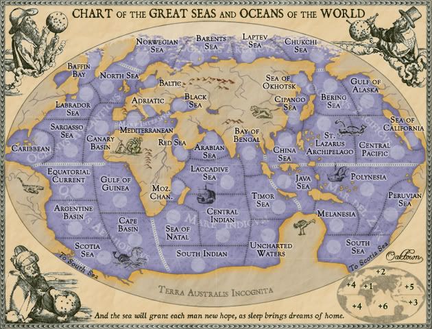
Ruben Cassar wrote:Change the text to Mare Internvm to be in line with the other oceans and seas. Wonderful Latin. ;)

Done.

yeti_c wrote:That territory just wraps round on to the other side of the map... hence the singular territory border on the 1 side. Having said that though - that border looks different to all the others!!

South America border has been fixed on the main map... seems I had both kinds of borders there, territory and region.

ZeakCytho wrote:Some of the rivers look pixely/jagged compared to other things on land (animals, mountains, etc.). I suggested a while ago that you reduce the opacity on the layers for land-stuff (animals, mountains, rivers, etc.) - not sure if you missed that or just disagree.

They do. The manner in which I chose to draw the rivers (layer mask so you're actually seeing through the land to the water color behind) doesn't make for easy tweaking of the opacity, so I need to come up with a solution or just redraw them. It was a mistake and I may end up redrawing them entirely.

I lightened the animals with the last update and I think they're better.

ZeakCytho wrote:There's some weirdness in the minimap by South America/Antarctica - they look like they're connecting, almost. I think this is because on the Scotia sea, you have a dotted line between the territory and the "To South Sea." But on the South Sea territory, this line isn't there. Personally, I don't think the line is necessary. It's obvious enough that they're two separate continents.

The line is supposed to reflect the border on the actual map, but I agree that it isn't entirely necessary. For the sake of consistency I'm leaving it, but it has been significantly lightened up.

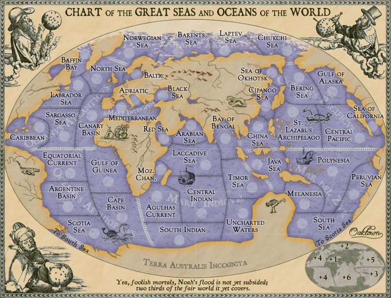
bryguy wrote:1) You have to take a second glance to see that there is a 'to so south sea' and 'to scotia sea'

I can live with it the way it is, unless anybody has another solution - I'm guessing that anybody playing the map won't miss it.

bryguy wrote:2) I like the dotted lines, and i noticed that u put them over the ships to if u needed to, yet u didnt for the thing between scotia sea and cape basin, could u?

Actually all of the borders on a layer behind all of the ships and monsters. Some of the monsters aren't as dense so you can see through them, as you can the whale in the pacific. I think they look better on top of the border - in fact I'd probably rather hollow out the whale than place the border over any others. And I've tried to place the ships and monsters in locations where they only cross long stretches of a single border to avoid any gameplay confusion, but if you see a bad spot let me know.

bryguy wrote:3) this is probably unimportant, but u cant really read the white text saying what the seas are (the white text under the territory names)

At first I didn't want to put the region names on there at all, but I caved. When you think about it the region names aren't necessary - somehow we play Classic without them - so I would rather make them obscured than make the territory titles or borders more difficult to make out.

I would also like to increase the size of the quote a bit, but I don't want to go over the map itself and I don't really think it's worth changing the space it has... thoughts?
User avatar
Captain oaktown
 
Posts: 4451
Joined: Sun Dec 03, 2006 9:24 pm
Location: majorcommand

Re: High Seas, latest pg. 1 & 13 [I, GP, Gr]

Postby bryguy on Fri May 02, 2008 3:33 pm

OK thanks for getting to replying to mine oak :mrgreen: most of it was just noting, and i actually dont think the region names are needed


Also, for the quote, i think its fine as is. But is it supposed to be read as

Ye, foolish mortals
or
Yeah, foolish mortals

i myself think you should reword it to


Ye foolish mortals, Noah's flood has not yet subsided;
two thirds of the fair world it yet covers.


unless its an actual quote... in which case leave it :D
Corporal bryguy
 
Posts: 4381
Joined: Tue Aug 07, 2007 8:50 am
Location: Lost in a Jigsaw

Re: High Seas, latest pg. 1 & 13 [I, GP, Gr]

Postby ZeakCytho on Fri May 02, 2008 3:40 pm

The quote should definitely be "Yea, foolish mortals"

Bryguy, I think a quick glance at the dictionary will show you the difference between Ye, Yea, and Yeah. I'm not even sure ye is a word, actually...
User avatar
Captain ZeakCytho
 
Posts: 1251
Joined: Wed Sep 12, 2007 4:36 pm

Re: High Seas, latest pg. 1 & 13 [I, GP, Gr]

Postby Appalachian on Fri May 02, 2008 11:09 pm

My only question is--- When do we play?

Looks good! So when do we play?
User avatar
Sergeant Appalachian
 
Posts: 58
Joined: Sun Jan 13, 2008 12:42 pm
Location: North Carolina

Re: High Seas, latest pg. 1 & 13 [I, GP, Gr]

Postby oaktown on Sat May 03, 2008 3:13 am

Click image to enlarge.
image


Redrew the rivers throughout... it was nothing that twenty minutes hunched over the tablet couldn't fix.

The text at the bottom is, indeed, a quote - Melville, Moby Dick. It made more sense back when this was supposed to be a 19th century map, but since nobody has caught the reference yet perhaps nobody will call me on it.
User avatar
Captain oaktown
 
Posts: 4451
Joined: Sun Dec 03, 2006 9:24 pm
Location: majorcommand

Re: High Seas, latest pg. 1 & 13 [I, GP, Gr]

Postby bryguy on Sat May 03, 2008 7:56 am

ZeakCytho wrote:The quote should definitely be "Yea, foolish mortals"

Bryguy, I think a quick glance at the dictionary will show you the difference between Ye, Yea, and Yeah. I'm not even sure ye is a word, actually...


Ye is a pirate word, basically meaning you


and ive always pronounced Yea and Yeah the same way
Corporal bryguy
 
Posts: 4381
Joined: Tue Aug 07, 2007 8:50 am
Location: Lost in a Jigsaw

Re: High Seas, latest pg. 1 & 13 [I, GP, Gr]

Postby ZeakCytho on Sat May 03, 2008 12:31 pm

I've thought a lot about that quote. Having not read Moby Dick, I thought it was just a nice thing you made up. But since it is from Moby Dick, and someone on CC other than you is bound to have read Moby Dick and realize that it doesn't fit with the time period, maybe you should take it out. I'm not that much of a fan of it in the first place. However, then you have dead space at the bottom of the map. I can't think of anything to fill that space with, so I'm inclined to say your best option is to find a quote that fits the current map better. But since that's hard, you might be better off just leaving the current quote as is.

A few graphical nitpicks:

Some of the lines of longitude look a bit pixely (see the one by the border between Polynesia and the Java Sea)

The lines of longitude are all perfectly drawn, other than some of the pixelyness. If the premise of this map is that it's from the 16th century, and you are distorting continents because precise longitudes were not known, why draw in exact lines of longitude? So, maybe you should just take out the longitude lines? But the map might look weird with just latitude lines...So maybe make up weird, distorted lines of longitude?

The glow on the dotted lines that show continent borders gets very faint as the line approaches some landmasses, but not others. See how the separator between Oceanus Aethiopicvs and Mare Indicvm gets very faint near South Africa and Antarctica, while the border between Mare Del Zvr and Mare Indicvs stays strong near the Indonesian island in the center? I think the glow should be made thicker at the far ends of each border that suffers from this problem, which is basically all of them.

I think the Mare Internvm font should be a bit larger. I don't think it's a horrible thing if it crosses into the black sea a bit.

I think that's about everything :D

Bryguy - Yeah, I totally wasn't thinking when I said Ye wasn't even a word :oops:
But Yeah (phonetically "yah") and Yea (phonetically "yay") are two separate words.
User avatar
Captain ZeakCytho
 
Posts: 1251
Joined: Wed Sep 12, 2007 4:36 pm

Re: High Seas, latest pg. 1 & 13 [I, GP, Gr]

Postby AndyDufresne on Sat May 03, 2008 2:23 pm

I like the quote, but if you are going to change it perhaps replace it with another that fits the 16th century time period. A few random ones:

"Wherever we wanted to go, the wind blew against us." --Varro

"There are three sorts of people; those who are alive, those who are dead, and those who are at sea." -- Attributed to Anacharsis

"It isn't that life ashore is distasteful to me. But life at sea is better."
-- Sir Francis Drake

I'm not sure any of these would really fit, if you so happen to change the quote. I'd double check them also, if you decide on any.


--Andy
User avatar
Corporal 1st Class AndyDufresne
 
Posts: 24919
Joined: Fri Mar 03, 2006 8:22 pm
Location: A Banana Palm in Zihuatanejo

Re: High Seas, latest pg. 1 & 13 [I, GP, Gr]

Postby oaktown on Sat May 03, 2008 2:41 pm

AndyDufresne wrote:I like the quote, but if you are going to change it perhaps replace it with another that fits the 19th century time period. A few random ones:

that's the problem - the map is no longer 19th century, it's 16th century.

When I get back to it this week I'll try something older... biblical maybe.
Image
User avatar
Captain oaktown
 
Posts: 4451
Joined: Sun Dec 03, 2006 9:24 pm
Location: majorcommand

Re: High Seas, latest pg. 1 & 13 [I, GP, Gr]

Postby AndyDufresne on Sat May 03, 2008 2:57 pm

Perhaps biblical...perhaps look to Ancient Greece -- The Odyssey or some similar accounts of sea mythologies.


--Andy
User avatar
Corporal 1st Class AndyDufresne
 
Posts: 24919
Joined: Fri Mar 03, 2006 8:22 pm
Location: A Banana Palm in Zihuatanejo

Re: High Seas, latest pg. 1 & 13 [I, GP, Gr]

Postby edbeard on Sat May 03, 2008 3:07 pm

here's a couple 17th century quotes

“It is of great use to the sailor to know the length of his line, though he cannot with it fathom all the depths of the ocean.”

John Locke 1632-1704

“The least movement is of importance to all nature. The entire ocean is affected by a pebble.”

Blaise Pascal 1623-1662


I wouldn't recommend this one but since he's one of the inspirations, here's Magellan!

"The Church says that the earth is flat, but I know that it is round, for I have seen the shadow on the moon, and I have more faith in a shadow than in the Church."
User avatar
Lieutenant edbeard
 
Posts: 2501
Joined: Thu Mar 29, 2007 12:41 am

Re: High Seas, latest pg. 1 & 13 [I, GP, Gr]

Postby ZeakCytho on Sat May 03, 2008 3:14 pm

I did a brief search on ocean and sea quotes - here are some that are closer to the time period you have:

Blaise Pascal wrote:The least movement is of importance to all nature. The entire ocean is affected by a pebble.


Horace wrote:They change their climate, not their soul, who rush across the sea.


Shakespeare wrote:Nimble thought can jump both sea and land.

Could be a good, subtle reference to a strategically played game

Pubilius Cyrus wrote:Anyone can steer the ship when the sea is calm.


None are really great, but if you like one better than the current one, go with it.
User avatar
Captain ZeakCytho
 
Posts: 1251
Joined: Wed Sep 12, 2007 4:36 pm

Re: High Seas, latest pg. 1 & 13 [I, GP, Gr]

Postby edbeard on Sat May 03, 2008 3:33 pm

I like the pebble one we both put up.

small moves can make a big difference in the outcome of games


But, I like the current quote. Even though the time period doesn't quite match
User avatar
Lieutenant edbeard
 
Posts: 2501
Joined: Thu Mar 29, 2007 12:41 am

Re: High Seas, latest pg. 1 & 13 [I, GP, Gr]

Postby Incandenza on Sun May 04, 2008 5:00 am

How about this old chestnut from The Tempest? It fits the time period, certainly.

Full fathom five thy father lies;
Of his bones are coral made;
Those are pearls that were his eyes:
Nothing of him that doth fade
But doth suffer a sea-change

There may be better sea-ish line in the play. There might also be a top-notch line in the various ginomorous tomes of The Baroque Cycle, which is slightly off the time period (late 17th-early 18th centuries) but is certain to have some first-rate quotes about seafaring.

Personally, tho, I prefer the original quote, regardless of temporal synchronicity.
THOTA: dingdingdingdingdingdingBOOM

Te Occidere Possunt Sed Te Edere Non Possunt Nefas Est
User avatar
Colonel Incandenza
 
Posts: 4949
Joined: Thu Oct 19, 2006 5:34 pm
Location: Playing Eschaton with a bucket of old tennis balls

Re: High Seas, latest pg. 1 & 13 [I, GP, Gr]

Postby ZeakCytho on Sun May 04, 2008 11:56 am

Incandenza wrote:There might also be a top-notch line in the various ginomorous tomes of The Baroque Cycle, which is slightly off the time period (late 17th-early 18th centuries) but is certain to have some first-rate quotes about seafaring.


I'm reading those books now :D
I'll tell you guys if I come across anything good, though I'm already through half of the second book, so I won't be quoting anything from what I've already read.
User avatar
Captain ZeakCytho
 
Posts: 1251
Joined: Wed Sep 12, 2007 4:36 pm

Re: High Seas, latest pg. 1 & 13 [I, GP, Gr]

Postby iancanton on Thu May 08, 2008 1:55 am

islands in polynesia: now that's revolutionary! the slightly less realistic look of the pacific islands is in keeping with maps of the period. good thinking.

having changed great seas to mare internvm, there remains one anomalous sea continent name, which is mar del zvr. this is a spanish name meaning sea of the south, while all of the others are latin. i'm not a latin scholar and therefore not totally confident that this translates to mare australis. an alternative is to keep mar del zvr (which i presume is a medieval spelling of svr) and alter oceanvs atlanticvs to mar del norte (sea of the north).

Moctezuma had covertly sent agents to inspect the ships of Cortés's predecessor Grijalva, when they put in along the empire's northern coast (at those latitudes, Atlantic is to the north as the Pacific is to the south, as is confirmed by the Spanish words then used for those oceans, "mar del norte" and "mar del sur").

http://www.mexicolore.co.uk/index.php?o ... b=ans&id=4

agulhas current appears to be an anachronism. although ships' captains knew about slow progress in the area when en route to india, the current wasn't studied till 1777, by james rennell. cape agulhas itself was known at the time as cape lagullas in english. the only alternative name for this territory that i can find is the now-obsolete sea of natal, so-called because vasco da gama reached the coastal area on xmas day 1497.

http://www.soc.soton.ac.uk/JRD/history/rennell.php

the blue and yellow colours are blending really nicely.

ian. :)
User avatar
Colonel iancanton
Foundry Foreman
Foundry Foreman
 
Posts: 2424
Joined: Fri Jun 01, 2007 5:40 am
Location: europe

Re: High Seas, latest pg. 1 & 13 [I, GP, Gr]

Postby AndyDufresne on Thu May 08, 2008 11:40 am

              Final Forge

---The High Seas Map has reached the ‘Final Forge’ Stage. I've revived this thread from the pits of the Foundry Furnace (okay, maybe not) and have examined the contents. Nearly every major concern has been addressed. If there are any other current concerns, please make your voice heard. If after a reasonable amount of time there has not been any objection or protest, the map will be deemed finished with the 'Foundry Brand' of approval and will be submitted for live play. As long as there is still discussion or posts that have yet to be commented on, the map will remain in Final Forge until said discussion has reached the conclusion that the map has reached its final and polished version.

Post questions and concerns if any.

              Image

--Andy
User avatar
Corporal 1st Class AndyDufresne
 
Posts: 24919
Joined: Fri Mar 03, 2006 8:22 pm
Location: A Banana Palm in Zihuatanejo

Re: High Seas, latest pg. 1 & 13 [I, GP, Gr]

Postby t-o-m on Thu May 08, 2008 11:54 am

good one oak,
nearly there :D =D> =D>
User avatar
Major t-o-m
 
Posts: 2917
Joined: Sat Mar 22, 2008 2:22 pm

Re: High Seas, latest pg. 1 & 13 [I, GP, Gr]

Postby DiM on Thu May 08, 2008 12:09 pm

congrats mate
“In the beginning God said, the four-dimensional divergence of an antisymmetric, second rank tensor equals zero, and there was light, and it was good. And on the seventh day he rested.”- Michio Kaku
User avatar
Major DiM
 
Posts: 10415
Joined: Wed Feb 14, 2007 6:20 pm
Location: making maps for scooby snacks

Re: High Seas, latest pg. 1 & 13 [I, GP, Gr]

Postby yeti_c on Thu May 08, 2008 2:58 pm

Nice work Oaky.

C.
Image
Highest score : 2297
User avatar
Lieutenant yeti_c
 
Posts: 9624
Joined: Thu Jan 04, 2007 9:02 am

Re: High Seas, latest pg. 1 & 13 [I, GP, Gr]

Postby rgbubba on Thu May 08, 2008 3:09 pm

I really like this map. I can't wait to play this one! Congrads!
"ENJOY THE GAME"
Image
User avatar
Private rgbubba
 
Posts: 282
Joined: Sun Oct 22, 2006 2:04 pm
Location: USA

Re: High Seas, latest pg. 1 & 13 [I, GP, Gr]

Postby oaktown on Fri May 09, 2008 12:32 am

iancanton wrote:agulhas current appears to be an anachronism. although ships' captains knew about slow progress in the area when en route to india, the current wasn't studied till 1777, by james rennell. cape agulhas itself was known at the time as cape lagullas in english. the only alternative name for this territory that i can find is the now-obsolete sea of natal, so-called because vasco da gama reached the coastal area on xmas day 1497.

Yes, there are a number of anachronisms in this map... I like the natal switch, and I'm sure there are many other. Anything that's a "basin" doesn't reflect the time as well. Again, this map began as a 19th century map, and in the gradual conversion back to 16th century graphics many of the 19th century territory names just went along for the ride.

As for Mar del Zur, you see that used alongside the latin names of other oceans on maps from the period. It may not share the same origin as the latin names, but that's a problem the 16th century mapmakers should have dealt with... too bad they had no access to a Foundry of amateur cartographers!

I'm still struggling to find a quote that is pre-16th century. I've got a nice columbus quote, which you all may have heard captain ramius utter in Hunt for Red October...

"and the sea will grant each man new hope, as sleep brings dreams of home."

It fits nicely in a single line across the bottom of the map as well.

Somebody was unhappy with how perfect the longitude and latitude lines look, but that was the one thing old cartographers could get right... not necessarily in the right place, but they could draw them on straight! :)

Update coming in a day or two... possibly even with army coordinates.
User avatar
Captain oaktown
 
Posts: 4451
Joined: Sun Dec 03, 2006 9:24 pm
Location: majorcommand

Re: High Seas, latest pg. 1 & 13 [I, GP, Gr]

Postby oaktown on Fri May 09, 2008 7:45 pm

Click image to enlarge.
image

Image

Here are large and small... made the name change to what is now the Sea of Natal region and replaced the Melville with the Columbus. Also made a change to the color of the inset map and took off some of the grunge - it's still not quite where I want it to be, but at least now it looks like it belongs with the other elements on the map.

This weekend - I center coordinates! My favorite!
User avatar
Captain oaktown
 
Posts: 4451
Joined: Sun Dec 03, 2006 9:24 pm
Location: majorcommand

Re: High Seas, latest pg. 1 & 13 [I, GP, Gr]

Postby AndyDufresne on Fri May 09, 2008 8:58 pm

Good choice on the quote. As for the minimap, I wouldn't mind seeing the landmasses roughly the same darkness as that of the images in the other corners. That might balance everything...or it may just look bad. :)


--Andy
User avatar
Corporal 1st Class AndyDufresne
 
Posts: 24919
Joined: Fri Mar 03, 2006 8:22 pm
Location: A Banana Palm in Zihuatanejo

Re: High Seas, latest pg. 1 & 13 [I, GP, Gr]

Postby bryguy on Sat May 10, 2008 8:46 am

I have a question

why do the south and scotia sea connect, but not baffin bay and chukchi sea?
Corporal bryguy
 
Posts: 4381
Joined: Tue Aug 07, 2007 8:50 am
Location: Lost in a Jigsaw

PreviousNext

Return to The Atlas

Who is online

Users browsing this forum: No registered users