Conquer Club

Finally: South America map [Abandoned]

Have an idea for a map? Discuss ideas and concepts here.

Moderator: Cartographers

Forum rules
Please read the Community Guidelines before posting.

Finally: South America map [Abandoned]

Postby Marvaddin on Sun Oct 29, 2006 6:47 pm

Ok, dont kill me yet, Im not the best one in then artistic part, but Im not this bad too... :wink: The main goal of this first release is discuss playability... :)

Image
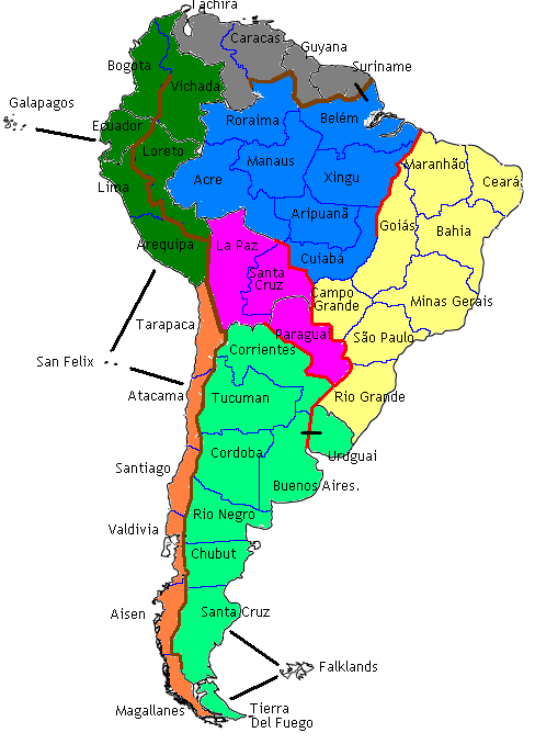
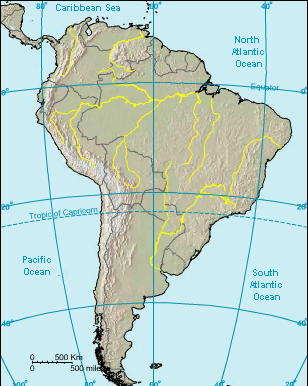
Well, I know... terrible colours, no background, the names are bad positioned, and the font sucks too. In fact, I only put the names to make the discussion easier. The brown and red borders are unpassable. Brown are mountains, Andes and Guyanas Highlands, and red are rivers (they would be blue, but I was using blue for borders, and I was too lazy).

Im thinking about continents names, and I accept suggestions. For now, I considering:
Blue: Brazilian Amazon, or Amazon Basin
Yellow: Eastern Brazil, or Brazilian Coast, or Brazilian Highlands / Shield...
Gray: Guyanas, or Guyanas Highlands... hmm, maybe Venezuela, but I dislike it
Drak green: Northern Andes... I think there is an economical group with these countries, but it would be strange.
Pink: El Chaco
Light green: Argentina, or La Plata
Orange: Chile, for sure :)
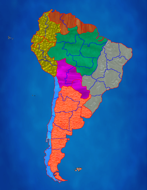
You can see a useful map here:
http://i44.photobucket.com/albums/f44/M ... amera3.gif

Well, I dont need someone:
To tell me I spelled Uruguay and Paraguay wrong (in English), thats the Portuguese form, but because I forgot it.
To tell me there are 2 territories with same name, lol. I will correct that.

I would like some good opinions about this:
- Currently 46 countries, if I didnt miscount. I can remove one, the logical one is San Felix, its there just to make Chile a bit less linear, and add another border. But I would prefer another choice... or maybe it will continue with 46, or add 2 more, etc... ideas?
- Andes create a great linear area to its west... we can create some passages... maybe some one way routes... I was thinking about one from Corrientes to Tarapaca. Well, or maybe we can create a new thing... I was thinking about a paratroopers battalion that can attack positons 2 countries away... Like, if its in La Paz, for example, it can attack any position it could reach with 2 moves, so possible targets include Vichada, Roraima, Rio Grande... It would be a great advantage... maybe a -1 bonus?
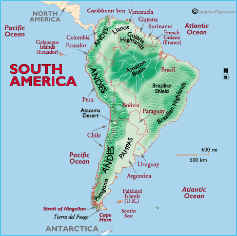
- The mountains and the river in Brazil are a bit accurate, you can check here:
http://i44.photobucket.com/albums/f44/M ... amera3.png
But, the rivers around Paraguay are not... I even gave a piece of Argentina lands to Paraguay... Maybe I should maintain that river to the North, but remove te one to the South... if I do this, the "continent" will have 3 countries and 2 borders... but we can still give it a bonus of 2, because La Paz will possibly to be a very important country to strategy...
- Any other playability things...
User avatar
Major Marvaddin
 
Posts: 2545
Joined: Thu Feb 09, 2006 5:06 pm
Location: Belo Horizonte, Brazil

Postby happysadfun on Sun Oct 29, 2006 6:50 pm

Down south it's a little linear.
ImageChildren, this is what happens to hockey players, druggies, and Hillary Clinton.

Rope. Tree. Hillary. Some assembly required.
User avatar
Cadet happysadfun
 
Posts: 1251
Joined: Mon Jul 10, 2006 9:06 pm
Location: Haundin at DotSco, Being Sad that Mark Green Lost in Suburban Wisconsin

Postby ttocs on Sun Oct 29, 2006 7:03 pm

It's very interesting, but it almost seems like there is something wrong with the map in ters of playability... mabye add a few borders and territories.
User avatar
Private 1st Class ttocs
 
Posts: 240
Joined: Thu Jul 27, 2006 9:38 am
Location: colorado, US (mountian time zone)

Postby strike wolf on Sun Oct 29, 2006 7:18 pm

I know it's just the rough draft but it definitely needs more borders. in some areas and possibly less in others. Also the blue borders make it look like there are rivers blocking access to the territory.
User avatar
Cadet strike wolf
 
Posts: 8343
Joined: Fri May 19, 2006 11:03 pm
Location: Sandy Springs, GA (just north of Atlanta)

Postby cowshrptrn on Sun Oct 29, 2006 7:21 pm

i tihnk something similar to the port concept on the phillipenes map can help to make the south less linear.
Image
User avatar
Private cowshrptrn
 
Posts: 838
Joined: Thu Aug 17, 2006 1:15 pm
Location: wouldn't YOU like to know....

Postby reverend_kyle on Sun Oct 29, 2006 7:42 pm

I cant even tell whats a mountain... and it looks horrible.
DANCING MUSTARD FOR POOP IN '08!
User avatar
Sergeant reverend_kyle
 
Posts: 9250
Joined: Tue Mar 21, 2006 4:08 pm
Location: 1000 post club

Re: Finally: South America map

Postby cowshrptrn on Sun Oct 29, 2006 7:56 pm

reverend_kyle wrote:I cant even tell whats a mountain... and it looks horrible.


Marvaddin wrote:Ok, dont kill me yet, Im not the best one in then artistic part, but Im not this bad too... :wink: The main goal of this first release is discuss playability... :)


its not suposed to look like mountains; its supposed to look like a rough sketch.
Image
User avatar
Private cowshrptrn
 
Posts: 838
Joined: Thu Aug 17, 2006 1:15 pm
Location: wouldn't YOU like to know....

Postby DublinDoogey on Sun Oct 29, 2006 7:57 pm

Hey, looking good for a first draft, just as a note, if you want, when it gets to the final version, i can do the graphics if you'd like, just get it there, then tell me how you'd want them.
User avatar
Private DublinDoogey
 
Posts: 329
Joined: Tue Feb 28, 2006 7:03 pm
Location: Wisconsin

Postby AndyDufresne on Sun Oct 29, 2006 10:33 pm

The layout right now currently has the old 'Ladder Problem'...where you can easily climb up from bottom, increasing your territories without reall increasing borders...I'd consider looking for perhaps a different southern layout of countries, or perhaps something similar to the port system...

But the 'port' idea shouldn't be implemented to fix everything. Its a good idea, but not for every map I think. (I.E. works well with Islands and such, perhaps not a continental map)


--Andy
User avatar
Corporal 1st Class AndyDufresne
 
Posts: 24919
Joined: Fri Mar 03, 2006 8:22 pm
Location: A Banana Palm in Zihuatanejo

Postby gavin_sidhu on Mon Oct 30, 2006 2:34 am

lol at map looks.

I like how the "Australia" of this map is in the centre and the big continents around it. Maybe get add borders from paraguai to yellow and argentina.

Any ideas for continent bonuses yet?
Highest Score: 1843 Ranking (Australians): 3
User avatar
Lieutenant gavin_sidhu
 
Posts: 1428
Joined: Mon May 22, 2006 6:16 am
Location: Brisbane, Australia

Re: Finally: South America map

Postby reverend_kyle on Mon Oct 30, 2006 2:42 am

cowshrptrn wrote:
reverend_kyle wrote:I cant even tell whats a mountain... and it looks horrible.


Marvaddin wrote:Ok, dont kill me yet, Im not the best one in then artistic part, but Im not this bad too... :wink: The main goal of this first release is discuss playability... :)


its not suposed to look like mountains; its supposed to look like a rough sketch.


He has mts on there its hard to tell where the barriers are.. I disagree about the latter effect as the ones down south are huge anyways... and the smaller ones dont allow you to do that.
DANCING MUSTARD FOR POOP IN '08!
User avatar
Sergeant reverend_kyle
 
Posts: 9250
Joined: Tue Mar 21, 2006 4:08 pm
Location: 1000 post club

Postby joeyjordison on Mon Oct 30, 2006 6:58 am

i agree that down south u hav a bit of a ladder problem but then again
there are plenty of small continents on the map so it shouldn't be a big problem. also i like how none of the continents have more than 3 borders (i think :S) so it will make an interesting map to play on. finally one thing i think is important is to have a gd killing ground and i think blue does that well
User avatar
Major joeyjordison
 
Posts: 1170
Joined: Wed Apr 19, 2006 9:10 am

Postby Pedronicus on Mon Oct 30, 2006 8:46 am

Instead of areas - can we have some propers countries?

Make this map useful to people marv so we can further our knowledge of South American geography- Where The f*ck is Bolivia?

Theres a big river in S America. Add that.
Image
Highest position 7th. Highest points 3311 All of my graffiti can be found here
Major Pedronicus
 
Posts: 2080
Joined: Tue Jan 24, 2006 2:42 pm
Location: Busy not shitting you....

Postby Marvaddin on Mon Oct 30, 2006 9:27 am

The main question, about the South Area being linear... Well, at Argentina side, its a bit, only in Rio Negro, Chubut, Santa Cruz area. Maybe we can correct that with some more routes from the Falklands... How about if its connected to Tierra del Fuego, Chubut and Buenos Aires? About Chile, there is no way to correct that. As I said, the whole region west to Andes is linear... and Im looking for alternatives: maybe some routes, or one-way routes, or paratroopers battalions like I mentioned (a feature that doesnt exist yet, and makes possible not only attack over the unpassable, but attack countries that are at 2 steps). Imagine it, for example, in Arequipa... But Im not really considering the naval (or aerial) bases in this map yet :)

DublinDoogey wrote:Hey, looking good for a first draft, just as a note, if you want, when it gets to the final version, i can do the graphics if you'd like, just get it there, then tell me how you'd want them.

Thanks friend :) I will try it by myself, but of course your help is always welcome.

AndyDufresne wrote:The layout right now currently has the old 'Ladder Problem'...where you can easily climb up from bottom, increasing your territories without reall increasing borders...I'd consider looking for perhaps a different southern layout of countries, or perhaps something similar to the port system...

I dont think so. Its possible, but please note how many countries in those continents: Chile 7, and Argentina / Uruguay 10... I wouldnt bet in those areas, specially Argentina... Chile is possible, but so we need an option to correct the linearity to west of Andes mountains, and its good.

gavin_sidhu wrote:I like how the "Australia" of this map is in the centre and the big continents around it. Maybe get add borders from paraguai to yellow and argentina.

Any ideas for continent bonuses yet?

Well, its one of my great questions... borders in that central area... Im considering your suggestion... Bonuses, I didnt think about it yet, but its not very difficult to me, you know :wink:

joeyjordison wrote:also i like how none of the continents have more than 3 borders (i think :S) so it will make an interesting map to play on.

I was thinking about increase numbers of borders... but now you mentioned it, maybe I shouldnt... Opinions about this?? And for now, Argentina and Brazilian Amazon have 4... but to Argentina is easy to reduce to 3, and this, plus the general position, is what makes Brazilian Amazon the fighting ground you mentioned :)

Pedronicus wrote:Make this map useful to people marv so we can further our knowledge of South American geography- Where The f*ck is Bolivia?

Theres a big river in S America. Add that.

Haha, Bolivia is La Paz + Santa Cruz. And many countries are splitted... like Peru: Lima + Arequipa + Loreto. I dont know if there is a good way to make those countries more visible. maybe as subcontinent?? And Brazil as a supercontinent??
About Amazon river, I would like to use it, but its not very useful as border, because it crosses the Brazilian Amazon area... its not between regions... maybe an internal border? Maybe it can have strategic value... although I think its difficult, I will think about it.
Image
User avatar
Major Marvaddin
 
Posts: 2545
Joined: Thu Feb 09, 2006 5:06 pm
Location: Belo Horizonte, Brazil

Postby onbekende on Mon Oct 30, 2006 3:47 pm

You will get my full and short review when I have some time
Emperor of the Benelux
Founder of the Commonwealth of Planets
Founder and CEO of JF
User avatar
Captain onbekende
 
Posts: 1530
Joined: Fri Apr 14, 2006 10:19 am
Location: Belgium

Postby happysadfun on Mon Oct 30, 2006 5:13 pm

Arequipa=the obviously more cultural and shorter named Cuzco.

Dark green better be worth a lot because you can't conquer across. And arequipa/cusco can't be gotten unless you go all the way down to Santa Cruz and Magallanes and then go all the way up again.
ImageChildren, this is what happens to hockey players, druggies, and Hillary Clinton.

Rope. Tree. Hillary. Some assembly required.
User avatar
Cadet happysadfun
 
Posts: 1251
Joined: Mon Jul 10, 2006 9:06 pm
Location: Haundin at DotSco, Being Sad that Mark Green Lost in Suburban Wisconsin

Postby PaperPlunger on Mon Oct 30, 2006 5:18 pm

i've always been so awed at the fact that you make all your maps in paint. The amount of effort you must put into them is crazy
Image
User avatar
Private PaperPlunger
 
Posts: 657
Joined: Sun Mar 05, 2006 3:33 pm
Location: Maine!

Postby Marvaddin on Mon Oct 30, 2006 10:22 pm

happysadfun wrote:Arequipa=the obviously more cultural and shorter named Cuzco.

Dark green better be worth a lot because you can't conquer across. And arequipa/cusco can't be gotten unless you go all the way down to Santa Cruz and Magallanes and then go all the way up again.

Cuzco... I will check its accuracy. Green will not worth that much, since all territories are still connected (Bogota can attack Vichada). About the isolated postion of Arequipa and other areas to west of Andes, I said already Im looking for a solution, and Im open to suggestions, but concrete ones, not only mentioning the problem, please.

Im throwing ideas all the thread, of course new ones are welcome, but friends, please give me feedback about what we talked already.
Image
User avatar
Major Marvaddin
 
Posts: 2545
Joined: Thu Feb 09, 2006 5:06 pm
Location: Belo Horizonte, Brazil

Postby Pedronicus on Tue Oct 31, 2006 1:19 pm

Why not have bolivia as east and west bolivia (at least people would know where it is if someone in the street asked them - I often get stopped in London by tourists asking 'Where is Bolivia?")

and further to my idea of the Amazon River - How about adding the larger part of it to the map and then making it full of Piranahs and if you cross it - you lose 20% of your river crossing armies to the piranahs? :twisted:

It would give the map a more South American feel.

Add Easter Island
Image
Highest position 7th. Highest points 3311 All of my graffiti can be found here
Major Pedronicus
 
Posts: 2080
Joined: Tue Jan 24, 2006 2:42 pm
Location: Busy not shitting you....

Postby Marvaddin on Thu Nov 02, 2006 3:32 pm

Easter Island... I can think about it, although I dont want make Chile a big continent... maybe I can replace another territory.

Im not wanting to call this a new update... Im just testing some textures, and a sea, and would like to know what do you think. Same textures to all areas, or just one for all? What do you like the most? What I should change?

Image
Image
User avatar
Major Marvaddin
 
Posts: 2545
Joined: Thu Feb 09, 2006 5:06 pm
Location: Belo Horizonte, Brazil

Postby Backglass on Thu Nov 02, 2006 3:34 pm

Ya gotta have Easter Island. Chilean.
Image
The Pro-Tip®, SkyDaddy® and Image are registered trademarks of Backglass Heavy Industries.
User avatar
Corporal 1st Class Backglass
 
Posts: 2212
Joined: Wed Aug 23, 2006 5:48 pm
Location: New York

Postby Hoff on Thu Nov 02, 2006 4:44 pm

looks like with work that it will make a good map. keep it up marv
User avatar
Sergeant Hoff
 
Posts: 861
Joined: Thu Mar 16, 2006 1:46 am
Location: Philadelphia, PA

Postby Dlakavi on Thu Nov 02, 2006 5:04 pm

AAgh! My eyes!!!
What colours are these?
Anyway, with some good mountain placing map could be very playable (or at least i think sice im partialy blind at the moment from these textures)
User avatar
Lieutenant Dlakavi
 
Posts: 238
Joined: Wed Aug 23, 2006 7:45 am

Postby happysadfun on Fri Nov 03, 2006 6:16 pm

Backglass wrote:Ya gotta have Easter Island. Chilean.
ImageChildren, this is what happens to hockey players, druggies, and Hillary Clinton.

Rope. Tree. Hillary. Some assembly required.
User avatar
Cadet happysadfun
 
Posts: 1251
Joined: Mon Jul 10, 2006 9:06 pm
Location: Haundin at DotSco, Being Sad that Mark Green Lost in Suburban Wisconsin

Postby Hoff on Fri Nov 03, 2006 6:20 pm

yeah i agree that the colors and textures are awful. But I dont think thats a main issure at this stage.
User avatar
Sergeant Hoff
 
Posts: 861
Joined: Thu Mar 16, 2006 1:46 am
Location: Philadelphia, PA

Next

Return to Melting Pot: Map Ideas

Who is online

Users browsing this forum: No registered users