Conquer Club

High Seas Map [Abandoned - new project thread]

Have an idea for a map? Discuss ideas and concepts here.

Moderator: Cartographers

Forum rules
Please read the Community Guidelines before posting.

High Seas Map [Abandoned - new project thread]

Postby ViscountGort on Wed Jan 31, 2007 12:57 pm

UPDATE:
Version 2.2:


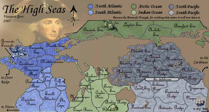
Image


There's no longer any need to vote in the poll as the layout of the map has now been set as it is, with the split down the Americas (i.e. neither poll option).
[Results of the poll for the records...
Where should the map be divided?
Down the midatlantic 39% [ 26 ]
Down the middle of Africa 60% [ 40 ]
Total Votes : 66 ]

===========================
=====ORIGINAL POST BELOW=======
===========================

I thought it would be interesting to create a map in which the territories are not land areas at all, but rather regions of the oceans.

Below is a draft of the sort of structure I had in mind.

See above for current updated image.
The original can be viewed here.

6 continents, 40 countries. Bonuses still to be decided.

The Midtlantic Ridge and Midpacific Seamounts provide impassable boundaries lying between the E & W Atlantic and the N & S Pacific. These are both real geographical features.

Clearly it still needs considerable work visually, but I wanted to gauge early opinion on whether or not this could become a workable map.

Any comments welcome.

EDIT:: I've just discovered that another map exists in suspended development based on exactly the same idea, which I didn't know while I was producing this map or even when I posted it up here an hour ago. By coincidence some of the territories have the same or similar names.
Last edited by ViscountGort on Wed Feb 07, 2007 11:15 am, edited 7 times in total.
User avatar
Corporal 1st Class ViscountGort
 
Posts: 35
Joined: Mon Jan 22, 2007 7:21 am
Location: University of Durham, England

Postby sully800 on Wed Jan 31, 2007 2:05 pm

I liked the idea before and I still like it now. It seems that you picked a stranged place to divide the map from east and west though.

If you move that division into the vertical africa/europe plane you could avoid dividing most of the sea. I think it might make the midatlantic ridge a bit clearer (or at least make it look better).
User avatar
Major sully800
 
Posts: 4978
Joined: Wed Jun 14, 2006 5:45 pm
Location: Bethlehem, Pennsylvania

Postby Balsiefen on Wed Jan 31, 2007 2:10 pm

Nice map and an idea that will work well
mabye change straits of gebraltar to mediteranian as the straits are a very small aria
also is the border between the chukchi sea and the bearing/othotsk sea impassable? if it is then the arctic is cut off, if it isnt it would still be an idea to make the sea round greenland so it isn't too easy to hold

apart from that once the graphics are sorted out this will make a very good map
User avatar
Sergeant 1st Class Balsiefen
 
Posts: 2299
Joined: Wed Aug 30, 2006 6:15 am
Location: The Ford of the Aldar in the East of the Kingdom of Lindissi

Postby Lone.prophet on Wed Jan 31, 2007 2:19 pm

can u try getting greenwich in the middle?
Image
Captain Lone.prophet
 
Posts: 1467
Joined: Thu Oct 12, 2006 4:37 pm
Location: Your basement Muahaha

Postby bedplay on Wed Jan 31, 2007 2:49 pm

love the idea, I totally agree with the position of the world, since pacific is by far the biggest ocean, the world should be centred around it. some of the borders between the pacific and the indian oceans are very confusing.

tbh, I think each continent, bar the artic ocean have too many borders for the number of countries they have.
"It is fatal to enter any war without the will to win it."
- General Douglas MacArthur
User avatar
Private 1st Class bedplay
 
Posts: 171
Joined: Fri Jan 19, 2007 2:00 pm

Postby Nikita_2006 on Wed Jan 31, 2007 2:56 pm

I like this idea, it is the world "upside down"

But it is a lttle bit strange to see the world in this way.

Let we give it a chance
Private Nikita_2006
 
Posts: 486
Joined: Thu Oct 19, 2006 8:35 am

Postby MarVal on Wed Jan 31, 2007 2:58 pm

Its a nice move.
This map has potentiel! Go for it...

Grtz
Marval
Image highest score: 2157 (Major) / Verd ori'shya beskar'gam
ImageImage
User avatar
Corporal MarVal
 
Posts: 3823
Joined: Sat Nov 11, 2006 4:45 pm
Location: De Veroveraars der Lage Landen

Postby LewisJB3 on Wed Jan 31, 2007 3:18 pm

Since the Atlantic is split up it might be cool to have a bonus if you have both of them... just an idea.
Last edited by LewisJB3 on Wed Jan 31, 2007 4:02 pm, edited 1 time in total.
User avatar
Cook LewisJB3
 
Posts: 195
Joined: Tue Nov 21, 2006 3:21 pm

Postby oaktown on Wed Jan 31, 2007 3:49 pm

i love the idea... i've been thinking about picking up the idea myself, but using a pseudocylindrical projection, centered and enlarging the mediteranean area so as to make the med. a "continent" made up of the adriatic, aegean, marmara, straights of gibraltar, etc. But I'm really glad somebody else is working on it, as my plate is full.

I also have trouble with the division - makes more sense to split the map over land, as the land map of the world is split over water. I was thinking I'd split the map over the americas, with a panama canal connection, a south sea connection, and an arctic connection.

Creating an uncrossable border in the middle of an ocean is weird... is the idea that these are armies fighting on the ocean floor? Because can't ships still cross a mid-ocean ridge?

Finally, the earth's surface is like 70% water, right? This looks like you started with a standard northern-hemisphere-centric map of the world, which doesn't fairly represent most of the earth's oceans. The map should look something more like the one below...

Image
Image
User avatar
Captain oaktown
 
Posts: 4451
Joined: Sun Dec 03, 2006 9:24 pm
Location: majorcommand

Postby Guiscard on Wed Jan 31, 2007 4:40 pm

Looks like a brilliant idea, have been thinking about naval stuff myself. Yeh I agree with the others that the map you;ve used seems a little off...

Oaktown has a good point about impassable borders, however, so perhaps look into obstacles which would actually inhibit ships? Reefs? Stroms? High winds? Even strong currents I suppost...
qwert wrote:Can i ask you something?What is porpose for you to open these Political topic in ConquerClub? Why you mix politic with Risk? Why you not open topic like HOT AND SEXY,or something like that.
User avatar
Private 1st Class Guiscard
 
Posts: 4103
Joined: Fri Dec 08, 2006 7:27 pm
Location: In the bar... With my head on the bar

Postby sully800 on Wed Jan 31, 2007 6:01 pm

sully800 wrote:I liked the idea before and I still like it now. It seems that you picked a stranged place to divide the map from east and west though.

If you move that division into the vertical africa/europe plane you could avoid dividing most of the sea. I think it might make the midatlantic ridge a bit clearer (or at least make it look better).


I just wanted to clarify my idea from before. Obviously I did a quick hack job with the graphics, but you get the idea.

Image

In this version, it would look a lot better if you connected the arctic sea in the NE of north america to the atlantic. That would also eliminate the problem of having the arctic with only one border. Then the only other change would be drawing the connection from red to green below Africa like the Alaska-Kamchatka off the map connection in Classic.

Also, all of the choke points (gibraltor, bering strait, red sea, panama) need to be widened to the point of being unrealistic, because I think they are meant to be connections but they're too narrow to tell.
Last edited by sully800 on Wed Jan 31, 2007 10:32 pm, edited 1 time in total.
User avatar
Major sully800
 
Posts: 4978
Joined: Wed Jun 14, 2006 5:45 pm
Location: Bethlehem, Pennsylvania

Postby bedplay on Wed Jan 31, 2007 6:28 pm

sully800 wrote:
sully800 wrote:I liked the idea before and I still like it now. It seems that you picked a stranged place to divide the map from east and west though.

If you move that division into the vertical africa/europe plane you could avoid dividing most of the sea. I think it might make the midatlantic ridge a bit clearer (or at least make it look better).


I just wanted to clarify my idea from before. Obviously I did a quick hack job with the graphics, but you get the idea.

Image

In this version, it would look a lot better if you connected the arctic see in the NE of north america to the atlantic. That would also eliminate the problem of having the arctic with only one border. Then the only other change would be drawing the connection from red to green below Africa like the Alaska-Kamchatka off the map connection in Classic.

Also, all of the choke points (gibraltor, bering strait, red sea, panama) need to be widened to the point of being unrealistic, because I think they are meant to be connections but they're too narrow to tell.


I really do prefer the 1st image, with the countries still intact...

and can the choke points not be represented by arrows? or canal type things (bridges, with two black lines either side, but instead of brown blue)
"It is fatal to enter any war without the will to win it."
- General Douglas MacArthur
User avatar
Private 1st Class bedplay
 
Posts: 171
Joined: Fri Jan 19, 2007 2:00 pm

Postby ViscountGort on Wed Jan 31, 2007 7:28 pm

thanks for the feedback everyone. many of the points raised were things i'd also wondered about while producing the map, which was nicew to see.

the main one is clearly where to divide the map. i think there's a good case for splitting the map as sully suggested above, but this map may be hard to get used to visually. tomorrow i'll create a proper version with the divide at this point, and will put up a poll so people can decide.

regarding the seamounts and ridge as impassable boundaries, you're quite right oaktown - these would pose no obstable to ships in reality. guiscard's idea of storms and high winds are a great suggestion - probably much more appropriate. Would appreciate hearing everyone else's thoughts on this matter though...

finally oaktown i think your suggestion about the robinson projection is interesting, especially the point about it emphasising the oceans better. my concern is that while the med & other central areas are slightly increased in size, which is good, the extremely curved edges could become harder to work with.

keep the comments coming everyone, it's all very much appreciated. i'll be back tomorrow with the poll. :D
Last edited by ViscountGort on Wed Jan 31, 2007 7:29 pm, edited 1 time in total.
User avatar
Corporal 1st Class ViscountGort
 
Posts: 35
Joined: Mon Jan 22, 2007 7:21 am
Location: University of Durham, England

Postby AndyDufresne on Wed Jan 31, 2007 7:29 pm

Link to original idea just for those that want to take a look at it. Take a gander at the thread.


--Andy
User avatar
Corporal 1st Class AndyDufresne
 
Posts: 24919
Joined: Fri Mar 03, 2006 8:22 pm
Location: A Banana Palm in Zihuatanejo

Postby wicked on Wed Jan 31, 2007 7:31 pm

Where are the pirates? and sea monsters? and submarine attack routes? liven it up a bit!
User avatar
Major wicked
 
Posts: 15787
Joined: Thu Jan 26, 2006 1:23 pm

Postby sully800 on Wed Jan 31, 2007 7:54 pm

Here's another thing I don't like about the way you originally split the Atlantic: The West atlantic ends up on the far east of the map, and the East Atlantic sits on the far west side. :?
User avatar
Major sully800
 
Posts: 4978
Joined: Wed Jun 14, 2006 5:45 pm
Location: Bethlehem, Pennsylvania

Postby sully800 on Wed Jan 31, 2007 7:57 pm

bedplay wrote:I really do prefer the 1st image, with the countries still intact...


I know its just a difference of opinion then, but keep in mind that the land masses are not the important feature of this map. If you were creating a map based on land (ie classic) you would divide it where there is a minimum amount of land (middle of the pacific ocean).

Since this map is just the opposite, I think it only makes sense to divide the neutral land territory up, and leave the seas intact since they are the countries. That was my reasoning behind the suggestion anyway.

EDIT: I also want to say I agree with wicked's suggestions about sea monsters, pirates, etc. They would make a nice aesthetic touch but you also don't need to worry too much about looks right away.

I was reading the old Seven Seas thread though and I like their idea of the Bermuda triangle. That would be the PERFECT place to use a recent suggestion of the foundry- have a country that can be attacked but can't attack any where else. That way any armies you have on the bermuda triangle would be essentially lost, and could only act defensively. That is possible with the XML too (all one way borders) and its a feature that no map has so I think it would be an awesome way to make this map a little different than all of the others. :)
User avatar
Major sully800
 
Posts: 4978
Joined: Wed Jun 14, 2006 5:45 pm
Location: Bethlehem, Pennsylvania

Postby gavin_sidhu on Wed Jan 31, 2007 10:04 pm

i like sully's split, makes much more sense.
User avatar
Lieutenant gavin_sidhu
 
Posts: 1428
Joined: Mon May 22, 2006 6:16 am
Location: Brisbane, Australia

Postby ViscountGort on Thu Feb 01, 2007 8:06 am

I've created a preliminary version similar to the mock-up sully did yesterday. What does everyone think? I'm quite undecided at this point, though probably leaning toward the mid-africa split (v1.1).... i'll be interested in the results of the poll.

Once this major issue is sorted we can begin addressing some of the other interesting points raised in the thread so far.
User avatar
Corporal 1st Class ViscountGort
 
Posts: 35
Joined: Mon Jan 22, 2007 7:21 am
Location: University of Durham, England

Postby Guiscard on Thu Feb 01, 2007 8:44 am

sully800 wrote:I was reading the old Seven Seas thread though and I like their idea of the Bermuda triangle. That would be the PERFECT place to use a recent suggestion of the foundry- have a country that can be attacked but can't attack any where else. That way any armies you have on the bermuda triangle would be essentially lost, and could only act defensively. That is possible with the XML too (all one way borders) and its a feature that no map has so I think it would be an awesome way to make this map a little different than all of the others. :)


OOOH! :D I'm keen on that!
qwert wrote:Can i ask you something?What is porpose for you to open these Political topic in ConquerClub? Why you mix politic with Risk? Why you not open topic like HOT AND SEXY,or something like that.
User avatar
Private 1st Class Guiscard
 
Posts: 4103
Joined: Fri Dec 08, 2006 7:27 pm
Location: In the bar... With my head on the bar

Postby oaktown on Thu Feb 01, 2007 5:40 pm

took a look at the old oceans map, and I have to say this one is an improvement... still, both are seriously psychadelic in their design. Seems like this map would be best served by taking full advantage of the nautical theme, and making it look like an old sea chart or pirate map. You know, Spanish galleons, sea monsters, skull and cross bones, crap like that. I'd love to see something that looks like it's etched onto leather and been bleached by years of sun exposure.

Image
Image
User avatar
Captain oaktown
 
Posts: 4451
Joined: Sun Dec 03, 2006 9:24 pm
Location: majorcommand

Postby ViscountGort on Fri Feb 02, 2007 12:54 pm

i love all the suggestions that have been brought up for quirky feautures like the bermuda triangle, and stylistic ones like an old maritime map look.

but i don't really want to start trying to implement these until i know which map layout i'm working with.... i'm really torn between the two. would appreciate hearing some more comments (or just having more votes in the poll) from anyone with an opinion.
User avatar
Corporal 1st Class ViscountGort
 
Posts: 35
Joined: Mon Jan 22, 2007 7:21 am
Location: University of Durham, England

Postby king_kraig on Fri Feb 02, 2007 1:40 pm

Very nice map Gort, id certainly play it. Im a fan of the Africa split version of the map, I think it just makes more sense. With regards to the projection, the map your using looks very similar to the Mercator projection, and is more than likely to be based on that (most maps are). With this projection scale is the same in every direction, around any position (but size is distorted), which is why its the primary projection used in the nautical world, apt for a cc map based on the oceans. However, the projection you use is really a matter of taste, if you want a non-euro centric map, try Gall-Peters, size isnt distorted, but shapes of continents are (Africa suddenly appears as a much largest continent!)

Pirates and sea monsters would be a nice touch, but i think your right to leave that aside for now.

Hope this was in someway helpful.

KK
Cook king_kraig
 
Posts: 1
Joined: Fri Jan 19, 2007 5:43 pm
Location: Leeds

Postby oaktown on Fri Feb 02, 2007 2:42 pm

ViscountGort wrote:but i don't really want to start trying to implement these until i know which map layout i'm working with.... i'm really torn between the two. would appreciate hearing some more comments (or just having more votes in the poll) from anyone with an opinion.


sound thinking. I haven't voted because I'm not a fan of either. I agree that europe to africa is a logical spot to split because ofthe amount of land mass from pole to pole, but it splits the mediteranean in half as well. Seems like the Med. should be a territory, as it's a body of water with far more economic and historical importance than, say, the Beaufort Sea.

I'd vote for a split down the Americas, with three connections off the sides of the map: arctic, south sea, and panama canal. You could take some artistic license and rotate central and south america a bit to make the map break on as much land as possible.

And the wall in the middle of the atlantic still seems like a bad idea - make it fewer, larger territories, and add territories elsewhere - north atlantic, baltic, med, caspian, hudson bay, etc?
Image
User avatar
Captain oaktown
 
Posts: 4451
Joined: Sun Dec 03, 2006 9:24 pm
Location: majorcommand

Postby sully800 on Fri Feb 02, 2007 8:13 pm

oaktown wrote:I'd vote for a split down the Americas, with three connections off the sides of the map: arctic, south sea, and panama canal. You could take some artistic license and rotate central and south america a bit to make the map break on as much land as possible.

And the wall in the middle of the atlantic still seems like a bad idea - make it fewer, larger territories, and add territories elsewhere - north atlantic, baltic, med, caspian, hudson bay, etc?


That's also a decent place for a split. Or you could do it across Asia and Australia like the old Seven Seas map. I like all 3 of those better than splitting the ocean.
User avatar
Major sully800
 
Posts: 4978
Joined: Wed Jun 14, 2006 5:45 pm
Location: Bethlehem, Pennsylvania

Next

Return to Melting Pot: Map Ideas

Who is online

Users browsing this forum: No registered users