Conquer Club

Central America [Quenched]

Care to peruse completed maps? Take a stroll through the Atlas.

Moderator: Cartographers

Forum rules
Please read the Community Guidelines before posting.

Re: Central America V12 Let's Finish It! [D,GP]

Postby lgoasklucyl on Fri Mar 19, 2010 8:42 pm

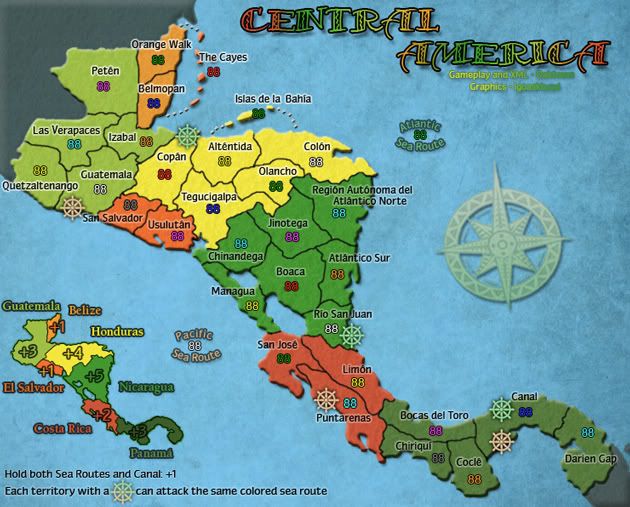
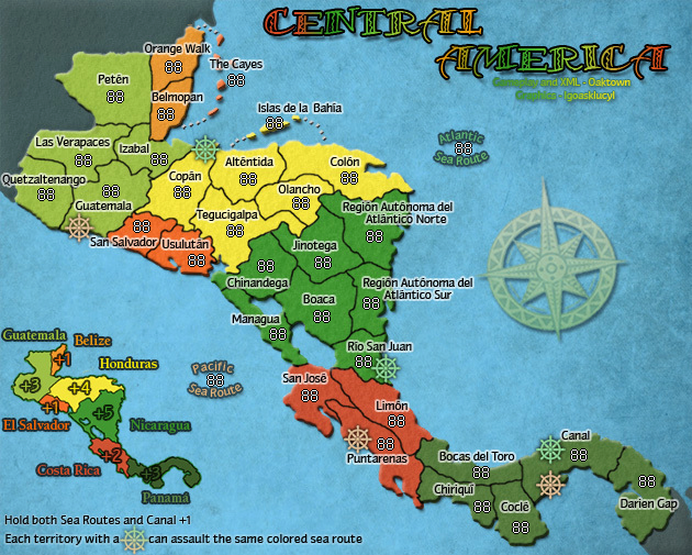
RedBaron0 wrote:The small map is usually the most annoying part, take your time and get it as right as possible to start and we'll help you along the way. :)


It's definitely a lot harder than I had expected. I assumed retaining proportions over a resize would be a pretty simple adjustment, but quite a few things look pretty sloppy.
Image
User avatar
Sergeant 1st Class lgoasklucyl
 
Posts: 526
Joined: Mon Apr 07, 2008 8:49 pm
Location: Somewhere in the 20th century.

Re: Central America V12 Let's Finish It! [D,GP]

Postby natty dread on Fri Mar 19, 2010 8:55 pm

I'm not sure if this will help, but... I've noticed that resizing usually works best when the ratios hit even pixels, eg. 400x400 -> 300x300 = 4:3, meaning 4x4 pixels becomes 3x3 pixels. Then again if you resize 400x400 into 320x320, even though the proportions are the same, in this case 4x4 pixels becomes 3.2x3.2 pixels, and this can cause some distortion, especially at small details, thin lines etc.

My best advice is to figure out a ratio that hits even pixels, while staying withing the guidelines of image size.
Image
User avatar
Sergeant 1st Class natty dread
 
Posts: 12877
Joined: Fri Feb 08, 2008 8:58 pm
Location: just plain fucked

Re: Central America V12 Let's Finish It! [D,GP]

Postby oaktown on Sun Mar 21, 2010 12:29 pm

resizing is a drag, but you shouldn't lose any sleep over it. Since it's not like this is a huge map to begin with I'd suggest going with the max small width of 630 pixels. Here's a simple resizing of your latest jpg... it looks fine to me, but I'm sure a resize of the original psd would look even better.

Image

Let me know how I can help.
Image
User avatar
Captain oaktown
 
Posts: 4451
Joined: Sun Dec 03, 2006 9:24 pm
Location: majorcommand

Re: Central America V13 Small Map! [D,GP]

Postby lgoasklucyl on Sat Apr 03, 2010 5:23 pm

Version 13:
-More pixelation work
-A couple territory name adjustments
-Small map!

Version 13:
Large
Click image to enlarge.
image


Small
Image
Image
User avatar
Sergeant 1st Class lgoasklucyl
 
Posts: 526
Joined: Mon Apr 07, 2008 8:49 pm
Location: Somewhere in the 20th century.

Re: Central America V13 Small Map! [D,GP]

Postby natty dread on Sat Apr 03, 2010 5:59 pm

Looks solid to me! I don't see any problems whatsoever, if I was a mod I'd stamp this right now.
Image
User avatar
Sergeant 1st Class natty dread
 
Posts: 12877
Joined: Fri Feb 08, 2008 8:58 pm
Location: just plain fucked

Re: Central America V13 Small Map! [D,GP]

Postby lgoasklucyl on Sat Apr 03, 2010 6:03 pm

natty_dread wrote:Looks solid to me! I don't see any problems whatsoever, if I was a mod I'd stamp this right now.


Notably, I have to switch Quetz./Guatamela's positions on the large map like they are on the small. I feel like it could promote as to which is connected to the wheel, so I moved them around.
Image
User avatar
Sergeant 1st Class lgoasklucyl
 
Posts: 526
Joined: Mon Apr 07, 2008 8:49 pm
Location: Somewhere in the 20th century.

Re: Central America V13 Small Map! [D,GP]

Postby natty dread on Sat Apr 03, 2010 6:08 pm

Yes, that's probably a good idea.
Image
User avatar
Sergeant 1st Class natty dread
 
Posts: 12877
Joined: Fri Feb 08, 2008 8:58 pm
Location: just plain fucked

Re: Central America V13 Small Map! [D,GP]

Postby jefjef on Sat Apr 03, 2010 6:17 pm

Hi.

Just some thoughts.

This may or may not have been addressed but what jumps out at me is the orange Belize bonus might blend to closely to orange numbers.

Your using 3 shades of green for bonus regions. Colorblindness could be an issue.

You could use a brown and a tan.

GL
This post was made by jefjef who should be on your ignore list.
Image
drunkmonkey wrote:I'm filing a C&A report right now. Its nice because they have a drop-down for "jefjef".
User avatar
Colonel jefjef
 
Posts: 6026
Joined: Mon Feb 23, 2009 8:41 pm
Location: on my ass

Re: Central America V13 Small Map! [D,GP]

Postby oaktown on Sun Apr 04, 2010 3:32 pm

The next time you post an update, if you could please post it without the 88s I'll be able to use it to check coordinates. Thanks.
Image
User avatar
Captain oaktown
 
Posts: 4451
Joined: Sun Dec 03, 2006 9:24 pm
Location: majorcommand

Re: Central America V13.1 Moving Quickly!! [D,GP]

Postby lgoasklucyl on Sun Apr 04, 2010 3:50 pm

Version 13:
-Moved the name int he large version
-Took the 88s out for Oak
-Left one 88 in Belize so we can see that it's readable =)

Version 13:
Large
Click image to enlarge.
image


With the 88 in Belize
Click image to enlarge.
image


Small
Image

I'm pretty sure we have looked through all of the colors with regards to colorblind issues. If anything comes up, we can change it; but I'm pretty sure they were deemed okay.

With regards to the orange- I left an orange 88 up there so we can see it's readable =)

New version up without 88s, let's get this done!
Image
User avatar
Sergeant 1st Class lgoasklucyl
 
Posts: 526
Joined: Mon Apr 07, 2008 8:49 pm
Location: Somewhere in the 20th century.

Re: Central America V13 Small Map! [D,GP]

Postby lgoasklucyl on Sun Apr 04, 2010 3:50 pm

oaktown wrote:The next time you post an update, if you could please post it without the 88s I'll be able to use it to check coordinates. Thanks.


Up :)
Image
User avatar
Sergeant 1st Class lgoasklucyl
 
Posts: 526
Joined: Mon Apr 07, 2008 8:49 pm
Location: Somewhere in the 20th century.

Re: Central America V13.1 Moving Quickly!! [D,GP]

Postby RjBeals on Thu Apr 08, 2010 11:40 am

wow. this map has come a long way since my last visit. Looking good!
Image
User avatar
Private RjBeals
 
Posts: 2506
Joined: Mon Nov 20, 2006 5:17 pm
Location: South Carolina, USA

Re: Central America V13.1 Moving Quickly!! [D,GP]

Postby lgoasklucyl on Thu Apr 08, 2010 2:44 pm

RjBeals wrote:wow. this map has come a long way since my last visit. Looking good!


Thanks :) Hopefully we can get it moving along and finish it up soon!
Image
User avatar
Sergeant 1st Class lgoasklucyl
 
Posts: 526
Joined: Mon Apr 07, 2008 8:49 pm
Location: Somewhere in the 20th century.

Re: Central America V13.1 Moving Quickly!! [D,GP]

Postby porkenbeans on Thu Apr 08, 2010 4:31 pm

I like the look of this map very much.
I would like to see some different options for the water, in the way of textures. 8-)
Image
User avatar
Lieutenant porkenbeans
 
Posts: 2546
Joined: Mon Sep 10, 2007 4:06 pm

Re: Central America V13.1 Moving Quickly!! [D,GP]

Postby oaktown on Fri Apr 09, 2010 3:02 pm

Alright, here's the updated XML with coordinates. My only concern is that I used chipv's XML Wizard to test and tweak the coordinates and it reverted my character entity references to the actual characters... if i remember correctly, CC's engine has always been able to read the straight characters, but BOB had trouble with them. If BOB's problems have been resolved, we're good to go.

Map looking good by the way, Igo! =D>

Code: Select all
<?xml version="1.0" encoding="UTF-8"?>
<map>

    <title>Central America</title>
    <smallwidth>630</smallwidth>
    <smallheight>507</smallheight>
    <largewidth>740</largewidth>
    <largeheight>596</largeheight>
    <filetype>jpg</filetype>

<positions>
   <position>
      <territory>San Salvador</territory>
   </position>
   <position>
      <territory>UsulutĆ”n</territory>
   </position>
</positions>
<continent>
   <name>Guatemala</name>
   <bonus>3</bonus>
   <components>
      <territory>PetĆ©n</territory>
      <territory>Izabal</territory>
      <territory>Las Verapaces</territory>
      <territory>Quetzaltenango</territory>
      <territory>Guatemala</territory>
   </components>
</continent>
<continent>
   <name>Belize</name>
   <bonus>1</bonus>
   <components>
      <territory>Orange Walk</territory>
      <territory>The Cayes</territory>
      <territory>Belmopan</territory>
   </components>
</continent>
<continent>
   <name>Honduras</name>
   <bonus>4</bonus>
   <components>
      <territory>CopĆ”n</territory>
      <territory>AltĆ©ntida</territory>
      <territory>Islas de la BahĆ­a</territory>
      <territory>Tegucigalpa</territory>
      <territory>Olancho</territory>
      <territory>ColĆ³n</territory>
   </components>
</continent>
<continent>
   <name>El Salvador</name>
   <bonus>1</bonus>
   <components>
      <territory>San Salvador</territory>
      <territory>UsulutĆ”n</territory>
   </components>
</continent>
<continent>
   <name>Nicaragua</name>
   <bonus>5</bonus>
   <components>
      <territory>RegiĆ³n AutĆ³noma del AtlĆ”ntico Norte</territory>
      <territory>Jinotega</territory>
      <territory>Chinandega</territory>
      <territory>Managua</territory>
      <territory>Boaca</territory>
      <territory>AtlĆ”ntico Sur</territory>
      <territory>Rio San Juan</territory>
   </components>
</continent>
<continent>
   <name>PanamĆ”</name>
   <bonus>3</bonus>
   <components>
      <territory>Darien Gap</territory>
      <territory>Canal</territory>
      <territory>Bocas del Toro</territory>
      <territory>ChiriquĆ­</territory>
      <territory>CoclĆ©</territory>
   </components>
</continent>
<continent>
   <name>Costa Rica</name>
   <bonus>2</bonus>
   <components>
      <territory>LimĆ³n</territory>
      <territory>Puntarenas</territory>
      <territory>San JosĆ©</territory>
   </components>
</continent>
<continent>
   <name>Shipping Lanes</name>
   <bonus>1</bonus>
   <components>
      <territory>Canal</territory>
      <territory>Pacific Sea Route</territory>
      <territory>Atlantic Sea Route</territory>
   </components>
</continent>
<territory>
   <name>Orange Walk</name>
   <borders>
      <border>The Cayes</border>
      <border>Belmopan</border>
      <border>PetĆ©n</border>
   </borders>
   <coordinates>
      <smallx>153</smallx>
      <smally>82</smally>
      <largex>182</largex>
      <largey>93</largey>
   </coordinates>
</territory>
<territory>
   <name>The Cayes</name>
   <borders>
      <border>Orange Walk</border>
      <border>Belmopan</border>
   </borders>
   <coordinates>
      <smallx>210</smallx>
      <smally>94</smally>
      <largex>257</largex>
      <largey>107</largey>
   </coordinates>
</territory>
<territory>
   <name>Belmopan</name>
   <borders>
      <border>The Cayes</border>
      <border>Orange Walk</border>
      <border>PetĆ©n</border>
      <border>Izabal</border>
   </borders>
   <coordinates>
      <smallx>146</smallx>
      <smally>125</smally>
      <largex>177</largex>
      <largey>143</largey>
   </coordinates>
</territory>
<territory>
   <name>PetĆ©n</name>
   <borders>
      <border>Orange Walk</border>
      <border>Belmopan</border>
      <border>Izabal</border>
      <border>Las Verapaces</border>
   </borders>
   <coordinates>
      <smallx>100</smallx>
      <smally>109</smally>
      <largex>119</largex>
      <largey>122</largey>
   </coordinates>
</territory>
<territory>
   <name>Izabal</name>
   <borders>
      <border>Belmopan</border>
      <border>PetĆ©n</border>
      <border>Las Verapaces</border>
      <border>Guatemala</border>
      <border>CopĆ”n</border>
   </borders>
   <coordinates>
      <smallx>140</smallx>
      <smally>166</smally>
      <largex>168</largex>
      <largey>190</largey>
   </coordinates>
</territory>
<territory>
   <name>Las Verapaces</name>
   <borders>
      <border>Quetzaltenango</border>
      <border>PetĆ©n</border>
      <border>Izabal</border>
      <border>Guatemala</border>
   </borders>
   <coordinates>
      <smallx>71</smallx>
      <smally>167</smally>
      <largex>84</largex>
      <largey>193</largey>
   </coordinates>
</territory>
<territory>
   <name>Guatemala</name>
   <borders>
      <border>Quetzaltenango</border>
      <border>Las Verapaces</border>
      <border>Izabal</border>
      <border>CopĆ”n</border>
      <border>San Salvador</border>
      <border>Pacific Sea Route</border>
   </borders>
   <coordinates>
      <smallx>96</smallx>
      <smally>195</smally>
      <largex>114</largex>
      <largey>226</largey>
   </coordinates>
</territory>
<territory>
   <name>Quetzaltenango</name>
   <borders>
      <border>Las Verapaces</border>
      <border>Guatemala</border>
   </borders>
   <coordinates>
      <smallx>37</smallx>
      <smally>198</smally>
      <largex>43</largex>
      <largey>233</largey>
   </coordinates>
</territory>
<territory>
   <name>San Salvador</name>
   <borders>
      <border>Guatemala</border>
      <border>CopĆ”n</border>
      <border>UsulutĆ”n</border>
   </borders>
   <coordinates>
      <smallx>124</smallx>
      <smally>227</smally>
      <largex>147</largex>
      <largey>262</largey>
   </coordinates>
</territory>
<territory>
   <name>UsulutĆ”n</name>
   <borders>
      <border>San Salvador</border>
      <border>CopĆ”n</border>
      <border>Tegucigalpa</border>
   </borders>
   <coordinates>
      <smallx>174</smallx>
      <smally>258</smally>
      <largex>205</largex>
      <largey>300</largey>
   </coordinates>
</territory>
<territory>
   <name>CopĆ”n</name>
   <borders>
      <border>Izabal</border>
      <border>Atlantic Sea Route</border>
      <border>AltĆ©ntida</border>
      <border>Tegucigalpa</border>
      <border>UsulutĆ”n</border>
      <border>San Salvador</border>
      <border>Guatemala</border>
   </borders>
   <coordinates>
      <smallx>161</smallx>
      <smally>196</smally>
      <largex>190</largex>
      <largey>226</largey>
   </coordinates>
</territory>
<territory>
   <name>AltĆ©ntida</name>
   <borders>
      <border>Islas de la BahĆ­a</border>
      <border>ColĆ³n</border>
      <border>Olancho</border>
      <border>Tegucigalpa</border>
      <border>CopĆ”n</border>
   </borders>
   <coordinates>
      <smallx>221</smallx>
      <smally>184</smally>
      <largex>260</largex>
      <largey>213</largey>
   </coordinates>
</territory>
<territory>
   <name>Islas de la BahĆ­a</name>
   <borders>
      <border>AltĆ©ntida</border>
      <border>ColĆ³n</border>
   </borders>
   <coordinates>
      <smallx>245</smallx>
      <smally>133</smally>
      <largex>289</largex>
      <largey>154</largey>
   </coordinates>
</territory>
<territory>
   <name>Tegucigalpa</name>
   <borders>
      <border>CopĆ”n</border>
      <border>AltĆ©ntida</border>
      <border>Olancho</border>
      <border>Jinotega</border>
      <border>Chinandega</border>
      <border>UsulutĆ”n</border>
   </borders>
   <coordinates>
      <smallx>209</smallx>
      <smally>231</smally>
      <largex>247</largex>
      <largey>269</largey>
   </coordinates>
</territory>
<territory>
   <name>Olancho</name>
   <borders>
      <border>AltĆ©ntida</border>
      <border>ColĆ³n</border>
      <border>RegiĆ³n AutĆ³noma del AtlĆ”ntico Norte</border>
      <border>Jinotega</border>
      <border>Tegucigalpa</border>
   </borders>
   <coordinates>
      <smallx>269</smallx>
      <smally>206</smally>
      <largex>320</largex>
      <largey>240</largey>
   </coordinates>
</territory>
<territory>
   <name>ColĆ³n</name>
   <borders>
      <border>AltĆ©ntida</border>
      <border>Islas de la BahĆ­a</border>
      <border>RegiĆ³n AutĆ³noma del AtlĆ”ntico Norte</border>
      <border>Olancho</border>
   </borders>
   <coordinates>
      <smallx>313</smallx>
      <smally>183</smally>
      <largex>367</largex>
      <largey>211</largey>
   </coordinates>
</territory>
<territory>
   <name>RegiĆ³n AutĆ³noma del AtlĆ”ntico Norte</name>
   <borders>
      <border>ColĆ³n</border>
      <border>AtlĆ”ntico Sur</border>
      <border>Jinotega</border>
      <border>Olancho</border>
   </borders>
   <coordinates>
      <smallx>336</smallx>
      <smally>236</smally>
      <largex>395</largex>
      <largey>274</largey>
   </coordinates>
</territory>
<territory>
   <name>Jinotega</name>
   <borders>
      <border>RegiĆ³n AutĆ³noma del AtlĆ”ntico Norte</border>
      <border>AtlĆ”ntico Sur</border>
      <border>Boaca</border>
      <border>Chinandega</border>
      <border>Tegucigalpa</border>
      <border>Olancho</border>
   </borders>
   <coordinates>
      <smallx>289</smallx>
      <smally>260</smally>
      <largex>339</largex>
      <largey>302</largey>
   </coordinates>
</territory>
<territory>
   <name>Chinandega</name>
   <borders>
      <border>Tegucigalpa</border>
      <border>Jinotega</border>
      <border>Boaca</border>
      <border>Managua</border>
   </borders>
   <coordinates>
      <smallx>237</smallx>
      <smally>263</smally>
      <largex>279</largex>
      <largey>305</largey>
   </coordinates>
</territory>
<territory>
   <name>Managua</name>
   <borders>
      <border>Chinandega</border>
      <border>Boaca</border>
      <border>San JosĆ©</border>
   </borders>
   <coordinates>
      <smallx>248</smallx>
      <smally>325</smally>
      <largex>291</largex>
      <largey>378</largey>
   </coordinates>
</territory>
<territory>
   <name>Boaca</name>
   <borders>
      <border>Jinotega</border>
      <border>AtlĆ”ntico Sur</border>
      <border>Rio San Juan</border>
      <border>Managua</border>
      <border>Chinandega</border>
   </borders>
   <coordinates>
      <smallx>288</smallx>
      <smally>309</smally>
      <largex>336</largex>
      <largey>359</largey>
   </coordinates>
</territory>
<territory>
   <name>AtlĆ”ntico Sur</name>
   <borders>
      <border>RegiĆ³n AutĆ³noma del AtlĆ”ntico Norte</border>
      <border>Rio San Juan</border>
      <border>Boaca</border>
      <border>Jinotega</border>
   </borders>
   <coordinates>
      <smallx>333</smallx>
      <smally>297</smally>
      <largex>391</largex>
      <largey>341</largey>
   </coordinates>
</territory>
<territory>
   <name>Rio San Juan</name>
   <borders>
      <border>Boaca</border>
      <border>AtlĆ”ntico Sur</border>
      <border>LimĆ³n</border>
      <border>San JosĆ©</border>
      <border>Atlantic Sea Route</border>
   </borders>
   <coordinates>
      <smallx>326</smallx>
      <smally>350</smally>
      <largex>380</largex>
      <largey>405</largey>
   </coordinates>
</territory>
<territory>
   <name>San JosĆ©</name>
   <borders>
      <border>Managua</border>
      <border>Rio San Juan</border>
      <border>LimĆ³n</border>
      <border>Puntarenas</border>
   </borders>
   <coordinates>
      <smallx>277</smallx>
      <smally>381</smally>
      <largex>327</largex>
      <largey>443</largey>
   </coordinates>
</territory>
<territory>
   <name>Puntarenas</name>
   <borders>
      <border>San JosĆ©</border>
      <border>LimĆ³n</border>
      <border>Bocas del Toro</border>
      <border>ChiriquĆ­</border>
      <border>Pacific Sea Route</border>
   </borders>
   <coordinates>
      <smallx>346</smallx>
      <smally>425</smally>
      <largex>407</largex>
      <largey>496</largey>
   </coordinates>
</territory>
<territory>
   <name>LimĆ³n</name>
   <borders>
      <border>Rio San Juan</border>
      <border>San JosĆ©</border>
      <border>Puntarenas</border>
      <border>Bocas del Toro</border>
   </borders>
   <coordinates>
      <smallx>356</smallx>
      <smally>404</smally>
      <largex>417</largex>
      <largey>471</largey>
   </coordinates>
</territory>
<territory>
   <name>ChiriquĆ­</name>
   <borders>
      <border>Puntarenas</border>
      <border>Bocas del Toro</border>
      <border>CoclĆ©</border>
   </borders>
   <coordinates>
      <smallx>434</smallx>
      <smally>482</smally>
      <largex>511</largex>
      <largey>562</largey>
   </coordinates>
</territory>
<territory>
   <name>Bocas del Toro</name>
   <borders>
      <border>LimĆ³n</border>
      <border>Puntarenas</border>
      <border>ChiriquĆ­</border>
      <border>CoclĆ©</border>
      <border>Canal</border>
   </borders>
   <coordinates>
      <smallx>433</smallx>
      <smally>451</smally>
      <largex>503</largex>
      <largey>527</largey>
   </coordinates>
</territory>
<territory>
   <name>CoclĆ©</name>
   <borders>
      <border>ChiriquĆ­</border>
      <border>Bocas del Toro</border>
      <border>Canal</border>
   </borders>
   <coordinates>
      <smallx>469</smallx>
      <smally>501</smally>
      <largex>550</largex>
      <largey>582</largey>
   </coordinates>
</territory>
<territory>
   <name>Canal</name>
   <borders>
      <border>Bocas del Toro</border>
      <border>CoclĆ©</border>
      <border>Darien Gap</border>
      <border>Pacific Sea Route</border>
      <border>Atlantic Sea Route</border>
   </borders>
   <coordinates>
      <smallx>522</smallx>
      <smally>435</smally>
      <largex>614</largex>
      <largey>505</largey>
   </coordinates>
</territory>
<territory>
   <name>Darien Gap</name>
   <borders>
      <border>Canal</border>
   </borders>
   <coordinates>
      <smallx>584</smallx>
      <smally>459</smally>
      <largex>687</largex>
      <largey>536</largey>
   </coordinates>
</territory>
<territory>
   <name>Pacific Sea Route</name>
   <borders>
      <border>Canal</border>
      <border>Puntarenas</border>
      <border>Guatemala</border>
   </borders>
   <coordinates>
      <smallx>191</smallx>
      <smally>367</smally>
      <largex>226</largex>
      <largey>427</largey>
   </coordinates>
</territory>
<territory>
   <name>Atlantic Sea Route</name>
   <borders>
      <border>Canal</border>
      <border>CopĆ”n</border>
      <border>Rio San Juan</border>
   </borders>
   <coordinates>
      <smallx>417</smallx>
      <smally>156</smally>
      <largex>490</largex>
      <largey>181</largey>
   </coordinates>
</territory>
</map>
Image
User avatar
Captain oaktown
 
Posts: 4451
Joined: Sun Dec 03, 2006 9:24 pm
Location: majorcommand

Re: Central America V13.1 Moving Quickly!! [D,GP]

Postby lgoasklucyl on Fri Apr 09, 2010 9:13 pm

Oaktown, you're the man :D

::Waits eagerly for something to happen:: O:)
Image
User avatar
Sergeant 1st Class lgoasklucyl
 
Posts: 526
Joined: Mon Apr 07, 2008 8:49 pm
Location: Somewhere in the 20th century.

Re: Central America V13.1 Moving Quickly!! [D,GP]

Postby oaktown on Sat Apr 10, 2010 2:02 am

In case you're curious as to how the map looks with the current army coordinate placement, the big and small images are below. I took the liberty of bumping some a bit to the left of where you had them, to keep 3-digit counts from hitting borders. The only possible areas of concern would be the Atlantic and Pacific Sea Routes on the small map - it's a bit squished. Chiriqui isn't in the best spot, but it'll do. I'm also not crazy about Isla de la Bahia - better on the island than the shadow below it though (dark backgrounds cause problems).

Click image to enlarge.
image


Click image to enlarge.
image
Image
User avatar
Captain oaktown
 
Posts: 4451
Joined: Sun Dec 03, 2006 9:24 pm
Location: majorcommand

Re: Central America V13.1 Moving Quickly!! [D,GP]

Postby TaCktiX on Sat Apr 10, 2010 10:53 am

Map looks great, I see nothing that really needs to be corrected, aside from the coordinates Oaktown already pointed out.
User avatar
Corporal 1st Class TaCktiX
 
Posts: 2392
Joined: Mon Dec 17, 2007 8:24 pm
Location: Rapid City, SD

Re: Central America V13.1 Moving Quickly!! [D,GP]

Postby lgoasklucyl on Sat Apr 10, 2010 2:20 pm

Looks like the sea routes could be centered a bit on both versions; Chiriqui could be flipped with the army numbers if you think that would look better. Regarding Islas de la Bahia, I could always move the name up a bit more so the numbers could fit over it instead.
Image
User avatar
Sergeant 1st Class lgoasklucyl
 
Posts: 526
Joined: Mon Apr 07, 2008 8:49 pm
Location: Somewhere in the 20th century.

Re: Central America V13.1 Moving Quickly!! [D,GP]

Postby MrBenn on Sat Apr 10, 2010 3:49 pm

lgoasklucyl wrote:Looks like the sea routes could be centered a bit on both versions; Chiriqui could be flipped with the army numbers if you think that would look better. Regarding Islas de la Bahia, I could always move the name up a bit more so the numbers could fit over it instead.

You may need to make the space in the sea routes a fraction larger to centre the number properly; but it's passable as is.

Flipping Chiriqui around might help; you could possibly move the name/number of Puntarenas down about 8 pixels for a better fit too.

Moving the label of Islas de la Bahia up a bit sounds like a winner too.

Having said that, these are all tiny tiny tiny tweaks that could probably do done in the forge... 8-[
Image
PB: 2661 | He's blue... If he were green he would die | No mod would be stupid enough to do that
User avatar
Lieutenant MrBenn
 
Posts: 6880
Joined: Wed Nov 21, 2007 9:32 am
Location: Off Duty

Re: Central America V13.1 Moving Quickly!! [D,GP]

Postby lgoasklucyl on Sat Apr 10, 2010 4:10 pm

MrBenn wrote:
lgoasklucyl wrote:Looks like the sea routes could be centered a bit on both versions; Chiriqui could be flipped with the army numbers if you think that would look better. Regarding Islas de la Bahia, I could always move the name up a bit more so the numbers could fit over it instead.

You may need to make the space in the sea routes a fraction larger to centre the number properly; but it's passable as is.

Flipping Chiriqui around might help; you could possibly move the name/number of Puntarenas down about 8 pixels for a better fit too.

Moving the label of Islas de la Bahia up a bit sounds like a winner too.

Having said that, these are all tiny tiny tiny tweaks that could probably do done in the forge... 8-[


I'm unaware of who makes that little nudge... :shock:
Image
User avatar
Sergeant 1st Class lgoasklucyl
 
Posts: 526
Joined: Mon Apr 07, 2008 8:49 pm
Location: Somewhere in the 20th century.

Re: Central America V13.1 Moving Quickly!! [D,GP]

Postby natty dread on Sat Apr 10, 2010 4:16 pm

Redbaron0 and thenobodies80 have the power to give gfx stamps.
Image
User avatar
Sergeant 1st Class natty dread
 
Posts: 12877
Joined: Fri Feb 08, 2008 8:58 pm
Location: just plain fucked

Re: Central America V13.1 Moving Quickly!! [D,GP]

Postby cairnswk on Sat Apr 10, 2010 4:43 pm

Where's that Grafx Stamp??
Image
* Pearl Harbour * Waterloo * Forbidden City * Jamaica * Pot Mosbi
User avatar
Private cairnswk
 
Posts: 11510
Joined: Sat Feb 03, 2007 8:32 pm
Location: Australia

Re: Central America V13.1 Moving Quickly!! [D,GP]

Postby natty dread on Sat Apr 10, 2010 4:46 pm

Probably stuck in the same limbo as my XML stamp ;)


...or maybe they got lost in the mail... because the envelope didn't have enough stamps :lol:
Image
User avatar
Sergeant 1st Class natty dread
 
Posts: 12877
Joined: Fri Feb 08, 2008 8:58 pm
Location: just plain fucked

Re: Central America V13.1 Moving Quickly!! [D,GP]

Postby oaktown on Sat Apr 10, 2010 7:16 pm

when/if this hits the forge I can nudge army circles. Igo - feel free to move anything around as you see fit, as coordinate changes from here on out are simple.
Image
User avatar
Captain oaktown
 
Posts: 4451
Joined: Sun Dec 03, 2006 9:24 pm
Location: majorcommand

PreviousNext

Return to The Atlas

Who is online

Users browsing this forum: No registered users