Page 9 of 28
Re: Eastern Hemisphere: pg. 13 [I]
Posted: Tue Jul 22, 2008 10:48 am
by gimil
I dont feel the background is doing justice to this map oak. When I look at is and dont feel the background and map "bind". I cant find a better way to explain what I see. THe map just needs to flow into the background better.
Re: Eastern Hemisphere: pg. 13 [I]
Posted: Tue Jul 22, 2008 12:39 pm
by pamoa
I agree, maybe a more present texture in the sea, I'm not sure.
Re: Eastern Hemisphere: pg. 13 [I]
Posted: Tue Jul 22, 2008 3:27 pm
by dunc_2007
Perhaps adjusting the borders between the ocean and land would 'bind' them more?
Re: Eastern Hemisphere: pg. 14 [I]
Posted: Tue Jul 22, 2008 4:52 pm
by oaktown
- Click image to enlarge.
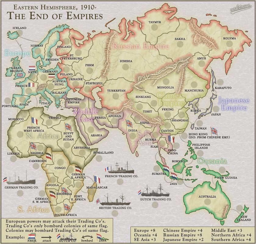
We're back to the old legend color for the bonus info. It's fine.
Played around with some ocean filters and gave the land a slight glow, which I now think is too light. Eh.
To get us up to the attractive 69 starting territories I've added Hong Kong, but it is not a part of a bonus region. It doesn't really belong as a part of the Chinese Empire, which existed just fine in 1910 without Hong Kong thank you very much. It is still bombardable by the British Trading Company - no, you'd never hit it to knock out an opponent's bonus, but who knows you might hit it for an easy card.
Which brings us to the north africa issue. it has been pointed out that France can directly invade N. Africa - which makes sense because they did - but that it can also use it's trading co to bombard it. I think this is fine for two reason:
- the player who owns France may not also control the trading company. Just because they share a flag does not mean they will always be controlled by one player over the course of a game.
- Sometimes you would rather bombard an opponent than attack directly. I've used the artillery in Berlin to bombard territories that i could have captured, but as I knew I would just lose it right back... let my opponent wipe out a neutral army while I maintain my defenses where I need them.
Re: Eastern Hemisphere: pg. 14 [I]
Posted: Wed Jul 23, 2008 2:52 am
by pamoa
oaktown wrote:Played around with some ocean filters and gave the land a slight glow, which I now think is too light.
I think you should switch the glow to blue so it blend into ocean.
Re: Eastern Hemisphere: pg. 14 [I]
Posted: Wed Jul 23, 2008 9:30 am
by MrBenn
I'm not a big fan of the canvas texture in the ocean... perhaps you could turn it down a bit and make it subtler?
pamoa wrote:I think you should switch the glow to blue so it blend into ocean.
Good idea

Re: Eastern Hemisphere: pg. 14 [I]
Posted: Wed Jul 23, 2008 12:36 pm
by whitestazn88
oh yeah, hooray for me for coming up with the idea to get to the sweet 69 territs.
i don't really like the ocean texture. it looks like a.... i dunno, i can't describe it, but its definitely not ocean-y
Re: Eastern Hemisphere: pg. 14 [I]
Posted: Thu Jul 24, 2008 7:23 pm
by AndyDufresne
Well looky here! This map is coming along. (Finally was able to make some time for the Foundry, promise I'll be around more now.

)
I prefered the old background, but the new one may still be good...toned down a little.
The rivers look good, and the mountains I'll live with.
The bottom legends look alright, I'd maybe add a bullet or some sort of anchor point left of the continents names...but that might make it too cluttered.
Perhaps darken the the Morocco - Spain route in the sea...and the German Trading Company looks oddly washed out and faded.
In regards to Hong Kong, I like the addition of it, but what if you enlarged it slightly more on the map (I'm sure it isn't to scale anyways...

) and add the flag to the land, rather than floating in the sea?
Anyways...very good job! Keep up the work.
--Andy
Re: Eastern Hemisphere: pg. 14 [I]
Posted: Thu Jul 24, 2008 10:33 pm
by BaldAdonis
I think Hong Kong will be confusing to players, being the same colour but not part of the bonus. You've also stripped Canton of its status as a port by putting it in. Might I suggest Sierra Leone instead? Takes a piece out of North Africa and gives Liberia a neighbour. One fewer dead end, and a British colony if you need more.
Re: Eastern Hemisphere: pg. 14 [I]
Posted: Thu Jul 24, 2008 11:42 pm
by whitestazn88
i thought hong kong was just a grey color...
Re: Eastern Hemisphere: pg. 14 [I]
Posted: Sat Jul 26, 2008 5:11 pm
by The Viking
Wasn't New Guinea a dutch colony in 1910?
Sorry if this has already been discussed.
Re: Eastern Hemisphere: pg. 14 [I]
Posted: Mon Jul 28, 2008 7:34 pm
by iancanton
hong kong is an addition that fits the empire theme, though awkward to draw. it's actually an island plus a peninsula. the latter's border with mainland china can be drawn as a virtually straight line, as shown in the map below. hong kong territory doesn't cut into canton territory in any way, but juts out into the sea.
http://www.hktrader.net/common/PRD_map.htm
it's obviously too small to appear its real size. can u try exaggerating the peninsula and island (by about ten times!) to see if hong kong can be a reasonably recognisable shape? the colour of the chinese empire will need to be swapped, perhaps with the middle east, since it's currently impossible to tell be colour alone whether it includes hong kong. rather than “ind from chinese empire”, “not in chinese empire” is simpler.
The Viking wrote:Wasn't New Guinea a dutch colony in 1910?
Sorry if this has already been discussed.
new guinea was split among the dutch (western part), british (southeastern part) and germans (northeastern part). we can stick a flag on it if it helps gameplay, otherwise let's leave it as it is and not split new guinea into two or three bits. now that australia and new zealand have no flags, the bonus is looking a bit high compared with the chinese empire. reduce to +3?
http://en.wikipedia.org/wiki/New_Guinea
the smaller islands of oceania might benefit from being given a thinner inner glow, similar to the one in japan.
the legend, which is clear and concise, does look neater in the box rather than in the sea.
ian.
Re: Eastern Hemisphere: pg. 14 [I]
Posted: Mon Jul 28, 2008 8:24 pm
by mibi
this map is real classy... i would love to see the text on curved paths though.. as the stright text just seems to stick out us unauthentic.
Re: Eastern Hemisphere: pg. 14 [I]
Posted: Wed Jul 30, 2008 11:28 am
by oaktown
The Viking wrote:Wasn't New Guinea a dutch colony in 1910?
like ian said, New Guinea at the beginning of the 20th century seemed to be something of a mess, with the Dutch, British, and Germans each controlling an area. Since the Dutch already have a good deal of influence in that area of the map, it seemed best just to leave New Guinea as is.
Hong Kong does, indeed, fit the theme of the map brilliantly, but I agree that it isn't a good fit visually. I like the idea of introducing another colony in Asia rather than in Africa, which is already going to get bitch-slapped by Europe, but I think the existence of a territory there is just too confusing. And while Russia would be the easiest place to add a territory, it doesn't work so well historically or in terms of gameplay - Russia is already a huge region that will be nearly impossible to conquer until late in the game.
Hmm... I just had a rethink...I'm going to split Africa into three regions, rather than two. This will make it easier to add a territory and make Africa a better start. Look for an update soon.
Re: Eastern Hemisphere: pg. 14 [I]
Posted: Wed Jul 30, 2008 12:54 pm
by oaktown
... and here it is. Ta da!
- Click image to enlarge.
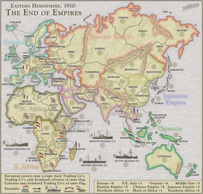
Big change in this version is that Hong Kong is out, and British East Africa is in. There is now a third bonus region in Africa - the Horn - which gives a +1 for three territories held with two borders to defend. It makes the northern half of Africa a viable start with a three and a six territory region, and brings us up to the number of territories we've been after to make two/three player games a decent start. Gave it a gray color because everything else is taken.
Discuss... and where's that gameplay stamper??
Re: Eastern Hemisphere: new terit/region, pg. 15 [I]
Posted: Wed Jul 30, 2008 1:07 pm
by yeti_c
Love it all - except the difference between north and horn africa looks a bit funny - like there's a massive Cliff there or something?
Gotta be worth a coupla stamps soon.
C.
Re: Eastern Hemisphere: new terit/region, pg. 15 [I]
Posted: Wed Jul 30, 2008 1:11 pm
by InkL0sed
I'm thinking the Horn should maybe be a +2? It borders a LOT of territories, AND can be bombarded...
Re: Eastern Hemisphere: new terit/region, pg. 15 [I]
Posted: Wed Jul 30, 2008 1:37 pm
by oaktown
InkL0sed wrote:I'm thinking the Horn should maybe be a +2? It borders a LOT of territories, AND can be bombarded...
I thought about that, but really it only borders three territories plus the bombardment, and the bombardment comes against a territory that is already a border. Relative to the way we've structured the rest of the bonuses I think +1 works - compare it to Japan (four terits, three borders) which seems pretty solid at +2.
Of course, we could increase Japan to +3, but in my opinion the small regions that are in harm's way - Middle East and S.E. Asia - deserve a bigger bonus than the small regions that are safely tucked away in corners - the Horn and Japan.
Re: Eastern Hemisphere: new terit/region, pg. 15 [I]
Posted: Wed Jul 30, 2008 11:02 pm
by AndyDufresne
I agree with your sentiments about the bonuses, Oaktown. British East Africa feels leaps and bounds better than Hong Kong. And as you mentioned, it only helps make Africa a viable area to play in, rather than a Wasteland Russia.
--Andy
Re: Eastern Hemisphere: new terit/region, pg. 15 [I]
Posted: Wed Jul 30, 2008 11:11 pm
by WidowMakers
Lookin' good oaktown.
I do have a small question. Are the mountains impassable?
Because if they are then you really can't attack New Zealand from Australia.
And if they aren't then the map is really open. I think you might need to say that somewhere.

Re: Eastern Hemisphere: new terit/region, pg. 15 [I]
Posted: Wed Jul 30, 2008 11:17 pm
by edbeard
WidowMakers wrote:Lookin' good oaktown.
I do have a small question. Are the mountains impassable?
Because if they are then you really can't attack New Zealand from Australia.
And if they aren't then the map is really open. I think you might need to say that somewhere.
there's a tiny bit of land in between that mountain and the water route, but if you're confused then definitely worth looking at changing something
Re: Eastern Hemisphere: new terit/region, pg. 15 [I]
Posted: Wed Jul 30, 2008 11:34 pm
by AndyDufresne
Good spot on the mountains...perhaps simply a little more coastline, with an alteration of the route around the mountains (either above or below), would help clear that up...as it does look odd.
--Andy
Re: Eastern Hemisphere: new terit/region, pg. 15 [I]
Posted: Thu Jul 31, 2008 1:49 am
by oaktown
AndyDufresne wrote:Good spot on the mountains...perhaps simply a little more coastline, with an alteration of the route around the mountains (either above or below), would help clear that up...as it does look odd.
geez, you people... you tell me to put the mountains in eastern australia, then you tell me that they look impassable. If it weren't for this silly "community" I would make perfect maps the first time.

But yes, I'll nudge both the mountains and the attack route from NZ. And I agree with the above sentiments on the border to the Horn of Africa - compared to everything else on the map it is overdrawn and a bit exaggerated.
Re: Eastern Hemisphere: new terit/region, pg. 15 [I]
Posted: Thu Jul 31, 2008 2:09 am
by whitestazn88
looks ok, i like the gameplay improvement that the horn brings though
Re: Eastern Hemisphere: new terit/region, pg. 15 [I]
Posted: Thu Jul 31, 2008 2:37 am
by pamoa
About colors, the horn is too similar to north africa.
Proposition, switch the three following regions color like this:
- put the green of oceania in the horn
put the grey of the horn in se asia
put the pink of se asia in oceania
You also have some scratches on the iceland - england attack route