Quad Cities Map [Quenched]
Moderator: Cartographers
Re: Quad Cities Map
![]() by jefjef on Tue Mar 08, 2011 12:32 pm
by jefjef on Tue Mar 08, 2011 12:32 pm
Need to lighten the plane image in Moline on the one map. Now that jump/connect is the flow that was needed. 
This post was made by jefjef who should be on your ignore list.

drunkmonkey wrote:I'm filing a C&A report right now. Its nice because they have a drop-down for "jefjef".
-

 jefjef
- Posts: 6026
- Joined: Mon Feb 23, 2009 8:41 pm
- Location: on my ass


Re: Quad Cities Map
![]() by natty dread on Tue Mar 08, 2011 12:38 pm
by natty dread on Tue Mar 08, 2011 12:38 pm
Actually, I'd prefer leaving the plane as is and moving it away from under the territory label.

-

natty dread
- Posts: 12877
- Joined: Fri Feb 08, 2008 8:58 pm
- Location: just plain fucked


Re: Quad Cities Map
![]() by jefjef on Tue Mar 08, 2011 1:05 pm
by jefjef on Tue Mar 08, 2011 1:05 pm
ACTUALLY if the planes were done in WHITE they and the tert name would be highly visible - look really good on the map and work well with the bridges also being white. 
This post was made by jefjef who should be on your ignore list.
drunkmonkey wrote:I'm filing a C&A report right now. Its nice because they have a drop-down for "jefjef".
-
jefjef
- Posts: 6026
- Joined: Mon Feb 23, 2009 8:41 pm
- Location: on my ass
Re: Quad Cities Map
![]() by ironsij0287 on Tue Mar 08, 2011 1:48 pm
by ironsij0287 on Tue Mar 08, 2011 1:48 pm
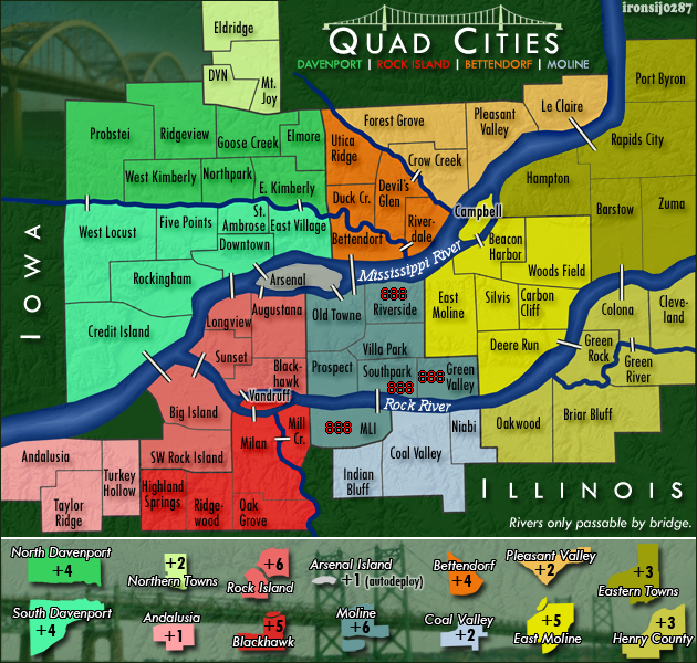
I'm still not sold on having the Airports able to attack each other. Its fine up at DVN but at MLI you're talking having 2 territories in Moline that have 3 regions able to attack it. Moline will be difficult enough to hold down. Allowing DVN to attack MLI may make it near impossible.
-

ironsij0287
- Posts: 379
- Joined: Tue Nov 09, 2010 2:30 pm
- Location: Dubuque


Re: Quad Cities Map
![]() by jefjef on Tue Mar 08, 2011 2:01 pm
by jefjef on Tue Mar 08, 2011 2:01 pm
ironsij0287 wrote:I'm still not sold on having the Airports able to attack each other. Its fine up at DVN but at MLI you're talking having 2 territories in Moline that have 3 regions able to attack it. Moline will be difficult enough to hold down. Allowing DVN to attack MLI may make it near impossible.
Well in reality I don't actually see anyone taking and holding Moline bonus anyway and you really need some movement potential other than the bridges.
You could even consider moving Moline Intl to the Coal Valley bonus region. Whoever takes that will want to take the MLI tert for defensive purposes anyway and that could make Moline bonus region a little more attractive instead of just a bunch of terts in the way.
This post was made by jefjef who should be on your ignore list.
drunkmonkey wrote:I'm filing a C&A report right now. Its nice because they have a drop-down for "jefjef".
-
jefjef
- Posts: 6026
- Joined: Mon Feb 23, 2009 8:41 pm
- Location: on my ass
Re: Quad Cities Map
![]() by natty dread on Tue Mar 08, 2011 2:08 pm
by natty dread on Tue Mar 08, 2011 2:08 pm
Ok, anyway, if the airports don't attack each other, then you should remove the plane icons, because they are likely to confuse people.
-
natty dread
- Posts: 12877
- Joined: Fri Feb 08, 2008 8:58 pm
- Location: just plain fucked
Re: Quad Cities Map
![]() by ironsij0287 on Tue Mar 08, 2011 2:31 pm
by ironsij0287 on Tue Mar 08, 2011 2:31 pm
Maps sans planes and I removed the splotch on the big map in the legend.
jefjef, I understand where you're coming from but right now I like how all the connections are currently. It truly reflects how the Iowa and Illinois side of the QCA are connected.
For now I'm going to leave it as is, but once it gets into real play in Beta then maybe that connection will end up being wanted.
- Click image to enlarge.
- Click image to enlarge.

-
ironsij0287
- Posts: 379
- Joined: Tue Nov 09, 2010 2:30 pm
- Location: Dubuque
Re: Quad Cities Map
![]() by isaiah40 on Tue Mar 08, 2011 2:45 pm
by isaiah40 on Tue Mar 08, 2011 2:45 pm
Well, this is looking really good. One little thing. Can you post the small with the 888's on it so we can see how the numbers will fit please? Also I don't know if you posted this or not, but can you put up the color blind checks as well please. Other than these couple of things, I don't see anything that would hold this up too much longer (though one of my counterparts may see something I missed).
As it stands I'm fine with it!
As it stands I'm fine with it!
-
isaiah40
- Posts: 3990
- Joined: Mon Aug 27, 2007 7:14 pm


Re: Quad Cities Map
![]() by ironsij0287 on Tue Mar 08, 2011 2:51 pm
by ironsij0287 on Tue Mar 08, 2011 2:51 pm
isaiah40 wrote:Well, this is looking really good. One little thing. Can you post the small with the 888's on it so we can see how the numbers will fit please? Also I don't know if you posted this or not, but can you put up the color blind checks as well please. Other than these couple of things, I don't see anything that would hold this up too much longer (though one of my counterparts may see something I missed).
As it stands I'm fine with it!
The 888's are on the older version of the small map on the previous page. They all fit fine then and nothing has been altered that would change that. Also I believe someone ran the colorblindness test way, way back at some point and it came out fine.
-
ironsij0287
- Posts: 379
- Joined: Tue Nov 09, 2010 2:30 pm
- Location: Dubuque
Re: Quad Cities Map
![]() by RjBeals on Tue Mar 08, 2011 8:20 pm
by RjBeals on Tue Mar 08, 2011 8:20 pm
there's nothing special about this map. The graphics are bland, and the area is totally unknown. Just a bunch of squares and some plain font. The only thing of interest is the relief background.
granted, i made a charleston, south carolina map, so I shouldn't judge you on your city.... but this is sort of boring.
Whats special about this? Just becuase it's 4 cities close together? And I guess it has a rounded bridge?
granted, i made a charleston, south carolina map, so I shouldn't judge you on your city.... but this is sort of boring.
Whats special about this? Just becuase it's 4 cities close together? And I guess it has a rounded bridge?

-

RjBeals
- Posts: 2506
- Joined: Mon Nov 20, 2006 5:17 pm
- Location: South Carolina, USA


Re: Quad Cities Map
![]() by ironsij0287 on Tue Mar 08, 2011 10:39 pm
by ironsij0287 on Tue Mar 08, 2011 10:39 pm
RjBeals wrote:there's nothing special about this map. The graphics are bland, and the area is totally unknown. Just a bunch of squares and some plain font. The only thing of interest is the relief background.
granted, i made a charleston, south carolina map, so I shouldn't judge you on your city.... but this is sort of boring.
Whats special about this? Just becuase it's 4 cities close together? And I guess it has a rounded bridge?
Really? Are you a dick to most people making maps? Can I go shit on yours?
-
ironsij0287
- Posts: 379
- Joined: Tue Nov 09, 2010 2:30 pm
- Location: Dubuque
Re: Quad Cities Map
![]() by RjBeals on Wed Mar 09, 2011 7:07 am
by RjBeals on Wed Mar 09, 2011 7:07 am
I'm not a dick, and when I was making maps (here), not all the comments were positive.
I'm pretty sure that you'll move on, and one day this map will be live.
I'm pretty sure that you'll move on, and one day this map will be live.
-
RjBeals
- Posts: 2506
- Joined: Mon Nov 20, 2006 5:17 pm
- Location: South Carolina, USA
Re: Quad Cities Map
![]() by Bruceswar on Wed Mar 09, 2011 7:48 am
by Bruceswar on Wed Mar 09, 2011 7:48 am
ironsij0287 wrote:RjBeals wrote:there's nothing special about this map. The graphics are bland, and the area is totally unknown. Just a bunch of squares and some plain font. The only thing of interest is the relief background.
granted, i made a charleston, south carolina map, so I shouldn't judge you on your city.... but this is sort of boring.
Whats special about this? Just becuase it's 4 cities close together? And I guess it has a rounded bridge?
Really? Are you a dick to most people making maps? Can I go shit on yours?
While I like the map in general, RJ has a point. It is semi bland and maybe you could spice it up. I am not exactly sure how just yet but I will think on it and come back with some advice.
Looking forward to playing this one.
P.S. Where is Donahue!
Highest Rank: 26 Highest Score: 3480

-

Bruceswar
- Posts: 9713
- Joined: Sun Dec 23, 2007 12:36 am
- Location: Cow Pastures


Re: Quad Cities Map
![]() by ironsij0287 on Wed Mar 09, 2011 8:46 am
by ironsij0287 on Wed Mar 09, 2011 8:46 am
Bruceswar wrote:ironsij0287 wrote:RjBeals wrote:there's nothing special about this map. The graphics are bland, and the area is totally unknown. Just a bunch of squares and some plain font. The only thing of interest is the relief background.
granted, i made a charleston, south carolina map, so I shouldn't judge you on your city.... but this is sort of boring.
Whats special about this? Just becuase it's 4 cities close together? And I guess it has a rounded bridge?
Really? Are you a dick to most people making maps? Can I go shit on yours?
While I like the map in general, RJ has a point. It is semi bland and maybe you could spice it up. I am not exactly sure how just yet but I will think on it and come back with some advice.
Looking forward to playing this one.
P.S. Where is Donahue!
Donahue is too far off the map to include.
Look, this was my first go at a map and if I could start over again I would've spent more time laying out a more decorative element to it. But I'm happy with how it is and don't see the need to completely overhaul the thing to make it seem less "boring".
The criticisms of this map I will keep in consideration when I do the next map.
-
ironsij0287
- Posts: 379
- Joined: Tue Nov 09, 2010 2:30 pm
- Location: Dubuque
Re: Quad Cities Map
![]() by natty dread on Wed Mar 09, 2011 9:36 am
by natty dread on Wed Mar 09, 2011 9:36 am
Well I think, graphically, it works. It's not exceptional or dazzling, but all the elements are in balance, it is clear, readable and simple.
-
natty dread
- Posts: 12877
- Joined: Fri Feb 08, 2008 8:58 pm
- Location: just plain fucked
Re: Quad Cities Map
![]() by isaiah40 on Wed Mar 09, 2011 9:42 am
by isaiah40 on Wed Mar 09, 2011 9:42 am
natty_dread wrote:Well I think, graphically, it works. It's not exceptional or dazzling, but all the elements are in balance, it is clear, readable and simple.
I agree!!
-
isaiah40
- Posts: 3990
- Joined: Mon Aug 27, 2007 7:14 pm
Re: Quad Cities Map
![]() by ironsij0287 on Wed Mar 09, 2011 3:10 pm
by ironsij0287 on Wed Mar 09, 2011 3:10 pm
isaiah40 wrote:natty_dread wrote:Well I think, graphically, it works. It's not exceptional or dazzling, but all the elements are in balance, it is clear, readable and simple.
I agree!!
So is it ready to move on in all it's underwhelming glory?
-
ironsij0287
- Posts: 379
- Joined: Tue Nov 09, 2010 2:30 pm
- Location: Dubuque
Re: Quad Cities Map
![]() by isaiah40 on Wed Mar 09, 2011 3:30 pm
by isaiah40 on Wed Mar 09, 2011 3:30 pm
Here's an idea for you to spice it up (no major changes or that), Can you squeeze the legend down just a little and add in a fun fact about the area? I found this here with some interesting facts about the area. I think it would be a good idea to something like this.
-
isaiah40
- Posts: 3990
- Joined: Mon Aug 27, 2007 7:14 pm
Re: Quad Cities Map
![]() by Bruceswar on Thu Mar 10, 2011 1:12 am
by Bruceswar on Thu Mar 10, 2011 1:12 am
If you could give the territories a bit more pop it would make this map 10 fold better. And yes I did not donahue is too far north to make it. At least Eldrige made it.
Highest Rank: 26 Highest Score: 3480
-
Bruceswar
- Posts: 9713
- Joined: Sun Dec 23, 2007 12:36 am
- Location: Cow Pastures
Re: Quad Cities Map
![]() by jefjef on Thu Mar 10, 2011 1:16 am
by jefjef on Thu Mar 10, 2011 1:16 am
Bruceswar wrote:If you could give the territories a bit more pop it would make this map 10 fold better. And yes I did not donahue is too far north to make it. At least Eldrige made it.
lol. Donahue isn't really even recognized by us natives. lol
Hey irons put a catfish or a walleye on the map somewhere. Thats what we catch around here out of the Miss and Rock or maybe even a an Image of a tractor considering Deere and Co headquarters is here.
This post was made by jefjef who should be on your ignore list.
drunkmonkey wrote:I'm filing a C&A report right now. Its nice because they have a drop-down for "jefjef".
-
jefjef
- Posts: 6026
- Joined: Mon Feb 23, 2009 8:41 pm
- Location: on my ass
Re: Quad Cities Map
![]() by natty dread on Thu Mar 10, 2011 1:31 am
by natty dread on Thu Mar 10, 2011 1:31 am
Try a very slight bevel for the land area.
-
natty dread
- Posts: 12877
- Joined: Fri Feb 08, 2008 8:58 pm
- Location: just plain fucked
Re: Quad Cities Map
![]() by ironsij0287 on Thu Mar 10, 2011 10:54 am
by ironsij0287 on Thu Mar 10, 2011 10:54 am
natty_dread wrote:Try a very slight bevel for the land area.
I'm not sure how.
-
ironsij0287
- Posts: 379
- Joined: Tue Nov 09, 2010 2:30 pm
- Location: Dubuque
Re: Quad Cities Map
![]() by natty dread on Thu Mar 10, 2011 11:07 am
by natty dread on Thu Mar 10, 2011 11:07 am
What software were you using again..?
-
natty dread
- Posts: 12877
- Joined: Fri Feb 08, 2008 8:58 pm
- Location: just plain fucked
Re: Quad Cities Map
![]() by ironsij0287 on Thu Mar 10, 2011 11:11 am
by ironsij0287 on Thu Mar 10, 2011 11:11 am
natty_dread wrote:What software were you using again..?
A combination of ArcGIS and Photoshop. The territories are all built in ArcMap and then exported into PS. But they're in a raster format in PS not vector.
-
ironsij0287
- Posts: 379
- Joined: Tue Nov 09, 2010 2:30 pm
- Location: Dubuque
Who is online
Users browsing this forum: No registered users
|
|||||||
| Conquer Club is not associated with RISK online in any way. Copyright © 2006-2024 by Big Wham LLC | |||||||