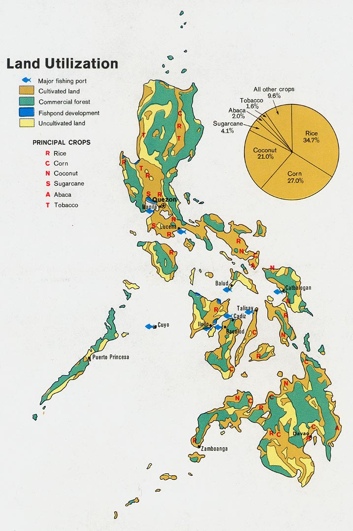
Philippines Map revealed!! [Quenched]
Moderator: Cartographers
![]() by Banana Stomper on Mon May 15, 2006 4:59 pm
by Banana Stomper on Mon May 15, 2006 4:59 pm
I still find it unpleasant to look at. Everything is very flat and very secluded. I don't know how anyone else feels about it, but i don't think i'd play it. Perhaps graphics or something to fill in the large open spaces in the middle, and the legend will take away this nearly sickening effect, but as it stands, i dont' like it very much.
-
 Banana Stomper
- Posts: 422
- Joined: Thu Mar 16, 2006 4:39 pm
- Location: Richmond, Virginia


![]() by kevinc on Tue May 16, 2006 11:19 am
by kevinc on Tue May 16, 2006 11:19 am
Marvaddin wrote:Only for register, some of these minor problems you are talking about are caused by the jpg conversion.
If it's the jaggyness people are referring to it's because things are not anti-aliased. I'm not sure what software you're using but most packages support antialiasing text and lines.
-

kevinc
- Posts: 182
- Joined: Tue Mar 14, 2006 4:47 pm
- Location: Dublin


![]() by Banana Stomper on Tue May 16, 2006 6:01 pm
by Banana Stomper on Tue May 16, 2006 6:01 pm
you can get a trial version of photoshop, it runs out eventually, but you could definitely pull off some quality maps
and its not impossible
and its not impossible
-
Banana Stomper
- Posts: 422
- Joined: Thu Mar 16, 2006 4:39 pm
- Location: Richmond, Virginia
![]() by Marvaddin on Tue May 16, 2006 6:41 pm
by Marvaddin on Tue May 16, 2006 6:41 pm
I know, but Im not looking for a tool for this map, but for this and my future maps / other things... I hope you can give me a better tip, banana. Thanks.
(Hmm, by the way, in Portuguese, hope = expect. Would I be unpolite if I have used expect? Not my goal, of course.)
(Hmm, by the way, in Portuguese, hope = expect. Would I be unpolite if I have used expect? Not my goal, of course.)

-

Marvaddin
- Posts: 2545
- Joined: Thu Feb 09, 2006 5:06 pm
- Location: Belo Horizonte, Brazil


![]() by thegrimsleeper on Tue May 16, 2006 6:45 pm
by thegrimsleeper on Tue May 16, 2006 6:45 pm
Last edited by thegrimsleeper on Wed May 17, 2006 4:02 pm, edited 2 times in total.
-

thegrimsleeper
- Posts: 984
- Joined: Thu Jan 26, 2006 10:40 am
- Location: Seattle

![]() by Banana Stomper on Tue May 16, 2006 8:06 pm
by Banana Stomper on Tue May 16, 2006 8:06 pm
Marvaddin wrote:I know, but Im not looking for a tool for this map, but for this and my future maps / other things... I hope you can give me a better tip, banana. Thanks.
(Hmm, by the way, in Portuguese, hope = expect. Would I be unpolite if I have used expect? Not my goal, of course.)
Good call in going with hope. Expect probably would have han an impolite air to it. Best of luck with whatever grim sent ya.
-
Banana Stomper
- Posts: 422
- Joined: Thu Mar 16, 2006 4:39 pm
- Location: Richmond, Virginia
![]() by kevinc on Wed May 17, 2006 3:55 pm
by kevinc on Wed May 17, 2006 3:55 pm
Marvaddin wrote:Thanks for the feedback, guys...
I will try post a new version on weekend... For now, I would appreciate some suggestions of free, intuitive and good graphics editor.
Inkscapeis an Open Source Vector tool. Vector tools take awhile to get used to, if you're used to bitmap tools (like paint) but they're perfect for this kind of thing.
Also, Paint.Net is a free tool that is like a very very basic version of Photoshop.
Both should help you out and are free.
Good luck!
-
kevinc
- Posts: 182
- Joined: Tue Mar 14, 2006 4:47 pm
- Location: Dublin
![]() by Marvaddin on Mon May 22, 2006 1:02 am
by Marvaddin on Mon May 22, 2006 1:02 am

New update. I cut some parts of the background, so the file is smaller and I can upload the png format.
As said:
- bit more darker.
- bigger Cagayan
- Malaysia present
- some names re-positioned
Also, routes and names have now better graphics. But I still didnt do the legend... How is it going for now?
-
Marvaddin
- Posts: 2545
- Joined: Thu Feb 09, 2006 5:06 pm
- Location: Belo Horizonte, Brazil
![]() by Semanticprison on Mon May 22, 2006 1:16 am
by Semanticprison on Mon May 22, 2006 1:16 am
I dont have the greatest color vision, and to me the orange and green blend together. I think it would help to switch a diff color with the orange.
-
Semanticprison
- Posts: 8
- Joined: Wed May 10, 2006 3:25 am
![]() by Jota on Mon May 22, 2006 1:52 am
by Jota on Mon May 22, 2006 1:52 am
I don't think switching to PNG has helped the aliasing issues, unfortunately. If you look closely at the edges of your continents, you'll noticed that they're all straight lines and right angles, very jagged. It's especially visible in the tiny islands around Jolo: they look like little squares.
-

Jota
- Posts: 634
- Joined: Wed Mar 29, 2006 7:38 pm


![]() by Marvaddin on Mon May 22, 2006 9:10 am
by Marvaddin on Mon May 22, 2006 9:10 am
Malaysia is there occupying an empty space, and since its really there in real life, I dont see any problem.
About the little islands, little squares is what I think they should really seem... Any problem with that? Maybe you can suggest how they should be then, Jota. The same for the borders, this IS the way I like them... if you can suggest something more "visible", I can change my mind.
More people having problems with colours?
-
Marvaddin
- Posts: 2545
- Joined: Thu Feb 09, 2006 5:06 pm
- Location: Belo Horizonte, Brazil
![]() by kevinc on Mon May 22, 2006 4:37 pm
by kevinc on Mon May 22, 2006 4:37 pm
I wouldn' tcut out the background like that. It looks very strange.
Text is much more readable now it's anti-alised. I'd suggest maybe not using italic text, or else make it larger. That will make it even more legible.
Still looking forward to playing this map.
Text is much more readable now it's anti-alised. I'd suggest maybe not using italic text, or else make it larger. That will make it even more legible.
Still looking forward to playing this map.
-
kevinc
- Posts: 182
- Joined: Tue Mar 14, 2006 4:47 pm
- Location: Dublin
![]() by Pedronicus on Mon May 29, 2006 6:38 pm
by Pedronicus on Mon May 29, 2006 6:38 pm
is this ever going to be published?
we seem to have no new maps for ages - and then 3 turn up at once....
for once - i wont have to contemplate if a squiggly brown skid mark is a non crossable border. (Who wants to walk through all that shit?)
I've got my outboard motor powered up, and up for some island hoping.
we seem to have no new maps for ages - and then 3 turn up at once....
for once - i wont have to contemplate if a squiggly brown skid mark is a non crossable border. (Who wants to walk through all that shit?)
I've got my outboard motor powered up, and up for some island hoping.
-
Pedronicus
- Posts: 2080
- Joined: Tue Jan 24, 2006 2:42 pm
- Location: Busy not shitting you....


![]() by Banana Stomper on Wed May 31, 2006 3:04 pm
by Banana Stomper on Wed May 31, 2006 3:04 pm
Make cuyo bigger so its not just 6 pixels. Give it some substance man!
-
Banana Stomper
- Posts: 422
- Joined: Thu Mar 16, 2006 4:39 pm
- Location: Richmond, Virginia


![]() by reverend_kyle on Sun Jun 04, 2006 1:15 am
by reverend_kyle on Sun Jun 04, 2006 1:15 am
looks very conquer club style, hate the continent bonus things though.
-

reverend_kyle
- Posts: 9250
- Joined: Tue Mar 21, 2006 4:08 pm
- Location: 1000 post club

![]() by Jota on Sun Jun 04, 2006 12:25 pm
by Jota on Sun Jun 04, 2006 12:25 pm
Mechanically, all the countries/continents/borders/bonuses look good to me. My only real complaint is the aliasing (the jagged edges, especially visible in some of the coastlines). But if no one else is bothered by it, then I guess it's just me.
As a more minor note, I think that the shapes behind the continent names and bonuses might look a little better if the ends were a bit blunted. It looks OK the way it is, but I think I'd prefer it if they weren't tapered quite so much.
As a more minor note, I think that the shapes behind the continent names and bonuses might look a little better if the ends were a bit blunted. It looks OK the way it is, but I think I'd prefer it if they weren't tapered quite so much.
-
Jota
- Posts: 634
- Joined: Wed Mar 29, 2006 7:38 pm
![]() by Haydena on Sun Jun 04, 2006 12:38 pm
by Haydena on Sun Jun 04, 2006 12:38 pm
Jota wrote:My only real complaint is the aliasing (the jagged edges, especially visible in some of the coastlines). But if no one else is bothered by it, then I guess it's just me.
You're not the only one, I hate the way it looks all jagged. It needs to be addressed in my opinion. It shouldn't be too hard to fix marv.
I also don't like the legend, you're one who gives useful critiscm of other peoples legends, and I honestly think that this, and the Brazil maps legends both leave a lot to be desired, they just look, very simple... I don't know if it's just me...
-

Haydena
- Posts: 634
- Joined: Sun Mar 19, 2006 2:43 pm
- Location: Sussex, England
Who is online
Users browsing this forum: No registered users
|
|||||||
| Conquer Club is not associated with RISK online in any way. Copyright © 2006-2024 by Big Wham LLC | |||||||