Conquer Club

Eastern Hemisphere [Quenched]

Care to peruse completed maps? Take a stroll through the Atlas.

Moderator: Cartographers

Forum rules
Please read the Community Guidelines before posting.

Re: Eastern Hemisphere: pg. 12 [I]

Postby Incandenza on Thu Jul 17, 2008 3:13 am

Wow, oak, this is looking amazing... (and I can see the rivers, it's a nice effect)

One small thing I can see: it seems like either (or both) the Persia terit name and the Middle East continent name could be slightly moved so that part of the continent name isn't under the terit name (as it is now, the only continent name to be thus sullied unless my eyes deceive me).

I have a reservation or two about how useful exactly the trading companies are going to be given their current powers. Hard to say without playing it, but they seem to be little more than nuisances. Sure, they can break continents, but armies put into them are irretrievable, and they don't have quite the reach to make them nearly as effective as artillery in, say, waterloo. I'm sure this has been discussed, but it's late and I'm putting off reading the rest of the thread 'till tomorrow or so... :D
THOTA: dingdingdingdingdingdingBOOM

Te Occidere Possunt Sed Te Edere Non Possunt Nefas Est
User avatar
Colonel Incandenza
 
Posts: 4949
Joined: Thu Oct 19, 2006 5:34 pm
Location: Playing Eschaton with a bucket of old tennis balls

Re: Eastern Hemisphere: pg. 12 [I]

Postby yeti_c on Thu Jul 17, 2008 3:44 am

AndyDufresne wrote:Looking good, I like the bottom legend now.

A few random things: A few of the flags look slightly off. Is the Germany Flag (inside the country's borders) using the same red as the others? Is the difference a real life difference in the flags? (I am unfamiliar with the flag of Germany from this era.) I'm not sure I made sense...I'll come back if I didn't. :)

Additionally, the German Flags in Africa don't seem to all look alike. The E. Africa seems to have a stronger, darker black, than the other colonies.

Lastly, I'm loving the rivers. I really appreciate the graphics of this map, even in spite of the mountain tree roots. :D Keep up the excellent work.


--Andy


I was pretty sure the German flag had yellow in it -> But it may have changed more recently... so perhaps this is the older flag? Oak?

(The E africa flag is getting some of the black border behind it bleeding through - this is due to the opacity on the flags not bein 100%)

C.
Image
Highest score : 2297
User avatar
Lieutenant yeti_c
 
Posts: 9624
Joined: Thu Jan 04, 2007 9:02 am

Re: Eastern Hemisphere: pg. 12 [I]

Postby pepperonibread on Thu Jul 17, 2008 5:51 am

yeti_c wrote:
AndyDufresne wrote:Looking good, I like the bottom legend now.

A few random things: A few of the flags look slightly off. Is the Germany Flag (inside the country's borders) using the same red as the others? Is the difference a real life difference in the flags? (I am unfamiliar with the flag of Germany from this era.) I'm not sure I made sense...I'll come back if I didn't. :)

Additionally, the German Flags in Africa don't seem to all look alike. The E. Africa seems to have a stronger, darker black, than the other colonies.

Lastly, I'm loving the rivers. I really appreciate the graphics of this map, even in spite of the mountain tree roots. :D Keep up the excellent work.


--Andy


I was pretty sure the German flag had yellow in it -> But it may have changed more recently... so perhaps this is the older flag? Oak?

(The E africa flag is getting some of the black border behind it bleeding through - this is due to the opacity on the flags not bein 100%)

C.


http://en.wikipedia.org/wiki/German_Empire
This lasted until 1918, and has the flag oak is currently using.
Image
User avatar
Corporal pepperonibread
 
Posts: 954
Joined: Sun Jan 28, 2007 4:33 pm
Location: The Former Confederacy

Re: Eastern Hemisphere: pg. 12 [I]

Postby yeti_c on Thu Jul 17, 2008 6:10 am

Case solved then - the flag is correct!!

C.
Image
Highest score : 2297
User avatar
Lieutenant yeti_c
 
Posts: 9624
Joined: Thu Jan 04, 2007 9:02 am

Re: Eastern Hemisphere: pg. 12 [I]

Postby oaktown on Thu Jul 17, 2008 10:45 am

re. flags:
ā€¢ the german flag is, indeed, the correct one for the era as has been pointed out.
ā€¢ Yeti is correct in that the the opacity isn't 100% on the flags, so the e. africa flag looks darker at the top. I dropped the opacity to fade them out a bit, but perhaps upping the opacity and given them a slight sepia or grey color overlay would have the same effect.
ā€¢ I hadn't noticed that the German red is, indeed, quite different from the french red - easy fix.

incandenza wrote:I have a reservation or two about how useful exactly the trading companies are going to be given their current powers.

re. Trading Co's:
At one point we discussed making the trading companies territories that couldn't be hit but they seemed too strong - you could knock out your opponents' bonuses remotely all game and frustrate the hell out of them. And in other early versions they were killer neutrals which reverted back each turn, but it seemed like if you lost those armies it would never be worth taking them. The current set-up seems to me like a happy medium.

The idea behind the Trading Co's is that they aren't a military power in and of themselves, but they do represent an influential arm of the European powers. As the Dutch government, you turn to your chartered Trading Co when you need them to exert influence in another part of the world, but it is not without having to devote some resources - historically it would be money or political power, but in this case we only have armies - which you will never see back. Once you put power in the hands of the Trading Company they are free to do with it as they will.

I am, of course, open to other suggestions, but the current configuration seemed to sit pretty well with those that were in on the earlier conversations.
User avatar
Captain oaktown
 
Posts: 4451
Joined: Sun Dec 03, 2006 9:24 pm
Location: majorcommand

Re: Eastern Hemisphere: pg. 12 [I]

Postby MrBenn on Thu Jul 17, 2008 10:53 am

I think the Trading Co's would be ideal candidates for a Conditional Autodeploy - ie Hold European Power & Trading Co = +2 Auto on Trading Co.

But that is an XML update away (at the very least ;-) )
Image
PB: 2661 | He's blue... If he were green he would die | No mod would be stupid enough to do that
User avatar
Lieutenant MrBenn
 
Posts: 6880
Joined: Wed Nov 21, 2007 9:32 am
Location: Off Duty

Re: Eastern Hemisphere: pg. 12 [I]

Postby oaktown on Thu Jul 17, 2008 11:12 am

MrBenn wrote:I think the Trading Co's would be ideal candidates for a Conditional Autodeploy - ie Hold European Power & Trading Co = +2 Auto on Trading Co.

But that is an XML update away (at the very least ;-) )

Right, not something we can do. They could get a +1 autodeploy as it is, especially if we make each of them a neutral 4 to start the game so they are costly to take, but giving somebody additional armies there throughout the duration of the game would make life pretty miserable for the player who is trying to start in Africa or South East Asia.

I'm really alright with them not being too powerful. I'm concerned that if they have too much going for them it will ruin the game for everybody else on the board who keeps getting whacked from behind. A Trading Co should be something that the other players have to watch out for, and not something that determines how the game will go down - after all, this map is about the waning European powers, in an era when their international influence was slipping away.
User avatar
Captain oaktown
 
Posts: 4451
Joined: Sun Dec 03, 2006 9:24 pm
Location: majorcommand

Re: Eastern Hemisphere: pg. 12 [I]

Postby ZeakCytho on Thu Jul 17, 2008 11:20 am

I think the trading cos. are good as is. Autodeploys would be a change for the worse. Conditional autodeploys would be nice, but since they can't be done right now, I'm inclined to say leave things as they are.

One thing that's been bugging me a bit: in the title, the hyphen after the 1910 is crooked and too low down. Could you either straighten it and raise it a few pixels or change it to a colon or something? Also, could you draw the borders of Portugal a bit more realistically; since you're not squeezing an army circle in the country itself like you are in the Netherlands, I think you have room to make it more accurate. Also, the coast of Iceland looks a bit off - isn't it more jagged than that in reality?

On most of the colonies, the flag is planted on the ground, as it should be. Sumatra's is kind of floating in the ocean, and so is Java's, to a lesser extent. If you flip the location of the flag and army circle on Sumatra, it should fix that. Not sure what you can do to fix Java, though. Also, could you move the German S. W. Africa flag over a few pixels to the right, for the same reason?

I love the rivers :)
User avatar
Captain ZeakCytho
 
Posts: 1251
Joined: Wed Sep 12, 2007 4:36 pm

Re: Eastern Hemisphere: pg. 11 [I]

Postby pamoa on Thu Jul 17, 2008 12:04 pm

oaktown wrote:..I'm slowly adding them... kinda like blue-grey veins!

I like the "veins" very much 8-) , as the entire graphics, keep going!
De gueules Ć  la tour d'argent ouverte, crĆ©nelĆ©e de trois piĆØces, sommĆ©e d'un donjon ajourĆ©, crĆ©nelĆ© de deux piĆØces
Gules an open tower silver, crenellated three parts, topped by a apertured turret, crenellated two parts
User avatar
Cadet pamoa
 
Posts: 1242
Joined: Sat Sep 01, 2007 3:18 am
Location: Confederatio Helvetica

Re: Eastern Hemisphere: pg. 12 [I]

Postby oaktown on Thu Jul 17, 2008 1:19 pm

Click image to enlarge.
image


I think i caught all of the changes suggested in the past 12 hours... Persia title moved, more rivers, flags more uniform color, Iceland, more rivers, Portugal border, colony flags on land when possible, and more rivers. :)
User avatar
Captain oaktown
 
Posts: 4451
Joined: Sun Dec 03, 2006 9:24 pm
Location: majorcommand

Re: Eastern Hemisphere: pg. 13 [I]

Postby yeti_c on Thu Jul 17, 2008 1:23 pm

Looks nice Smoaky!!

C.
Image
Highest score : 2297
User avatar
Lieutenant yeti_c
 
Posts: 9624
Joined: Thu Jan 04, 2007 9:02 am

Re: Eastern Hemisphere: pg. 13 [I]

Postby MrBenn on Thu Jul 17, 2008 2:25 pm

I was just wondering whether you've considered adding a slight glow to the bonus-legend text, with the appropriate region colour?
Image
PB: 2661 | He's blue... If he were green he would die | No mod would be stupid enough to do that
User avatar
Lieutenant MrBenn
 
Posts: 6880
Joined: Wed Nov 21, 2007 9:32 am
Location: Off Duty

Re: Eastern Hemisphere: pg. 13 [I]

Postby ZeakCytho on Thu Jul 17, 2008 2:34 pm

MrBenn wrote:I was just wondering whether you've considered adding a slight glow to the bonus-legend text, with the appropriate region colour?


That sounds good to me.

I had another thought. Ideally, the best way to explain the Trading Cos. attacks is with a flow chart that shows that each trading co can bombard each colony, and that each colony can bombard the trading co, but that colonies cannot bombard each other. Using the Netherlands, you'd have to add a line saying Dutch Co. can bombard/be bombarded by Java. Problem with this is that Sumatra and Java can attack each other because they border. A better example would be to use Britain and two of its non-bordering countries (Nigeria and New Zealand, for example).

The problem with this is that you have no room to show it. To get more room, you could move the German Trading Co. into the Indian Ocean. Shift the French Trading Co. north and squeeze the German go in a bit south of where the French Co. is now. Then move the text saying S. Africa to the east side of Africa. Now you can fit the attack explanations in a vertical box going from the top of where the German Trading Co. used to be down to the bottom of the map, and do the flow chart vertically instead of horizontally. I think this should all fit?

Of course, you might just think it's not worth the effort, and maybe it's not. Just some food for thought.
User avatar
Captain ZeakCytho
 
Posts: 1251
Joined: Wed Sep 12, 2007 4:36 pm

Re: Eastern Hemisphere: pg. 13 [I]

Postby MrBenn on Thu Jul 17, 2008 3:05 pm

I can see what you're getting at Zeak, but think that the way Oak has it at the moment makes most sense...
Image
PB: 2661 | He's blue... If he were green he would die | No mod would be stupid enough to do that
User avatar
Lieutenant MrBenn
 
Posts: 6880
Joined: Wed Nov 21, 2007 9:32 am
Location: Off Duty

Re: Eastern Hemisphere: pg. 13 [I]

Postby whitestazn88 on Thu Jul 17, 2008 4:04 pm

i see the rivers now, and they look pretty cool.
Lieutenant whitestazn88
 
Posts: 3128
Joined: Mon Feb 05, 2007 2:59 pm
Location: behind you

Re: Eastern Hemisphere: pg. 11 [I]

Postby iancanton on Fri Jul 18, 2008 8:31 pm

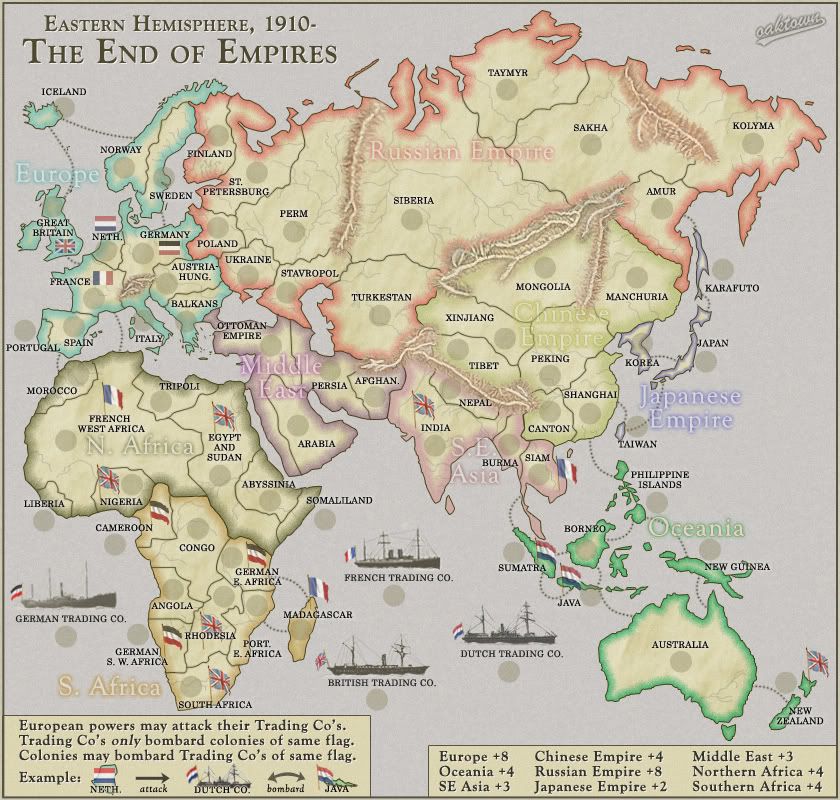
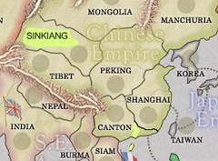
oaktown wrote:renamed Chinese Turkestan to avoid in-game confusion.

sinkiang is the traditional spelling that is contemporary with the spellings peking and canton. the new chinese spelling xinjiang became widely-used only from about 1980 onward.
iancanton wrote:adjust the border so that it is canton (currently yunnan) that has the sea link to the philippine islands.

canton was by far the number one port in southern china, partly because all foreign trade had to be conducted through canton till well into the 19th century. can u redraw the canton-shanghai border so that shanghai's southern border with canton is roughly horizontal, at the latitude of taiwan?

hainan island, in the south, was (and is) chinese, not part of a south-east asian country.

i've linked to a mock-up, where the changes are in dayglo yellow.

http://farm4.static.flickr.com/3115/268 ... 911f_m.jpg
oaktown wrote:I had Australia as a UK colony until page six...
asl80 wrote:sorry ... haven't read anything in this topic yet ... but the map looks good, only that in 1910 Australia had been federated (from 1901) and was no longer a colony of britain, though we did still shine thier boots for a long time remaining a "dominion" of britain or something of the sorts - meaning the boots we lick are still the queens ... but these have/had no official/practical bearing after federation.

I've read up a bit on this and asl80 is correct of course, though they have remained a part of the commonwealth (thus all the Aussies working in London!). If somebody can sort out New Zealand for me it'd be nice: they were also self-governing by 1910, and named an independent "Dominion" in 1907.

both australia and new zealand had full internal self-government, though foreign affairs was an empire responsibility. here's an extract from an aussie government website explaining the significance of the post-ww1 treaty of versailles in 1919. australia is described as one of the colonies of great britain. it is also a signatory of the treaty and a founding member of the league of nations. as clear as mud!

Prior to 1919 the Australian Government was frequently not even consulted regarding political treaties, which were signed by Britain for its Dominions.

With the other three British Dominions, Australia was among the 32 signatories of the Treaty, and a founding member of the League of Nations it established. This newly defined status is indicated in the list of nations on page 18 of the Treaty, where the names of Australia, Canada, New Zealand and South Africa are indented under the 'British Empire'. The Treaty recognised a new status for these nations among all the colonies of Great Britain, as only fully self-governing nations could be members of the League of Nations.


http://www.foundingdocs.gov.au/item.asp?dID=23

are u going to remove the attack route between france and french west africa? it seems odd to have, for the same colony, both a direct attack route and bombardment through the french trading company. given a choice, the latter won't be used.
oaktown wrote:I've got the map at 71 territories, of which four start neutral (the Trading Co's). Game start will look like this:
2/3 players: 22 terits each, 1 neutral

In a two player game the first player will get 7 armies to start, and can knock his opponent's bonus down by taking two territories... this won't be impossible to do and could give the first player an advantage, but really there is never going to be a perfect start for a two player game on a 60+ territory map.

Adding two territories to Japan makes Japan a tough start, and I feel as if we already have enough tough starts on this map. If the consensus is that the two player situation is that bad we could split up Japan, or we could leave Japan as is and just NOT start the Trading Companies neutral.

i see ur point about japan. it's the only truly easy start on the whole map.

two more territories will bring the 2-player start to 23 each, which means the first player must win 3 territories from his opponent to reduce the latter's initial deployment. playing sensibly, there is a less than 50% chance of this happening; the probability is more than 50% if the players start on 22 each. u've already mentioned ireland as a possibility. another, more pressing, addition is indochina, the creation of which fixes a historical faux-pas: siam was never a french colony!

ian. :)
User avatar
Colonel iancanton
Foundry Foreman
Foundry Foreman
 
Posts: 2425
Joined: Fri Jun 01, 2007 5:40 am
Location: europe

Re: Eastern Hemisphere: pg. 13 [I]

Postby cairnswk on Sat Jul 19, 2008 4:32 pm

Oaktown, any chance of placing a "vein" of mountains down the east coast of Australia to represent the Great dividing Range? - it runs from Cape York and almost hugs the coast all the way through to western Victoria.
The river systems look good there and run on the western side of the mountains.
Image
* Pearl Harbour * Waterloo * Forbidden City * Jamaica * Pot Mosbi
User avatar
Private cairnswk
 
Posts: 11510
Joined: Sat Feb 03, 2007 8:32 pm
Location: Australia

Re: Eastern Hemisphere: pg. 13 [I]

Postby asl80 on Sun Jul 20, 2008 6:56 pm

i second that motion ^

... but the australian ranges are very small (height and probably girth) compared to the others listed. (Not that this makes them any less beautiful of course, hehe)
Lieutenant asl80
 
Posts: 208
Joined: Wed Jun 27, 2007 10:07 am

Re: Eastern Hemisphere: pg. 13 [I]

Postby oaktown on Sun Jul 20, 2008 10:01 pm

ultimately I'd like to have more mountains throughout to give the map a bit more texture... australia, africa, etc. The trouble is I don't want to start making the thing any harder to read, but since Australia is one big territory adding some features won't screw anything up.
Image
User avatar
Captain oaktown
 
Posts: 4451
Joined: Sun Dec 03, 2006 9:24 pm
Location: majorcommand

Re: Eastern Hemisphere: pg. 13 [I]

Postby oaktown on Mon Jul 21, 2008 7:36 pm

Click image to enlarge.
image

Alright, I've put mountains in Australia and changed the white drop shadow behind each region title in the legend to the region's color... I'm hoping it'll grow on me. I can already see I didn't line up all of the words... and some of them were resized smaller somehow - eh, I'll have that covered in the next update.

I have also implemented some of Edbeard's suggestions (above) including adding French Indochina. This leaves me with two gameplay questions for you all:

1. If we want to add one more territory to make it a nice start for 2/3 player games, where should it be?

2. I still don't know what to do about the 'colony' status of the Ausies and Kiwis. Sounds as if the flags should come off completely since both were independently administered by the early 20th century. Hmm??
Image
User avatar
Captain oaktown
 
Posts: 4451
Joined: Sun Dec 03, 2006 9:24 pm
Location: majorcommand

Re: Eastern Hemisphere: pg. 13 [I]

Postby ZeakCytho on Mon Jul 21, 2008 8:02 pm

oaktown wrote:1. If we want to add one more territory to make it a nice start for 2/3 player games, where should it be?

Perhaps split French West Africa into two territories? If you don't want to give the French another colony, then maybe split Siberia in two?
User avatar
Captain ZeakCytho
 
Posts: 1251
Joined: Wed Sep 12, 2007 4:36 pm

Re: Eastern Hemisphere: pg. 13 [I]

Postby whitestazn88 on Tue Jul 22, 2008 3:04 am

get sri lanka going

that or hong kong/taiwan

those two suggestions in reference to the 2/3 player even starting territs question
Lieutenant whitestazn88
 
Posts: 3128
Joined: Mon Feb 05, 2007 2:59 pm
Location: behind you

Re: Eastern Hemisphere: pg. 13 [I]

Postby yeti_c on Tue Jul 22, 2008 3:34 am

oaktown wrote:
Click image to enlarge.
image

changed the white drop shadow behind each region title in the legend to the region's color... I'm hoping it'll grow on me. I can already see I didn't line up all of the words... and some of them were resized smaller somehow - eh, I'll have that covered in the next update.


Not sure I'm liking that new legend... it's a bit fuzzy.

C.
Image
Highest score : 2297
User avatar
Lieutenant yeti_c
 
Posts: 9624
Joined: Thu Jan 04, 2007 9:02 am

Re: Eastern Hemisphere: pg. 13 [I]

Postby whitestazn88 on Tue Jul 22, 2008 3:42 am

yeti makes a good point, and i agree with it...
Lieutenant whitestazn88
 
Posts: 3128
Joined: Mon Feb 05, 2007 2:59 pm
Location: behind you

Re: Eastern Hemisphere: pg. 13 [I]

Postby oaktown on Tue Jul 22, 2008 10:34 am

yeti_c wrote:Not sure I'm liking that new legend... it's a bit fuzzy.

actually it's more than a bit fuzzy. the old white shadow made the text look very crisp, and this just, well, sucks. Like I said I was hoping it grow on me, but it's not.

Since this is a common section of the world we're talking about, and since the region names are on the map, I don't see any reason at all that we need the colors in the legend. If you need a color reference to find Europe, you deserve to lose. ;)
Image
User avatar
Captain oaktown
 
Posts: 4451
Joined: Sun Dec 03, 2006 9:24 pm
Location: majorcommand

PreviousNext

Return to The Atlas

Who is online

Users browsing this forum: No registered users